38th Street (Minneapolis)

Last updated

38th Street
Minneapolis 38th Street South Food Market 1975.jpg
A food market at East 38th Street and 4th Avenue South in Minneapolis, 1975
38th Street (Minneapolis)
OwnerCity of Minneapolis
Location Minneapolis, Minnesota, United States
Nearest metro station Metro Minnesota icon.svg   Blue Line  
38th Street station
Coordinates 44°56′03″N93°15′45″W / 44.9342°N 93.2625°W / 44.9342; -93.2625
Major
junctions
I-35W.svg I-35W, Exit 14
EastEast 38th Street
WestWest 38th Street
Other
Known for
Website minneapolismn.gov

38th Street is a major east-west roadway in the U.S. city of Minneapolis and an officially designated cultural district in the Powderhorn community. [2] The area developed into a residential zone when the Chicago Avenue street car line was extended to East 38th Street in 1880. Since the 1930s, the area has featured many Black-owned businesses, and the surrounding neighborhoods have had distinct histories from other neighborhoods in Minneapolis due to racial settlement patterns that concentrated Black residents there.

Contents

After several decades of economic stagnation, the historic character of the 38th Street neighborhood changed in the 2000s with an influx of Latino residents, as the Black and White populations declined. [3] In the 2010s, concerns about gentrification resulted in residents and city leaders seeking to preserve the historic cultural characteristics of the 38th Street corridor. [4] In 2020, the murder of George Floyd took place outside the Cup Foods grocery store, which brought worldwide recognition of the 38th and Chicago street intersection. [5]

Geography

In Minneapolis, 38th Street is an east-west thorough fare. West 38th Street runs from Excelsior Boulevard to Nicollet Avenue, but is interrupted by Bde Mka Ska and Lakewood Cemetery. East 38th Street is the stretch of road from Nicollet Avenue to the West River Parkway of the Mississippi River. East 38th Street intersects with Chicago Avenue, a major north-south thoroughfare, in the city's Powderhorn community. The 38th and Chicago street intersection is a border for several city neighborhoods: Bancroft, Bryant, Central, and Powderhorn Park. [6] [7] The four neighborhoods have a distinct history in Minneapolis due to the racial and ethnic residential population and development matters over the past century. [3] The neighborhoods were home to approximately 25,000 residents by the 2020s. [8]

History

Annexation into Minneapolis

After the area was platted in the mid 1800s, 38th Street was a part of Richfield in Hennepin County. In 1867, the Minnesota Legislature created the Minneapolis Township, a separate jurisdiction from the City of Minneapolis, out of the area south of Lake Street to the northern bank of Minnehaha Creek (then named Brown's Creek). In 1883, the Powderhorn area was transferred from Minneapolis Township to the City of Minneapolis, and 38th Street became the city's southern boundary. The city annexed remaining portions of the township in 1887. [9]

Transit connection and residential growth

Residential development of the 38th Street area began in the 1870s, but was hindered by the lack of public transit to connect people to the city's downtown area. In 1880, trolley lines on Chicago Avenue were extended to 38th Street, connecting passengers to downtown. In 1926, a 38th Street bus line that ran east-west was added, and later extended a few years later. [9] The area grew into a bustling commercial intersection and neighborhood, linked by the Chicago Avenue trolley line. [10]

Residential neighborhoods along 38th Street were first populated by Swedes and Norwegians. [11] By the 1920s, the area was multi-cultural with a mixed population of African American, Jewish, and Southern and Eastern European people. Many Black residents had moved to the south Minneapolis area along 38th Street as part of the Great Migration, the northern movement of Blacks from rural southern states in the early 20th century. [12]

Spiegel Krane Drugs store at 4th Avenue and East 38th Street, July 13, 1932 Louis Spiegel and Harry Krane, proprietors of Spiegel Krane Drugs (4419476592).jpg
Spiegel Krane Drugs store at 4th Avenue and East 38th Street, July 13, 1932

Black residential and business district

From the 1930s to the 1970s, the neighborhoods along East 38th Street in Minneapolis were the center of a thriving Black residential and business district in the city's south side, [13] with many Black residents living in the area from East 34th to 46th streets south and from Nicollet to Chicago avenues. [12] In the 1900s, discriminatory housing practices in parts of the city, such as racial covenants that barred property from being transferred from White home owners to prospective Black home owners, as well as the practice of redlining, [14] had the effect of concentrating Black residents there and racial discrimination by businesses in the city's predominately White areas resulted in development and growth of Black commerce. The 38th Street corridor became a destination for both Black residents and Black visitors to Minneapolis who sought businesses who would serve them. [13] [11] East 38th Street and 4th Avenue South featured a Black-owned café, delicatessen, newspaper headquarters, and shops. [12]

Spokesman-Recorder

Founded in 1934 by Cecil Newman, the Minnesota Spokesman-Recorder is the oldest continuously operated Black newspaper in the state. It has been located near the intersection of East 38th Street and Fourth Avenue South since 1958. Its building was designated as a historic landmark in 2015. [11]

Economic and social decline

The historic Black business district was affected by construction of Interstate 35W highway in Minneapolis in 1959, which razed fifty square blocks and created a large gulf that cut across 38th Street and split the broader neighborhood in half. [11] The character of the neighborhood also changed as the population declined and the nearby Central High School closed in 1982. [3] [11] [12] From the 1980s to the 2000s, the area was affected by rising crime, declining local economic conditions, and the crack cocaine epidemic. [12] [15] [11] By the 2000s, many of the Black-owned business establishments that had a decades-long presence in the neighborhood closed. [12]

Gentrification

In the late 1900s and early 2000s, the population of both Whites and Blacks declined in the area. The area was repopulated by an influx of Latino families in search of affordable housing, and the Latino population surpassed that of either Whites or Blacks. [3] [11] [12] In the 2010s, after generations of economic stagnation, several new businesses opened in the 38th Street corridor, some by White business owners that did not live in the neighborhood. [16] [3] Several new businesses opened in store fronts that had been boarded up and vacant several years prior. [17] Concerns about gentrification led to debate about how to maintain the historic Black character of the area. [4] [3]

Murder of George Floyd

East 38th Street and Chicago Avenue, May 30, 2020 George Floyd Memorial at Chicago Avenue & 38th Street (49952803788).jpg
East 38th Street and Chicago Avenue, May 30, 2020

The 38th and Chicago street intersection was the location of the murder of George Floyd by Derek Chauvin, a police officer with the Minneapolis Police Department. Chauvin, a white man, knelt on the neck of Floyd, an unarmed Black man, for about 9 minutes and 29 seconds, on May 25, 2020. [18] [19] Soon after Floyd's murder, people left memorials to him there. The street intersection soon transitioned to an occupation protests referred to as George Floyd Square as protesters erected barricades to block vehicular traffic and transformed the space with public art of Floyd and that of other racial justice themes. [20] [21] The occupation protest persisted for over a year. [22] [23]

Cultural district designation

In 2015, residents and Minneapolis city counselors had begun planning for how to preserve African American history and culture in the area, [12] and in 2019 local officials began the 38th Street Thrive! development plan to formally establish a 38th Street cultural district. [24] As part of the Minneapolis 2040 zoning plan presented in August 2020 city officials designated the broader 38th Street South area as one of the city's seven new cultural districts to promote racial equity, preserve cultural identity, and promote economic growth. [2] The officially designated 38th Street Cultural District included the segments of 37th to 39th streets south, from Nicollet to Bloomington avenues. [1] [25]

Commemorative street names

Clarissa Rogers Walker Way: The length of 3rd Avenue South between 36th Street and 42nd Street was named in honor of Clarissa Walker, a social activist and community leader in the mid-to-late 1900s. [26]

Launa Q. Newman Way: The length of 4th Avenue South between 36th Street and 42nd Street was named in honor of Launa Q. Newman who served as president of the Minnesota Spokesman-Recorder , a newspaper founded by her husband Cecil Newman, in the late 1900s. [26]

George Perry Floyd Square: The length of Chicago Avenue between 37th and 39th streets was renamed as "George Perry Floyd Jr Place" in late 2020 to honor of George Floyd who was killed by a Minneapolis police officer outside the Cup Foods store on May 25, 2020. It was renamed "George Perry Floyd Square" in May 2022, but is more popularly referred to as "George Floyd Square". [27] [28]

See also

Related Research Articles

<span class="mw-page-title-main">Nicollet Mall</span> Shopping, transit and pedestrian space in Minneapolis

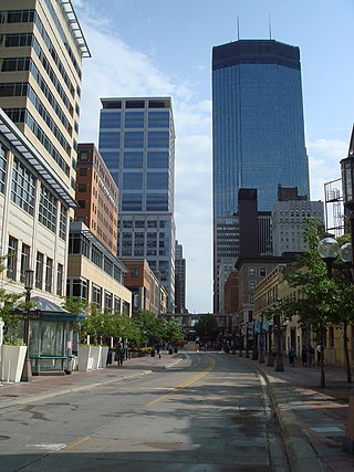
Nicollet Mall is a twelve-block portion of Nicollet Avenue running through downtown Minneapolis, Minnesota, United States. It is the shopping and dining district of the city, and also a pedestrian mall and transit mall. Along with Hennepin Avenue to the west, Nicollet Mall forms the cultural and commercial center of Minneapolis.

<span class="mw-page-title-main">Central (neighborhood), Minneapolis</span> Neighborhood in Hennepin, Minnesota, United States

The Central neighborhood of Minneapolis, Minnesota, United States is located south of the downtown region of the city. It is bounded by Lake Street on the north, Chicago Avenue on the east, 38th Street on the south, and Interstate 35W on the west. It should not be confused with the Central community, which covers Downtown and some surrounding neighborhoods.

<span class="mw-page-title-main">Whittier, Minneapolis</span> Neighborhood in Hennepin, Minnesota, United States

Whittier is a neighborhood within the Powderhorn community in the U.S. city of Minneapolis, Minnesota, bounded by Franklin Avenue on the north, Interstate 35W on the east, Lake Street on the south, and Lyndale Avenue on the west. It is known for its many diverse restaurants, coffee shops and Asian markets, especially along Nicollet Avenue. The neighborhood is home to the Minneapolis Institute of Art, the Minneapolis College of Art and Design, and the Children's Theatre Company.

<span class="mw-page-title-main">Neighborhoods of Minneapolis</span> Official communities and neighborhood of Minneapolis

The U.S. city of Minneapolis is officially defined by the Minneapolis City Council as divided into eleven communities, each containing multiple official neighborhoods. Informally, there are city areas with colloquial labels. Residents may also group themselves by their city street suffixes, North, Northeast, South, Southeast, and Southwest.

<span class="mw-page-title-main">Powderhorn Park, Minneapolis</span> Neighborhood in Hennepin, Minnesota, United States

The Powderhorn Park neighborhood of Minneapolis, Minnesota, United States is located approximately three miles south of downtown and is bordered by East Lake Street to the north, Cedar Avenue to the east, East 38th Street to the south, and Chicago Avenue to the west. Its namesake is the city's Powderhorn Park facility in the northwestern part of the neighborhood around Powderhorn Lake, which contains playing fields, playgrounds and a park building that hosts community education classes ranging from pottery to yoga. In winter, the Minneapolis Park and Recreation Board sets up a portable warming house and the lake is used for ice skating.

<span class="mw-page-title-main">Lowry Hill East, Minneapolis</span> Neighborhood in Hennepin, Minnesota, United States

Lowry Hill East is a neighborhood in southwest Minneapolis, Minnesota, United States, part of the Calhoun Isles community. Lowry Hill East developed in the 1880s along a horse-drawn streetcar line built by Thomas Lowry. The interior of the neighborhood is residential, with large early 20th century homes and multi-unit apartment buildings, while the border streets are lined with bars, restaurants, grocery stores, coffeeshops, and other small businesses. Most housing is renter-occupied.

<span class="mw-page-title-main">East Bde Maka Ska, Minneapolis</span> Neighborhood in Hennepin, Minnesota, United States

East Bde Maka Ska is a neighborhood within the Calhoun-Isles community in the U.S. city of Minneapolis. It was formerly known as East Calhoun prior to August 2021. The neighborhood is located south of the East Isles neighborhood and its northern portion along with parts of the East Isles, Lowry Hill East, and South Uptown neighborhoods forms the city's Uptown district. East Bde Maka Ska is bordered on the north by Lake Street, on the east by Hennepin Avenue, on the south by West 36th Street and on the west by Bde Maka Ska.

<span class="mw-page-title-main">Lake Street (Minneapolis)</span>

Lake Street is a major east-west thoroughfare between 29th and 31st streets in Minneapolis, Minnesota United States. From its western most end at the city's limits, Lake Street reaches the Chain of Lakes, passing over a small channel linking Bde Maka Ska and Lake of the Isles, and at its eastern most end it reaches the Mississippi River. In May 2020, the Lake Street corridor suffered extensive damage during local unrest over the murder of George Floyd. In August of the same year, city officials designated East Lake Street as one of seven cultural districts to promote racial equity, preserve cultural identity, and promote economic growth.

<span class="mw-page-title-main">Bancroft, Minneapolis</span> Neighborhood of Minneapolis

Bancroft is a neighborhood within the Powderhorn community in Minneapolis, Minnesota, United States. Its boundaries are East 38th Street to the north, Chicago Avenue to the west, East 42nd Street to the south and Cedar Avenue to the east.

<span class="mw-page-title-main">Bryant, Minneapolis</span> Neighborhood in Hennepin, Minnesota, United States

Bryant is a neighborhood within the Powderhorn community in Minneapolis, Minnesota, United States. Its boundaries are East 38th Street to the north, Chicago Avenue to the east, East 42nd Street to the south, and Interstate 35W to the west.

<span class="mw-page-title-main">Robert Lilligren</span> American politician

Robert Lilligren is an American politician and member of the Minnesota Democratic-Farmer-Labor Party. He was an elected member of the Minneapolis City Council. He was first elected in 2001, to represent the 8th Ward of the Minneapolis City Council. Following the defeat of Green Party member Dean Zimmermann, during the 2005 municipal elections, Lilligren represented the 6th Ward of the City of Minneapolis. When first elected to office, Lilligren was serving as a volunteer on eight different community boards and commissions including: vice-chair of Phillips West Neighborhood organization, the Midtown Greenway Coalition, the Hennepin County-appointed I-35W Project Advisory Committee, and as a board member for several affordable housing groups throughout South Minneapolis. He lost his re-election bid in 2013 to Abdi Warsame. He was appointed to the Metropolitan Council by Governor Tim Walz in March 2019.

<span class="mw-page-title-main">King Field, Minneapolis</span> Neighborhood in Hennepin, Minnesota, United States

King Field is a neighborhood in the Southwest community in Minneapolis, Minnesota. Its boundaries are 36th Street to the north, Interstate 35W to the east, 46th Street to the south, and Lyndale Avenue to the west. King Field, within the King Field neighborhood is a park named after Martin Luther King Jr.

<span class="mw-page-title-main">Powderhorn, Minneapolis</span> Community of Minneapolis

Powderhorn is a community in Minneapolis, which consists of eight different neighborhoods.

The George Floyd protests in Chicago were a series of civil disturbances in 2020 in the city of Chicago, Illinois. Unrest in the city began as a response to the murder of George Floyd in police custody in Minneapolis on May 25, 2020. The demonstrations and riots, supporting justice for Floyd and protesting police brutality, occurred simultaneously with those of over 100 other cities in the United States. Chicago is among 12 major cities that declared curfews in order to prevent looting and vandalism. On May 31, Mayor Lori Lightfoot asked Illinois Governor J.B. Pritzker to send the Illinois National Guard to Chicago for the first time in the 52 years since the 1968 riots in Chicago. The economic damage caused by the disturbances exceeded $125 million.

<span class="mw-page-title-main">George Floyd protests in Minneapolis–Saint Paul</span> Over murder of unarmed black man

Local protests over the murder of George Floyd began on May 26, 2020, and within a few days had inspired a global protest movement against police brutality and racial inequality. The initial events were a reaction to a video filmed the day before and circulated widely in the media of police officer Derek Chauvin kneeling on Floyd's neck for 9 minutes and 29 seconds while Floyd struggled to breathe, begged for help, lost consciousness, and died. Public outrage over the content of the video gave way to widespread civil disorder in Minneapolis, Saint Paul, and other cities in the Minneapolis–Saint Paul metropolitan area in the five-day period of May 26 to 30 after Floyd's murder.

<span class="mw-page-title-main">2020 Minneapolis false rumors riot</span> Unrest after a suicide incident

False rumors of a police shooting resulted in rioting, arson, and looting in the U.S. city of Minneapolis from August 26–28, 2020. The events began as a reaction to the suicide of Eddie Sole Jr., a 38-year old black man who was being pursued by Minneapolis police officers for his alleged involvement in a homicide. At approximately 2 p.m. on August 26, Sole died after he shot himself in the head as officers approached to arrest him. False rumors quickly spread on social media that Minneapolis police officers had fatally shot Sole. To quell unrest, Minneapolis police released closed-circuit television surveillance footage that captured Sole's suicide, which was later confirmed by a Hennepin County Medical Examiner's autopsy report.

<span class="mw-page-title-main">George Floyd Square occupied protest</span> Civil conflict at the location of George Floyds murder

The George Floyd Square occupied protest is centered at the intersection of East 38th Street and Chicago Avenue in Minneapolis, Minnesota, United States and features several makeshift memorials and street art. The street intersection is where Derek Chauvin, a White police officer with the Minneapolis Police Department, murdered George Floyd, an unarmed 46-year-old Black man, on May 25, 2020. The day after Floyd's murder, people began leaving memorials to him. The street intersection soon transitioned to a controversial occupation protest by people who had erected barricades to block vehicular traffic and transformed the space with amenities, social services, and public art of Floyd and that of other racial justice themes. The unofficial memorial and occupied protest zone was referred to as “autonomous”, "no-go", and "police-free", but local officials disputed such characterizations.

<span class="mw-page-title-main">2020 Minneapolis park encampments</span> Homeless encampments in city parks

The U.S. city of Minneapolis featured officially and unofficially designated camp sites in city parks for people experiencing homelessness that operated from June 10, 2020, to January 7, 2021. The emergence of encampments on public property in Minneapolis was the result of pervasive homelessness, mitigations measures related to the COVID-19 pandemic in Minnesota, local unrest after the murder of George Floyd, and local policies that permitted encampments. At its peak in the summer of 2020, there were thousands of people camping at dozens of park sites across the city. Many of the encampment residents came from outside of Minneapolis to live in the parks. By the end of the permit experiment, four people had died in the city's park encampments, including the city's first homicide victim of 2021, who was stabbed to death inside a tent at Minnehaha Park on January 3, 2021.

<span class="mw-page-title-main">Clarissa Walker</span>

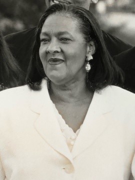
Clarissa Rogers Walker was an American social activist and community leader based in Minneapolis, Minnesota. She was known for her social contributions in the South Minneapolis area for the African-American community. She served for more than three decades as the director of Sabathani Community Center, a multi-ethnicity community service center in Minneapolis, Minnesota. In November 2019, the City Council of Minneapolis announced a commemorative honor to Walker along with activist Launa Newman by renaming and dedicating specific portions of avenues amongst the 38th Street corridor to their names respectively as a tribute to their contributions.

<span class="mw-page-title-main">George Floyd Square</span> Street in Minneapolis

George Floyd Square, officially George Perry Floyd Square, is the commemorative street name for the section of Chicago Avenue in the U.S. city of Minneapolis from East 37th Street to East 39th Street. It is named after George Floyd, a Black man who was murdered there by Minneapolis police officer Derek Chauvin on May 25, 2020. The streetway and memorial site is centered at the 38th and Chicago intersection.

References

  1. 1 2 "Cultural Districts ordinance (2020-00446)" (PDF). City of Minneapolis. August 22, 2020.
  2. 1 2 Staff (August 14, 2020). "Minneapolis City Council Approves 7 New Cultural Districts To Advance Equity, Fuel Economic Growth". WCCO . Retrieved November 25, 2020.
  3. 1 2 3 4 5 6 "Beneath the Surface: A Snapshot of CURA's Gentrification Interview Data in South Minneapolis" (PDF). Center for Urban and Regional Affairs. February 23, 2018 via University of Minnesota (online).
  4. 1 2 Lee, Jessica (September 19, 2019). "Why Minneapolis wants to create six 'cultural districts' across the city". MinnPost. Retrieved April 21, 2021.
  5. Staff (September 18, 2020). "Minneapolis City Council approves George Perry Floyd Jr. Place as commemorative name for portion of Chicago Avenue". KSTP . Retrieved November 25, 2020.
  6. "About | 38th & Chicago – South Minneapolis – We know you like family" . Retrieved April 22, 2021.
  7. "38th Street and Chicago Avenue Small Area / Corridor Framework Plan". minneapolis2040.com. Retrieved April 22, 2021.
  8. "38th and Chicago". Archived from the original on April 30, 2012. Retrieved April 28, 2021.
  9. 1 2 Neal, Baxter. "Bancroft Neighborhood Association". Bancroft Neighborhood Association. Archived from the original on October 14, 2020. Retrieved April 24, 2021.
  10. Chicago Avenue Fire Arts Center (2020). "3749 Chicago Avenue, Minneapolis". www.cafac.org/. Archived from the original on January 25, 2021. Retrieved April 28, 2021.
  11. 1 2 3 4 5 6 7 Burnside, Tina (February 1, 2017). "Southside African American Community, Minneapolis | MNopedia". www.mnopedia.org. Archived from the original on March 31, 2017. Retrieved April 29, 2021.
  12. 1 2 3 4 5 6 7 8 City of Minneapolis (February 1, 2021). "Thirty-Eight Street Thrive (Cultural District), Strategic Development Plan" (PDF). www2.minneapolismn.gov/. Archived (PDF) from the original on May 2, 2021. Retrieved May 2, 2021.
  13. 1 2 Bruch, Michelle (March 5, 2019). "38th Street revival rooted in history". Southwest Journal. Archived from the original on March 8, 2019. Retrieved April 22, 2021.
  14. Mohamed, Abdi (January 7, 2022). "Can Minneapolis restore its 'cultural districts'?". Minnesota Spokesman-Recorder . Retrieved January 7, 2022.
  15. Zorrilla, Mónica (August 7, 2019). "38th Street violence rattles community". Minnesota Spokesman-Recorder. Archived from the original on August 8, 2019. Retrieved April 28, 2021.
  16. Lindeke, Bill (July 10, 2015). "The Seward Friendship Store sparks return of the co-op war". Twin Cities Daily Planet. Archived from the original on July 12, 2015. Retrieved April 28, 2021.
  17. Pratt, Anna (February 29, 2012). "Thinking big--and delicious--at 38th and Chicago". TheLineMedia. Retrieved April 28, 2021.
  18. Levenson, Eric (March 29, 2021). "Former officer knelt on George Floyd for 9 minutes and 29 seconds -- not the infamous 8:46". CNN. Retrieved March 29, 2021.
  19. Hill, Evan; Tiefenthäler, Ainara; Triebert, Christiaan; Jordan, Drew; Willis, Haley; Stein, Robin (June 1, 2020). "How George Floyd Was Killed in Police Custody". The New York Times. ISSN   0362-4331 . Retrieved April 22, 2021.
  20. Burks, Megan; Nguyen, Christine T.; Frost, Evan (November 25, 2020). "The call for justice at 38th and Chicago persists". Minnesota Public Radio . Retrieved November 25, 2020.
  21. Nebehay, Stephanie (November 9, 2020). "U.S. criticized for police brutality, racism at U.N. rights review". Reuters. Retrieved November 25, 2020.
  22. Griswold, David (June 20, 2021). "Traffic resumes at George Floyd Square". KARE-TV . Retrieved June 21, 2021.
  23. "George Floyd Square, Uptown Intersection Reopen To Traffic". WCCO-TV . June 20, 2021. Retrieved June 21, 2021.
  24. City of Minneapolis. "Ward 8 priorities & projects". www.minneapolismn.gov. Archived from the original on January 18, 2021. Retrieved April 28, 2021.
  25. "City Council approves boundaries for seven new Cultural Districts". City of Minneapolis News. August 14, 2020. Retrieved December 14, 2020.
  26. 1 2 Minneapolis, City of. "Historical Significance of the E. 38th St. Corridor and South-Central Minneapolis". www.minneapolismn.gov. Retrieved April 28, 2021.
  27. Otárola, Miguel (August 4, 2020). "Cup Foods, site where George Floyd was killed, reopens in south Minneapolis". Star Tribune.
  28. "RCA-2022-00460 - Commemorative street name change: Council President Andrea Jenkins, Chicago Ave between 37th St E and 39th St E". lims.minneapolismn.gov. Retrieved May 23, 2022.

Further reading