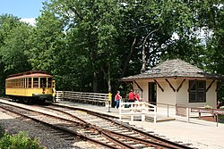
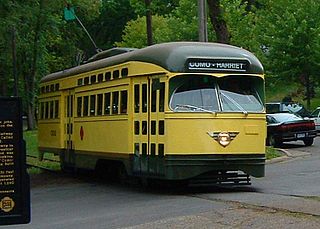
The Como-Harriet Streetcar Line (CHSL) is a heritage streetcar line in Minneapolis, Minnesota, which follows original streetcar right-of-way between Lake Harriet and Bde Maka Ska and is operated by the Minnesota Streetcar Museum. The heritage line was originally developed in the 1970s by the Minnesota Transportation Museum which spun off streetcar operations in the winter of 2004–2005.

Whittier is a neighborhood within the Powderhorn community in the U.S. city of Minneapolis, Minnesota, bounded by Franklin Avenue on the north, Interstate 35W on the east, Lake Street on the south, and Lyndale Avenue on the west. It is known for its many diverse restaurants, coffee shops and Asian markets, especially along Nicollet Avenue. The neighborhood is home to the Minneapolis Institute of Art, the Minneapolis College of Art and Design, and the Children's Theatre Company.

Uptown is a commercial district in southwestern Minneapolis in the U.S. state of Minnesota, that is centered at the intersection of Hennepin Avenue and West Lake Street. It has traditionally spanned the corners of four neighborhoods, Lowry Hill East, East Bde Maka Ska, South Uptown and East Isles neighborhoods, which are all within the Calhoun Isles community. Historically, the boundaries of Uptown are Bde Maka Ska to the west, Dupont Avenue to the east, 31st Street to the south, and 28th Street to the north; though these borders often vary. Uptown is a popular destination for retail, nightlife, and cultural events, and the district was famously written about by recording artist Prince.

Minneapolis is officially defined by its city council as divided into 83 neighborhoods. The neighborhoods are historically grouped into 11 communities. Informally, there are city areas with colloquial labels. Residents may also group themselves by their city street suffixes, North, Northeast, South, Southeast, and Southwest.

Lowry Hill East, also known as the Wedge because of its wedge-like shape, is a neighborhood in southwest Minneapolis, Minnesota, United States, part of the Calhoun Isles community. Lowry Hill East developed in the 1880s along a horse-drawn streetcar line built by Thomas Lowry. The interior of the neighborhood is residential, with large early 20th century homes and multi-unit apartment buildings, while the border streets are lined with bars, restaurants, grocery stores, coffeeshops, and other small businesses. Most housing is renter-occupied.

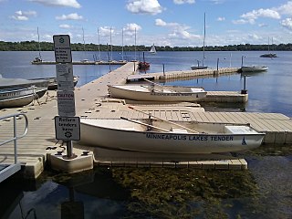
Lake Harriet is a lake in southwest Minneapolis, south of Bde Maka Ska and north of Minnehaha Creek. The lake is surrounded by parkland as part of Minneapolis’ Chain of Lakes. The lake has an area of 335 acres (1.36 km2) and a maximum depth of 85 feet (26 m).
Morningside is a distinct geographical and architectural neighborhood in Edina, Minnesota. Morningside is an old streetcar suburb adjacent to Minneapolis' Linden Hills neighborhood.
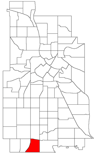
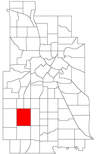
The Windom neighborhood is located in the Southwest community of Minneapolis. Its borders are Diamond Lake Road and West 54th Street to the north, Interstate 35W to the east, West 62nd Street to the south, and Lyndale Avenue South and Highway 121 to the west. Windom is a part of Ward 11, currently represented by Minneapolis City Council member Emily Koski.
The Southwest community consists of the following neighborhoods: Linden Hills, East Harriet, Kingfield, Fulton, Lynnhurst, Tangletown, Armatage, Kenny, and Windom. This portion of Minneapolis contains many parks and trails along Lake Harriet and Minnehaha Creek.

Lake Street is a major east-west thoroughfare between 29th and 31st streets in Minneapolis, Minnesota United States. From its western most end at the city's limits, Lake Street reaches the Chain of Lakes, passing over a small channel linking Bde Maka Ska and Lake of the Isles, and at its eastern most end it reaches the Mississippi River. In May 2020, the Lake Street corridor suffered extensive damage during local unrest following the murder of George Floyd. In August of the same year, city officials designated East Lake Street as one of seven cultural districts to promote racial equity, preserve cultural identity, and promote economic growth.

Longfellow is a defined community in Minneapolis, Minnesota which includes five smaller neighborhoods inside of it: Seward, Cooper, Hiawatha, Howe and Longfellow. The community is a mix of agri-industrial properties along the old Northern Pacific Railway, expansive parkland surrounding the famous Minnehaha Falls, and smaller residential areas.

Como is a neighborhood within the University community of Minneapolis. It is sometimes referred to as Southeast Como, due to many of its streets ending in SE, and possibly to differentiate it from the Como neighborhood in neighboring Saint Paul. Its boundaries are East Hennepin Avenue to the north, 33rd Avenue Southeast to the east, the Southeast Industrial Area to the south, and Interstate 35W to the west.
East Harriet is a neighborhood in the Southwest community in Minneapolis. Its boundaries are West 36th Street to the north, Lyndale Avenue South to the east, West 46th Street to the south, and Lake Harriet, Lakewood Cemetery, and William Berry Parkway to the west.

Tangletown is a neighborhood in the Southwest community of Minneapolis. The neighborhood was officially known as Fuller until 1996 when it was changed to the present name, which reflects the winding streets in the neighborhood that do not conform to the regular street grid of South Minneapolis. The neighborhood boundaries are 46th Street to the north, Interstate 35W to the east, Diamond Lake Road to the south, and Lyndale Avenue South to the west. Tangletown is a part of Ward 11, currently represented by Minneapolis City Council member Emily Koski.

Fulton is a neighborhood in the Southwest community in Minneapolis. Its boundaries are West 47th Street to the north, Penn Avenue South to the east, West 54th Street to the south, and France Avenue South to the west. Fulton is a part of Ward 13, currently represented by Minneapolis City Council member Linea Palmisano.

Lynnhurst is a neighborhood in the Southwest community in Minneapolis, Minnesota. Its boundaries are 46th Street to the north, Lyndale Avenue to the east, 54th Street to the south, and Penn Avenue to the west. It is located along the southeastern shore of Lake Harriet. Outflows from the lake run through a parkway for several city blocks to reach Minnehaha Creek.

King Field is a neighborhood in the Southwest community in Minneapolis, Minnesota. Its boundaries are 36th Street to the north, Interstate 35W to the east, 46th Street to the south, and Lyndale Avenue to the west. King Field, within the King Field neighborhood is a park named after Martin Luther King Jr.

Saint Paul, Minnesota, consists of 17 officially defined city districts or neighborhoods.

Selby Avenue is a street in Saint Paul, Minnesota, United States, that runs east–west from Summit Avenue near downtown toward the Mississippi River. The street runs through the Summit-University and Union Park neighborhoods. The street, especially between Dale Street and Snelling Avenue, has been associated with Saint Paul's black community. The far eastern end of the street has historically been more densely developed and architecturally significant.