
Lowry Hill East, also known as the Wedge because of its wedge-like shape, is a neighborhood in southwest Minneapolis, Minnesota, United States, part of the Calhoun Isles community. It is bounded on the east by Lyndale Avenue, on the west by Hennepin Avenue and on the south by Lake Street. Lyndale and Hennepin intersect on the northern side at Interstate 94. This creates a neighborhood roughly triangular in shape.

South Uptown is a residential neighborhood in the Calhoun Isles community of Minneapolis, Minnesota.

West Maka Ska, formerly known as West Calhoun, is a neighborhood in the U.S. city of Minneapolis. The neighborhood was generally rural with a couple grain silos along the railroad track heading into Downtown Minneapolis until about the 1910s. Although the railroad still runs through the neighborhood, the neighborhood is now mainly homes, apartment buildings, and strip malls.
The Windom neighborhood is located in the Southwest community of Minneapolis. Its borders are Diamond Lake Road and West 54th Street to the north, Interstate 35W to the east, West 62nd Street to the south, and Lyndale Avenue South and Highway 121 to the west. Windom is a part of Ward 11, currently represented by Minneapolis City Council member Emily Koski.

Hiawatha is a neighborhood within the larger Longfellow community in Minneapolis. It is bordered by 40th Street to the north, the Mississippi River to the east, 54th Street East to the south, and Hiawatha Avenue to the west. Its neighbors are Howe to the north, the Mississippi River to the east, Minnehaha Park and the Minnehaha neighborhood to the south, and Ericsson and Standish to the west.

Hale is a neighborhood near the southern edge of Minneapolis. It lies south of Minnehaha Creek, north of 55th Street, east of Chicago Avenue, and west of Cedar Avenue. It is a part of Ward 11, currently represented by city council member Emily Koski.

Near North is one of six neighborhoods in the Near North community of Minneapolis. It is located in Ward 5, represented by city council member Jeremiah Ellison.

Downtown West is an official neighborhood in Minneapolis, part of the larger Central community. It is the heart of downtown Minneapolis, containing the bulk of high-rise office buildings in the city, and is what comes to mind when most Minneapolitans think of "downtown". The neighborhood is split between Wards 3 and 7 of the Minneapolis City Council, represented by Michael Rainville and Katie Cashman, respectively.

Lyndale is a neighborhood within the Powderhorn community in south Minneapolis, Minnesota, United States. Its boundaries are Lake Street to the north, Interstate 35W to the east, 36th Street to the south and Lyndale Avenue South to the west.
Standish is a neighborhood within the Powderhorn community in Minneapolis, Minnesota, United States named after Captain Miles Standish. Its boundaries are East 36th Street to the north, Hiawatha Avenue to the east, East 42nd and 43rd Streets to the south, and Cedar Avenue to the west.

Ericsson is a neighborhood within the Nokomis community in Minneapolis. Its boundaries are East 42nd and 43rd Streets to the north, Hiawatha Avenue to the east, Minnehaha Parkway to the south, and Cedar Avenue to the west.

Cedar-Isles-Dean is a neighborhood in the Calhoun-Isles community in Minneapolis. Its boundaries are the Kenilworth Lagoon and Lake of the Isles to the north and east, West Lake Street to the south, and France Avenue South to the west. It is in Ward 7, represented by council member Katie Cashman.
East Harriet is a neighborhood in the Southwest community in Minneapolis. Its boundaries are West 36th Street to the north, Lyndale Avenue South to the east, West 46th Street to the south, and Lake Harriet, Lakewood Cemetery, and William Berry Parkway to the west.

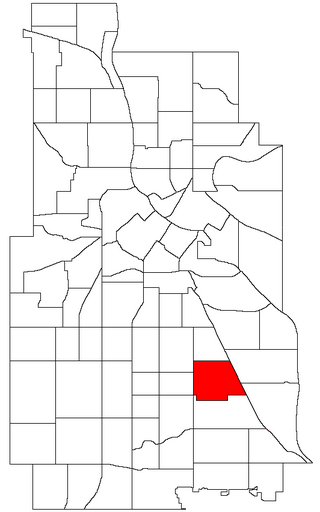
Keewaydin is a neighborhood in the Nokomis community in Minneapolis, Minnesota. Its boundaries are Minnehaha Parkway to the north, 34th Avenue to the east, 54th Street to the south, and Cedar Avenue to the west.
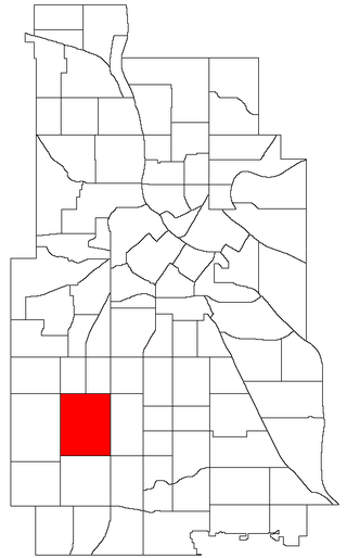
Minnehaha is a neighborhood in the Nokomis community in Minneapolis, Minnesota. Its boundaries are Minnehaha Parkway to the north, Hiawatha Avenue to the east, 54th Street to the south, and 34th Avenue to the west. It is located in Ward 12 of the Minneapolis City Council, currently represented by council member Aurin Chowdhury.

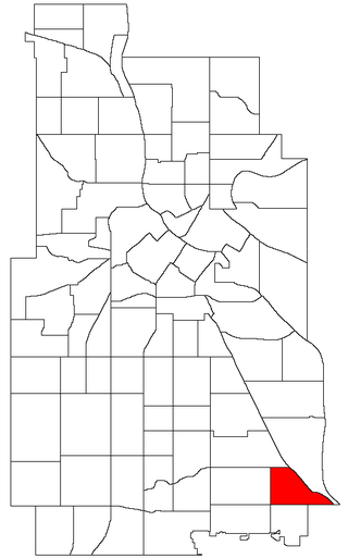
Morris Park is a neighborhood in the Nokomis community in Minneapolis, Minnesota. Its boundaries are 54th Street to the north, 46th Avenue to the east, the Twin Cities Air Force Base to the south, and 34th Avenue to the west. It is located in Ward 12 of the Minneapolis City Council, currently represented by council member Aurin Chowdhury.
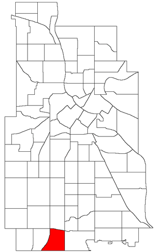
Wenonah is a neighborhood on the southeast side of Minneapolis, Minnesota. Its boundaries are 54th Street to the north, 34th Avenue to the east, the Minneapolis-Saint Paul International Airport to the south, and Cedar Avenue to the west. The neighborhood contains a portion of Lake Nokomis.
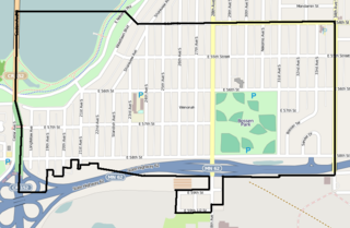
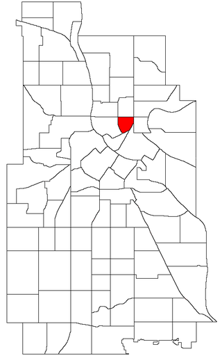
University is a neighborhood within the greater University community in Minneapolis, Minnesota. It is almost completely occupied by the Minneapolis campus of the University of Minnesota, hence the name. It is located entirely within Minneapolis City Council Ward 2, represented by Robin Wonsley.
St. Anthony East is a neighborhood of the Northeast community in Minneapolis. It is located in Ward 3, currently represented by council member Michael Rainville.

Corcoran is a neighborhood within the Powderhorn community in Minneapolis, Minnesota, United States. The neighborhood is bordered by Longfellow and Howe neighborhoods to the east, Phillips to the north, Powderhorn Park to the west and Standish to the south. Its official boundaries are East Lake Street to the north, Hiawatha Avenue to the east, East 36th Street to the south, and Cedar Avenue to the west. It is entirely located within Minneapolis City Council Ward 9, represented by Jason Chavez.
