
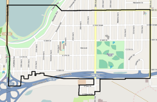
The Seward neighborhood in Minneapolis, Minnesota, United States, is geographically southeast of downtown, consisting of the land bordered by the Hiawatha Avenue industrial district to the west, Minneapolis Midtown Greenway to the south, the Mississippi River to the east, and Interstate 94 to the north. Seward's bordering neighborhoods are Cooper to the southeast, Longfellow to the south, East Phillips to the southwest, Ventura Village to the west, Cedar-Riverside to the north, and Prospect Park/East River Road across the Mississippi River to the east. It is one of the neighborhoods that is part of the larger Longfellow community. Seward was named after former New York senator, governor, and US Secretary of State William H. Seward.

Minneapolis is officially defined by its city council as divided into 83 neighborhoods. The neighborhoods are historically grouped into 11 communities. Informally, there are city areas with colloquial labels. Residents may also group themselves by their city street suffixes, North, Northeast, South, Southeast, and Southwest.
Armatage is a neighborhood in the Southwest community in Minneapolis. In the city's southwest corner, the neighborhood is bounded on the north by 54th Street West, on the east by Logan Avenue South, on the south by Highway 62, and on the west by the city limits at Xerxes Avenue South. Armatage is a part of Ward 13, currently represented by Minneapolis City Council member Linea Palmisano.

Bancroft is a neighborhood within the Powderhorn community in Minneapolis, Minnesota, United States. Its boundaries are East 38th Street to the north, Chicago Avenue to the west, East 42nd Street to the south and Cedar Avenue to the east. It is entirely located within Minneapolis City Council Ward 8, represented by Andrea Jenkins.
Phillips is a community in Minneapolis, just south of downtown. Traditionally, it was both a community and a neighborhood. Phillips is a diverse area in many ways: its population includes people of many nationalities; it has a mix of residential, commercial and industrial uses; and it is home to several large employers such as Abbott Northwestern Hospital, Wells Fargo Mortgage and Allina Health Care Services, along with small neighborhood businesses.
Ventura Village is a neighborhood within the Phillips community in Minneapolis. Its boundaries are Interstate 35W to the west, Interstate 94 to the north, and Hiawatha Avenue to the east. The southern boundary runs along East 22nd Street from I-35W to Chicago Avenue, along East 24th Street from Chicago Avenue to 17th Avenue South, and then back up to 22nd Street from 17th Avenue to Hiawatha Avenue. Franklin Avenue, which runs east–west, acts as the main commercial artery in the neighborhood.

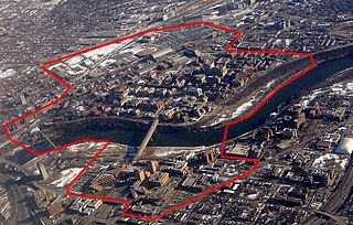
Marcy-Holmes is a neighborhood in the University community of Minneapolis. The majority of the area is residential and sits upon a bluff overlooking the river and the city skyline. A small section of the neighborhood along the river is an industrial zone.

Como is a neighborhood within the University community of Minneapolis. It is sometimes referred to as Southeast Como, due to many of its streets ending in SE, and possibly to differentiate it from the Como neighborhood in neighboring Saint Paul. Its boundaries are East Hennepin Avenue to the north, 33rd Avenue Southeast to the east, the Southeast Industrial Area to the south, and Interstate 35W to the west.

Lyndale is a neighborhood within the Powderhorn community in south Minneapolis, Minnesota, United States. Its boundaries are Lake Street to the north, Interstate 35W to the east, 36th Street to the south and Lyndale Avenue South to the west.
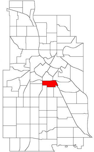
Standish is a neighborhood within the Powderhorn community in Minneapolis, Minnesota, United States named after Captain Miles Standish. Its boundaries are East 36th Street to the north, Hiawatha Avenue to the east, East 42nd and 43rd Streets to the south, and Cedar Avenue to the west.

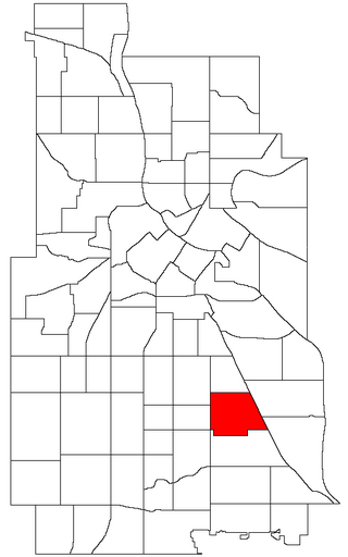
Ericsson is a neighborhood within the Nokomis community in Minneapolis. Its boundaries are East 42nd and 43rd Streets to the north, Hiawatha Avenue to the east, Minnehaha Parkway to the south, and Cedar Avenue to the west. The neighborhood is the site of Lake Hiawatha, which is connected to Minnehaha Creek. Ericsson shares a neighborhood organization with Standish, even though that neighborhood lies in the Powderhorn community; signs at the western, southern, and eastern boundaries of the neighborhood welcome you to "Standish-Ericsson".
East Harriet is a neighborhood in the Southwest community in Minneapolis. Its boundaries are West 36th Street to the north, Lyndale Avenue South to the east, West 46th Street to the south, and Lake Harriet, Lakewood Cemetery, and William Berry Parkway to the west.

Saint Anthony West is a neighborhood in the Northeast community of Minneapolis.

Regina is a neighborhood within the Nokomis community in Minneapolis, Minnesota. Its boundaries are 42nd Street to the north, Chicago Avenue to the east, 46th Street to the south, and Interstate 35W to the west. It shares a neighborhood organization with the Field and Northrop neighborhoods.
Wenonah is a neighborhood on the southeast side of Minneapolis, Minnesota. Its boundaries are 54th Street to the north, 34th Avenue to the east, the Minneapolis-Saint Paul International Airport to the south, and Cedar Avenue to the west. The neighborhood contains a portion of Lake Nokomis. It shares a neighborhood organization with the Keewaydin, Minnehaha, and Morris Park neighborhoods, which are collectively referred to as Nokomis East and are served by the Nokomis East Neighborhood Association (NENA).

Lynnhurst is a neighborhood in the Southwest community in Minneapolis, Minnesota. Its boundaries are 46th Street to the north, Lyndale Avenue to the east, 54th Street to the south, and Penn Avenue to the west. It is located along the southeastern shore of Lake Harriet. Outflows from the lake run through a parkway for several city blocks to reach Minnehaha Creek.
University is a neighborhood within the greater University community in Minneapolis, Minnesota. It is almost completely occupied by the Minneapolis campus of the University of Minnesota, hence the name. It is located entirely within Minneapolis City Council Ward 2, represented by Robin Wonsley.

Powderhorn is a defined community in Minneapolis, that consists of eight neighborhoods. The greater Powderhorn community is named after Powderhorn Park.

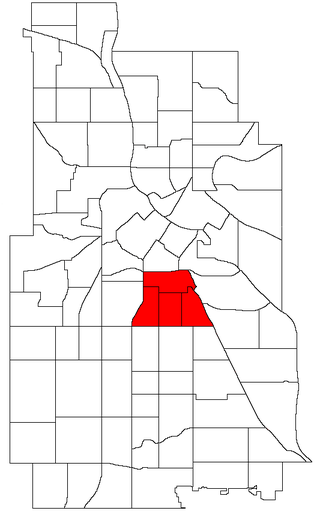
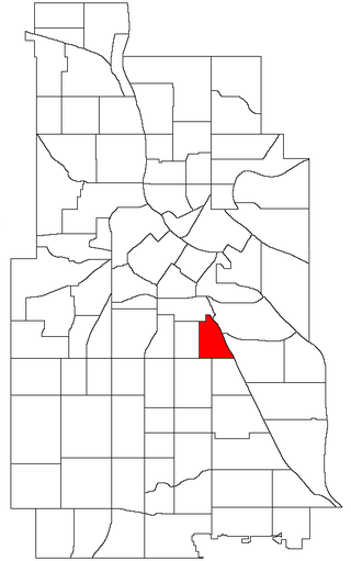
Corcoran is a neighborhood within the Powderhorn community in Minneapolis, Minnesota, United States. The neighborhood is bordered by Longfellow and Howe neighborhoods to the east, Phillips to the north, Powderhorn Park to the west and Standish to the south. Its official boundaries are East Lake Street to the north, Hiawatha Avenue to the east, East 36th Street to the south, and Cedar Avenue to the west. It is entirely located within Minneapolis City Council Ward 9, represented by Jason Chavez.
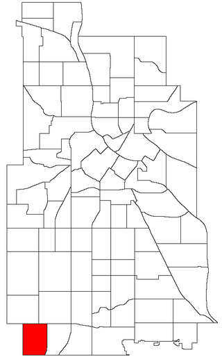
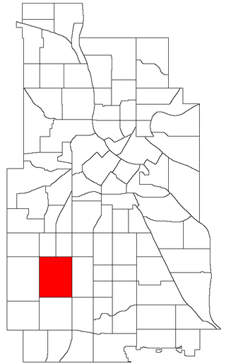
East Phillips is a neighborhood within the Phillips community in Minneapolis. Its northern boundary runs along East 24th Street from Bloomington Avenue to 17th Avenue South, then runs along East 22nd Street from 17th Avenue South to Little Earth Trail and Hiawatha Avenue. Its other boundaries are Hiawatha Avenue to the east, East Lake Street to the south, and Bloomington Avenue to the west. It is a part of Ward 9, currently represented by city council member Jason Chavez.
