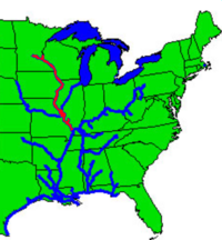
The Mississippi River is the primary river, and second-longest river, of the largest drainage basin in the United States. From its traditional source of Lake Itasca in northern Minnesota, it flows generally south for 2,340 miles (3,766 km) to the Mississippi River Delta in the Gulf of Mexico. With its many tributaries, the Mississippi's watershed drains all or parts of 32 U.S. states and two Canadian provinces between the Rocky and Appalachian mountains. The main stem is entirely within the United States; the total drainage basin is 1,151,000 sq mi (2,980,000 km2), of which only about one percent is in Canada. The Mississippi ranks as the thirteenth-largest river by discharge in the world. The river either borders or passes through the states of Minnesota, Wisconsin, Iowa, Illinois, Missouri, Kentucky, Tennessee, Arkansas, Mississippi, and Louisiana.

The Missouri River is the longest river in the United States. Rising in the eastern Centennial Mountains of the Bitterroot Range of the Rocky Mountains of southwestern Montana, the Missouri flows east and south for 2,341 miles (3,767 km) before entering the Mississippi River north of St. Louis, Missouri. The river drains semi-arid watershed of more than 500,000 square miles (1,300,000 km2), which includes parts of ten U.S. states and two Canadian provinces. Although a tributary of the Mississippi, the Missouri River is slightly longer and carries a comparable volume of water. When combined with the lower Mississippi River, it forms the world's fourth-longest river system.

The Illinois River is a principal tributary of the Mississippi River and is approximately 273 miles (439 km) long. Located in the U.S. state of Illinois, the river has a drainage basin of 28,756.6 square miles (74,479 km2). The Illinois River begins with the confluence of the Des Plaines and Kankakee rivers in the Chicago metropolitan area, and it generally flows to the southwest across Illinois, until it empties into the Mississippi near Grafton, Illinois. Its drainage basin extends into southeastern Wisconsin, northwestern Indiana, and a very small area of southwestern Michigan in addition to central Illinois. Along its shores are several river ports, including Peoria, Illinois. Historic and recreation areas on the river include Starved Rock, and the internationally important wetlands of the Emiquon Complex and Dixon Waterfowl Refuge.

Saint Anthony Falls, or the Falls of Saint Anthony, located at the northeastern edge of downtown Minneapolis, Minnesota, is the only natural major waterfall on the Mississippi River. Throughout the mid-to-late 1800s, various dams were built atop the east and west faces of the falls to support the milling industry that spurred the growth of the city of Minneapolis. In 1880, the central face of the falls was reinforced with a sloping timber apron to stop the upstream erosion of the falls. In the 1950s, the apron was rebuilt with concrete, which makes up the most visible portion of the falls today. A series of locks were constructed in the 1950s and 1960s to extend navigation to points upstream.

The St. Croix River is a tributary of the Mississippi River, approximately 169 miles (272 km) long, in the U.S. states of Wisconsin and Minnesota. The lower 125 miles (201 km) of the river form the border between Wisconsin and Minnesota. The river is a National Scenic Riverway under the protection of the National Park Service. A hydroelectric plant at the Saint Croix Falls Dam supplies power to the Minneapolis–St. Paul metropolitan area.

The White River is a 722-mile (1,162 km) river that flows through the U.S. states of Arkansas and Missouri. Originating in the Boston Mountains of northwest Arkansas, it arcs northwards through southern Missouri before turning back into Arkansas, flowing southeast to its mouth at the Mississippi River.

Glacial Lake Wisconsin was a prehistoric proglacial lake that existed from approximately 18,000 to 14,000 years ago, at the end of the last ice age, in the central part of present-day Wisconsin in the United States.

The Fox–Wisconsin Waterway is a waterway formed by the Fox and Wisconsin Rivers. First used by European settlers in 1673 during the expedition of Marquette & Joliet, it was one of the principal routes used by travelers between the Great Lakes and the Mississippi River until the completion of the Illinois and Michigan Canal in 1848 and the arrival of railroads. The western terminus of the Fox–Wisconsin Waterway was at the Mississippi at Prairie du Chien, Wisconsin. It continued up the Wisconsin River about 116 miles (187 km) until reaching Portage, Wisconsin. There travelers would portage to the Upper Fox River, or eventually, use the Portage Canal. It continued about 160 miles (260 km) down the Fox River, following it through Lake Winnebago and continuing on the Lower Fox over 170 feet of falls to the eastern terminus of Green Bay.

The Driftless Area, also known as Bluff Country and the Paleozoic Plateau, is a topographical and cultural region in the Midwestern United States that comprises southwestern Wisconsin, southeastern Minnesota, northeastern Iowa, and the extreme northwestern corner of Illinois. The Driftless Area is a USDA Level III Ecoregion: Ecoregion 52. The Driftless Area takes up a large portion of the Upper Midwest forest–savanna transition. The Blufflands refers to the eastern section of the Driftless area in Minnesota, due to the steep bluffs and cliffs around the river valleys. The western half is known as the Rochester Plateau, which is flatter than the Blufflands. The Coulee Region refers to the southwestern part of the Driftless Area in Wisconsin. It is named for its numerous ravines.

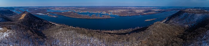
Lake Pepin is a naturally occurring lake on the Mississippi River on the border between the U.S. states of Minnesota and Wisconsin. It is located in a valley carved by the outflow of an enormous glacial lake at the end of the last Ice Age. The lake formed when the Mississippi, a successor to the glacial river, was partially dammed by a delta from a tributary stream and spread out across the ancient valley.

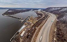
Ford Dam, officially known as Lock and Dam No. 1, is on the Upper Mississippi River and is located between Minneapolis and Saint Paul, Minnesota just north of the confluence of the Mississippi with the Minnesota River at Mississippi River mile 847.9, in Minneapolis. The powerhouse portion was previously owned by the Ford Motor Company, which operated a hydroelectric power station to feed electricity to its Twin Cities Assembly Plant on the east side of the river. It was sold to Brookfield Power Co. in April 2008. The dual-lock facility and dam was built and is operated by the St. Paul district of the U.S. Army Corps of Engineers' Mississippi Valley Division.

The geology of Minnesota comprises the rock, minerals, and soils of the U.S. state of Minnesota, including their formation, development, distribution, and condition.

Chain of Rocks Lock and Dam, also known as Locks No. 27, is a lock situated at the southern end of Chouteau Island near St. Louis, Missouri on the Upper Mississippi River. Its associated dam is just downstream of the Chain of Rocks Bridge, and the lock is located over 3 miles (4.8 km) southeast on the Chain of Rocks canal. The canal and locks allow river traffic to bypass a portion of the river that is unnavigable in low water due to an anticlinal exposure of bedrock in the river—a "chain of rocks".

The Traverse Gap is an ancient river channel occupied by Lake Traverse, Big Stone Lake and the valley connecting them at Browns Valley, Minnesota. It is located on the border of the U.S. states of Minnesota and South Dakota. Traverse Gap has an unusual distinction for a valley: it is crossed by a continental divide, and in some floods, water has flowed across that divide from one drainage basin to the other. Before the Anglo-American Convention of 1818 it marked the border between British territory in the north and U.S. – or earlier, French – territory in the south.
Glacial River Warren, also known as River Warren, was a prehistoric river that drained Lake Agassiz in central North America between about 13,500 and 10,650 BP calibrated years ago. A part of the uppermost portion of the former river channel was designated a National Natural Landmark in 1966.
Floods in the United States before 1900 is a list of flood events that were of significant impact to the country, before 1900. Floods are generally caused by excessive rainfall, excessive snowmelt, and dam failure.
The Water Resources Development Act of 1986 is part of Pub. L.Tooltip Public Law 99–662, a series of acts enacted by Congress of the United States on November 17, 1986.
The Water Resources Development Act of 1992, Pub. L.Tooltip Public Law 102–580, was enacted by Congress of the United States on October 31, 1992. Most of the provisions of WRDA 1992 are administered by the United States Army Corps of Engineers.
The Water Resources Development Act of 2000, Pub. L.Tooltip Public Law 106–541 (text)(PDF), was enacted by Congress of the United States on December 11, 2000. Most of the provisions of WRDA 2000 are administered by the United States Army Corps of Engineers.