
The Manhattan Bridge is a suspension bridge that crosses the East River in New York City, connecting Lower Manhattan at Canal Street with Downtown Brooklyn at the Flatbush Avenue Extension. Designed by Leon Moisseiff and built by the Phoenix Bridge Company, the bridge has a total length of 6,855 ft (2,089 m). It is one of four toll-free vehicular bridges connecting Manhattan Island to Long Island; the nearby Brooklyn Bridge is just slightly farther west, while the Queensboro and Williamsburg bridges are to the north.

Martin Olav Sabo was an American politician who served as United States Representative for Minnesota's fifth district, which includes Minneapolis; the district is one of eight congressional districts in Minnesota.

The Metro Blue Line is a 12-mile (19.3 km) light rail line in Hennepin County, Minnesota, that is part of the Metro network. It travels from downtown Minneapolis to Minneapolis–Saint Paul International Airport and the southern suburb of Bloomington. Formerly the Hiawatha Line prior to May 2013, the line was originally named after the Milwaukee Road's Hiawatha passenger train and Hiawatha Avenue, reusing infrastructure from the former and running parallel to the latter for a portion of the route. The line opened June 26, 2004, and was the first light rail service in Minnesota. An extension, Bottineau LRT, is planned to open in 2028.
Nicollet Mall is a twelve-block portion of Nicollet Avenue running through Downtown Minneapolis, Minnesota, United States. It is a shopping and dining district of the city, and also a pedestrian mall and transit mall. Along with Hennepin Avenue to the west, Nicollet Mall forms the cultural and commercial center of Minneapolis.

URS Corporation was an engineering, design, and construction firm and a U.S. federal government contractor. Headquartered in San Francisco, California, URS was a full-service, global organization with offices located in the Americas, Europe, Africa, and Asia-Pacific.
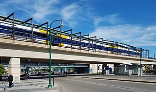
Lake Street/Midtown station, also referred locally as either the Lake Street station or Midtown station, is a Blue Line light rail stop in Minneapolis, Minnesota, United States. The station is located on a bridge over East Lake Street adjacent to Highway 55.

Lake Street is a major east-west thoroughfare between 29th and 31st streets in Minneapolis, Minnesota United States. From its western most end at the city's limits, Lake Street reaches the Chain of Lakes, passing over a small channel linking Bde Maka Ska and Lake of the Isles, and at its eastern most end it reaches the Mississippi River. In May 2020, the Lake Street corridor suffered extensive damage during local unrest following the murder of George Floyd. In August of the same year, city officials designated East Lake Street as one of seven cultural districts to promote racial equity, preserve cultural identity, and promote economic growth.

The Midtown Greenway is a 5.7-mile (9.2 km) rail trail in Minneapolis, Minnesota that follows the path of an abandoned route of the Milwaukee Road railway. It is considered under segregated cycle facilities.

The Short Line Bridge is a truss bridge that spans the Mississippi River in Minneapolis, Minnesota, United States. It was originally built in the 1880s and upgraded a few years later by Chicago, Milwaukee, St. Paul and Pacific Railroad and was designed by American Bridge Company.

The Plymouth Avenue Bridge is a segmental bridge that spans the Mississippi River in Minneapolis. It was built in 1983 and was designed by Van Doren-Hazard-Stallings. The construction of this bridge was unique, for it was the first segmental concrete girder bridge built in Minnesota. This method of design uses a "form traveler" that shapes the concrete as it is built out from the piers. This avoided the use of falsework and avoided impeding river traffic. The concrete is also engineered to be salt-resistant by the use of post-tensioning. Tubes run through the concrete structure carrying strands of cable. With tension on the cables, the structure is designed to be under compression. This prevents cracks and hinders the intrusion of salt water. Since then, other bridges in Minnesota have used this construction method, including the I-35W Saint Anthony Falls Bridge in Minneapolis, the Wabasha Street Bridge in downtown St. Paul, and the Wakota Bridge in South St. Paul.

The Lowry Avenue Bridge is a steel tied-arch bridge over the Mississippi River in Minneapolis, Minnesota, completed in October 2012.

The I-35W Mississippi River bridge was an eight-lane, steel truss arch bridge that carried Interstate 35W across the Mississippi River one-half mile downstream from the Saint Anthony Falls in Minneapolis, Minnesota, United States. The bridge opened in 1967 and was Minnesota's third busiest, carrying 140,000 vehicles daily. It experienced a catastrophic failure during the evening rush hour on August 1, 2007, killing 13 people and injuring 145. The NTSB cited a design flaw as the likely cause of the collapse, noting that an excessively thin gusset plate ripped along a line of rivets, and that additional weight on the bridge at the time contributed to the catastrophic failure.

Longfellow, also referred to as Greater Longfellow is a defined community in Minneapolis, Minnesota which includes five smaller neighborhoods inside of it: Seward, Cooper, Hiawatha, Howe and Longfellow. The community is a mix of agri-industrial properties along the old Northern Pacific Railway, expansive parkland surrounding the famous Minnehaha Falls, and smaller residential areas.

Robert Lilligren is an American politician and member of the Minnesota Democratic-Farmer-Labor Party. He was an elected member of the Minneapolis City Council. He was first elected in 2001, to represent the 8th Ward of the Minneapolis City Council. Following the defeat of Green Party member Dean Zimmermann, during the 2005 municipal elections, Lilligren represented the 6th Ward of the City of Minneapolis. When first elected to office, Lilligren was serving as a volunteer on eight different community boards and commissions including: vice-chair of Phillips West Neighborhood organization, the Midtown Greenway Coalition, the Hennepin County-appointed I-35W Project Advisory Committee, and as a board member for several affordable housing groups throughout South Minneapolis. He lost his re-election bid in 2013 to Abdi Warsame. He was appointed to the Metropolitan Council by Governor Tim Walz in March 2019.

The Kenilworth Trail is a paved bicycle trail in Minneapolis, Minnesota, United States. It runs nearly 1.5 miles (2.4 km) and acts as a connector between the Cedar Lake Trail in the north and the Midtown Greenway in the south. Like the Cedar Lake Trail, most of the route is composed of a triple-divided cycleway/pedway with a pair of one-way paths for bicycles and another path for pedestrians. On some maps, a southern segment of the Kenilworth Trail is called the Burnham Trail. The trail corridor has been considered the most highly trafficked in the Minneapolis park system.

Hiawatha LRT Trail is a 4.7-mile (7.6 km), multi-use path adjacent to a light-rail transit line in Minneapolis, Minnesota, United States, that is popular with bicycle commuters. Users travel along the Metro Blue Line and Hiawatha Avenue transit corridor, reaching downtown Minneapolis near an indoor sports stadium at the trail’s northern end, and reaching a bridge above Minnehaha Creek at the trail’s southern end. Hiawatha LRT Trail provides a vital link between several Minneapolis neighborhoods and the city’s downtown area.

Little Earth Trail is an approximately 1-mile (1.6 km), multi-use bicycle path in Minneapolis, Minnesota, United States, that links several neighborhoods, parks, businesses, and trails in the Phillips community. The trail begins at its northern end near the intersection of East Franklin Avenue and 16th Avenue South and eventually follows the west side of Hiawatha Avenue to the Midtown Greenway and Martin Olav Sabo Bridge. Named after the nearby Little Earth community, the shared-use pathway provides transportation and recreation opportunities, and is a frequent location of activism on social justice issues in Minneapolis.

Min Hi Line is a proposed linear park and shared-use path that would eventually re-purpose an active rail and agri-industrial corridor in the Longfellow community of Minneapolis, Minnesota, United States. Modeled after successful projects like the Atlanta Beltline and New York High Line, it would feature an approximately 3-mile (4.8 km), shared-use pathway that traverses housing, retail, commercial buildings, gardens, playgrounds, and public art installments. Two pilot projects completed in 2018 and 2019 connect the Min Hi Line corridor to trail systems at its northern and southern ends.

Minneapolis is often considered one of the top biking and walking cities in the United States due to its vast network of trails and dedicated pedestrian areas. In 2020, Walk Score rated Minneapolis as 13th highest among cities over 200,000 people. Some bicycling ratings list Minneapolis at the top of all United States cities, while others list Minneapolis in the top ten. There are over 80 miles (130 km) of paved, protected pathways in Minneapolis for use as transportation and recreation. The city's Grand Rounds National Scenic Byway parkway system accounts for the vast majority of the city's shared-use paths at approximately 50 miles (80 km) of dedicated biking and walking areas. By 2008, other city, county, and park board areas accounted for approximately 30 miles (48 km) of additional trails, for a city-wide total of approximately 80 miles (130 km) of protected pathways. The network of shared biking and walking paths continued to grow into the late 2010s with the additions of the Hiawatha LRT Trail gap remediation, Min Hi Line pilot projects, and Samatar Crossing. The city also features several natural-surface hiking trails, mountain-biking paths, groomed cross-country ski trails in winter, and other pedestrian walkways.

The U.S. city of Minneapolis featured officially and unofficially designated camp sites in city parks for people experiencing homelessness that operated from June 10, 2020, to January 7, 2021. The emergence of encampments on public property in Minneapolis was the result of pervasive homelessness, mitigations measures related to the COVID-19 pandemic in Minnesota, local unrest after the murder of George Floyd, and local policies that permitted encampments. At its peak in the summer of 2020, there were thousands of people camping at dozens of park sites across the city. Many of the encampment residents came from outside of Minneapolis to live in the parks. By the end of the permit experiment, four people had died in the city's park encampments, including the city's first homicide victim of 2021, who was stabbed to death inside a tent at Minnehaha Park on January 3, 2021.


