A bike path or a cycle path is a bikeway separated from motorized traffic and dedicated to cycling or shared with pedestrians or other non-motorized users. In the US a bike path sometimes encompasses shared use paths, "multi-use path", or "Class III bikeway" is a paved path that has been designated for use by cyclists outside the right of way of a public road. It may or may not have a center divider or stripe to prevent head-on collisions. In the UK, a shared-use footway or multi-use path is for use by both cyclists and pedestrians.

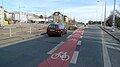
Bike lanes (US) or cycle lanes (UK) are types of bikeways (cycleways) with lanes on the roadway for cyclists only. In the United Kingdom, an on-road cycle-lane can be firmly restricted to cycles or advisory. In the United States, a designated bicycle lane or class II bikeway (Caltrans) is always marked by a solid white stripe on the pavement and is for 'preferential use' by bicyclists. There is also a class III bicycle route, which has roadside signs suggesting a route for cyclists, and urging sharing the road. A class IV separated bike way (Caltrans) is a bike lane that is physically separate from motor traffic and restricted to bicyclists only.

Vehicular cycling is the practice of riding bicycles on roads in a manner that is in accordance with the principles for driving in traffic, and in a way that places responsibility for safety on the individual.

Bicycle transportation planning and engineering are the disciplines related to transportation engineering and transportation planning concerning bicycles as a mode of transport and the concomitant study, design and implementation of cycling infrastructure. It includes the study and design of dedicated transport facilities for cyclists as well as mixed-mode environments and how both of these examples can be made to work safely. In jurisdictions such as the United States it is often practiced in conjunction with planning for pedestrians as a part of active transportation planning.

A bicycle boulevard, sometimes referred to as a neighborhood greenway, neighborway, neighborhood bikeway or neighborhood byway is a type of bikeway composed of a low-speed street which has been "optimized" for bicycle traffic. Bicycle boulevards discourage cut-through motor-vehicle traffic but allow local motor-vehicle traffic. They are designed to give priority to bicyclists as through-going traffic. They are intended as a low-cost, politically popular way to create a connected network of streets with good bicyclist comfort and/or safety.

A subway, also known as an underpass, is a grade-separated pedestrian crossing which crosses underneath a road or railway in order to entirely separate pedestrians and cyclists from motor traffic or trains respectively.

Cycling is the second-most common mode of transport in the Netherlands, with 36% of Dutch people listing the bicycle as their most frequent way of getting around on a typical day, as opposed to the car (45%) and public transport (11%). Cycling has a modal share of 27% of all trips nationwide. In cities this is even higher, such as Amsterdam which has 38%, and Zwolle 46%. This high frequency of bicycle travel is enabled by excellent cycling infrastructure such as cycle paths, cycle tracks, protected intersections, ample bicycle parking and by making cycling routes shorter and more direct than car routes.

A cycle track or cycleway (British) or bikeway, sometimes historically referred to as a sidepath, is a separate route for cycles and not motor vehicles. In some cases cycle tracks are also used by other users such as pedestrians and horse riders. A cycle track can be next to a normal road, and can either be a shared route with pedestrians or be made distinct from both the pavement and general roadway by vertical barriers or elevation differences.

Toronto, Ontario, like many North American cities, has slowly been expanding its purpose-built cycling infrastructure. The number of cyclists in Toronto has been increasing progressively, particularly in the city's downtown core. As cycling conditions improve, a cycling culture has grown and alternatives such as automobiles are seen as less attractive. The politics of providing resources for cyclists, particularly dedicated bike lanes, has been contentious, particularly since the 2010s.

Cycling in Canada is experienced in various ways across a geographically huge, economically and socially diverse country. Among the reasons for cycling in Canada are for practical reasons such as commuting to work or school, for sports such as road racing, BMX, mountain bike racing, freestyle BMX, as well as for pure recreation. The amount and quality of bicycle infrastructure varies widely across the country as do the laws pertaining to cyclists such as bicycle helmet laws which can differ by province.

Cycling infrastructure is all infrastructure cyclists are allowed to use. Bikeways include bike paths, bike lanes, cycle tracks, rail trails and, where permitted, sidewalks. Roads used by motorists are also cycling infrastructure, except where cyclists are barred such as many freeways/motorways. It includes amenities such as bike racks for parking, shelters, service centers and specialized traffic signs and signals. The more cycling infrastructure, the more people get about by bicycle.
The history of cycling infrastructure starts from shortly after the bike boom of the 1880s when the first short stretches of dedicated bicycle infrastructure were built, through to the rise of the automobile from the mid-20th century onwards and the concomitant decline of cycling as a means of transport, to cycling's comeback from the 1970s onwards.

A protected intersection or protected junction, also known as a Dutch-style junction, is a type of at-grade road junction in which cyclists and pedestrians are separated from cars. The primary aim of junction protection is to help pedestrians and cyclists be and feel safer at road junctions.

Controversies have surrounded dedicated cycling routes in cities. Some critics of bikeways argue that the focus should instead be placed on educating cyclists in road safety, and others that safety is better served by using the road space for parking. There is debate over whether cycle tracks are an effective factor to encourage cycling or whether other factors are at play.
Prague was the first city in Czechoslovakia to introduce modern trolleybuses. Only a few other trolleybus systems existed previously in the Czech lands – in České Velenice (Gmünd) and České Budějovice – using the same overhead system as the Electromote, the predecessor of all trolleybuses.

A bicycle highway, also known as a cycling superhighway, fast cycle route or bike freeway, is an informal name for a bicycle path that is meant for long-distance traffic. There is no official definition of a bicycle highway. The characteristics of a cycle motorway mentioned by authorities and traffic experts include an absence of single-level intersections with motorized traffic, a better road surface and the absence of traffic lights. Bicycle highways are mentioned in connection with traffic jam. Owing to higher average speeds than normal cycling infrastructure, they provide an alternative to the car in commuter traffic. Often a cycle motorway follows the route of a railway or other linear infrastructure.
The city of Madrid has been increasing in the last years its network of bicycle paths. In 2016, there were 195 km of cycling routes. The former city council had been planning to build 400 km more for the year 2024 despite a very vocal opposition to the construction of segregated infrastructure by a significant part of the local cycling community. However now with the new right wing mayor elected in 2019 the city is set to be the only capital in the world where bicycle lanes are being removed again.

Rekola is bicycle sharing system in the Czech Republic and Slovakia. It started in Prague in 2013 as a small project of Vít Ježek. As of 2020, it is operating in six Czech cities, Bratislava, the capital of Slovakia and in the Finnish city of Vaasa. The company is operating more than 2000 bikes, most of them are located in Prague. Daily ridership in 2018 was 4,700 people. The pink bikes of Rekola do not have any docks, which makes the system five times cheaper than traditional dock system. The bikes can be unlocked through an official app. User unlocks the bikes manually through the code which is given from the app.

Cycling infrastructure in the Canadian city of Halifax, Nova Scotia includes most regular streets and roads, bike lanes, protected cycle tracks, local street bikeways, and multi-use pathways.

The G Line Bikeway is a cycle route in Los Angeles County, California, that runs for 17.9 miles (28.8 km) and “spans the lengths of the San Fernando Valley’s major communities” from Chatsworth to Valley Glen, “connecting such places as Pierce College, the Sepulveda Basin Recreation Area, the Van Nuys Government Center and Valley College.”