Crosby, Minnesota

Last updated

Crosby
Crosby, Minnesota-01-sign.jpg
Motto: 
Founded by George H. Crosby
Crow Wing County Minnesota Incorporated and Unincorporated areas Crosby Highlighted.svg
Location of Crosby
within Crow Wing County, Minnesota
Coordinates: 46°28′55″N93°57′29″W / 46.48194°N 93.95806°W / 46.48194; -93.95806
Country United States
State Minnesota
County Crow Wing
Area
[1]
  Total3.73 sq mi (9.66 km2)
  Land2.96 sq mi (7.65 km2)
  Water0.77 sq mi (2.01 km2)
Elevation
[2]
1,260 ft (380 m)
Population
 (2020)
  Total2,360
  Density798.65/sq mi (308.31/km2)
Time zone UTC-6 (Central (CST))
  Summer (DST) UTC-5 (CDT)
ZIP code
56441
Area code 218
FIPS code 27-13924 [3]
GNIS feature ID0642478 [2]
Website www.crosbymn.govoffice3.com

Crosby is a city in Crow Wing County, Minnesota, United States. The population was 2,386 at the 2010 census. [4] It is part of the Brainerd Micropolitan Statistical Area. Crosby is adjacent to its twin city of Ironton, in the Cuyuna iron range.

Contents

History

Cuyuna Range Museum Cuyuna Range Museum-Soo Line Depot-04.jpg
Cuyuna Range Museum

Crosby was built for the sole purpose of mining. It was named for George H. Crosby, a businessman in the mining industry. [5]

Crosby was the location of Minnesota's worst mining disaster, the Milford Mine disaster. [6] On February 5, 1924, a new tunnel was blasted too close to nearby Foley Lake, and water rushed in, killing 41 miners.

In the 1932 local elections, Karl Emil Nygard was elected president of Crosby's Village Council, making it the first city in the United States to have a Communist mayor. [7]

In August 1957, David G. Simons, a 35-year-old Air Force major, climbed to nearly 102,000 feet (31,000 m) above the earth as part of Project Manhigh. The flight, which was launched from Crosby's 400-foot-deep (120 m) Portsmouth Mine Pit Lake, helped the United States take its fledgling steps into space exploration. Simons returned to Crosby in 2007 to mark the 50th anniversary of the project. [8]

Geography

This serpent, on the edge of Serpent Lake, welcomes visitors to Crosby, Minnesota. Crosby Serpent.jpg
This serpent, on the edge of Serpent Lake, welcomes visitors to Crosby, Minnesota.

Crosby is in eastern Crow Wing County at the intersection of Minnesota Highways 6 and 210. Ironton is adjacent to the west and Deerwood lies to the east along route 210. Serpent Lake is adjacent to the southeast and the Cuyuna Country State Recreation Area is to the northwest. The Mississippi River flows by four miles to the north. [9]

According to the United States Census Bureau, the city has an area of 3.73 square miles (9.66 km2), of which 3.07 square miles (7.95 km2) is land and 0.66 square miles (1.71 km2) is water. [10]

Demographics

Historical population
CensusPop.Note
1920 3,500
1930 3,451−1.4%
1940 2,954−14.4%
1950 2,777−6.0%
1960 2,629−5.3%
1970 2,241−14.8%
1980 2,218−1.0%
1990 2,073−6.5%
2000 2,29910.9%
2010 2,3863.8%
2020 2,360−1.1%
U.S. Decennial Census

2010 census

As of the census [11] of 2010, there were 2,386 people, 1,065 households, and 552 families living in the city. The population density was 777.2 inhabitants per square mile (300.1/km2). There were 1,241 housing units at an average density of 404.2 per square mile (156.1/km2). The racial makeup of the city was 96.3% White, 0.4% African American, 1.1% Native American, 0.6% Asian, 0.1% from other races, and 1.5% from two or more races. Hispanic or Latino of any race were 1.3% of the population.

There were 1,065 households, of which 27.5% had children under the age of 18 living with them, 32.3% were married couples living together, 13.8% had a female householder with no husband present, 5.7% had a male householder with no wife present, and 48.2% were non-families. 42.3% of all households were made up of individuals, and 22.8% had someone living alone who was 65 years of age or older. The average household size was 2.13 and the average family size was 2.88.

The median age in the city was 43.2 years. 23.3% of residents were under the age of 18; 7.7% were between the ages of 18 and 24; 20.5% were from 25 to 44; 24.3% were from 45 to 64, and 24.2% were 65 years of age or older. The gender makeup of the city was 46.7% male and 53.3% female.

2000 census

As of the census [3] of 2000, there were 2,299 people, 989 households, and 554 families living in the city. The population density was 755.0 inhabitants per square mile (291.5/km2). There were 1,081 housing units at an average density of 355.0 per square mile (137.1/km2). The racial makeup of the city was 97.69% White, 0.04% African American, 0.91% Native American, 0.22% Asian, 0.09% Pacific Islander, 0.35% from other races, and 0.70% from two or more races. Hispanic or Latino of any race were 1.00% of the population. 23.9% were of German, 14.1% Norwegian, 11.7% Swedish, 9.6% American and 7.0% English ancestry according to Census 2000.

There were 989 households, out of which 27.6% had children under the age of 18 living with them, 40.3% were married couples living together, 11.8% had a female householder with no husband present, and 43.9% were non-families. 39.4% of all households were made up of individuals, and 21.2% had someone living alone who was 65 years of age or older. The average household size was 2.18 and the average family size was 2.93.

In the city, the population was spread out, with 24.4% under the age of 18, 8.1% from 18 to 24, 21.9% from 25 to 44, 20.0% from 45 to 64, and 25.6% who were 65 years of age or older. The median age was 42 years. For every 100 females, there were 85.3 males. For every 100 females age 18 and over, there were 79.5 males.

The median income for a household in the city was $24,053, and the median income for a family was $31,629. Males had a median income of $28,879 versus $20,842 for females. The per capita income for the city was $15,465. About 15.6% of families and 16.9% of the population were below the poverty line, including 17.8% of those under age 18 and 12.9% of those age 65 or over.

Notable people

Related Research Articles

<span class="mw-page-title-main">Crow Wing County, Minnesota</span> County in Minnesota, United States

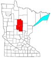
Crow Wing County is a county in the East Central part of the U.S. state of Minnesota. As of the 2020 census, the population was 66,123. Its county seat is Brainerd. The county was formed in 1857, and was organized in 1870.

<span class="mw-page-title-main">East Gull Lake, Minnesota</span> City in Minnesota, United States

East Gull Lake is a city in Cass County, Minnesota, United States. The population was 986 at the 2020 census. The nearest semi-urban area is that of Brainerd and Baxter. It is part of the Brainerd Micropolitan Statistical Area. East Gull Lake is in Central Minnesota's Brainerd Lakes Area and takes its name from the largest lake within its borders, Gull Lake.

<span class="mw-page-title-main">Hackensack, Minnesota</span> City in Minnesota, United States

Hackensack is a city in Cass County, Minnesota, United States. The population was 313 at the 2010 census. It is part of the Brainerd Micropolitan Statistical Area.

<span class="mw-page-title-main">Lake Shore, Minnesota</span> City in Minnesota, United States

Lake Shore is a city in Cass County, Minnesota, United States. The population was 1,056 at the 2020 census. It is part of the Brainerd Micropolitan Statistical Area.

<span class="mw-page-title-main">Baxter, Minnesota</span> City in Minnesota, United States

Baxter is a city in Crow Wing County, Minnesota, United States. The population was 8,612 at the 2020 census. It is part of the Brainerd Micropolitan Statistical Area.

<span class="mw-page-title-main">Brainerd, Minnesota</span> City in Minnesota, United States

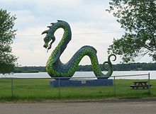
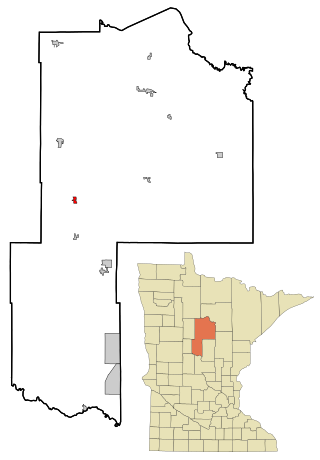
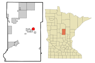
Brainerd is a city in Crow Wing County, Minnesota, United States. Its population was 14,395 at the 2020 census. It is the county seat of Crow Wing County. Brainerd straddles the Mississippi River several miles upstream from its confluence with the Crow Wing River, having been founded as a site for a railroad crossing above the confluence. Brainerd is the principal city of the Brainerd Micropolitan Area, a micropolitan area covering Cass and Crow Wing counties and with a combined population of 96,189 at the 2020 census. The city is well known for being the partial setting of the 1996 film Fargo.

<span class="mw-page-title-main">Breezy Point, Minnesota</span> City in Minnesota, United States

Breezy Point is a city in Crow Wing County, Minnesota, United States. It is part of the Brainerd Micropolitan Statistical Area. The population was 2,346 at the 2010 census.

<span class="mw-page-title-main">Crosslake, Minnesota</span> City in Minnesota, United States

Crosslake is a city in Crow Wing County, Minnesota, United States. The population was 2,141 at the 2010 census. It is part of the Brainerd Micropolitan Statistical Area.

<span class="mw-page-title-main">Cuyuna, Minnesota</span> City in Minnesota, United States

Cuyuna is a city in Crow Wing County, Minnesota, United States. The population was 332 at the 2010 census. It is part of the Brainerd Micropolitan Statistical Area.

<span class="mw-page-title-main">Deerwood, Minnesota</span> City in Minnesota, United States

Deerwood is a city in Crow Wing County, Minnesota, United States. The population was 526 at the 2020 census. It is part of the Brainerd Micropolitan Statistical Area.

<span class="mw-page-title-main">Emily, Minnesota</span> City in Minnesota, United States

Emily is a city in Crow Wing County, Minnesota, United States. The population was 813 at the 2010 census. It is part of the Brainerd Micropolitan Statistical Area.

<span class="mw-page-title-main">Fort Ripley, Minnesota</span> City in Minnesota, United States

Fort Ripley is a city in Crow Wing County, Minnesota, United States, near the confluence of the Mississippi and Nokasippi Rivers. The population was 69 at the 2010 census. It is part of the Brainerd Micropolitan Statistical Area.

<span class="mw-page-title-main">Garrison, Minnesota</span> City in Minnesota, United States

Garrison is a city in Crow Wing County, Minnesota, United States, along Mille Lacs Lake. The population was 210 at the 2010 census. It is part of the Brainerd Micropolitan Statistical Area. U.S. Highway 169 and Minnesota State Highway 18 are the main routes in the community.

<span class="mw-page-title-main">Ironton, Minnesota</span> City in Minnesota, United States

Ironton is a city in Crow Wing County, Minnesota, United States. The population was 572 at the 2010 census. It is part of the Brainerd Micropolitan Statistical Area.

<span class="mw-page-title-main">Jenkins, Minnesota</span> City in Minnesota, United States

Jenkins is a city in Crow Wing County, Minnesota, United States. The population was 430 at the 2010 census. It is part of the Brainerd Micropolitan Statistical Area.

<span class="mw-page-title-main">Nisswa, Minnesota</span> City in Minnesota, United States

Nisswa is a city in Crow Wing County, Minnesota, United States. The population was 1,971 at the 2010 census. Nisswa is part of the Brainerd Micropolitan Statistical Area, near Gull Lake.

<span class="mw-page-title-main">Riverton, Minnesota</span> City in Minnesota, United States

Riverton is a city in Crow Wing County, Minnesota, United States. The population was 117 at the 2010 census. It is part of the Brainerd Micropolitan Statistical Area.

<span class="mw-page-title-main">Trommald, Minnesota</span> City in Minnesota, United States

Trommald is a city in Crow Wing County, Minnesota, United States. The population was 98 at the 2010 census. It is part of the Brainerd Micropolitan Statistical Area.

<span class="mw-page-title-main">Fifty Lakes, Minnesota</span> City in Minnesota, United States

Fifty Lakes is a city in Crow Wing County, Minnesota, United States. The population was 387 at the 2010 census. It is part of the Brainerd Micropolitan Statistical Area.

<span class="mw-page-title-main">Brainerd micropolitan area</span>

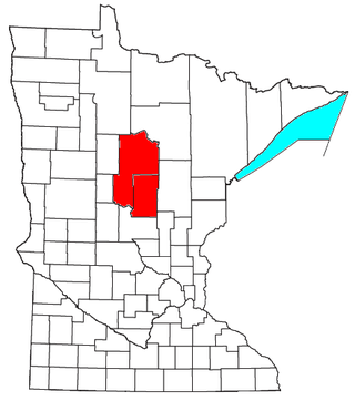
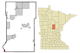
The Brainerd Micropolitan Statistical Area, as defined by the United States Census Bureau, is an area consisting of Cass County and Crow Wing County in Northern Minnesota, anchored by the city of Brainerd. As of July 1, 2022 estimate placed the population at 99,222.

References

  1. "2020 U.S. Gazetteer Files". United States Census Bureau. Retrieved July 24, 2022.
  2. 1 2 U.S. Geological Survey Geographic Names Information System: Crosby, Minnesota
  3. 1 2 "U.S. Census website". United States Census Bureau . Retrieved January 31, 2008.
  4. "2010 Census Redistricting Data (Public Law 94-171) Summary File". American FactFinder. U.S. Census Bureau, 2010 Census. Retrieved April 23, 2011.[ dead link ]
  5. Warren Upham (1920). Minnesota Geographic Names: Their Origin and Historic Significance. Minnesota Historical Society. p.  156.
  6. "Brainerd-Crosby Lakes Area Trail System | Cuyuna Country | Crosby - Ironton | Attractions". Archived from the original on September 7, 2008. Retrieved January 24, 2008.
  7. Donnelly, Thomas (1935). The 1932 Campaign,: An Analysis. Farrar & Rinehart.
  8. "Brainerd Dispatch: Obits | Brainerd, Minnesota | Brainerd Lakes Area Obits on brainerddispatch.com". Archived from the original on April 25, 2010. Retrieved April 22, 2010.
  9. Minnesota Atlas & Gazetteer, Delorme, 9th ed., 2016, p. 54 ISBN   0899333338
  10. "US Gazetteer files 2010". United States Census Bureau. Archived from the original on January 12, 2012. Retrieved November 13, 2012.
  11. "U.S. Census website". United States Census Bureau . Retrieved November 13, 2012.

46°28′56″N93°57′28″W / 46.48222°N 93.95778°W / 46.48222; -93.95778