Lake Shore, Minnesota

Last updated
Lake Shore
Cass County Minnesota Incorporated and Unincorporated areas Lake Shore Highlighted.svg
Location of Lake Shore
within Cass County, Minnesota
Coordinates: 46°30′3″N94°21′27″W / 46.50083°N 94.35750°W / 46.50083; -94.35750
CountryUnited States
State Minnesota
County Cass
Incorporated (village)1930
Incorporated (city)March 19th, 1947
Government
   Mayor John Poston
  CouncilHenry Cote
John Terwilliger
Andy Stewart
Wayne Anderson
Area
[1]
  Total16.00 sq mi (41.44 km2)
  Land12.68 sq mi (32.85 km2)
  Water3.32 sq mi (8.59 km2)
Elevation
1,243 ft (379 m)
Population
 (2020) [2]
  Total1,056
  Estimate 
(2021) [3]
1,090
  Density83.27/sq mi (32.15/km2)
Time zone UTC-6 (Central)
  Summer (DST) UTC-5 (CDT)
ZIP code
56468
Area code 218
FIPS code 27-34928 [4]
GNIS feature ID0646393 [5]
Website cityoflakeshore.com

Lake Shore is a city in Cass County, Minnesota, United States. The population was 1,056 at the 2020 census. [2] It is part of the Brainerd Micropolitan Statistical Area.

Contents

History

Lake Shore was incorporated on March 19, 1947. [6]

Geography

According to the United States Census Bureau, the city has an area of 18.15 square miles (47.01 km2), of which 12.70 square miles (32.89 km2) is land and 5.45 square miles (14.12 km2) is water. [7] County Roads 29, 77, 78, and 107 are the main routes in the community.

Demographics

Historical population
CensusPop.Note
1940 227
1950 32643.6%
1960 264−19.0%
1970 41055.3%
1980 58342.2%
1990 69318.9%
2000 96639.4%
2010 1,0043.9%
2020 1,0565.2%
2021 (est.)1,090 [3] 3.2%
U.S. Decennial Census [8]
2020 Census [2]

2010 census

As of the census of 2010, there were 1,004 people, 451 households, and 322 families living in the city. The population density was 79.1 inhabitants per square mile (30.5/km2). There were 1,019 housing units at an average density of 80.2 per square mile (31.0/km2). The racial makeup of the city was 99.0% White, 0.3% African American, 0.1% Native American, 0.1% Asian, 0.1% from other races, and 0.4% from two or more races. Hispanic or Latino of any race were 0.9% of the population.

There were 451 households, of which 19.3% had children under the age of 18 living with them, 65.4% were married couples living together, 3.1% had a female householder with no husband present, 2.9% had a male householder with no wife present, and 28.6% were non-families. 23.9% of all households were made up of individuals, and 8.7% had someone living alone who was 65 years of age or older. The average household size was 2.23 and the average family size was 2.60.

The median age in the city was 51.5 years. 17.4% of residents were under the age of 18; 3.2% were between the ages of 18 and 24; 19.5% were from 25 to 44; 36.3% were from 45 to 64; and 23.9% were 65 years of age or older. The gender makeup of the city was 52.7% male and 47.3% female.

2000 census

As of the census of 2000, there were 966 people, 436 households, and 327 families living in the city. The population density was 75.5 inhabitants per square mile (29.2/km2). There were 858 housing units at an average density of 67.1 per square mile (25.9/km2). The racial makeup of the city was 98.76% White, 0.41% Native American, 0.10% Asian, 0.10% from other races, and 0.62% from two or more races. Hispanic or Latino of any race were 0.21% of the population.

There were 436 households, out of which 18.3% had children under the age of 18 living with them, 70.0% were married couples living together, 3.0% had a female householder with no husband present, and 25.0% were non-families. 20.6% of all households were made up of individuals, and 7.1% had someone living alone who was 65 years of age or older. The average household size was 2.22 and the average family size was 2.54.

In the city, the population was spread out, with 16.4% under the age of 18, 3.5% from 18 to 24, 22.9% from 25 to 44, 37.6% from 45 to 64, and 19.7% who were 65 years of age or older. The median age was 49 years. For every 100 females, there were 113.7 males. For every 100 females age 18 and over, there were 114.3 males.

The median income for a household in the city was $51,500, and the median income for a family was $56,563. Males had a median income of $41,319 versus $24,688 for females. The per capita income for the city was $33,387. About 2.5% of families and 4.5% of the population were below the poverty line, including 2.6% of those under age 18 and 7.3% of those age 65 or over.

Related Research Articles

<span class="mw-page-title-main">Leary, Georgia</span> City in Georgia, United States

Leary is a city in Calhoun County, Georgia, United States. The population was 618 at the 2010 census. Jimmy Carter reported seeing an unidentified flying object while at Leary, Georgia in 1969.

<span class="mw-page-title-main">Leadore, Idaho</span> City in Idaho, United States

Leadore is an incorporated small town in Lemhi County, Idaho, United States. The population was 105 at the 2010 census.

<span class="mw-page-title-main">Harpers Ferry, Iowa</span> City in Iowa, United States

Harpers Ferry is a city in Taylor Township, Allamakee County, Iowa, United States. The population was 262 at the time of the 2020 census.

<span class="mw-page-title-main">Maynard, Iowa</span> City in Iowa, United States

Maynard is a city in Fayette County, Iowa, United States. The population was 476 at the time of the 2020 census.

<span class="mw-page-title-main">St. Donatus, Iowa</span> City in Iowa, United States

St. Donatus is a city in Jackson County, Iowa, United States. The population was 120 at the time of the 2020 census. St. Donatus is known for its status as a Luxembourger village, with historic architecture and views along U.S. Route 52. It is the home of a historic Catholic church, which is dedicated to Saint Donatus of Muenstereifel, the town's namesake. It was formerly named Tete Des Morts, which is the name of a creek that flows through the village.

<span class="mw-page-title-main">Park, Kansas</span> City in Gove County, Kansas

Park is a city in Gove County, Kansas, United States. As of the 2020 census, the population of the city was 112.

Winn is a town in Penobscot County, Maine, United States, on the east bank of the Penobscot River. The town was named for John M. Winn, an early landholder. The population was 399 at the 2020 census.

<span class="mw-page-title-main">Lilydale, Minnesota</span> City in Minnesota, United States

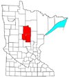
Lilydale is a city in Dakota County, Minnesota, United States. The population was 623 at the 2010 census.

<span class="mw-page-title-main">Wanamingo, Minnesota</span> City in Minnesota, United States

Wanamingo is a community in Goodhue County, Minnesota, United States, incorporated as a city. It lies along the North Fork of the Zumbro River. The population was 1,086 at the 2010 census.

<span class="mw-page-title-main">Erhard, Minnesota</span> City in Minnesota, United States

Erhard is a city in Otter Tail County, Minnesota, United States. The population was 132 at the 2020 census.

<span class="mw-page-title-main">Orr, Minnesota</span> City in Minnesota, United States

Orr is a city in Saint Louis County, Minnesota, United States. The population was 211 at the 2020 census.

<span class="mw-page-title-main">Crystal Lakes, Missouri</span> City in Missouri, United States

Crystal Lakes is a city in western Ray County, Missouri, and part of the Kansas City metropolitan area within the United States. The population was 390 at the 2020 census.

<span class="mw-page-title-main">Flordell Hills, Missouri</span> City in Missouri, United States

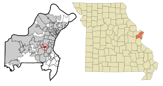
Flordell Hills is a city in St. Louis County, Missouri, United States. The population was 822 at the 2010 census.

<span class="mw-page-title-main">Warson Woods, Missouri</span> City in Missouri, United States

Warson Woods is a city in St. Louis County, Missouri, United States. The population was 1,962 at the 2010 census.

<span class="mw-page-title-main">Westhope, North Dakota</span> City in North Dakota, United States

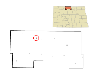
Westhope is a city in Bottineau County, North Dakota, United States. The population was 374 at the 2020 census. Westhope was founded in 1903 along a Great Northern Railway branch line that began in Rugby. The name was based on the slogan "Hope of the West," created by Great Northern officials to promote prosperity for the new town.

<span class="mw-page-title-main">Lincoln, North Dakota</span> City in North Dakota, United States

Lincoln is a city in Burleigh County, North Dakota, United States. It is a suburb of adjacent Bismarck, and also a core city of the Bismarck-Mandan Metropolitan Statistical Area. The population was 4,257 at the 2020 census, making it the fourteenth largest city in North Dakota. Lincoln was founded in 1977.

<span class="mw-page-title-main">Westport, Oklahoma</span> Town in Oklahoma, United States

Westport is a town in Pawnee County, Oklahoma, United States. The population was 298 at the 2010 census, a gain of 12.9 percent over the figure of 264 in 2000.

<span class="mw-page-title-main">Pymatuning Central, Pennsylvania</span> Census-designated place in Pennsylvania, United States

Pymatuning Central is a census-designated place (CDP) in Crawford County, Pennsylvania, United States. The population was 2,269 at the 2010 census.

<span class="mw-page-title-main">Badger, South Dakota</span> Town in South Dakota, United States

Badger is a small town in Kingsbury County, South Dakota, United States. The population was 107 at the 2010 census.

<span class="mw-page-title-main">Bevington, Iowa</span> City in Iowa, United States

Bevington is a city in Madison and Warren Counties in the U.S. state of Iowa. The population was 57 at the 2020 census. It is part of the Des Moines–West Des Moines Metropolitan Statistical Area.

References

  1. "2020 U.S. Gazetteer Files". United States Census Bureau. Retrieved July 24, 2022.
  2. 1 2 3 "Explore Census Data". United States Census Bureau . Retrieved April 14, 2023.
  3. 1 2 "City and Town Population Totals: 2020-2021". United States Census Bureau. March 23, 2023. Retrieved April 14, 2023.
  4. "U.S. Census website". United States Census Bureau . Retrieved January 31, 2008.
  5. "US Board on Geographic Names". United States Geological Survey. October 25, 2007. Retrieved January 31, 2008.
  6. Upham, Warren (2001). Minnesota Place Names: A Geographical Encyclopedia. Minnesota Historical Society Press. p. 95. ISBN   978-0-87351-396-8.
  7. "US Gazetteer files 2010". United States Census Bureau. Archived from the original on July 2, 2012. Retrieved November 13, 2012.
  8. United States Census Bureau. "Census of Population and Housing" . Retrieved September 11, 2013.

Coordinates: 46°29′08″N94°21′38″W / 46.48556°N 94.36056°W / 46.48556; -94.36056