
Cass County is a county in the central part of the U.S. state of Minnesota. As of the 2020 census, the population was 30,066. Its county seat is Walker. The county was formed in 1851, and was organized in 1897.

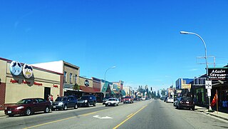
Cass Lake is a city in Cass County, Minnesota, United States, located within the boundaries of the Leech Lake Indian Reservation. It is surrounded by Pike Bay Township. Cass Lake had a population of 675 in the 2020 census. It is notable as the headquarters location of Minnesota Chippewa Tribe and Leech Lake Band of Ojibwe, as well as the Chippewa National Forest.
Turtle Lake Township is a township in Cass County, Minnesota, United States. The population was 699 as of the 2000 census. This township took its name from Turtle Lake.
Shingobee Township is a township in Cass County, Minnesota, United States. The population was 1,745 as of the 2000 census. This township took its name from the Shingobee River.
Walker is a city in Cass County, Minnesota, United States. The population was 941 at the 2010 census. It is the county seat of Cass County.
Wilkinson Township is a township in Cass County, Minnesota, United States. The population was 270 as of the 2000 census.

Leech Lake is a lake located in north central Minnesota, United States. It is southeast of Bemidji, located mainly within the Leech Lake Indian Reservation, and completely within the Chippewa National Forest. It is used as a reservoir. The lake is the third largest in Minnesota, covering 102,947.83 acres (416.6151 km2) with 195 miles (314 km) of shoreline and has a maximum depth of 156 feet (48 m).

The Leech Lake Reservation is an Indian reservation located in the north-central Minnesota counties of Cass, Itasca, Beltrami, and Hubbard. The reservation forms the land base for the federally recognized Leech Lake Band of Ojibwe, one of six bands comprising the Minnesota Chippewa Tribe, organized in 1934. The Leech Lake Reservation has the second highest population of any reservation in Minnesota with White Earth Nation being the largest Minnesota Ojibwe tribe, Leech Lake Nation has a resident population of 11,388 indicated by the 2020 census.

Minnesota State Highway 371 (MN 371) is a 107.411-mile-long (172.861 km) highway in central and north-central Minnesota. The route connects Minnesota's northern lakes region with the central part of the state. It runs south–north from U.S. Highway 10 (US 10) in Little Falls to US 2 in Cass Lake. MN 371 has become a heavily traveled arterial route that was once a two-lane roadway over almost all of its length, but has been widened to four lanes across most of its southern half. Much of the traffic utilizing the route is Twin Cities-based traffic heading to their cabins on one of the many northern lakes.

Chippewa National Forest is a National Forest located in north central Minnesota, United States, in the counties of Itasca, Cass and Beltrami. Forest headquarters are located in Cass Lake, Minnesota. There are local ranger district offices in Blackduck, Deer River and Walker.
Pillager Band of Chippewa Indians are a historical band of Chippewa (Ojibwe) who settled at the headwaters of the Mississippi River in present-day Minnesota. Their name "Pillagers" is a translation of Makandwewininiwag, which literally means "Pillaging Men". The French called them Pilleurs, also a translation of their name. The French and Americans adopted their autonym for their military activities as the advance guard of the Ojibwe in the invasion of the Dakota country.

The Battle of Sugar Point, or the Battle of Leech Lake, was fought on October 5, 1898 between the 3rd U.S. Infantry and members of the Pillager Band of Chippewa Indians in a failed attempt to apprehend Pillager Ojibwe Bugonaygeshig, as the result of a dispute with Indian Service officials on the Leech Lake Reservation in Cass County, Minnesota.
Ball Club is an unincorporated community and census-designated place (CDP) in Itasca County, Minnesota, United States; located within the Leech Lake Indian Reservation. As of the 2010 census, its population was 342. Ball Club is located between Zemple and Bena.
Pennington, also called Cass River, is an unincorporated community in Beltrami County, Minnesota, United States. Pennington is 9.5 miles (15.3 km) northeast of Cass Lake. Pennington has a post office with ZIP code 56663.
Ryan Village is an unincorporated community in Cass County, Minnesota, United States, within the Bowstring State Forest and the Chippewa National Forest. It is located between Cass Lake and Bena along U.S. Highway 2. The village is within the Leech Lake Indian Reservation.
Shingobee Bay is a bay of Leech Lake, Minnesota.
Whipholt is an unincorporated community and census-designated place (CDP) in Pine Lake Township, Cass County, Minnesota, United States, along Leech Lake. Its population was 99 as of the 2010 census. The community is located along State Highway 200 near Pine Lake Road. Whipholt is 13 miles east of Walker.
Onigum is an unincorporated community in Shingobee Township, Cass County, Minnesota, United States, near Walker, along Cass County Road 13. The name Onigum means "portage" in the Ojibwe language.
Wilkinson is an unincorporated community in Wilkinson Township, Cass County, Minnesota, United States, near Cass Lake and Walker. It is located along State Highway 371 near 122nd Street NW.
Raboin is an unincorporated community in Wilkinson Township, Cass County, Minnesota, United States, near Cass Lake and Walker. It is located along State Highway 371 near 134th Street NW.


