
Cass County is a county in the central part of the U.S. state of Minnesota. As of the 2020 census, the population was 30,066. Its county seat is Walker. The county was formed in 1851, and was organized in 1897.
Shingobee Township is a township in Cass County, Minnesota, United States. The population was 1,745 as of the 2000 census. This township took its name from the Shingobee River.
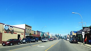
Walker is a city in Cass County, Minnesota, United States. The population was 941 at the 2010 census. It is the county seat of Cass County.

Minnesota State Highway 371 (MN 371) is a 107.411-mile-long (172.861 km) highway in central and north-central Minnesota. The route connects Minnesota's northern lakes region with the central part of the state. It runs south–north from U.S. Highway 10 (US 10) in Little Falls to US 2 in Cass Lake. MN 371 has become a heavily traveled arterial route that was once a two-lane roadway over almost all of its length, but has been widened to four lanes across most of its southern half. Much of the traffic utilizing the route is Twin Cities-based traffic heading to their cabins on one of the many northern lakes.
Togo is an unincorporated community in Carpenter Township, Itasca County, Minnesota, United States.
Twig is an unincorporated community in Grand Lake Township, Saint Louis County, Minnesota, United States.
Saginaw is an unincorporated area in Saint Louis County, Minnesota, United States. Although unincorporated, Saginaw has a post office with the ZIP code 55779.
Soudan is an unincorporated community and census-designated place (CDP) in Breitung Township, Saint Louis County, Minnesota, United States. As of the 2010 census, its population was 446.
Goodland is an unincorporated community in Goodland Township, Itasca County, Minnesota, United States.
Oak Park is an unincorporated community in Maywood Township, Benton County, Minnesota, United States. The community is located along State Highway 23 near Benton County Road 7. Nearby places include Foley, Ronneby, and Foreston.
Centerville is an unincorporated community in Wilson Township, Winona County, Minnesota, United States.
Lake George is an unincorporated community and census-designated place (CDP) in Lake George Township, Hubbard County, Minnesota, United States. As of the 2010 census, its population was 230.
Wannaska is an unincorporated community in Roseau County, Minnesota, United States.

The Minnesota State Sanatorium for Consumptives, also known as the Ah-Gwah-Ching Center, was opened in 1907 to treat tuberculosis patients. The name "Ah-Gwah-Ching" means "out-of-doors" in the Ojibwe language. The center remained a treatment center for tuberculosis until January 1, 1962. During that time, it treated nearly 14,000 patients. In 1962, it became a state nursing home known as the Ah-Gwah-Ching Nursing Home, serving geriatric patients with various mental and physical illnesses. At its peak in the 1970s, the nursing home had as many as 462 patients.
Bass Lake is an unincorporated community in Wirt Township, Itasca County, Minnesota, United States; located within the Chippewa National Forest. The community is located between Wirt and Talmoon at the junction of Itasca County Roads 29 and 127.
Wilkinson is an unincorporated community in Wilkinson Township, Cass County, Minnesota, United States, near Cass Lake and Walker. It is located along State Highway 371 near 122nd Street NW.
Raboin is an unincorporated community in Wilkinson Township, Cass County, Minnesota, United States, near Cass Lake and Walker. It is located along State Highway 371 near 134th Street NW.
Leech Lake is an unincorporated community in Leech Lake Township, Cass County, Minnesota, United States. It is along State Highway 371 near 100th Street NW, Cass County Road 62. Nearby places include Walker, Laporte, and Steamboat Bay of Leech Lake.

Daniel Lee Stevens is an American politician in the state of Minnesota. He served in the Minnesota State Senate.


