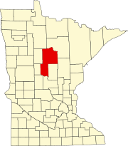
Gould Township, Cass County, Minnesota

Last updated

Gould Township, Minnesota
USA Minnesota location map.svg
Red pog.svg
Gould Township, Minnesota
Location within the state of Minnesota
Usa edcp location map.svg
Red pog.svg
Gould Township, Minnesota
Gould Township, Minnesota (the United States)
Coordinates: 47°11′49″N94°13′48″W / 47.19694°N 94.23000°W / 47.19694; -94.23000
Country United States
State Minnesota
County Cass
Area
  Total44.2 sq mi (114.6 km2)
  Land33.4 sq mi (86.5 km2)
  Water10.8 sq mi (28.0 km2)
Elevation
1,299 ft (396 m)
Population
 (2000)
  Total249
  Density7.5/sq mi (2.9/km2)
Time zone UTC-6 (Central (CST))
  Summer (DST) UTC-5 (CDT)
FIPS code 27-24686 [1]
GNIS feature ID0664302 [2]

Gould Township is a township in Cass County, Minnesota, United States. The population was 249 as of the 2000 census. [3] Gould Township was named for M. I. Gould, a lumberman and local landowner. [4]

Contents

Geography

According to the United States Census Bureau, the township has a total area of 44.2 square miles (114 km2), of which 33.4 square miles (87 km2) is land and 10.8 square miles (28 km2) (24.48%) is water.

The south quarter of the city of Federal Dam is located within Gould Township geographically but is a separate entity.

Lakes

Adjacent townships

Cemeteries

The township contains the following cemeteries: Island Zion and White Cloud.

Demographics

As of the census [1] of 2000, there were 249 people, 95 households, and 66 families residing in the township. The population density was 7.5 people per square mile (2.9/km2). There were 196 housing units at an average density of 5.9/sq mi (2.3/km2). The racial makeup of the township was 38.55% White, 58.23% Native American, and 3.21% from two or more races. Hispanic or Latino of any race were 1.20% of the population.

There were 95 households, out of which 34.7% had children under the age of 18 living with them, 40.0% were married couples living together, 17.9% had a female householder with no husband present, and 29.5% were non-families. 22.1% of all households were made up of individuals, and 8.4% had someone living alone who was 65 years of age or older. The average household size was 2.62 and the average family size was 2.97.

In the township the population was spread out, with 28.5% under the age of 18, 8.4% from 18 to 24, 25.7% from 25 to 44, 24.9% from 45 to 64, and 12.4% who were 65 years of age or older. The median age was 37 years. For every 100 females, there were 99.2 males. For every 100 females age 18 and over, there were 109.4 males.

The median income for a household in the township was $17,813, and the median income for a family was $25,536. Males had a median income of $27,708 versus $17,813 for females. The per capita income for the township was $9,813. About 34.9% of families and 42.8% of the population were below the poverty line, including 58.8% of those under the age of eighteen and 26.3% of those 65 or over.

Related Research Articles

Savannah Township is a township in Becker County, Minnesota, United States. The population was 162 as of the 2000 census.

Durand Township is a township in Beltrami County, Minnesota, United States. The population was 175 as of the 2000 census. Durand Township was named for Charles Durand, an early settler.

Waskish Township is a township in Beltrami County, Minnesota, United States. The population was 116 as of the 2000 census, primarily in the community of Waskish. The community is notable as the only settlement on either Upper or Lower Red Lake not within the boundaries of Red Lake Indian Reservation.

<span class="mw-page-title-main">Artichoke Township, Big Stone County, Minnesota</span> Township in Minnesota, United States

Artichoke Township is a township in Big Stone County, Minnesota, United States. The population was 84 as of the 2000 census. Artichoke is also the name of an unincorporated hamlet within Artichoke Township.

Eagle Township is a township in Carlton County, Minnesota, United States. The population was 565 as of the 2000 census. Eagle Township took its name from Eagle Lake.

<span class="mw-page-title-main">Boy Lake Township, Cass County, Minnesota</span> Township in Minnesota, United States

Boy Lake Township is a township in Cass County, Minnesota, United States. The population was 132 as of the 2000 census. This township took its name from Boy Lake.

Boy River Township is a township in Cass County, Minnesota, United States. The population was 100 as of the 2000 census. This township took its name from the Boy River.

Otter Tail Peninsula Township is a township in Cass County, Minnesota, United States. The population was 43 as of the 2000 census.

Rogers Township is a township in Cass County, Minnesota, United States. The population was 43 as of the 2000 census. Rogers Township was named for William A. Rogers, an early settler.

Turtle Lake Township is a township in Cass County, Minnesota, United States. The population was 699 as of the 2000 census. This township took its name from Turtle Lake.

Freeman Township is a township in Freeborn County, Minnesota, United States. The population was 528 at the 2000 census.

Lake George Township is a township in Hubbard County, Minnesota, United States. The population was 307 at the 2020 census. The unincorporated community and census-designated place of Lake George is located within the township.

Carpenter Township is a township in Itasca County, Minnesota, United States. The population was 179 at the 2010 census.

Lake Jessie Township is a township in Itasca County, Minnesota, United States. The population was 303 at the 2010 census.

Lake Elizabeth Township is a township in Kandiyohi County, Minnesota, United States. The population was 277 at the 2000 census.

Crosby Township is a township in Pine County, Minnesota, United States. The population was 97 at the 2000 census.

Sturgeon Lake Township is a township in Pine County, Minnesota, United States. The population was 409 at the 2000 census.

Lake Johanna Township is a township in Pope County, Minnesota, United States. The population was 151 at the 2000 census.

Beatty Township is a township in Saint Louis County, Minnesota, United States. Beatty Township bears the name of a family of pioneer settlers. The population was 372 at the 2010 census.

Shingobee Township is a township in Cass County, Minnesota, United States. The population was 1,745 as of the 2000 census. This township took its name from the Shingobee River.

References

  1. 1 2 "U.S. Census website". United States Census Bureau . Retrieved January 31, 2008.
  2. "US Board on Geographic Names". United States Geological Survey. October 25, 2007. Retrieved January 31, 2008.
  3. "U.S. Census website" . Retrieved January 2, 2009.
  4. Upham, Warren (1920). Minnesota Geographic Names: Their Origin and Historic Significance. Minnesota Historical Society. p. 89.