
The Sioux or Oceti Sakowin are groups of Native American tribes and First Nations peoples in North America. The modern Sioux consist of two major divisions based on language divisions: the Dakota and Lakota; collectively they are known as the Očhéthi Šakówiŋ. The term "Sioux" is an exonym created from a French transcription ("Nadouessioux") of the Ojibwe term "Nadowessi", and can refer to any ethnic group within the Great Sioux Nation or to any of the nation's many language dialects.

Ronneby is an unincorporated community and census-designated place (CDP) in Maywood Township, Benton County, Minnesota, United States. As of the 2010 census, its population was 67. The community is located along State Highway 23 near Benton County Road 6.
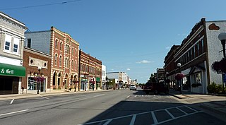
New Ulm is a city in Brown County, Minnesota, United States. The population was 14,120 at the 2020 census. It is the county seat of Brown County. It is located on the triangle of land formed by the confluence of the Minnesota River and the Cottonwood River.

Brooklyn Park is a suburban city on the west bank of the Mississippi River, upstream from downtown Minneapolis in northern Hennepin County. It is the sixth-largest city in the U.S. state of Minnesota. The population was 86,478 at the 2020 census. The city still has undeveloped land and farms, including the historic Eidem Homestead, a 1900s working farm that is a popular tourist attraction for families and school field trips. Brooklyn Park is considered both a second- and third-tier suburb of Minneapolis, because much of the land north of 85th Avenue was developed after 2000.

Eden Prairie is a city 12 miles (19 km) southwest of downtown Minneapolis in Hennepin County and the 16th-largest city in the State of Minnesota, United States. At the 2020 census, it had a population of 64,198. The city is adjacent to the north bank of the Minnesota River, upstream from its confluence with the Mississippi River.

Erskine is a city in Polk County, Minnesota. The population was 403 at the time of the 2020 census. It is part of the Greater Grand Forks region.
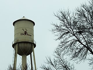
Elk River is a city in Sherburne County, Minnesota, United States, approximately 34 miles northwest of Minneapolis. It is situated at the confluence of the Mississippi and Elk Rivers. The population was 25,835 at the 2020 census, making Elk River the second largest city in the Central Minnesota region after St. Cloud. It is the county seat. U.S. Highways 10 and 169 and State Highway 101 are three of the main routes in Elk River, and a station on the Northstar Commuter Rail line to downtown Minneapolis is located in the city. Elk River is located 33.2 miles northwest of Minneapolis and 37.4 miles southeast of St. Cloud.

Floodwood is a city in Saint Louis County, Minnesota, United States. The population was 528 at the 2010 census.

Hibbing is a city in Saint Louis County, Minnesota, United States. The population was 16,214 at the 2020 census. The city was built on mining the rich iron ore of the Mesabi Iron Range and still relies on that industrial activity today. At the edge of town is the world's largest open-pit iron mine, the Hull–Rust–Mahoning Open Pit Iron Mine. It is the hometown of famous singer Bob Dylan and former Governor of Minnesota Rudy Perpich.
Vermilion Lake Township is a township in Saint Louis County, Minnesota, United States. The population was 278 at the 2010 census.
Oakdale is a city in Washington County, Minnesota, United States. It is a suburb of Saint Paul and is on the eastern side of the Twin Cities Metropolitan area. The population was 28,303 at the 2020 census. Oakdale is the 36th largest city in Minnesota by population.
Woodbury is a city in Washington County, Minnesota, United States, eight miles east of Saint Paul along Interstate 94. It is part of the Minneapolis–Saint Paul metropolitan area. The population was 75,102 at the 2020 census, making it Minnesota's eighth most populous city.

La Crescent is a city in Houston and Winona counties in the U.S. state of Minnesota. The population was 5,276 at the 2020 census.

Princeton is a city in Mille Lacs and Sherburne counties in the U.S. state of Minnesota, at the junction of the Rum River and its West branch. It is 50 miles north of Minneapolis and 30 miles east of St. Cloud, at the intersection of Highways 169 and 95. The population was 4,819 at the 2020 census. A majority of its residents live in Mille Lacs County.

Magnus Johnson was an American politician. He served in the United States Senate and United States House of Representatives from Minnesota as a member of the Farmer–Labor Party. Johnson is the only Swedish-born person to serve in the U.S. Senate.

The Red Lake Indian Reservation covers 1,260.3 sq mi in parts of nine counties in northwestern Minnesota, United States.

Embarrass is an unincorporated community in Embarrass Township, Saint Louis County, Minnesota, United States.
Ash Lake is an unincorporated community in Saint Louis County, Minnesota, United States; located within the Kabetogama State Forest.
Graff is an unincorporated community in Moose Lake Township, Cass County, Minnesota, United States, near Pine River and Pequot Lakes. It is along Cass County Road 24, 64th Street SW, near 51st Avenue SW.
Chamberlain is an unincorporated community in White Oak Township, Hubbard County, Minnesota, United States, near Akeley and Hackensack.


