
Crow Wing County is a county in the U.S. state of Minnesota. As of the 2010 United States Census, the population was 62,500. Its county seat is Brainerd. The county was formed in 1857, and was organized in 1870.

Barclay Township is a township in Cass County, Minnesota, United States. As of the 2000 census, its population was 516. Barclay Township was named for an early settler.
Brainerd is a city in Crow Wing County, Minnesota, United States. Its population was 13,592 as of the 2010 census. It is the county seat of Crow Wing County, and is one of the largest cities in Central Minnesota. Brainerd straddles the Mississippi River several miles upstream from its confluence with the Crow Wing River, having been founded as a site for a railroad crossing above said confluence. Brainerd is the principal city of the Brainerd Micropolitan Area, a micropolitan area covering Cass and Crow Wing counties and with a combined population of 91,067 as of the 2010 census. The Brainerd area serves as a major tourist destination for Minnesota.

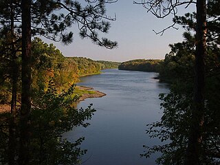
The Crow Wing River is a 113-mile-long (182 km) tributary of the Mississippi River in Minnesota, United States. The river rises at an elevation of about 1391 feet in a chain of 11 lakes in southern Hubbard County, Minnesota, and flows generally south, then east, entering the Mississippi at Crow Wing State Park northwest of Little Falls, Minnesota. Its name is a loose translation from the Ojibwe language Gaagaagiwigwani-ziibi. A wing-shaped island at its mouth accounts for the river's name. Because of its many campsites and its undeveloped shores, the Crow Wing River is considered one of the state's best "wilderness" routes for canoeists; although it is shallow, it is nearly always deep enough for canoeing.
Mille Lacs Indian Reservation is the popular name for the land-base for the Mille Lacs Band of Ojibwe in Central Minnesota, about 100 miles (160 km) north of Minneapolis-St. Paul. The contemporary Mille Lacs Band reservation has significant land holdings in Mille Lacs, Pine, Aitkin and Crow Wing counties, as well as other land holdings in Kanabec, Morrison, and Otter Tail Counties. Mille Lacs Indian Reservation is also the name of a formal Indian reservation established in 1855. It is one of the two formal reservations on which the contemporary Mille Lacs Band retains land holdings. The contemporary Mille Lacs band includes several aboriginal Ojibwe bands and villages, whose members reside in communities throughout central Minnesota.
Crow Wing State Park is a state park of Minnesota, United States, at the confluence of the Mississippi and Crow Wing Rivers. The park interprets the site of Old Crow Wing, one of the most populous towns in Minnesota in the 1850s and 1860s. The entire park was added to the National Register of Historic Places in 1970. A section of the Red River Trails that passed through Old Crow Wing is also separately listed on the National Register.
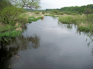
The Shell River is a 47.8-mile-long (76.9 km) tributary of the Crow Wing River in north-central Minnesota in the United States. Via the Crow Wing River, it is part of the watershed of the Mississippi River, draining a rural region.
Merrifield is an unincorporated community and census-designated place (CDP) in Lake Edward Township, Crow Wing County, Minnesota, United States, near Brainerd. It is along Crow Wing County Road 3 near County Road 127. Its population was 140 as of the 2010 census.
Lake Hubert is an unincorporated community in Lake Edward Township, Crow Wing County, Minnesota, United States. Lake Hubert is 2 miles (3.2 km) southeast of Nisswa. It is along Crow Wing County Road 13 near County Road 137. Although it is unincorporated, Lake Hubert has the ZIP code 56459.
The Crow Wing State Forest is a state forest located near Fairfield Township in Crow Wing County, Minnesota. It is about 20 miles (32 km) northeast of the tourism-based town of Brainerd. Approximately 14,072 acres (5,695 ha) (44%) of the forest of 31,307 acres (12,669 ha) is actively managed. The managed acres are split nearly equally between the Minnesota Department of Natural Resources, Crow Wing County, and the privately owned Potlatch Corp.
Crow Wing is an unincorporated community in Crow Wing Township, Crow Wing County, Minnesota, United States, south of Brainerd and Baxter. It is along State Highway 371 near 50th Avenue SW and 85th Street. Crow Wing is three miles northeast of Crow Wing State Park and the former town of Old Crow Wing.
Barrows is an unincorporated community in Crow Wing Township, Crow Wing County, Minnesota, United States, near Brainerd. It is located along Business Highway 371 near Depot Street, Barrows Avenue, and 70th Avenue.
Klondyke is an unincorporated community in Irondale Township, Crow Wing County, Minnesota, United States, near Crosby and Ironton.
Wolford is an unincorporated community in Wolford Township, Crow Wing County, Minnesota, United States, near Crosby. It is along Crow Wing County Road 30 near River Road. State Highway 6 and County Road 11 are both nearby. Perry Lake Township is also in the immediate area.
Swanburg is an unincorporated community in Timothy Township, Crow Wing County, Minnesota, United States. It is along Crow Wing County Road 1 near Swanburg Road. Nearby places include Pine River, Manhattan Beach, and Crosslake.
St. Mathias is an unincorporated community in St. Mathias Township, Crow Wing County, Minnesota, United States. It is along Crow Wing County Road 121 near Hay Creek Road and Sleepy Hollow Road. Nearby places include Fort Ripley, Brainerd, and St. Mathias Park. Hay Creek and the Nokasippi River both flow nearby.
Shephard is an unincorporated community in Daggett Brook Township, Crow Wing County, Minnesota, United States. It is located between Pierz and Brainerd along State Highway 25 at the junction with Crow Wing County Road 2.
Mission is an unincorporated community in Mission Township, Crow Wing County, Minnesota, United States, near Crosby and Merrifield. It is along Crow Wing County Road 11 near Mission Way.
Little Pine is an unincorporated community in Little Pine Township, Crow Wing County, Minnesota, United States, near Emily. It is along Crow Wing County Road 1 near County Road 106. The Little Pine River flows nearby.
Bay Lake is an unincorporated community in Bay Lake Township, Crow Wing County, Minnesota, United States, near Deerwood. It is along State Highway 6 near the junction with Crow Wing County Road 14.


