Maple Plain, Minnesota

Last updated

Maple Plain
Nickname: 
Suplex City
Motto: 
"A Proud Partner Of Active Living Hennepin County"
Hennepin County Minnesota Incorporated and Unincorporated areas Maple Plain Highlighted.svg
Location of Maple Plain
within Hennepin County, Minnesota
Coordinates: 45°0′30″N93°39′32″W / 45.00833°N 93.65889°W / 45.00833; -93.65889
Country United States
State Minnesota
County Hennepin
Government
   Mayor Julie Maas-Kusske
Area
[1]
   City 1.07 sq mi (2.77 km2)
  Land1.06 sq mi (2.76 km2)
  Water0.01 sq mi (0.01 km2)  0.89%
Elevation
1,027 ft (313 m)
Population
 (2020)
   City 1,743
  Density1,636.62/sq mi (632.02/km2)
   Metro
3,279,833
Time zone UTC-6 (Central)
  Summer (DST) UTC-5 (Central)
ZIP code
55359 [2]
Area code 763
FIPS code 27-40256 [3]
GNIS feature ID0647497 [4]
Website www.mapleplain.com

Maple Plain is a city in Hennepin County, Minnesota, United States. The population was 1,768 at the 2010 census. [5]

Contents

History

Maple Plain is named for the many sugar maples in its forests. [6] Settlement of the area began in 1854 and revolved around Lake Independence to its north, and its outflow Pioneer Creek. In 1868 and 1869, the St. Paul, Pacific and Manitoba Railroad was built through Maple Plain. By 1871, Maple Plain had a post office. The city was incorporated as a village in 1912. Village water came to the town in 1939, sewer circa 1950, and blacktop in 1961.

Geography

U.S. Route 12 and Hennepin County Roads 19, 29, and 83 are four of the community's main routes. The city is boarded by Independence to the west.

According to the United States Census Bureau, the city has an area of 1.12 square miles (2.90 km2), of which 1.11 square miles (2.87 km2) is land and 0.01 square miles (0.03 km2) is water. [7] Maple Plain is 20 miles west of Minneapolis on U.S. Highway 12. Pioneer Creek flows through Maple Plain's northwest corner.

Demographics

Maple Plain Library Maple Plain Library.jpg
Maple Plain Library
Historical population
CensusPop.Note
1880 105
1920 273
1930 2885.5%
1940 36025.0%
1950 47933.1%
1960 75457.4%
1970 1,16955.0%
1980 1,42121.6%
1990 2,00541.1%
2000 2,0884.1%
2010 1,768−15.3%
2020 1,743−1.4%
U.S. Decennial Census [8]

2010 census

As of the census [9] of 2010, there were 1,768 people, 723 households, and 462 families living in the city. The population density was 1,592.8 inhabitants per square mile (615.0/km2). There were 775 housing units at an average density of 698.2 per square mile (269.6/km2). The racial makeup of the city was 94.2% White, 2.0% African American, 0.3% Native American, 0.6% Asian, 0.1% Pacific Islander, 1.4% from other races, and 1.4% from two or more races. Hispanic or Latino of any race were 4.8% of the population.

There were 723 households, of which 31.3% had children under the age of 18 living with them, 48.4% were married couples living together, 9.7% had a female householder with no husband present, 5.8% had a male householder with no wife present, and 36.1% were non-families. 29.5% of all households were made up of individuals, and 10.5% had someone living alone who was 65 years of age or older. The average household size was 2.36 and the average family size was 2.94.

The median age in the city was 43.1 years. 22.1% of residents were under the age of 18; 8.3% were between the ages of 18 and 24; 22.7% were from 25 to 44; 33.4% were from 45 to 64; and 13.6% were 65 years of age or older. The gender makeup of the city was 50.0% male and 50.0% female.

2000 census

As of the census [3] of 2000, there were 2,088 people, 770 households, and 536 families living in the city. The population density was 1,875.4 inhabitants per square mile (724.1/km2). There were 786 housing units at an average density of 706.0 per square mile (272.6/km2). The racial makeup of the city was 97.65% White, 0.48% African American, 0.24% Native American, 0.62% Asian, 0.38% from other races, and 0.62% from two or more races. Hispanic or Latino of any race were 0.91% of the population.

There were 770 households, out of which 41.9% had children under the age of 18 living with them, 54.8% were married couples living together, 10.9% had a female householder with no husband present, and 30.3% were non-families. 25.1% of all households were made up of individuals, and 11.0% had someone living alone who was 65 years of age or older. The average household size was 2.61 and the average family size was 3.15.

In the city, the population was spread out, with 28.9% under the age of 18, 7.5% from 18 to 24, 32.3% from 25 to 44, 20.2% from 45 to 64, and 11.2% who were 65 years of age or older. The median age was 36 years. For every 100 females, there were 91.0 males. For every 100 females age 18 and over, there were 88.6 males.

The median income for a household in the city was $50,938, and the median income for a family was $58,977. Males had a median income of $40,114 versus $32,121 for females. The per capita income for the city was $22,218. About 2.6% of families and 4.4% of the population were below the poverty line, including 3.4% of those under age 18 and 10.9% of those age 65 or over.

Government

Presidential election results
2020 Precinct Results Spreadsheet [10] 2016 Precinct Results Spreadsheet [11] 2012 Precinct Results Spreadsheet [12] 2008 Precinct Results Spreadsheet [13] 2004 Precinct Results Spreadsheet [14] 2000 Precinct Results Spreadsheet [15] 1996 Precinct Results [16] 1992 Precinct Results [17] 1988 Precinct Results [18] 1984 Precinct Results [19] 1980 Precinct Results [20] 1976 Precinct Results [21] 1968 Precinct Results [22] 1964 Precinct Results [23] 1960 Precinct Results [24]
Year Republican Democratic Third parties
2020 49.6%52548.4% 5132.0% 21
2016 48.3%48141.2% 41010.5% 104
2012 52.1%55245.8% 4862.1% 22
2008 50.8%51547.5% 4811.7% 17
2004 54.7%56844.2% 4591.1% 12
2000 53.5%54038.5% 3898.0% 81
1996 39.9% 37947.1%44813.0% 124
1992 33.2% 34438.0%39428.8% 298
1988 54.7%52245.3% 4330.0% 0
1984 59.4%47740.6% 3260.0% 0
1980 45.7%35943.8% 34410.5% 82
1976 43.4% 30854.6%3882.0% 14
1968 48.0%23147.8% 2304.2% 20
1964 44.0% 16856.0%2140.0% 0
1960 67.8%24431.7% 1140.5% 2

Notable people

Related Research Articles

Dahlgren Township is a rural township in Carver County, Minnesota, United States. The township's economy is based on commercial agriculture around dairying, livestock and cash grain farming. The population was 1,453 as of the 2000 census.

Laketown Township is a township in Carver County, Minnesota, United States. The population was 2,331 as of the 2000 census.

<span class="mw-page-title-main">Victoria, Minnesota</span> City in Minnesota, United States

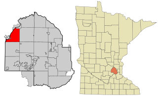
Victoria is a city in Carver County, Minnesota, United States. The population was 10,546 at the 2020 census.

<span class="mw-page-title-main">Manhattan Beach, Minnesota</span> City in Minnesota, United States

Manhattan Beach is a small city in Crow Wing County, Minnesota, United States, near Crosslake. The population was 57 at the 2010 census. It is part of the Brainerd Micropolitan Statistical Area.

<span class="mw-page-title-main">Nisswa, Minnesota</span> City in Minnesota, United States

Nisswa is a city in Crow Wing County, Minnesota, United States. The population was 1,971 at the 2010 census. Nisswa is part of the Brainerd Micropolitan Statistical Area, near Gull Lake.

<span class="mw-page-title-main">Mendota Heights, Minnesota</span> City in Minnesota, United States

Mendota Heights is a city in Dakota County, Minnesota, United States. It is a first-ring southern suburb of the Twin Cities. The population was 11,744 at the 2020 census.

<span class="mw-page-title-main">Greenfield, Minnesota</span> City in Minnesota, United States

Greenfield is a city in northwestern Hennepin County, Minnesota. It has a population of 2,903 residents, according to the 2020 United States Census, and is located 26.5 miles northwest of Minneapolis. It is part of the Twin Cities Metropolitan Statistical Area.

<span class="mw-page-title-main">Tonka Bay, Minnesota</span> City in Minnesota, United States

Tonka Bay is a city in Hennepin County, Minnesota, United States. It is on Lake Minnetonka between the upper and lower lakes. It gained some popularity in the 1880s and 1890s as a summer lake resort. The population was 1,475 at the 2010 census.

<span class="mw-page-title-main">Hallock, Minnesota</span> City in Minnesota, United States

Hallock is a city in and the county seat of Kittson County, Minnesota, United States. The population was 906 at the 2020 census.

<span class="mw-page-title-main">Glencoe, Minnesota</span> City in the United States

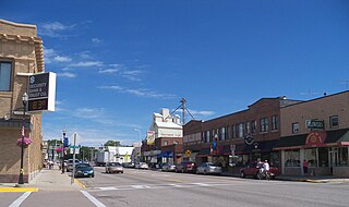
Glencoe is a city and the county seat of McLeod County, Minnesota, United States. The population was 5,744 at the 2020 census.

<span class="mw-page-title-main">Lester Prairie, Minnesota</span> City in Minnesota, United States

Lester Prairie is a city in McLeod County, Minnesota, United States, along the South Fork of the Crow River. The population was 1,894 at the 2020 census.

<span class="mw-page-title-main">Red Lake Falls, Minnesota</span> City in Minnesota, United States

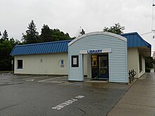
Red Lake Falls is a city and the county seat of Red Lake County, Minnesota, United States. The population was 1,339 at the 2020 census. It is the county seat of Red Lake County. The city lies in the middle of Red Lake Falls Township, from which it was separated when incorporated as a village in 1881. Its status was raised to that of a city in 1898.

<span class="mw-page-title-main">Buhl, Minnesota</span> City in Minnesota, United States

Buhl is a city in Saint Louis County, Minnesota, United States. The population was 952 at the 2020 census.

Rice Lake is a city in Saint Louis County, Minnesota, United States. The population was 4,112 at the 2020 census.

<span class="mw-page-title-main">Wheaton, Minnesota</span> City in Minnesota, United States

Wheaton is a city in Traverse County, Minnesota, United States. The population was 1,460 at the 2020 census. It is the county seat.

<span class="mw-page-title-main">Montrose, Minnesota</span> City in Minnesota, United States

Montrose is a small city in Wright County, Minnesota, United States. Montrose is surrounded by farmland, prairies, and lakes. The population was 2,847 at the 2010 census.

<span class="mw-page-title-main">New Germany, Minnesota</span> City in Minnesota, United States

New Germany is a city in Carver County, Minnesota, United States. The population was 372 at the 2010 census. A large proportion of the early settlers being natives of Germany caused the name to be selected.

<span class="mw-page-title-main">Howard Lake, Minnesota</span> City in Minnesota, United States

Howard Lake is a city in Wright County, Minnesota, United States. It is the host of the annual Wright county fair. The population was 1,962 at the 2010 census.

<span class="mw-page-title-main">Ortonville, Minnesota</span> City in Minnesota, United States

Ortonville is a city and the county seat of Big Stone County in the U.S. state of Minnesota at the southern tip of Big Stone Lake, along the border with South Dakota. The population was 2,021 at the 2020 census. Big Stone Lake State Park is nearby.

<span class="mw-page-title-main">Dayton, Minnesota</span> City in Minnesota, United States

Dayton is a city in Hennepin and Wright counties in the U.S. state of Minnesota. The population was 7,262 at the 2020 census. Dayton is mainly located within Hennepin County, but a part of the city extends into Wright County as well. It is the northernmost city in Hennepin County and is a suburb of the Minneapolis–St. Paul "Twin Cities" metropolitan area.

References

  1. "2020 U.S. Gazetteer Files". United States Census Bureau. Retrieved July 24, 2022.
  2. "Maple Plain MN ZIP Code". zipdatamaps.com. 2024. Retrieved February 5, 2024.
  3. 1 2 "U.S. Census website". United States Census Bureau . Retrieved January 31, 2008.
  4. "US Board on Geographic Names". United States Geological Survey. October 25, 2007. Retrieved January 31, 2008.
  5. "2010 Census Redistricting Data (Public Law 94-171) Summary File". American FactFinder. U.S. Census Bureau, 2010 Census. Retrieved April 23, 2011.[ dead link ]
  6. Upham, Warren (2001). Minnesota Place Names. Minnesota Historical Society Press. p. 229. ISBN   0-87351-396-7. Archived from the original on April 26, 2007.
  7. "US Gazetteer files 2010". United States Census Bureau. Archived from the original on January 25, 2012. Retrieved November 13, 2012.
  8. "Census of Population and Housing". Census.gov. Retrieved June 4, 2016.
  9. "U.S. Census website". United States Census Bureau . Retrieved November 13, 2012.
  10. "Minnesota Secretary of State - 2020 Precinct Results Spreadsheet".
  11. "Minnesota Secretary of State - 2016 Precinct Results Spreadsheet".
  12. "Minnesota Secretary of State - 2012 Precinct Results Spreadsheet".
  13. "Minnesota Secretary of State - 2008 Precinct Results Spreadsheet".
  14. "Minnesota Secretary of State - 2004 Precinct Results Spreadsheet".
  15. "Minnesota Secretary of State - 2000 Precinct Results Spreadsheet".
  16. "1996 Precinct Results" (PDF). Archived (PDF) from the original on April 10, 2021.
  17. "1992 Precinct Results" (PDF). Archived (PDF) from the original on April 10, 2021.
  18. "1988 Precinct Results" (PDF). Archived (PDF) from the original on April 10, 2021.
  19. "1984 Precinct Results" (PDF). Archived (PDF) from the original on April 10, 2021.
  20. "1980 Precinct Results" (PDF). Archived (PDF) from the original on April 10, 2021.
  21. "1976 Precinct Results" (PDF). Archived (PDF) from the original on April 10, 2021.
  22. "1968 Precinct Results" (PDF). Archived (PDF) from the original on April 10, 2021.
  23. "1964 Precinct Results" (PDF).
  24. "1960 Precinct Results" (PDF).
  25. "WWE champ Brock Lesnar unloads 43-acre estate in Minnesota - Los Angeles Times". Los Angeles Times . September 4, 2014.
  26. Rupar, Aaron (June 3, 2014). "Brock Lesnar's $800,000 Maple Plain Home for Sale [Photos]". City Pages . Archived from the original on August 3, 2015.