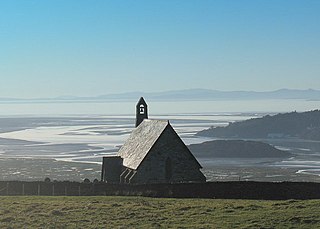
Llanfihangel-y-traethau ("St. Michael's on the Beaches") was a parish in Ardudwy, Gwynedd, north-west Wales centred on a church of the same name in the village of Ynys. The original parish church was built in the 12th century on a tidal island. Later the land rose and connected the island to the mainland. Today it is part of the Bro Ardudwy ministry area, which includes Harlech, a few miles (kilometres) to the southwest, and Barmouth. The church has a window depicting Saint Tecwyn and is the start of the Saint Tecwyn's Way, a pilgrimage route ending at Saint Tecwyn's church in Llandecwyn.[1]
The name means "St. Michael's of the Beaches", and the church was one of several "St. Michael's Mounts" along the shores of the ancient Celtic world, including the famous St Michael's Mount in Cornwall and Mont Saint-Michel in Normandy. The village name, Ynys, means 'island'.[2]
Location
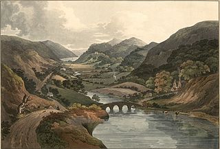
The church of Llanfihangel-y-traethau is half a mile from the coast 3.25 miles (5.23km) north east of Harlech.[3] When the church was built it was on a rocky, tidal island, reached across the sands at low tide or by boat at high tide.[2] (The rivers Glaslyn and Dwyryd once met near Llanfihangel Church, then ran southwest to reach the sea at Harlech.)[4] The sea between Harlech and Ynys retreated in the late Middle Ages, and in 1810 a sea wall was built from Ynys to the 'mainland' near Glan-y-Wern, and another from Glany-Wern to Bont Briwet, the toll bridge to Penrhyndeudraeth. In 1856 plans were made to drain the marshland between Talsarnau and Harlech, to be followed by construction of the lower road (now the main road, the A496) from Talsarnau via Ynys to Harlech.[2]
Formerly the parish included the coast from the mouth of the Afon Glaslyn to the parish of Llandanwg, which included Harlech. The parish included the Penrhyndeudraeth–Portmeirion peninsula across the river.[2] As of 1870 the parish was a sub-district of the Ffestiniog district. The parish covered 7,567 acres (3,062ha) of which 2,656 acres (1,075ha) were water. The land near the river Dwyryd was marshy, although further inland it is hilly, extending as far as the Rhinogs.[3]Penrhyndeudraeth became a separate parish in 1897.[2]
Parish history
Saint Tecwyn, who lived in the early 6th century, came to Britain from Gaul (France) in the time of Vortigern to renew Christianity in Britain.[5] He founded the church in Llandecwyn to the northeast of Ynys.[5] In 1073 a battle was fought near the present village at Bron-yr-Erw between Trahaearn ap Caradog and Gruffudd ap Cynan, two Welsh chieftains.[3][6] The current church of Llanfihangel-y-traethau was established by the mid-12th century. Seagoing vessels were built at Tŷ Gwyn Gamlas near Ynys before the shipyards of Porthmadog were developed. A 1610 map shows the canal from Tŷ Gwyn almost all the way to Harlech Castle.[7]
In the 16th century, Llanfihangel was a chapel of ease for the Llandecwyn parish. A 1623 report says that two or three services are held in Llandecwyn each year, and only one in Llanfihangel. Ellis Wynne of Lasynys Fawr, Rector of Llandanwg and author of Gweledigaethu'r Bardd Cwsg (Visions of the Sleeping Bard), was married in Llanfihangel-y-traethau in 1698. The curate who ministered to the parishes of Llandecwyn and Llanfihangel lived in Tŷ Fry outside Penrhyndeudraeth in the 18th century.[7] The population of the parish in 1801 was 669.[8]
In 1824 plans were published to build a turnpike road from Harlech to the embankment of Traethmawr in the parish. A plan was also made to build a railway from quarries owned by Lord Newborough and others in Ffestiniog parish to the south end of the Traethmawr embankment.[9] Funds were raised in 1834 to build a house for the Rector of Llanfihangel-y-Traethau in Tyddyn Eglwys, near the church.[7] An 1837 gazetteer gave the population as 1,026. The curacy had an annual value of £65.[10] The parish population was 1,587 in 1851 and 1,687 in 1861, with 385 houses, mostly the property of a few landowners.[3] As of 1861 the Ffestiniog workhouse in the parish had 32 inmates.[3]
On 7 May 1858 the Ecclesiastical Commissioners for England proposed to constitute "a separate district for spiritual purposes out of the parishes of Llanfihangel-y-Traethau, Llandecwyn, and Llanfrothen, in the county of Merioneth and in the diocese of Bangor. A sum of £5000 in 3% annuities had been donated by Louisa Jane Oakley, widow, of Plas Tanybwlch, to support the minister of the new district of Penrhyn once it had a parish for ecclesiastical purposes.[11] As of 1868 there was also a district church at Penrhyn Deudraeth and two Methodist chapels.[6]
The Barmouth and Carnarvon railway was completed about the end of 1866, with a station in the parish.[3] In 1927 and again in 1936 the tide overflowed the sea wall and flooded the farmland around Talsarnau. Many animals were drowned and the railway and buildings were badly damaged.[2] The writer and academic Richard Hughes (1900 - 1976) was church warden, and is buried in the churchyard. Today the parish is part of the Bro Ardudwy ministry area, which includes Harlech, a few miles (kilometres) to the southwest, and Barmouth.
Church
Church of Llanfihangel-y-traethau
The graveyard of the church of Llanfihangel-y-traethau has a carved stone about 6 feet (1.8m) high, with a square cross-section of about 0.15 to 0.2 metres (6in to 8in) across.[12] It has a 12th century inscription reading in Latin, after expanding abbreviations,[13]
Hoc (or perhaps Hic) est sepulchrum Wleder matris
Odeleu qui primus edificavit
hanc ecclesiam
in tempore vvini regis
This means, "Here is the grave of Wleder mother of Hoedliw who first built this church in the reign of King Owain".[12] There was some controversy over the names on the stone, and at first it was thought to be the sepulchre of Wledermat Odeleu, but it has come to be accepted that it is the grave of Wleder, mother (matris) of Odeleu.[13]Owain ap Gruffudd was king of Gwynedd from 1137 to 1170, so the stone gives an approximate date for the first church.[12] Over the years the church was altered several times. At one time a small gallery was reserved for "gentlefolk". In 1871 the church was rebuilt, and around 1883 the vestry was added.[2]
Mary Evans (Mari y fantell wen) (1735–89), leader of a sect that claimed she was the bride of Christ, is buried in the graveyard of the church.[14] Many seamen and ship's captains are buried there. Other graves include those of Lewis Holland Thomas, who started as a seafarer and made his fortune as a trader; the author Ann Harriet Hughes (Gwyneth Vaughan, 1852–1910); the diplomat David Ormsby-Gore, 5th Baron Harlech (1918–85); and the author Richard Hughes (1900–76).[7] Hughes spent holidays near Talsarnau as a child and lived near Talsarnau from 1947 until his death. He was churchwarden of Llanfihangel-y-traethau.[15]
Bathurst, William L. (1859), "No. 903—For constituting the District of Penrhyn out of the parishes of Llanfihangel-y-Traethau, Llandecwyn, and Llanfrothen, in the county of Merioneth and in the diocese of Bangor", Reports from Commissioners, retrieved 25 March 2016
Wilson, John Marius (1870–1872), "Llanfihangel Y Traethau Merionethshire", Imperial Gazetteer of England and Wales, retrieved 24 March 2016 Republished by University of Portsmouth as "History of Llanfihangel Y Traethau, in Gwynedd and Merionethshire" in A Vision of Britain through Time
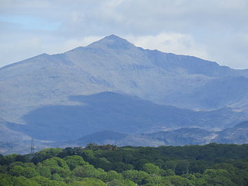
Snowdonia, or Eryri, is a mountainous region and national park in northwestern Wales. It contains all 15 mountains in Wales over 3000 feet high, including the country's highest, Snowdon, which is 1,085 metres (3,560 ft) tall. These peaks are all part of the Snowdon, Glyderau, and Carneddau ranges in the north of the region. The shorter Moelwynion and Moel Hebog ranges lie immediately to the south.
Merionethshire or Merioneth is one of thirteen historic counties of Wales, a vice county and a former administrative county.
Penrhyndeudraeth is a small town and community in the Welsh county of Gwynedd. The town is close to the mouth of the River Dwyryd on the A487 nearly 3 miles (4.8 km) east of Porthmadog, and had a population of 2,150 at the 2011 census, increased from 2,031 in 2001. The community includes the villages of Minffordd and Portmeirion.
Ellis Wynne was a Welsh clergyman and author. He is remembered mainly for one of the most important and influential pieces of Welsh-language literature.
Maentwrog is a village and community in the Welsh county of Merionethshire, lying in the Vale of Ffestiniog just below Blaenau Ffestiniog, within the Snowdonia National Park. The River Dwyryd runs alongside the village. Its population of 585 in 2001 increased to 631 at the 2011 Census. The Community of Maentwrog includes the village of Gellilydan.
The LL postcode area, also known as the Llandudno postcode area, is a group of 67 postcode districts, within 62 post towns. These cover the majority of north Wales, plus a very small part of west Wales and the English county of Shropshire. The districts start at LL11 so as to avoid confusion with Liverpool postcodes.
Ann Harriet Hughes was a Welsh language novelist, under the pen-name Gwyneth Vaughan.
Dyffryn Ardudwy is a village, community and electoral ward in the Ardudwy area of Gwynedd, Wales. It comprises several small, almost conjoined, villages including Coed Ystumgwern, Llanenddwyn, Llanddwywe, Talybont and Dyffryn Ardudwy. It is situated on the main A496 coast road between Harlech and Barmouth. The ward had a population of 1,540 according to the 2011 census.
Talsarnau is a village and community in the Ardudwy area of Gwynedd in Wales. Its population was 525 in 2001, and had increased to 550 at the 2011 Census.
Saint Tecwyn is the patron saint and founder of Llandecwyn in the Welsh county of Gwynedd.
The A496 is a major coastal and mountainous road in southern Snowdonia.
Eisingrug is a rural hamlet near Harlech, Gwynedd, Wales. It is located to the southeast of Porthmadog.
Llandecwyn is a hamlet near Penrhyndeudraeth in Gwynedd, Wales.
The Diocese of Bangor is a diocese of the Church in Wales in North West Wales. The diocese covers the counties of Anglesey, most of Caernarfonshire and Merionethshire and the western part of Montgomeryshire.
Mary Evans, known as Mari y fantell wen was the leader of a short-lived religious sect in Wales whose followers held that she was married to Christ and would never die. The sect soon dissolved after her death.
Ysgol Ardudwy is a bilingual secondary school for 11–16 year olds at Harlech, Gwynedd, Wales. It serves the seaside communities of Penrhyndeudraeth, Harlech, Abermaw (Barmouth) and nearby villages. It had 316 pupils on the roll in 2022.
Bro Ardudwy is a Ministry Area of the Church in Wales which is part of the Diocese of Bangor. It is located within the Meirionydd Synod.
This page is based on this Wikipedia article Text is available under the CC BY-SA 4.0 license; additional terms may apply. Images, videos and audio are available under their respective licenses.