
Longitude is a geographic coordinate that specifies the east–west position of a point on the surface of the Earth, or another celestial body. It is an angular measurement, usually expressed in degrees and denoted by the Greek letter lambda (λ). Meridians are imaginary semicircular lines running from pole to pole that connect points with the same longitude. The prime meridian defines 0° longitude; by convention the International Reference Meridian for the Earth passes near the Royal Observatory in Greenwich, south-east London on the island of Great Britain. Positive longitudes are east of the prime meridian, and negative ones are west.

Navigation is a field of study that focuses on the process of monitoring and controlling the movement of a craft or vehicle from one place to another. The field of navigation includes four general categories: land navigation, marine navigation, aeronautic navigation, and space navigation.
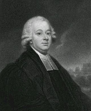
Nevil Maskelyne was the fifth British Astronomer Royal. He held the office from 1765 to 1811. He was the first person to scientifically measure the mass of the planet Earth. He created the British Nautical Almanac and Astronomical Ephemeris for the Meridian of the Royal Observatory at Greenwich using Tobias Mayer's corrections for Euler's Lunar Theory tables.

The longitude rewards were the system of inducement prizes offered by the British government for a simple and practical method for the precise determination of a ship's longitude at sea. The rewards, established through an Act of Parliament in 1714, were administered by the Board of Longitude.

The Commissioners for the Discovery of the Longitude at Sea, or more popularly Board of Longitude, was a British government body formed in 1714 to administer a scheme of prizes intended to encourage innovators to solve the problem of finding longitude at sea.

Celestial navigation, also known as astronavigation, is the practice of position fixing using stars and other celestial bodies that enables a navigator to accurately determine their actual current physical position in space or on the surface of the Earth without relying solely on estimated positional calculations, commonly known as "dead reckoning." Celestial navigation is performed without using satellite navigation or other similar modern electronic or digital positioning means.
In astronomical navigation, the intercept method, also known as Marcq St. Hilaire method, is a method of calculating an observer's position on Earth (geopositioning). It was originally called the azimuth intercept method because the process involves drawing a line which intercepts the azimuth line. This name was shortened to intercept method and the intercept distance was shortened to 'intercept'.

Longitude by chronometer is a method, in navigation, of determining longitude using a marine chronometer, which was developed by John Harrison during the first half of the eighteenth century. It is an astronomical method of calculating the longitude at which a position line, drawn from a sight by sextant of any celestial body, crosses the observer's assumed latitude. In order to calculate the position line, the time of the sight must be known so that the celestial position i.e. the Greenwich Hour Angle and Declination, of the observed celestial body is known. All that can be derived from a single sight is a single position line, which can be achieved at any time during daylight when both the sea horizon and the sun are visible. To achieve a fix, more than one celestial body and the sea horizon must be visible. This is usually only possible at dawn and dusk.
Ex-meridian is a celestial navigation method of calculating an observer's position on Earth. The method gives the observer a position line on which the observer is situated. It is usually used when the Sun is obscured at noon, and as a result, a meridian altitude is not possible. The navigator measures the altitude of the Sun as close to noon as possible and then calculates where the position line lies.
Meridian altitude is a method of celestial navigation to calculate an observer's latitude. It notes the altitude angle of an astronomical object above the horizon at culmination.

In celestial navigation, lunar distance, also called a lunar, is the angular distance between the Moon and another celestial body. The lunar distances method uses this angle and a nautical almanac to calculate Greenwich time if so desired, or by extension any other time. That calculated time can be used in solving a spherical triangle. The theory was first published by Johannes Werner in 1524, before the necessary almanacs had been published. A fuller method was published in 1763 and used until about 1850 when it was superseded by the marine chronometer. A similar method uses the positions of the Galilean moons of Jupiter.
The navigational triangle or PZX triangle is a spherical triangle used in astronavigation to determine the observer's position on the globe. It is composed of three reference points on the celestial sphere:

A marine chronometer is a precision timepiece that is carried on a ship and employed in the determination of the ship's position by celestial navigation. It is used to determine longitude by comparing Greenwich Mean Time (GMT), and the time at the current location found from observations of celestial bodies. When first developed in the 18th century, it was a major technical achievement, as accurate knowledge of the time over a long sea voyage was vital for effective navigation, lacking electronic or communications aids. The first true chronometer was the life work of one man, John Harrison, spanning 31 years of persistent experimentation and testing that revolutionized naval navigation.

The history of navigation, or the history of seafaring, is the art of directing vessels upon the open sea through the establishment of its position and course by means of traditional practice, geometry, astronomy, or special instruments. Many peoples have excelled as seafarers, prominent among them the Austronesians, the Harappans, the Phoenicians, the Iranians, the ancient Greeks, the Romans, the Arabs, the ancient Indians, the Norse, the Chinese, the Venetians, the Genoese, the Hanseatic Germans, the Portuguese, the Spanish, the English, the French, the Dutch, and the Danes.
The mariner's astrolabe, also called sea astrolabe, was an inclinometer used to determine the latitude of a ship at sea by measuring the sun's noon altitude (declination) or the meridian altitude of a star of known declination. Not an astrolabe proper, the mariner's astrolabe was rather a graduated circle with an alidade used to measure vertical angles. They were designed to allow for their use on boats in rough water and/or in heavy winds, which astrolabes are ill-equipped to handle. It was invented by the Portuguese people, a nation known for its maritime prowess and dominated the sea for multiple centuries. In the sixteenth century, the instrument was also called a ring.

The history of longitude describes the centuries-long effort by astronomers, cartographers and navigators to discover a means of determining the longitude of any given place on Earth. The measurement of longitude is important to both cartography and navigation. In particular, for safe ocean navigation, knowledge of both latitude and longitude is required, however latitude can be determined with good accuracy with local astronomical observations.

Longitude: The True Story of a Lone Genius Who Solved the Greatest Scientific Problem of His Time is a best-selling book by Dava Sobel about John Harrison, an 18th-century clockmaker who created the first clock (chronometer) sufficiently accurate to be used to determine longitude at sea—an important development in navigation. The book was made into a television series entitled Longitude. In 1998, The Illustrated Longitude was published, supplementing the earlier text with 180 images of characters, events, instruments, maps and publications.

The Scilly naval disaster of 1707 was the loss of four warships of a Royal Navy fleet off the Isles of Scilly in severe weather on 22 October 1707. Between 1,400 and 2,000 sailors lost their lives aboard the wrecked vessels, making the incident one of the worst maritime disasters in British naval history. The disaster has been attributed to a combination of factors, including the navigators' inability to accurately calculate their positions, errors in the available charts and pilot books, and inadequate compasses.
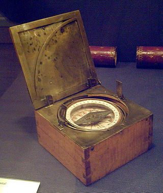
An azimuth compass is a nautical instrument used to measure the magnetic azimuth, the angle of the arc on the horizon between the direction of the Sun or some other celestial object and the magnetic north. This can be compared to the true azimuth obtained by astronomical observation to determine the magnetic declination, the amount by which the reading of a ship's compass must be adjusted to obtain an accurate reading. Azimuth compasses were important in the period before development of the reliable chronometers needed to determine a vessel's exact position from astronomical observations.
Robert Waddington was a mathematician, astronomer and teacher of navigation. He is best known as one of the observers appointed by the Royal Society to observe the 1761 transit of Venus with Nevil Maskelyne on the island of Saint Helena. On that voyage they made successful use of the lunar-distance method of establishing longitude at sea. Waddington subsequently taught the method at his academy in London and published a navigation manual, A Practical Method for Finding the Longitude and Latitude of a Ship at Sea, by Observations of the Moon (1763).


