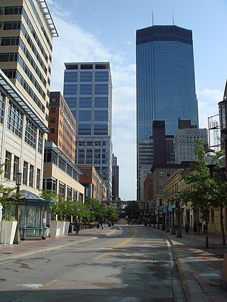
Nicollet Mall is a twelve-block portion of Nicollet Avenue running through downtown Minneapolis, Minnesota, United States. It is the shopping and dining district of the city, and also a pedestrian mall and transit mall. Along with Hennepin Avenue to the west, Nicollet Mall forms the cultural and commercial center of Minneapolis.

Nicollet Avenue is a major street in Minneapolis, Richfield, Bloomington, and Burnsville in the U.S. state of Minnesota. It passes through a number of locally well-known neighborhoods and districts, notably Eat Street in south Minneapolis and the traffic-restricted Nicollet Mall in downtown Minneapolis.

Orchestra Hall is a concert hall that is located on 11th Street at Peavey Plaza in downtown Minneapolis, Minnesota. The home of the Minnesota Orchestra, it is a major landmark of the southern portion of Nicollet Mall and hosts many events throughout the year, in addition to being the Orchestra's home.

The U.S. city of Minneapolis is officially defined by the Minneapolis City Council as divided into eleven communities, each containing multiple official neighborhoods. Informally, there are city areas with colloquial labels. Residents may also group themselves by their city street suffixes, North, Northeast, South, Southeast, and Southwest.

Lake Street is a major east-west thoroughfare between 29th and 31st streets in Minneapolis, Minnesota United States. From its western most end at the city's limits, Lake Street reaches the Chain of Lakes, passing over a small channel linking Bde Maka Ska and Lake of the Isles, and at its eastern most end it reaches the Mississippi River. In May 2020, the Lake Street corridor suffered extensive damage during local unrest over the death of George Floyd. In August of the same year, city officials designated East Lake Street as one of seven cultural districts to promote racial equity, preserve cultural identity, and promote economic growth.
M. Paul Friedberg, FASLA, is an American landscape architect.

Loring Park is a neighborhood in the Central Community of Minneapolis, Minnesota. Located on the southwest corner of downtown Minneapolis, it also lends its name to Loring Park, the largest park in the neighborhood. The official boundaries of the neighborhood are Lyndale Avenue to the west, Interstate 394 to the north, 12th Street to the northeast, Highway 65 to the east, and Interstate 94 to the south.

Downtown West is an official neighborhood in Minneapolis, part of the larger Central community. It is the heart of downtown Minneapolis, containing the bulk of high-rise office buildings in the city, and is what comes to mind when most Minneapolitans think of "downtown".

Downtown East is an official neighborhood in Minneapolis, Minnesota, United States. Within Downtown East is the Mill District, which contains former industrial buildings left over from the days when Minneapolis was the flour milling capital of the world. Many of these old mills and factories are being converted to housing, bringing a residential population to a neighborhood that beforehand didn't have many residents. Because of this, the Mill District in Downtown East is one of the fastest growing areas of the city.

Robert Lilligren is an American politician and member of the Minnesota Democratic-Farmer-Labor Party. He was an elected member of the Minneapolis City Council. He was first elected in 2001, to represent the 8th Ward of the Minneapolis City Council. Following the defeat of Green Party member Dean Zimmermann, during the 2005 municipal elections, Lilligren represented the 6th Ward of the City of Minneapolis. When first elected to office, Lilligren was serving as a volunteer on eight different community boards and commissions including: vice-chair of Phillips West Neighborhood organization, the Midtown Greenway Coalition, the Hennepin County-appointed I-35W Project Advisory Committee, and as a board member for several affordable housing groups throughout South Minneapolis. He lost his re-election bid in 2013 to Abdi Warsame. He was appointed to the Metropolitan Council by Governor Tim Walz in March 2019.
The Minneapolis Streetcar System was a proposed streetcar system for the city of Minneapolis, Minnesota. Extensive studies and plans for the new system were completed in 2007 and presented to the Minneapolis City Council in January 2008; on April 2, 2010, the Council voted to approve the plans and seek funding. On December 21, 2010 the Federal Transit Administration granted $900,000 to further study the Nicollet and Central Avenue corridors. In June 2021, after no further development on the system, a bill authorized the Metropolitan Council to use funds collected for the Nicollet-Central line to be spent on bus rapid transit funding.


The Great Rivers Greenway District is a public agency created in 2000 to develop a regional network of greenways. Great Rivers Greenway engages citizens and community partners to plan, build and care for the greenways. In its first 20 years the agency built more than 128 miles of greenways connecting parks, rivers, schools, neighborhoods, business districts and transit.
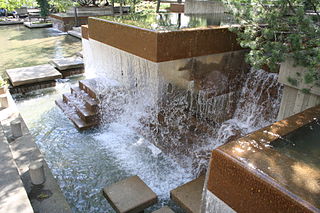
Peavey Plaza is a park plaza that serves as a public outdoor space in downtown Minneapolis, Minnesota at the south end of Nicollet Mall between South 11th and 12th Streets. The sunken plaza and its amphitheater were designed by landscape architect M. Paul Friedberg and built in 1975 alongside Orchestra Hall. The Cultural Landscape Foundation has deemed the plaza a "marvel of modernism" and it was named one of the top ten most endangered historical sites in Minnesota before its rehabilitation in 2019.

Minneapolis City Center is a mixed-use shopping mall on Nicollet Mall in Minneapolis, Minnesota. It opened in 1983 and occupies the bottom three floors of the 33 South Sixth office building. Designed by Skidmore, Owings & Merrill, Minneapolis City Center contains 250,000 square feet (23,000 m2) of leasable retail space. The mall was built around the pre-existing Forum Cafeteria restaurant. The building is adjacent to the Marriott Hotel City Center and connected to the Gaviidae Common shopping mall.

Hiawatha LRT Trail is a 4.7-mile (7.6 km), multi-use path adjacent to a light-rail transit line in Minneapolis, Minnesota, United States, that is popular with bicycle commuters. Users travel along the Metro Blue Line and Hiawatha Avenue transit corridor, reaching downtown Minneapolis near an indoor sports stadium at the trail’s northern end, and reaching a bridge above Minnehaha Creek at the trail’s southern end. Hiawatha LRT Trail provides a vital link between several Minneapolis neighborhoods and the city’s downtown area.

Minneapolis is often considered one of the top biking and walking cities in the United States due to its vast network of trails and dedicated pedestrian areas. In 2020, Walk Score rated Minneapolis as 13th highest among cities over 200,000 people. Some bicycling ratings list Minneapolis at the top of all United States cities, while others list Minneapolis in the top ten. There are over 80 miles (130 km) of paved, protected pathways in Minneapolis for use as transportation and recreation. The city's Grand Rounds National Scenic Byway parkway system accounts for the vast majority of the city's shared-use paths at approximately 50 miles (80 km) of dedicated biking and walking areas. By 2008, other city, county, and park board areas accounted for approximately 30 miles (48 km) of additional trails, for a city-wide total of approximately 80 miles (130 km) of protected pathways. The network of shared biking and walking paths continued to grow into the late 2010s with the additions of the Hiawatha LRT Trail gap remediation, Min Hi Line pilot projects, and Samatar Crossing. The city also features several natural-surface hiking trails, mountain-biking paths, groomed cross-country ski trails in winter, and other pedestrian walkways.

The Marq2 transit corridor is a north–south thoroughfare in Minneapolis, Minnesota, United States. It consists of the parallel streets of Marquette and Second avenues in the downtown area. Each public streetway has two contraflow bus lanes with two lanes available for general-purpose traffic in the opposite direction. Vehicular transit flows south on Marquette Avenue and north on Second Avenue. The inner curb lane allows buses to stop for riders, while the second bus-only lane allows buses to pass each other along the corridor. Bus routes that operate on the corridor stop at every other block at an assigned gate with each route assigned a northbound and southbound gate. Gates are assigned letters A, B, C, or D on Marquette Avenue and E, F, G, and H on Second Avenue. Custom bus shelters are installed at each stop with heaters and real time transit information. The corridor primarily serves express buses operated by all five public transit agencies in the Twin Cities.
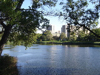
Loring Park is a park in the Loring Park neighborhood of Minneapolis, Minnesota.

Charles A. Birnbaum is a nationally recognized advocate for the study of American landscapes. He is the President and CEO of The Cultural Landscape Foundation (TCLF) in Washington, DC.

