Los Cerritos Wetlands

Last updated

Los Cerritos Wetlands, Zedler Marsh ZedlerMarsh.jpg
Los Cerritos Wetlands, Zedler Marsh

Los Cerritos Wetlands is located in both Los Angeles County and Orange County in the cities of Long Beach, California, and Seal Beach, California. The San Gabriel River, historically and currently flows through the Los Cerritos Wetlands Complex. [1]

Contents

Los Cerritos Wetlands is very close to the Pacific Ocean with waters at high tides bringing shallow ocean water over portions of the marshland. Some portions of Los Cerritos Wetlands are fed by winter rainfall creating ephemeral pools.

Once a vast marsh covering approximately 2,400 acres (971 ha), Los Cerritos Wetland are now smaller but still maintain ecological function and ecosystem processes. They were historically the wetlands of Puvunga. [2]

Environment and wildlife

Los Cerritos Wetlands, Steamshovel Slough SteamShovelSlough.jpg
Los Cerritos Wetlands, Steamshovel Slough

Los Cerritos Wetlands consists of two functioning marshes (Steamshovel Slough and Zedler Marsh), plus a number of seasonal brackish ponds, [3] all with an abundance of wildlife. The Zedler Marsh portion of the wetlands have multiple plant communities: adjacent uplands, coastal sage scrub, alkaline grasslands, willow/mulefat thicket, and salt marsh. [4] They are home to several endangered species, including the Belding's Savannah sparrow, California least tern, California brown pelican, wandering skipper, and the tiger beetle. [5]

The Salicornia pacifica is where the endangered Savannah Sparrow nests, making it an essential plant species. In 2010, a survey done by the state of California found that there were hatchlings in Monanthochloe littorali at the Los Cerritos Wetlands. [6] To name some other dominant plants there are the Distichilis spicata, Baccharis salicifolia , Frankenia salina , Jaumea carnosa , and Batis Maritima. [4] A number of special status species protected under other acts also inhabit the wetlands, like the Centromadia parryi ssp. australis, as well as many common plants and animals typical of a California coastal salt marsh habitat. [7]

Most of the remaining open space, once a thriving wetlands consisting of tidal salt marshes, lagoons, bays and alkali meadows where the San Gabriel River flows into the Pacific Ocean, [8] is currently privately owned and used for oil operations. With climate change and its impacts becoming more prevalent, the phenology at Los Cerritos Wetlands has started to become disrupted. Rising sea levels related to climate change threatens to drown the marsh and wetland forever. This will be exacerbated if levees are removed to allow additional seawater to enter this ecosystem. Increased salt water can change the dynamic of the wetlands. Overall, every aspect of the marsh can reflect the effects of climate change. [9] More than 90% of California wetlands have been destroyed due to urbanization, agriculture, and manipulation of local watersheds. Any remaining wetland is considered to be threatened because of all these factors. [10] There is a lack of viable wetlands that can support native and migrating fauna. This is why a coalition of public and private entities are working together to protect, purchase, and restore the remaining roughly 500 acres. [9]

Restoration project

The cities of Long Beach and Seal Beach, the California Coastal Conservancy, the Rivers and Mountains Conservancy [11] several local businesses, grassroots and community groups, [12] and citizens are working to protect, purchase and restore the remaining acreage of the Los Cerritos Wetlands.

172 acres (0.70 km2) of land has been acquired by the Los Cerritos Wetlands Authority; a total of 255.67 acres (1.0347 km2) within the wetland boundaries are now public lands. [13] The official community-based restoration “kick off” began September 19, 2009, with the Los Cerritos Wetlands Stewardship Program’s Zedler Marsh Cleanup Day event. Regular habitat restoration days have since been held. [14] A final conceptual restoration plan for the entire Los Cerritos Wetlands complex was completed August 2015. [7]

In September 2023, Los Cerritos Wetlands Authority revealed its plans to restore 54 acres of the south side of the wetlands. [15] This will be the first phase of their goal to restore and provide public access to 103.5 acres in total out of the available 503 acres. [16] LCWA received a $31.8 million grant from the California State Coastal Conservancy to fund the restoration. Flood management, removing invasive species, reconnecting the wetlands to the tidal flow, [16] planting native vegetation, and providing public access with new paths will be the main focus. The starting date for this project is estimated to be around Fall 2025. [15]

Environmental Impact Report

The Los Cerritos Wetlands Authority (LCWA) has certified the Final Environmental Impact Report (EIR) for the Los Cerritos Wetlands [17] to continue efforts to provide a comprehensive restoration framework for the Los Cerritos Wetlands. The LCWA initiated the preparation of its EIR to determine the nature and extent of the proposed program’s impact upon the environment. An EIR also identifies ways to reduce environmental effects and analyzes reasonable alternatives to avoid or minimize significant environmental effects.

The proposed program would restore wetland, transitional, and upland habitats throughout the program area. This would involve remediation of contaminated soil, grading, revegetation, construction of new public access opportunities (including trails, visitor centers, parking lots, and viewpoints), construction of flood management facilities (including earthen levees, berms, and walls), and modification of existing infrastructure and utilities. [18]

See also

Related Research Articles

<span class="mw-page-title-main">Grand Isle, Louisiana</span> Town in Louisiana, United States

Grand Isle is a town in Jefferson Parish in the U.S. state of Louisiana, located on a barrier island of the same name in the Gulf of Mexico. The island is at the mouth of Barataria Bay where it meets the gulf. The town of Grand Isle is statistically part of the New Orleans−Metairie−Kenner metropolitan statistical area, though it is not connected to New Orleans' continuous urbanized area.

<span class="mw-page-title-main">California Coastal Conservancy</span>

The California State Coastal Conservancy is a non-regulatory state agency in California established in 1976 to enhance coastal resources and public access to the coast. The CSCC is a department of the California Natural Resources Agency. The agency's work is conducted along the entirety of the California coast, including the interior San Francisco Bay and is responsible for the planning and coordination of federal land sales to acquire into state land as well as award grant funding for improvement projects. The Board of Directors for the agency is made up of seven members who are appointed by the Governor of California and approved by the California Legislature, members of the California State Assembly and California State Senate engage and provide oversight within their legislative capacity.

<span class="mw-page-title-main">Goleta Slough</span> Wetland in Santa Barbara County, California

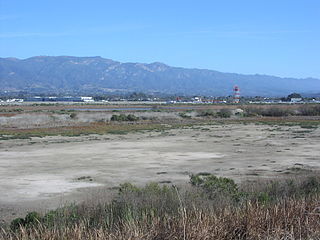
The Goleta Slough is an area of estuary, tidal creeks, tidal marsh, and wetlands near Goleta, California, United States. It primarily consists of the filled and unfilled remnants of the historic inner Goleta Bay about 8 miles (13 km) west of Santa Barbara. The slough empties into the Pacific Ocean through an intermittently closed mouth at Goleta Beach County Park just east of the UCSB campus and Isla Vista. The slough drains the Goleta Valley and watershed, and receives the water of all of the major creeks in the Goleta area including the southern face of the Santa Ynez Mountains.

<span class="mw-page-title-main">Ballona Wetlands</span> Estuary and marsh in California, United States

Ballona Wetlands Ecological Reserve is a protected area that once served as the natural estuary for neighboring Ballona Creek. The 577-acre (2.34 km2) site is located in Los Angeles County, California, just south of Marina del Rey. Ballona—the second-largest open space within the city limits of Los Angeles, behind Griffith Park—is owned by the state of California and managed by the California Department of Fish and Wildlife. The preserve is bisected generally east-west by the Ballona Creek channel and bordered by the 90 Marina freeway to the east.

<span class="mw-page-title-main">Bolsa Chica Ecological Reserve</span> Natural public land in Orange County, California, US

Bolsa Chica State Ecological Reserve is a natural reserve and public land in Orange County, governed by the state of California, and immediately adjacent to the city of Huntington Beach, California. The reserve is designated by the California Department of Fish and Wildlife (CDFW) to protect a coastal wetland and upland, with both migratory and resident threatened and endangered species of wildlife and wildflowers.

<span class="mw-page-title-main">Seal Beach National Wildlife Refuge</span> Wildlife refuge in California

The Seal Beach National Wildlife Refuge is a wildlife refuge encompassing 965 acres (3.91 km2) located in the California coastal community of Seal Beach. Although it is located in Orange County it is included as part of the San Diego National Wildlife Refuge Complex. It was established in 1972.

<span class="mw-page-title-main">Elkhorn Slough</span> Body of water in Monterey County, California

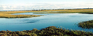
Elkhorn Slough is a 7-mile-long (11 km) tidal slough and estuary on Monterey Bay in Monterey County, California. It is California's second largest estuary and the United States' first estuarine sanctuary. The community of Moss Landing and the Moss Landing Power Plant are located at the mouth of the slough on the bay.

<span class="mw-page-title-main">Glacial Ridge National Wildlife Refuge</span> National wildlife refuge in Minnesota, United States

Glacial Ridge National Wildlife Refuge was created on October 12, 2004, the 545th National Wildlife Refuge in the United States. Its creation was the result of cooperation between at least 30 agencies or governmental entities. The creation of the refuge was spearheaded by The Nature Conservancy, and the initial endowment of 2,300 acres (9.3 km2) of land was donated by the Conservancy. In light of its planned final size of 37,756 acres (153 km2), it is described by the US Fish and Wildlife Service as "the largest tallgrass prairie and wetland restoration project in U.S. history."

<span class="mw-page-title-main">Yolo Bypass Wildlife Area</span> Protected area in California

The Yolo Bypass Wildlife Area, located within the Yolo Bypass in Yolo County, California, is managed by the California Department of Fish and Wildlife with the intent of restoring and managing a variety of wildlife habitats in the Yolo Basin, a natural basin in the north part of the Sacramento-San Joaquin River Delta. The creation of the wildlife area was spearheaded by the Yolo Basin Foundation. The California Department of Fish and Wildlife and Yolo Basin Foundation are the core partners in the operation of this resource located at 38.550515°N 121.626291°W

<i>Cuscuta salina</i> Species of flowering plant

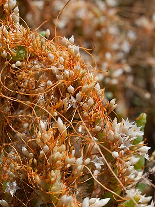
Cuscuta salina is a species of dodder known by the English name salt marsh dodder and is a native plant of western North America. The habitat includes coastal tidal wetlands in California, as well as saline habitats away from the coast, such as vernal pools and salt flats. Salt Marsh Dodder is a parasitic plant, wrapping orange-colored stems around natural wetland vegetation and absorbing nutrients of host plants via their specialized structures called haustoria.

<span class="mw-page-title-main">San Elijo Lagoon</span> Coastal wetland in San Diego County, California, United States

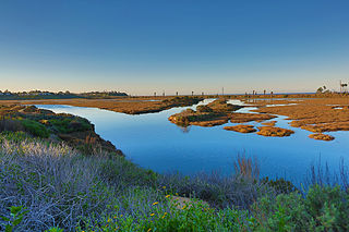
San Elijo Lagoon Ecological Reserve is one of the largest remaining coastal wetlands in San Diego County, California, United States.

Pass a Loutre Wildlife Management Area (WMA) is a 115,000-acre (47,000 ha) protected wetland in Plaquemines Parish, Louisiana, United States. The WMA is located due south and bordering the 48,000 acre Delta National Wildlife Refuge, accessible only by air or boat, contains the Pass A L'Outre Lighthouse, and Port Eads is within the boundary.

<span class="mw-page-title-main">Crissy Marsh</span>

Crissy Marsh is a wetland area in San Francisco, California, United States. Crissy Marsh has brackish waters, making an ideal habitat for many bird species along the Pacific Flyway. Here, freshwater runoff meets the salt water of the bay. It is 130-acres and located on the northern end of the San Francisco Peninsula. This salt marsh was largely destroyed to build Crissy Field, an airfield used during World War I and World War II. It has since been restored, with the airfield being removed. It now hosts abundant and recovering wildlife on the northern San Francisco coast.

<span class="mw-page-title-main">Palos Verdes Peninsula Land Conservancy</span> Non-profit organization in California

The Palos Verdes Peninsula Land Conservancy (PVPLC) is a non-profit organization that is based on the Palos Verdes Peninsula in southwestern Los Angeles County, California.

The San Diego National Wildlife Refuge Complex is a series of wildlife refuges established by the United States National Wildlife Service beginning in 1972. The complex incorporates five refuges in San Diego County and Orange County in California.

<span class="mw-page-title-main">Anaheim Bay</span> Harbor and wetland complex in California, United States

Anaheim Bay is an extensive harbor and wetland complex in Orange County, California in the United States. The bay is located on the Pacific Ocean coast of northwestern Orange County next to Seal Beach and is split into several distinct but interconnected parts. The term "Anaheim Bay" generally refers to the deep-water Navy harbor at the bay entrance. Further southeast are the Huntington Harbor, which serves small private vessels, and the Bolsa Bay, a salt-water estuary. Bordering the bay are hundreds of acres of salt marshes, some of the largest remaining such habitats in Southern California.

Joy Buswell Zedler is an American ecologist and professor of botany at the University of Wisconsin–Madison (UW), holding the title of Aldo Leopold Chair of Restoration Ecology. In addition to restoration ecology, she specializes in the ecology of wetlands, rare species, interactions between native and introduced species, and adaptive management.

<span class="mw-page-title-main">San Francisco Bay Salt Ponds</span> Salt evaporation ponds in the San Francisco Bay in California

The San Francisco Bay Salt Ponds are a roughly 16,500-acre (6,700 ha) part of the San Francisco Bay that have been used as salt evaporation ponds since the California Gold Rush era. Most of the ponds were once wetlands in the cities of Redwood City, Newark, and Hayward, and other parts of the bay.

<span class="mw-page-title-main">North Campus Open Space</span>

North Campus Open Space (NCOS) is a 136-acre wetland and upland restoration project (55 ha) in Goleta, California. Located on a former golf course, NCOS is managed by the Cheadle Center for Biodiversity and Ecological Restoration (CCBER), a research center under the Office of Research at the University of California, Santa Barbara (UCSB). The primary objectives of this project are: the restoration of the historic upper half of Devereux Slough and adjacent upland and wetland habitats that support important local native plant and animal species, reducing flood risk, providing a buffer against predicted sea level rise, and contributing to carbon sequestration while also supporting public access and outreach, and facilitating research and educational opportunities for all members of the community.

<span class="mw-page-title-main">San Gabriel and Lower Los Angeles Rivers and Mountains Conservancy</span> Government agency in California

The San Gabriel and Lower Los Angeles Rivers and Mountains Conservancy (RMC) is an agency of the State of California in the United States with the mission of preserving open space and habitat for low-impact recreation and educational uses, wildlife habitat restoration and protection, and watershed improvements within its jurisdiction. The conservancy was created by the state legislature in 1999, and is headquartered in Azusa. It is 1 of 10 conservancies within the California Natural Resources Agency. At the time of its founding, it was the state's first conservancy to primarily serve an urban area.

References

  1. Los Cerritos Wetland Area Map, Los Cerritos Wetlands Authority
  2. "Tribal Cultural Landscape" (PDF). Tribal Cultural Resources: 7. May 2020.
  3. "Los Cerritos Wetlands, Gum Grove Park and Heron Pointe Education Center", Enjoy California's Open Spaces.
  4. 1 2 Los Cerritos Wetlands Habitat Assessment Report
  5. "Los Cerritos Wetlands", Los Cerritos Wetlands Stewards website.
  6. Zembal, Richard; Hoffman, Susan M.; Patton, Robert T. (2015) "A Survey of the Belding's Savannah Sparrow" State of California Natural Resources Agency Department of Fish and Wildlife Wildlife Branch.
  7. 1 2 "Conceptual Restoration Plan", Los Cerritos Wetlands Authority
  8. "Historical Ecology and Landscape Change of the San Gabriel River and Floodplain" San Gabriel and Lower Los Angeles Rivers and Mountains Conservancy
  9. 1 2 "Wetlands & climate change - Washington State Department of Ecology". ecology.wa.gov. Retrieved May 17, 2024.
  10. "My Water Quality: Wetlands". mywaterquality.ca.gov. Retrieved May 16, 2024.
  11. "Los Cerritos Wetlands Authority" , Los Cerritos Wetlands Authority
  12. "Our Partners" , Los Cerritos Wetlands Authority
  13. "The Wetlands" , Los Cerritos Wetlands Authority.
  14. "Public Events" , Los Cerritos Wetlands Authority
  15. 1 2 Tran, Maison (October 3, 2023). "$31.8 million grant will help restore 54 acres of Los Cerritos Wetlands". Long Beach Post News. Retrieved May 16, 2024.
  16. 1 2 "Southern Los Cerritos Wetlands Restoration Project"
  17. "The Los Cerritos Wetlands Program Environmental Impact Report" . Retrieved January 19, 2021.
  18. Tran, Maison (October 3, 2023). "$31.8 million grant will help restore 54 acres of Los Cerritos Wetlands". Long Beach Post News. Retrieved October 5, 2023.

33°45′43″N118°6′30″W / 33.76194°N 118.10833°W / 33.76194; -118.10833