Lowther Castle Stead

Last updated
Lowther Castle Stead
Cumbria UK location map.svg
Archaeological site icon (red).svg
Location within Cumbria
Alternative nameCastlesteads
LocationCumbria
Coordinates 54°36′36″N2°44′47″W / 54.6099°N 2.7464°W / 54.6099; -2.7464
OS grid reference NY51892412
Type Ringwork castle
Site notes
Excavation dates2023–24

Lowther Castle Stead is a medieval site in Cumbria, possibly a ringwork castle. [1] It lies just east of the River Lowther. The castle was probably established in the 11th or 12th century as part of the Norman conquest of the region, and it was out of use by the mid-14th century. A medieval village and church were also established nearby.

Contents

The medieval castle was first investigated archaeologically in 1997 when the Lancaster University Archaeology Unit carried out an earthwork survey. In 2023, Lancaster University, the University of Central Lancashire, and Allen Archaeology carried out excavations on the site.

Location

The parish church was established in the 12th century. Lowther Park - geograph.org.uk - 58096.jpg
The parish church was established in the 12th century.

The medieval fortification of Lower Castle sits in what is now an area of woodland; west of the castle the land slopes down to the River Lowther, which flows south to north. In the Middle Ages, before the woodland was established, the castle's visibility would have made it a significant landmark in the area. [2]

The castle is 330 metres (360 yd) south of the Church of St Michael which, which dates to at least the late 12th century. [3] The medieval village of Lowther lay between the church and the ringwork castle. [4] In the medieval period, there was also a deer park for hunting, a popular pastime of medieval lords. [5]

History

It is uncertain when the medieval castle was established, but it likely dates to the 11th or 12th century. If it was established in the 11th century, it may have formed part of the Norman conquest of the region. [1] A 'castellum de Lauudre' was documented in 1174, which may refer to Lowther Castle Stead. [6]

Lowther village was arranged along two roads, one running east west and the other north south, and with the castle at the south end and the church at the north. It is likely to be a planned settlement with regularly spaced house plots. The Norman Conquest of the region led to the establishment of many planned settlements such as Melkinthorpe. [7]

The present building called Lowther Castle was built in the early 19th century by Robert Smirke. Lowther Castle.jpg
The present building called Lowther Castle was built in the early 19th century by Robert Smirke.

The medieval castle was probably abandoned in the mid-14th century, though the village continued to be inhabited. [8] Around this time, a pele tower was established about 400 metres (1,300 ft) south-east of the ringwork castle. This developed into a country house, and from the 19th century took on the name of Lowther Castle; it was abandoned after World war II. John Lowther, 1st Viscount Lonsdale, when still Sir John Lowther Bt., demolished the medieval village in 1682. [4]

Investigation

In 1997, Lancaster University Archaeology Unit carried out a survey of the earthworks of the castle and associated medieval village to the east and north. [9]

In 2023, Sophie Thérèse Ambler secured funding from the Castle Studies Trust to carry out the first geophysical surveys and excavation at the site of the castle and medieval village. Involving Lancaster University, the University of Central Lancashire, and Allen Archaeology the aim was to investigate the early history of the site. [1] [10] [11] The geophysical survey focused on the medieval village. [12] The project featured on Digging for Britain , a television series about archaeology in the UK. [13]

Layout

Lowther Castle consists of a roughly square enclosure bounded by a bank. The interior of the castle was artificially raised above ground level. It is likely that the bank was originally higher, and the top levels have eroded over time. It is also probable that the bank would have bee topped by a timber palisade. The castle was entered through a gap in the eastern bank. [2]

Related Research Articles

<span class="mw-page-title-main">Maryport</span> Town in Cumbria, England

Maryport is a town and civil parish in Cumbria, England.

<span class="mw-page-title-main">Urswick</span> Human settlement in England

Urswick is a civil parish that includes the villages of Great Urswick and Little Urswick. It is located in the Furness area of Cumbria, England. The villages are situated to the south-west of the town of Ulverston. In the 2001 census the parish had a population of 351, decreasing at the 2011 census to 1,397.

<span class="mw-page-title-main">Penhallam</span> Former fortified manor house in Cornwall

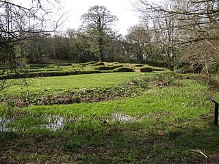
Penhallam is the site of a fortified manor house near Jacobstow in Cornwall, England. There was probably an earlier, 11th-century ringwork castle on the site, constructed by Tryold or his son, Richard fitz Turold in the years after the Norman invasion of 1066. Their descendants, in particular Andrew de Cardinham, created a substantial, sophisticated manor house at Penhallam between the 1180s and 1234, building a quadrangle of ranges facing onto an internal courtyard, surrounded by a moat and external buildings. The Cardinhams may have used the manor house for hunting expeditions in their nearby deer park. By the 14th century, the Cardinham male line had died out and the house was occupied by tenants. The surrounding manor was broken up and the house itself fell into decay and robbed for its stone. Archaeological investigations between 1968 and 1973 uncovered its foundations, unaltered since the medieval period, and the site is now managed by English Heritage and open to visitors.

Buckton Castle was a medieval enclosure castle near Carrbrook in Stalybridge, Greater Manchester, England. It was surrounded by a 2.8-metre-wide (9 ft) stone curtain wall and a ditch 10 metres (33 ft) wide by 6 metres (20 ft) deep. Buckton is one of the earliest stone castles in North West England and only survives as buried remains overgrown with heather and peat. It was most likely built and demolished in the 12th century. The earliest surviving record of the site dates from 1360, by which time it was lying derelict. The few finds retrieved during archaeological investigations indicate that Buckton Castle may not have been completed.

<span class="mw-page-title-main">Loughor Castle</span> Medieval fortification in southwestern Wales

Loughor Castle is a ruined, medieval fortification located in the town of Loughor, Wales. The castle was built around 1106 by the Anglo-Norman lord Henry de Beaumont, during the Norman invasion of Wales. The site overlooked the River Loughor and controlled a strategic road and ford running across the Gower Peninsula. The castle was designed as an oval ringwork, probably topped by wicker fence defences, and reused the remains of the former Roman fort of Leucarum.

<span class="mw-page-title-main">Clavering Castle</span>

Clavering Castle remains are situated in the small parish village of Clavering in the county of Essex, England, 50m north of the church of St Mary and St Clement on the southern bank of the River Stort, some 10 kilometres (6.2 mi) north of Bishop's Stortford.

<span class="mw-page-title-main">Gleaston Castle</span> 14th-century enclosure castle near Gleaston, England

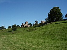
Gleaston Castle is a medieval building in a valley about 1 kilometre (0.62 mi) north-east of the village of Gleaston. The village lies between the towns of Ulverston and Barrow-in-Furness in the Furness peninsula, Cumbria, England. Gleaston Castle has a quadrilateral plan, with a tower at each corner. The largest of these, the north-west tower, probably housed a hall.

<span class="mw-page-title-main">Alauna (Maryport)</span> Roman fort and settlement on the site of present-day Maryport in Cumbria, England

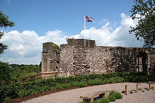
Alauna was a castrum or fort in the Roman province of Britannia. It occupied a coastal site just north of the town of Maryport in the English county of Cumbria.

<span class="mw-page-title-main">Thetford Castle</span> 11th-century castle in Thetford, England

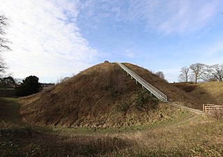
Thetford Castle is a medieval motte and bailey castle in the market town of Thetford in the Breckland area of Norfolk, England. The first castle in Thetford, a probable 11th-century Norman ringwork called Red Castle, was replaced in the 12th century by a much larger motte and bailey castle on the other side of the town. This new castle was largely destroyed in 1173 by Henry II, although the huge motte, the second largest man-made mound in England, remained intact. The motte, recognised as a scheduled monument, now forms part of a local park, and the remains are known variously as Castle Hill, Castle Mound and Military Parade.

Watch Hill Castle is a medieval motte-and-bailey on the boundary of Bowdon and Dunham Massey, Greater Manchester, England. It is a scheduled monument. The castle is located north of the River Bollin and south of a deep ravine.

<span class="mw-page-title-main">Monmouth Castle</span>

Monmouth Castle is a castle close to the centre of the town of Monmouth, the county town of Monmouthshire, on a hill above the River Monnow in south-east Wales.

<span class="mw-page-title-main">Pilsbury Castle</span>

Pilsbury Castle was a Norman castle in Derbyshire near the present-day village of Pilsbury, overlooking the River Dove.

Stockport Castle was a promontory castle in Stockport, Greater Manchester, England. The castle was in the medieval town, overlooking a ford over the River Mersey. It was first documented in 1173, but the next mention of it is in 1535 when it was in ruins. What remained of the castle was demolished in 1775.

<span class="mw-page-title-main">Ringwork</span> Form of fortified defensive structure

A ringwork is a form of fortified defensive structure, usually circular or oval in shape. Ringworks are essentially motte-and-bailey castles without the motte. Defences were usually earthworks in the form of a ditch and bank surrounding the site.

<span class="mw-page-title-main">Manchester Castle</span> Building in Greater Manchester, England

Manchester Castle was a medieval fortified manor house, probably located on a bluff where the rivers Irk and Irwell meet, near to Manchester Cathedral, where Chetham's School of Music now is, putting it near the edge of the medieval township of Manchester.

Ranulf le Meschin, 3rd Earl of Chester (1070–1129) was a Norman magnate based in northern and central England. Originating in Bessin in Normandy, Ranulf made his career in England thanks to his kinship with Hugh d'Avranches - the Earl of Chester, the patronage of kings William II Rufus and Henry I Beauclerc, and his marriage to Lucy, heiress of the Bolingbroke-Spalding estates in Lincolnshire.

<span class="mw-page-title-main">Brocavum</span>

Brocavum is the Latin name of a Roman fort at Brougham near Penrith, Cumbria. The fort survives as earthworks, but no excavation of these has been carried out so far.

Sophie Ambler is a medieval historian, focussing on politics, ethics, and warfare, often through the lens of the Crusades. She undertook her PhD at King's College London, supervised by David A. Carpenter.

References

  1. 1 2 3 "Lowther Castle: Archaeologists bid for signs of Norman conquest". BBC News. 2023-02-27. Retrieved 2024-02-21.
  2. 1 2 Ambler, Sophie (2023-07-28). "Dig Diary Six: Lowther Castle and Village Project Highlights". Castle Studies Trust. Retrieved 2024-02-24.
  3. "Lowther", An Inventory of the Historical Monuments in Westmorland, His Majesty's Stationery Office, pp. 158–162, 1936
  4. 1 2 Scott, Ian; Newman, Caron; Quartermaine, Jamie (1997). Lowther Park, Cumbria. Archaeological Survey Report (Report). Lancaster University Archaeology Unit. p. 10.
  5. Scott, Ian; Newman, Caron; Quartermaine, Jamie (1997). Lowther Park, Cumbria. Archaeological Survey Report (Report). Lancaster University Archaeology Unit. pp. 10–11, 16.
  6. Bradley, Jeremy; Clark, Paul (2007). Lowther Castle, Cumbria (Report). Oxford Archaeology North. p. 6. doi: 10.5284/1026527 .
  7. Bradley, Jeremy; Clark, Paul (2007). Lowther Castle, Cumbria (Report). Oxford Archaeology North. p. 19. doi: 10.5284/1026527 .
  8. Scott, Ian; Newman, Caron; Quartermaine, Jamie (1997). Lowther Park, Cumbria. Archaeological Survey Report (Report). Lancaster University Archaeology Unit. p. 13.
  9. Scott, Ian; Newman, Caron; Quartermaine, Jamie (1997). Lowther Park, Cumbria. Archaeological Survey Report (Report). Lancaster University Archaeology Unit.
  10. Manuschka, Jacob (2023-12-22). "Unearthing the overlooked history of the Norman Conquest in Cumbria". News and Star. Retrieved 2024-02-21.
  11. "Investigation of Lowther's medieval castle and village to start". University of Central Lancashire. Retrieved 2024-03-19.
  12. Evershed, Robert (2023). Geophysical Survey by Magnetometry on land at Lowther Castle and Gardens, Penrith, Cumbria (Report). Allen Archaeology. doi: 10.5284/1113818 .
  13. Cooper, Isaac (2023-12-13). "Projects unearthing Cumbria's past to feature on BBC's 'Digging for Britain'". News and Star. Retrieved 2024-03-19.