
Katanga was one of the four large provinces created in the Belgian Congo in 1914. It was one of the eleven provinces of the Democratic Republic of the Congo between 1966 and 2015, when it was split into the Tanganyika, Haut-Lomami, Lualaba, and Haut-Katanga provinces. Between 1971 and 1997, its official name was Shaba Province.
Orientale Province is one of the former provinces of the Democratic Republic of the Congo and its predecessors the Congo Free State and the Belgian Congo. It went through a series of boundary changes between 1898 and 2015, when it was divided into smaller units.

Kolwezi or Kolwesi is the capital city of Lualaba Province in the south of the Democratic Republic of the Congo, west of Likasi. It has an airport and a railway to Lubumbashi. Just outside of Kolwezi there is the static inverter plant of the HVDC Inga-Shaba. The population is approximately 573,000.
Tanganyika is one of the 21 new provinces of the Democratic Republic of the Congo created in the 2015 repartitioning. Tanganyika, Haut-Katanga, Haut-Lomami and Lualaba provinces are the result of the splitting up of the former Katanga province. Tanganyika was formed from the Tanganyika district whose town of Kalemie was elevated to capital city of the new province.

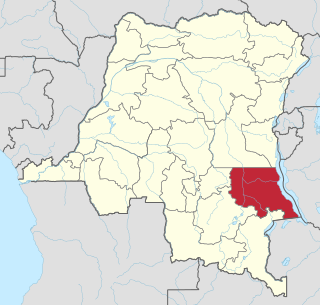
Haut-Katanga is one of the 21 new provinces of the Democratic Republic of the Congo created in the 2015 repartitioning. Haut-Katanga, Haut-Lomami, Lualaba, and Tanganyika provinces are the result of the dismemberment of the former Katanga province. Haut-Katanga was formed from the Haut-Katanga district and the independently administered cities of Likasi and Lubumbashi. Lubumbashi retained its status as a provincial capital. The estimated population was 5,718,800 in 2020.

Lualaba District was a district of the pre-2015 Katanga Province in the Democratic Republic of the Congo. The district dates back to the days of the Congo Free State and the Belgian Congo. The original Lualaba District was merged into Katanga in 1910, but in 1933 a new Lualaba District was formed within Katanga. After various significant boundary changes, in 2015 the district became the western part of the present Lualaba Province.

Haut-Katanga District is a former district located in the former Katanga Province of the Democratic Republic of the Congo. The copper mining centers of Lubumbashi and Likasi were surrounded by the district but were administratively separate.

Haut-Lomami is one of the 21 new provinces of the Democratic Republic of the Congo created in the 2015 repartitioning. Haut-Lomami, Haut-Katanga, Lualaba, and Tanganyika provinces are the result of the dismemberment of the former Katanga province. Haut-Lomami was formed from the Haut-Lomami district whose town of Kamina was elevated to capital city of the new province.

Tshopo is one of the 21 new provinces of the Democratic Republic of the Congo created in the 2015 repartitioning. It is situated in the north central part of the country on the Tshopo River, for which it is named.
Kasai District was a district of the Congo Free State, Belgian Congo and the Democratic Republic of the Congo, named after the Kasai River. It was formed around 1885 and went through several large changes in extent in the years that followed. The 1933 version of the district roughly corresponded to the former Kasai-Occidental province and the present Kasaï and Kasaï-Central provinces.

Haut-Lomami District was a district of the pre-2015 Katanga Province in the Democratic Republic of the Congo. The district dates back to the days of the Belgian Congo. At its greatest extent it roughly corresponded to the northern part of the current Lualaba Province and to the present Haut-Lomami Province.

The Districts of the Belgian Congo were the primary administrative divisions when Belgium annexed the Congo Free State in 1908, each administered by a district commissioner. In 1914 they were distributed among four large provinces, with some boundary changes. In 1933 the provinces were restructured into six, again with boundary changes. The number of districts fluctuated between 12 and 26 through splits and consolidations, first rising, then falling, then rising again.
Lomami District was a district of the Belgian Congo from 1912 to 1933, when it was dissolved. It covered very roughly the same area as the present Lomami Province and the northwest of Haut-Lomami Province.
Haut-Luapula District was a district of the Belgian Congo from 1912 to 1933, when it was dissolved. It roughly corresponded to the southern part of the present Haut-Katanga Province.
Tanganika-Moero District was a district of the Belgian Congo from 1912 to 1933, when it was dissolved. It roughly corresponded to the present Tanganyika Province and the northern part of Haut-Katanga Province.

Tanganika District was a district of the pre-2015 Katanga Province in the Democratic Republic of the Congo. The district dates back to the days of the Belgian Congo. At its greatest extent it roughly corresponded to the present Tanganyika Province, with a small portion in the southwest now in Haut-Lomami Province.
Luapula-Moero District was a district of the pre-2015 Katanga Province in the Belgian Congo and Democratic Republic of the Congo. It roughly corresponded in area to the present Haut-Katanga Province.
Nseke Hydroelectric Power Station is an operational hydropower plant in the Democratic Republic of the Congo, with installed capacity of 260 megawatts (350,000 hp). It is operated by the Congolese electricity utility company, Société Nationale d'Électricité (SNEL).

Dominique Diur (1929—1980) was a Congolese and Katangese politician who was one of the founders of the CONAKAT party.

