Lulworth Cove is a cove near the village of West Lulworth, on the Jurassic Coast in Dorset, southern England. The cove is one of the world's finest examples of such a landform, and is a World Heritage Site and tourist location with approximately 500,000 visitors every year, of whom about 30 per cent visit in July and August. It is close to the rock arch of Durdle Door and other Jurassic Coast sites.
Lulworth is the popular name for an area on the coast of Dorset, South West England notable for its castle and cove. However, there is no actual place or feature called simply "Lulworth", the villages are East and West Lulworth and the coastal feature is Lulworth Cove.

The Isle of Purbeck is a peninsula in Dorset, England. It is bordered by water on three sides: the English Channel to the south and east, where steep cliffs fall to the sea; and by the marshy lands of the River Frome and Poole Harbour to the north. Its western boundary is less well defined, with some medieval sources placing it at Flower's Barrow above Worbarrow Bay. John Hutchins, author of The History and Antiquities of the County of Dorset, defined Purbeck's western boundary as the Luckford Lake steam, which runs south from the Frome. According to writer and broadcaster Ralph Wightman, Purbeck "is only an island if you accept the barren heaths between Arish Mell and Wareham as cutting off this corner of Dorset as effectively as the sea." The most southerly point is St Alban's Head.

Durdle Door is a natural limestone arch on the Jurassic Coast near Lulworth in Dorset, England. It is privately owned by the Weld Family who own the Lulworth Estate, but it is also open to the public.

West Lulworth is a village and civil parish in the English county of Dorset, situated on the English Channel beside Lulworth Cove. In the 2011 census the civil parish—which includes most of Lulworth Camp army base—had 291 households and a population of 714. The village is a gateway to the Jurassic Coast World Heritage Site and is a popular tourist destination, especially for day trips.

East Lulworth is a village and civil parish nine miles east of Dorchester, near Lulworth Cove, in the county of Dorset, South West England. It consists of 17th-century thatched cottages. The village is now dominated by the barracks of the Royal Armoured Corps Gunnery School who use a portion of the Purbeck Hills as a gunnery range. In 2013 the estimated population of the civil parish was 160.

The Lulworth skipper is a butterfly of the family Hesperiidae. Its name is derived from Lulworth Cove in the county of Dorset, England, where the first specimens in Great Britain were collected in 1832 by English naturalist James Charles Dale.

Stair Hole is a small cove located just west of Lulworth Cove in Dorset, southern England. The folded limestone strata known as the Lulworth crumple are particularly visible at Stair Hole. There are several caves visible from the seaward side of Stair Hole; Cathedral Cavern is supported by pillars of rock rising out of the water. The rock structure was created during the Alpine orogeny and exposed by subsequent erosion.

Wool railway station serves the village of Wool in Dorset, England. It is on the South West Main Line, 125 miles 69 chains (202.6 km) down the line from London Waterloo. South Western Railway manages the station and operates all services.

Bindon Hill is an extensive Iron Age earthwork enclosing a coastal hill area on the Jurassic Coast near Lulworth Cove in Dorset, England, about 19 kilometres (12 mi) west of Swanage, about 6 kilometres (3.7 mi) south west of Wareham, and about 17 kilometres (11 mi) south east of Dorchester. It is within an Area of Outstanding Natural Beauty.
The Weld family may refer to an ancient English family, and to their possible relations in New England, an extended family of Boston Brahmin. An early record of a Weld holding public office, is of the High Sheriff of London in 1352, William. In the 16th and 17th centuries people called Weld and living in Cheshire began to travel and to settle in the environs of London, in Shropshire, in Suffolk and thence in the American Colonies, and in Dorset. While the Welds of England had adopted Protestantism, the exception were all three sons of Sir John Weld of Edmonton who married into elite recusant families thus reverting, with their descendants, to Roman Catholicism. The noted Catholic Weld lineage, unbroken till the new Millenium, is that of Lulworth Castle in Dorset.

Bovington Camp is a British Army military base in Dorset, England. Together with Lulworth Camp it forms part of Bovington Garrison.

Mupe Bay is a bay with a shingle beach to the east of Lulworth Cove in Dorset, England, and is part of the Jurassic Coast World Heritage Site.

Swyre Head, Lulworth is a hill and sea cliff which lies on the Jurassic Coast between Bat's Head to the west and Durdle Door to the east, close to Lulworth in Dorset, England. It is located approximately 8 miles (12.9 km) east of Weymouth and 14 miles (22.5 km) west of Swanage.

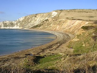
St Oswald's Bay is located near Lulworth on the Jurassic Coast in Dorset, England.
Flower’s Barrow is an Iron Age hillfort, built over 2500 years ago, above Worbarrow Bay in Dorset on the south coast of England.

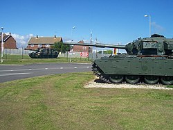
The Lulworth Ranges are military firing ranges located between Wareham and Lulworth in Dorset, England. They cover an area of more than 2,830 hectares, are leased in a rolling contract from the Weld Estate by the Ministry of Defence and are part of the Armoured Fighting Vehicles Gunnery School based at Lulworth Camp. The ranges were established in 1917.

Brandy Bay is a small secluded southwest-facing bay, with an oil shale and shingle beach immediately below Gad Cliff and Tyneham Cap, to the east of Worbarrow Bay and to the west of Hobarrow Bay on the south coast of the Isle of Purbeck, in Dorset, England.

Hobarrow Bay is a small secluded southwest-facing bay, with an oil shale and shingle beach to the southeast of Brandy Bay and to the southwest of Kimmeridge on the south coast of the Isle of Purbeck, in Dorset, England.

Arish Mell is a small embayment and beach between Mupe and Worbarrow Bays in Dorset, England and is part of the Jurassic Coast and the South West Coast Path passes just to the north. It is about 1 mile (1.6 km) due south of Lulworth Castle and East Lulworth. The bay is relatively inaccessible because it is within the Lulworth Ranges, an Army tank firing range, and although the Range Walks are open at most weekends and public holidays, there is no public access to the beach and cliffs.