
The Territory of Ashmore and Cartier Islands is an uninhabited external territory of Australia consisting of four low-lying tropical islands in two separate reefs, and the 12-nautical-mile territorial sea generated by the islands. The territory is located in the Indian Ocean situated on the edge of the continental shelf, about 320 km (199 mi) off the northwest coast of Australia and 144 km (89 mi) south of the Indonesian island of Rote.

The terms international waters or trans-boundary waters apply where any of the following types of bodies of water transcend international boundaries: oceans, large marine ecosystems, enclosed or semi-enclosed regional seas and estuaries, rivers, lakes, groundwater systems (aquifers), and wetlands.

An exclusive economic zone (EEZ), as prescribed by the 1982 United Nations Convention on the Law of the Sea, is an area of the sea in which a sovereign state has special rights regarding the exploration and use of marine resources, including energy production from water and wind. It stretches from the outer limit of the territorial sea out to 200 nautical miles (nmi) from the coast of the state in question. It is also referred to as a maritime continental margin and, in colloquial usage, may include the continental shelf. The term does not include either the territorial sea or the continental shelf beyond the 200 nautical mile limit. The difference between the territorial sea and the exclusive economic zone is that the first confers full sovereignty over the waters, whereas the second is merely a "sovereign right" which refers to the coastal state's rights below the surface of the sea. The surface waters, as can be seen in the map, are international waters.
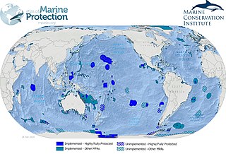
Marine protected areas (MPA) are protected areas of seas, oceans, estuaries or in the US, the Great Lakes. These marine areas can come in many forms ranging from wildlife refuges to research facilities. MPAs restrict human activity for a conservation purpose, typically to protect natural or cultural resources. Such marine resources are protected by local, state, territorial, native, regional, national, or international authorities and differ substantially among and between nations. This variation includes different limitations on development, fishing practices, fishing seasons and catch limits, moorings and bans on removing or disrupting marine life. In some situations, MPAs also provide revenue for countries, potentially equal to the income that they would have if they were to grant companies permissions to fish. The value of MPA to mobile species is unknown.
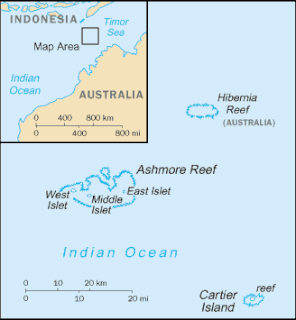
Cartier Island is an uninhabited and unvegetated sand cay in a platform reef in the Timor Sea north of Australia and south of Indonesia. It is within the Territory of Ashmore and Cartier Islands, an external territory of Australia. The land area of Cartier Island is about 0.4 hectares. It is located at 12°31′S123°33′E, on the edge of the Sahul Shelf, about 300 kilometres (190 mi) off the north west coast of Western Australia, 200 kilometres (120 mi) south of the Indonesian island of Roti, and 70 kilometres (43 mi) south-east of Ashmore Reef.

Until the 1960s, agriculture and fishing were the dominant industries of the economy of South Korea. The fishing industry of South Korea depends on the existing bodies of water that are shared between South Korea, China and Japan. Its coastline lies adjacent to the Yellow Sea, the East China Sea and the Sea of Japan, and enables access to marine life such as fish and crustaceans.

The Australia–Indonesia border is a maritime boundary running west from the two countries' tripoint maritime boundary with Papua New Guinea in the western entrance to the Torres Straits, through the Arafura Sea and Timor Sea, and terminating in the Indian Ocean. The boundary is, however, broken by the Timor Gap, where Australian and East Timorese territorial waters meet and where the two countries have overlapping claims to the seabed.

As with other countries, New Zealand’s 200 nautical miles exclusive economic zone gives its fishing industry special fishing rights. It covers 4.1 million square kilometres. This is the sixth largest zone in the world, and is fourteen times the land area of New Zealand.

As with other countries, the 200 nautical miles (370 km) exclusive economic zone (EEZ) off the coast of the United States gives its fishing industry special fishing rights. It covers 11.4 million square kilometres, which is the second largest zone in the world, exceeding the land area of the United States.
The Australian Fisheries Management Authority (AFMA) is the Australian Government agency responsible for the management and sustainable use of fisheries resources including combating illegal fishing activities in the Australian Fishing Zone that covers 8,148,250 square kilometres, the third largest in the world, and in most of Australia's Exclusive Economic Zone, which extends to 200 nautical miles (370 km) from the coastline of Australia and its external territories, except where a maritime delimitation agreement exists with a state.) AFMA is an agency of the Australian Department of Agriculture and Water Resources. The Authority does not have a legal identity separate from the Commonwealth.

The Memorandum of Understanding on the Conservation of Migratory Sharks is an international instrument for the conservation of migratory species of sharks. It was founded under the auspices of the Convention on the Conservation of Migratory Species of Wild Animals.
An archipelagic state is an island country that consists of an archipelago. The designation is legally defined by the United Nations Convention on the Law of the Sea (UNCLOS). In various conferences, The Bahamas, Fiji, Indonesia, Papua New Guinea, and the Philippines are the five original sovereign states that obtained approval in the UNCLOS signed in Montego Bay, Jamaica on 10 December 1982 and qualified as the archipelagic states.
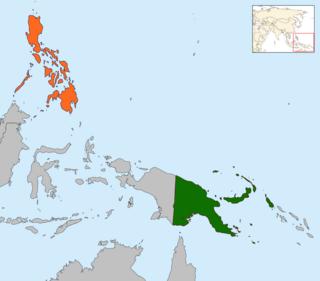
Papua New Guinea–Philippines relations refers to the bilateral relations of Papua New Guinea and the Philippines. Papua New Guinea has an embassy in Manila and the Philippines has an embassy in Port Moresby, which is also accredited to the Solomon Islands, Vanuatu and Fiji.

Browse Island is a small, approximately 14-hectare (35-acre), uninhabited island lying in the Timor Sea about 180 kilometres (110 mi) north-west of the Kimberley coast of north-western Australia. It is a Western Australian Nature Reserve that is classed as 'Not Class A' vested with the state Conservation Commission and managed by the Department of Environment and Conservation. It is considered Western Australia's most remote island, and is also one of the most remote Australian islands to not fall under external territory status.
Australian marine parks are marine protected areas located within Australian waters and are managed by the Australian government. These waters generally extend from three nautical miles off the coast to the outer limit of Australia’s Exclusive Economic Zone at 200 nautical miles while marine protected areas located closer in-shore are the responsibility of the states or the Northern Territory.

The Directorate General of Marine and Fisheries Resources Surveillance is a government agency under the management of the Ministry of Marine Affairs and Fisheries of Indonesia. Formally established on 23 November 2000 according to Presidential Decree No. 165/2000, the PSDKP is the agency responsible for supervising the marine and fishery resources of the Republic of Indonesia. The main mission of PSDKP is the prevention of Illegal, unreported and unregulated fishing in Indonesian waters, which has caused a substantial loss for Indonesia's fishing industry. In its mission to prevent illegal fishing, PSDKP has conducted joint-operations with the Indonesian Navy, Water Police, Sea and Coast Guard, the Maritime Security Agency and Customs. PSDKP is however is not associated with these agencies.

Australia's exclusive economic zone (EEZ) was declared on 1 August 1994 and extends from 12 to 200 nautical miles from the coastline of Australia and its external territories, except where a maritime delimitation agreement exists with another state. To the 12 nautical-mile boundary is Australia's territorial waters. Australia has the third-largest exclusive economic zone, behind the United States and France but ahead of Russia, with the total area of 8,148,250 square kilometres (3,146,060 sq mi), which exceeds its land territory.
The Cartier Island Marine Park is an Australian marine park that covers the Cartier Island and reef surrounds, about 610 km (380 mi) north of Broome, Western Australia. The marine park covers an area of 172 km2 (66 sq mi) and is assigned IUCN category Ia. It is one of the 13 parks managed under the North-west Marine Parks Network.
The Ashmore Reef Marine Park is an Australian marine park that covers the Ashmore Reef, which is located about 630 km (390 mi) north of Broome and 110 km (68 mi) south of the Indonesian island of Rote. The marine park covers an area of 583 km2 (225 sq mi) and is assigned IUCN category Ia. It is one of 13 parks managed under the North-west Marine Parks Network.

The exclusive economic zone of Canada is the area of the sea in which Canada has special rights regarding the exploration and use of marine resources, as prescribed by the 1982 United Nations Convention on the Law of the Sea.
