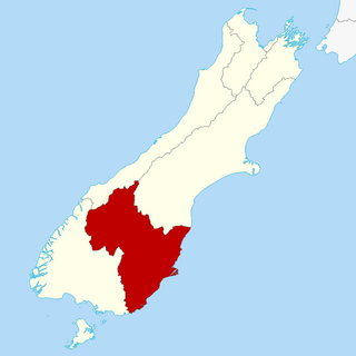
Otago is a region of New Zealand located in the southern half of the South Island administered by the Otago Regional Council. It has an area of approximately 32,000 square kilometres (12,000 sq mi), making it the country's second largest local government region. Its population was 254,600 in June 2023.

Queenstown is a resort town in Otago in the south-west of New Zealand's South Island. It has an urban population of 29,000.

Alexandra is a town in the Central Otago district of the South Island of New Zealand. It is on the banks of the Clutha River, on State Highway 8, 188 kilometres (117 mi) by road from Dunedin and 33 kilometres (21 mi) south of Cromwell. The nearest towns to Alexandra via state highway 8 are Clyde seven kilometres to the northwest and Roxburgh forty kilometres to the south. State highway 85 also connects Alexandra to Omakau, Lauder, Oturehua, Ranfurly and on to Palmerston on the East Otago coast.

Arrowtown is a historic gold mining town in the Otago region of the South Island of New Zealand. Arrowtown is located on the banks of the Arrow River approximately 7.5 km from State Highway 6. Arrowtown is located 19.5 kilometres to the east of Queenstown. As well as the route via State Highway 6 at Arrow Junction, there is also road access directly to Queenstown via Arthurs Point and a third route via the picturesque Lake Hayes.

The Kawarau River is a river in the South Island of New Zealand. It drains Lake Wakatipu in northwestern Otago via the lake's Frankton Arm. The river flows generally eastwards for about 60 kilometres (37 mi) and passes through the steep Kawarau Gorge until it joins Lake Dunstan near Cromwell. Before the construction of the Clyde High Dam, the Kawarau joined the Clutha River / Mata-Au in a spectacular confluence at Cromwell. The Shotover River enters the Kawarau from the north; the Nevis River enters it from the south. With many rapids and strong currents, the river can be dangerous and has claimed many lives. It is popular for bungy jumping and kayaking.

The Shotover River is located in the Otago region of the South Island of New Zealand. The name correctly suggests that this 75-kilometre (47 mi) long river is fast flowing, with numerous rapids. The river flows generally south from the Southern Alps on its journey running through the Skippers Canyon, draining the area between the Richardson Mountains and the Harris Mountains, before flowing into the Kawarau River east of Queenstown.

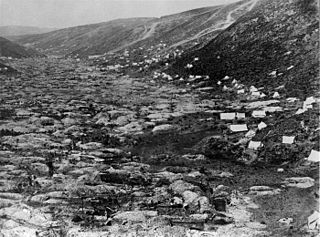
The Otago Gold Rush was a gold rush that occurred during the 1860s in Central Otago, New Zealand. This was the country's biggest gold strike, and led to a rapid influx of foreign miners to the area – many of them veterans of other hunts for the precious metal in California and Victoria, Australia. The number of miners reached its maximum of 18,000 in February 1864.
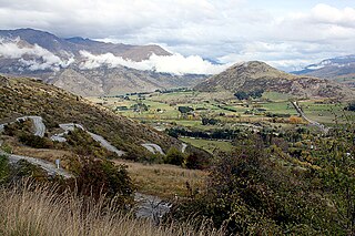
The Crown Range is a mountain range that lies to the east of the Wakatipu Basin in Otago, New Zealand. It is noted for two features, the Cardrona Alpine Resort, on the slopes of the 1900 metre Mount Cardrona, and a highway, known as the Crown Range Road, which winds steeply between Arrow Junction, just south of Arrowtown, and Wānaka to the north.
The Gold Fields District electorate was a 19th-century parliamentary electorate in the Otago region, New Zealand. It was created in 1862, with the first elections in the following year, and it returned two members. It was one of eventually three special interest constituencies created to meet the needs of gold miners. All three of these electorates were abolished in 1870. A unique feature of the Gold Fields District was that it was superimposed over other electorates, and voting was open to those who had held a mining license for some time. As such, suffrage was more relaxed than elsewhere in New Zealand, as voting was otherwise tied to property ownership. Another feature unique to the gold mining electorates was that no electoral rolls were prepared, but voting could be done upon showing a complying miner's license.
The Gold Field Towns electorate was a 19th-century parliamentary electorate in the Otago region of New Zealand. It was the second gold mining electorate in Otago, one of three special interest constituencies created to meet the needs of gold miners; the third electorate was located on the West Coast. The Gold Field Towns electorate was in 1865, with the first elections in the following year, and it returned one member. All three of these special interest electorates were abolished in 1870. A unique feature of the Gold Field Towns electorate was that it covered ten separate towns within the area of the Gold Fields, which in turn was overlaid of a number of general electorates in the Otago area. Voting was open to those who had held a mining license for some time. As such, suffrage was more relaxed than elsewhere in New Zealand, as voting was otherwise tied to property ownership. Another feature unique to the gold mining electorates was that no electoral rolls were prepared, but voting could be done upon showing a complying miner's license.
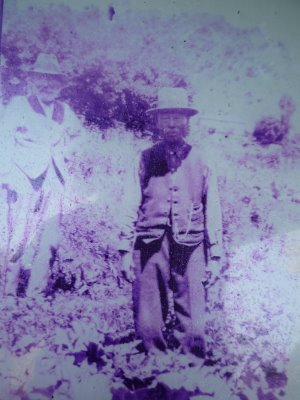
Ah Lum was a gold miner and store owner in Arrowtown, New Zealand.
Skippers Canyon is a historic and scenic gorge, some 22 kilometres in length, several kilometres north of Queenstown, New Zealand.

Choie Sew Hoy also known as Charles Sew Hoy was a New Zealand merchant, Chinese leader, gold-dredger and a New Zealand Business Hall of Fame laureate. He was born in the village of Sha Kong in the Poon Yu District of Guangdong Province, China in about 1838.
Queenstown Police Station is the largest police station in the Otago Lakes Central Area which is one of three policing areas in the Southern District of the New Zealand Police. The Otago Lakes Central Area headquarters has returned to Queenstown Police Station after a period at Alexandra Police Station. The area of responsibility covered by the Queenstown Police extends from Kingston in the south, to the Crown Range summit in the north, and from Glenorchy and its environs in the west, to the Roaring Meg power station in the Kawarau Gorge in the east.

Edith Cavell Bridge is a bridge over the Shotover River in the Otago region in the South Island of New Zealand that stands at 47.8 metres (157 ft) tall. It is registered by Heritage New Zealand as a Category I heritage structure.

The Queenstown Trail is a cycle and walking trail funded as one of the projects of the New Zealand Cycle Trail (NZCT) system in Otago, New Zealand. It links the towns of Queenstown, Arrowtown, the suburb of Jack's Point and the area of Gibbston. It is at least 110 km in length but is not linear and instead follows the terrain often near rivers and lakes to link key places in a series of tracks that also access public land. In some places it also passes through private land such as working farms and users are encouraged to stay on the trail. The trail is a joint venture between the Government, Queenstown Lakes District Council and the Queenstown Trails Trust.
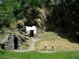
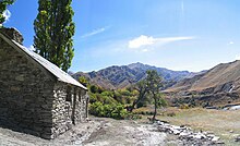
The Arrowtown Chinese Settlement is a heritage listed, historic village located in Arrowtown, New Zealand and set up by Chinese people during the Otago Gold Rush of the 1860s. The settlement is sometimes referred to as a village and has been restored and is now a common tourist attraction. It is close to Arrowtown on the banks of Bush Creek which is a tributary of the Arrow River.
The blizzard and flood of 1863 was a series of consecutive natural disasters in Central Otago in New Zealand's South Island. In the early 1860s the area was in the midst of a gold rush. From July to August 1863 the gold fields suffered from a combination of floods, snowstorms, and blizzards that caused heavy loss of life among the gold miners. At least 40 died during the July rains and more than 11 in the August snows. Sources using the earliest reports of loss of life tend to greatly overstate the numbers who died.

Oteake Conservation Park is a protected area in the Waitaki District and Otago Region of New Zealand's South Island. Oteake or place of the ake is named by Kai Tahu iwi for the ake ake, a shrub daisy found throughout the park.

The Pisa Range is a mountain range in Central Otago, in the South Island of New Zealand. It lies on the western shore of the man-made Lake Dunstan and overlooks the town of Cromwell. Its highest point, Mount Pisa, is 1,963 m.