Macomb Township, Michigan

Last updated

Macomb Township, Michigan
Township of Macomb
Macomb Township, MI location.png
Location within Macomb County
USA Michigan location map.svg
Red pog.svg
Macomb Township
Usa edcp location map.svg
Red pog.svg
Macomb Township
Coordinates: 42°39′33″N82°55′51″W / 42.65917°N 82.93083°W / 42.65917; -82.93083
CountryFlag of the United States.svg United States
State Flag of Michigan.svg  Michigan
County Flag placeholder.svg Macomb
Established1834
Government
  SupervisorFrank Viviano
   Clerk Kristi Pozzi
   Treasurer Leon Drolet
  TrusteesFrank Cusamano, Peter Lucido, Charles Oliver, Nancy Nevers
Area
[1]
  Total36.35 sq mi (94.1 km2)
  Land36.25 sq mi (93.9 km2)
  Water0.09 sq mi (0.2 km2)
Elevation
604 ft (184 m)
Population
 (2020) [2]
  Total91,663
  Density2,528.5/sq mi (976.3/km2)
Time zone UTC-5 (Eastern (EST))
  Summer (DST) UTC-4 (EDT)
ZIP Codes
48042 (Macomb)
48044 (Waldenburg)
Area code 586
FIPS code 26-50480 [3]
GNIS feature ID1626660 [4]
Website www.macomb-mi.gov

Macomb Township is a civil township of Macomb County in the U.S. state of Michigan. The population was 91,663 at the 2020 census, [2] up from 79,580 in 2010. As of 2020 it was the most-populous civil township in the state and the third most-populous township overall after the charter townships of Clinton and Canton. [5]

Contents

History

The founders of Macomb Township arrived in the early 19th century in search of flat and fertile farmland, like that near the Clinton River. Many of these early settlers were of German descent, and the German influences remain today. The Township of Macomb was officially approved by the Legislative Council on March 7, 1834. [6]

The township was named in honor of General Alexander Macomb, who was a highly decorated veteran of the War of 1812; his successful mercantile family owned most of Macomb County at one time.

Macomb Township was a large part of the lumber and logging industry of southeast Michigan in the late 19th century and early 20th century. Logs would be transported south from Wolcott Mill in Ray Township, down the Middle Branch of the Clinton River to sawmills. Romeo Plank Road is a historic route that follows the river on its western side.

Macomb Township experienced significant growth during the period of 2000–2008, boasting a 48% increase in population. [7]

Geography

Macomb Township is at the geographic center of Macomb County. Mount Clemens, the county seat, is 7 miles (11 km) to the south, and downtown Detroit is 26 miles (42 km) to the south-southwest.

According to the U.S. Census Bureau, the township has a total area of 36.35 square miles (94.15 km2), of which 36.25 square miles (93.89 km2) are land and 0.09 square miles (0.23 km2), or 0.26%, are water. [1]

Communities

Demographics

As of the census [11] of 2010, there were 79,580 people and 27,585 households in the township. The population density was 2,196.8 inhabitants per square mile (848.2/km2). There were 27,585 housing units. The racial makeup of the township was 90.5% White, 3.9% African American, 0.2% Native American, 3.1% Asian, 0.0% Pacific Islander, 0.7% from other races, and 1.6% from two or more races. Hispanic or Latino of any race were 2.3% of the population.

As of the census [3] of 2000, there were 50,478 people, 16,946 households, and 14,065 families residing in the township. The population density was 1,391.7 inhabitants per square mile (537.3/km2). There were 17,922 housing units at an average density of 494.1 per square mile (190.8/km2). The racial makeup of the township was 96.12% White, 0.84% African American, 0.19% Native American, 1.41% Asian, 0.01% Pacific Islander, 0.31% from other races, and 1.12% from two or more races. Hispanic or Latino of any race were 1.46% of the population.

There were 16,946 households, out of which 45.3% had children under the age of 18 living with them, 73.7% were married couples living together, 6.5% had a female householder with no husband present, and 17.0% were non-families. 13.7% of all households were made up of individuals, and 3.9% had someone living alone who was 65 years of age or older. The average household size was 2.97 and the average family size was 3.30.

In the township the population was spread out, with 30.2% under the age of 18, 6.9% from 18 to 24, 35.1% from 25 to 44, 20.3% from 45 to 64, and 7.4% who were 65 years of age or older. The median age was 34 years. For every 100 females, there were 99.6 males. For every 100 females age 18 and over, there were 97.3 males.

Education

The public school districts that serve residents of Macomb Township are Chippewa Valley Schools, L'Anse Creuse Public Schools, New Haven Community Schools and Utica Community Schools. [12] For public library services, the Township is served by the Clinton-Macomb Public Library district. [13]

Media

The township's flagship newspaper is the Macomb Township Chronicle. [14]

Notable people

Related Research Articles

<span class="mw-page-title-main">Macomb County, Michigan</span> County in Michigan, United States

Macomb County is a county located in the eastern portion of the U.S. state of Michigan, bordering Lake St. Clair, and is part of northern Metro Detroit. As of the 2020 Census, the population was 881,217, making it the third-most populous county in the state. The county seat is Mt. Clemens. Macomb County is part of the Detroit-Warren-Dearborn, MI Metropolitan Statistical Area. The city of Detroit is located south of the county's southern border. Macomb County contains 27 cities, townships and villages, including three of the top ten most-populous municipalities in Michigan as of the 2010 census: Warren (#3), Sterling Heights (#4) and Clinton Township (#10). Most of this population is concentrated south of Hall Road (M-59), one of the county's main thoroughfares.

<span class="mw-page-title-main">Armada Township, Michigan</span> Civil township in Michigan, United States

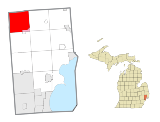
Armada Township is a civil township of Macomb County in the U.S. state of Michigan. As of the 2020 census, the township population was 5,318.

<span class="mw-page-title-main">Bruce Township, Macomb County, Michigan</span> Civil township in Michigan, United States

Bruce Township is a civil township of Macomb County in the U.S. state of Michigan. As of the 2020 census, the township population was 9,324. The largely rural township is home to the Ford Motor Company Proving Grounds, which sits on 6 square miles (16 km2) of land in the western-central part of the township.

<span class="mw-page-title-main">Chesterfield Township, Michigan</span> Charter township in Michigan, United States

Chesterfield Charter Township is a charter township of Macomb County in the U.S. state of Michigan. As of the 2020 census the population was 45,376.

<span class="mw-page-title-main">Clinton Township, Macomb County, Michigan</span> Charter township in Michigan, United States

Clinton Township is a charter township in Macomb County in the U.S. state of Michigan. A northern suburb of Metro Detroit, Clinton is about 20 miles (32 km) northeast of downtown Detroit. As of the 2020 census, the township had a population of 100,513, making it the most populous township in the state.

<span class="mw-page-title-main">Fraser, Michigan</span> City in Michigan, United States

Fraser is a city in Macomb County in the U.S. state of Michigan. A northern suburb of Detroit, Fraser is located roughly 15 miles (24.1 km) northeast of downtown Detroit. As of the 2020 census, the city had a population of 14,726.

<span class="mw-page-title-main">Harrison Township, Michigan</span> Charter township in Michigan, United States

Harrison Charter Township is a charter township of Macomb County in the U.S. state of Michigan. The population was 24,314 at the 2020 census.

<span class="mw-page-title-main">Lake Township, Macomb County, Michigan</span> Former civil township in Michigan, United States

Lake Township is a former civil township located in Macomb County in the U.S. state of Michigan. The small township consisted of 0.6 mi2 (1.7 km2) of the Macomb County portion of the village of Grosse Pointe Shores, which was part of Grosse Pointe Township and mostly located in Wayne County on the western shores of Lake Saint Clair. At the 2000 census, the township population was 80.

<span class="mw-page-title-main">Ray Township, Michigan</span> Civil township in Michigan, United States

Ray Township is a civil township of Macomb County in the U.S. state of Michigan. As of the 2020 census, the township population was 3,780.

<span class="mw-page-title-main">Roseville, Michigan</span> City in Michigan, United States

Roseville is a city in Macomb County in the U.S. state of Michigan. A northern suburb of Detroit, Roseville is located roughly 13 miles (20.9 km) northeast of downtown Detroit. As of the 2020 census, the city had a population of 47,710.

<span class="mw-page-title-main">Shelby Charter Township, Michigan</span> Charter township in Michigan, United States

Shelby Charter Township, officially the Charter Township of Shelby, is a charter township located in Macomb County in the U.S. state of Michigan. The township is an affluent northern suburb of Detroit. As of the 2020 census, the population was 79,408, up from 73,804 in 2010. Shelby Charter Township is one of the fastest-growing communities in Metro Detroit.

<span class="mw-page-title-main">Rochester Hills, Michigan</span> City in Michigan, United States

Rochester Hills is a city in Oakland County in the U.S. state of Michigan. As of the 2020 census, the city had a total population of 76,300. It is the 14th-largest city in Michigan.

<span class="mw-page-title-main">Taymouth Township, Michigan</span> Civil township in Michigan, United States

Taymouth Township is a civil township of Saginaw County in the U.S. state of Michigan. The population was 4,520 at the 2010 Census.

<span class="mw-page-title-main">Casco Township, St. Clair County, Michigan</span> Civil township in Michigan, United States

Casco Township is a civil township of St. Clair County in the U.S. state of Michigan. As of the 2020 Census, the township population was 3,990.

<span class="mw-page-title-main">Riley Township, St. Clair County, Michigan</span> Civil township in Michigan, United States

Riley Township is a civil township of St. Clair County in the U.S. state of Michigan. The population was 3,353 at the 2010 Census.

Tuscola Township is a civil township of Tuscola County in the U.S. state of Michigan. The population was 2,082 at the 2010 Census.

<span class="mw-page-title-main">Memphis, Michigan</span> City in Michigan, United States

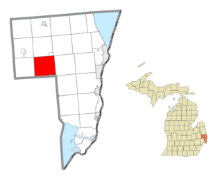
Memphis is a city that straddles the border between Macomb and St. Clair counties in the U.S. state of Michigan. The population was 1,084 at the 2020 census.

<span class="mw-page-title-main">Richmond, Michigan</span> City in Michigan, United States

Richmond is a city within Metro Detroit in the U.S. state of Michigan. The population was 5,878 at the 2020 census. Most of the city is located in Macomb County, though there is a small portion in neighboring St. Clair County.

<span class="mw-page-title-main">Richmond Township, Macomb County, Michigan</span> Civil township in Michigan, United States

Richmond Township is a civil township of Macomb County, Michigan, United States. At the 2020 census, the township population was 3,544, down from 3,665 in 2010. A portion of the city of Richmond is adjacent to the township, but is administratively autonomous.

<span class="mw-page-title-main">Washington Township, Macomb County, Michigan</span> Charter township in Michigan, United States

Washington Charter Township, located within Metro Detroit, is a charter township of Macomb County in the U.S. state of Michigan. The population was 28,165 at the 2020 census, up from 25,139 in 2010.

References

  1. 1 2 "2022 U.S. Gazetteer Files: Michigan". United States Census Bureau. Retrieved July 26, 2023.
  2. 1 2 "P1. Race – Macomb township, Macomb County, Michigan: 2020 DEC Redistricting Data (PL 94-171)". U.S. Census Bureau. Retrieved July 26, 2023.
  3. 1 2 "U.S. Census website". United States Census Bureau . Retrieved January 31, 2008.
  4. U.S. Geological Survey Geographic Names Information System: Macomb Township, Michigan
  5. "United States Census Bureau QuickFacts". Census.gov. United States Census Bureau. Retrieved August 25, 2022.
  6. "History of Macomb | Macomb, MI". www.macomb-mi.gov. Retrieved December 19, 2020.
  7. "Population and Households in Southeast Michigan, 2000-2008" (PDF). Archived from the original (PDF) on February 27, 2012. Retrieved June 30, 2012.
  8. U.S. Geological Survey Geographic Names Information System: Macomb, Michigan
  9. U.S. Geological Survey Geographic Names Information System: Meade, Michigan
  10. U.S. Geological Survey Geographic Names Information System: Waldenburg
  11. "U.S. Census Bureau QuickFacts: Macomb township, Macomb County, Michigan". Census.gov. Retrieved July 20, 2022.
  12. "Macomb County School District Map" (PDF). Michigan School District/County Series. Michigan Department of Information Technology. March 2008. Archived (PDF) from the original on February 17, 2005. Retrieved February 7, 2012.
  13. "Navigate Your Neighborhood Libraries" (PDF). Suburban Library Cooperative. p. 7. Retrieved February 7, 2012.
  14. "Macomb Township Chronicle". www.candgnews.com. Retrieved December 19, 2020.