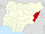
Adamawa State is a state in the North-East geopolitical zone of Nigeria, bordered by Borno to the northwest, Gombe to the west for 95 km, and Taraba to the southwest for about 366 km, while its eastern border forms part of the national border with Cameroon across the Atlantica Mountains for about 712 km. It takes its name from the historic emirate of Adamawa, with the emirate's old capital of Yola, serving as the capital city of Adamawa state. The state is one of the most heterogeneous in Nigeria, with over 100 indigenous ethnic groups. It was formed in 1991, when the former Gongola state was divided into Adamawa and Taraba states. Since it was carved out of the old Gongola State in 1991 by the General Ibrahim Badamsi Babangida military regime, Adamawa State has had 10 men, both military and civilian, controlling the levers of power, who played crucial roles in transforming the state into what it is today.

Borno State is a state in the North-East geopolitical zone of Nigeria, bordered by Yobe to the west for about 421 km, Gombe to the southwest for 93 km, and Adamawa to the south while its eastern border forms part of the national border with Cameroon for about 426 km, its northern border forms part of the national border with Niger, for about 223 km mostly across the Komadougou-Yobe River, and its northeastern border forms all of the national border with Chad for 85 km, being the only Nigerian state to border three foreign countries. It takes its name from the historic emirate of Borno, with the emirate's old capital of Maiduguri serving as the capital city of Borno State. The state was formed in 1976 when the former North-Eastern State was broken up. It originally included the area that is now Yobe State, which became a distinct state in 1991.
Damaturu is a Local Government Area and the capital city of Yobe State in northern Nigeria. It is the headquarters of the Damaturu Emirate.
Song is a town and Local Government Area in Adamawa State, Nigeria is a town and also a local government area in the state with the area council consisting districts of Song, Dumme, Dirma, Kilange, Funa, Gudu, Mboi, Kilange, Hirna, Gari, Waje, Suktu, Zumo, Waltandi and Ditera.

Boko Haram, officially known as Jamā'at Ahl as-Sunnah lid-Da'wah wa'l-Jihād, is an Islamist jihadist organization based in northeastern Nigeria, which is also active in Chad, Niger, northern Cameroon, and Mali. In 2016, the group split, resulting in the emergence of a hostile faction known as the Islamic State's West Africa Province.
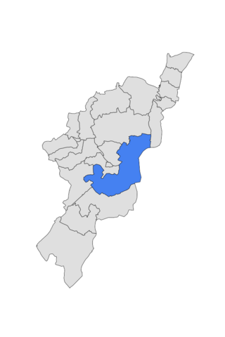
Fufore Local Government Area of Adamawa State, Nigeria.
Gombi is the Local Government Headquarter of Gombi Local Government Area of Adamawa State, Nigeria.
Maiha is a town and Local Government Area of Adamawa State, Nigeria, adjacent to the border with Cameroon.
Michika (Mwe-cika) is a town and Local Government Area in Adamawa State, Nigeria, it is the administrative headquarters of the local government. It is in Northern Adamawa State and located directly across the border from the famous tourist site of Mcedigyi in vecemwe Rhumsiki in Cameroon. Mwe-cika (Michika) is the fourth largest town in Adamawa State.
Marte is a Local Government Area of Borno State, Nigeria, on the western coast of Lake Chad. Its headquarters are in the town of Marte
Bama is a town and a local government area in the central part of Borno State, Nigeria. Bama is the second largest landmass in the state. The town houses the famous Bama Emirate Council.
Chibok is a Local Government Area of Borno State, Nigeria, located in the southern part of the state. It has its headquarters in the town of Chibok.
Damboa is a Local Government Area of Borno State, Nigeria. Its headquarters are in the town of Damboa. It has an area of 6,219 km² and had a population of 233,200 at the 2006 census.

Gwoza is a local government area of Borno State, Nigeria. Its headquarters are in the town of Gwoza, a border town "about 135 kilometres South-East of Maiduguri." The postal code of the area is 610.
Monguno is one of the LGAs Local Government Area of Borno State in northeastern Nigeria.
Timeline of the Boko Haram insurgency is the chronology of the Boko Haram insurgency, an ongoing armed conflict between Nigerian Islamist group Boko Haram and the Nigerian government. Boko Haram have carried out many attacks against the military, police and civilians since 2009, mostly in Nigeria. The low-intensity conflict is centred on Borno State. It peaked in the mid 2010s, when Boko Haram extended their insurgency into Cameroon, Chad and Niger.
Gamboru is a market town in Borno State, northeast Nigeria, near the Cameroon border. It is the administrative centre of Ngala local government area.
The January 2014 Northern Nigeria attacks were a set of terrorist massacres that occurred in January 2014 at Kawuri, Borno state and in Chakawa village, Madagali Local Government Area, Adamawa State respectively. All of the attacks have been blamed on Boko Haram.
As of 31 August 2020, Cameroon hosted a total refugee population of approximately 421,700. Of these, 280,500 were from the Central African Republic, driven by war and insecurity. In the Far North Region, Cameroon hosts 114,300 Nigerian refugees, with the population sharing their already scarce resources with the refugees.
Muhammad Hamman Yaji (1863-1929) was Emir of Madagali, Nigeria, part of the Adamawa Emirate. He is known for his personal diary which records daily life and activities from 1912 to 1927 as a Fulbe raider and slave trader near the border of present-day Adamawa State, Nigeria, and Mayo-Tsanaga, Far North Region, Cameroon. Over a nine-year period, Yaji reportedly carried out over one hundred raids, rustling much livestock, enslaving some 2,016 captives, and killing at least two hundred men, one hundred and sixty-eight of whom he notes specifically.