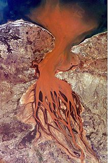
Bombetoka Bay is a bay on the northwestern coast of Madagascar near the city of Mahajanga, where the Betsiboka River flows into the Mozambique Channel. Numerous islands and sandbars have formed in the estuary from the large amount of sediment carried in by the Betsiboka River and have been shaped by the flow of the river and the push and pull of tides.

The Madagascar dry deciduous forests represent a tropical dry forest ecoregion situated in the western and northern part of Madagascar. The area has high numbers of endemic plant and animal species but has suffered large-scale clearance for agriculture. They are among the world's richest and most distinctive dry forests and included in the Global 200 ecoregions by the World Wide Fund. The area is also home to distinctive limestone karst formations known as tsingy, including the World Heritage Site of Bemaraha.

The Solomon Archipelago is a terrestrial ecoregion and marine ecoregion in the Pacific Ocean. It includes the tropical ocean waters surrounding most of Solomon Islands, and includes Bougainville Island, Buka, and the Tabar Islands of Papua New Guinea and their surrounding waters.

Tweed–Moreton, also known as the Central Eastern Shelf Transition, is a marine biogeographic region of eastern Australia.

The New Guinea mangroves is a mangrove ecoregion that covers extensive areas of the coastline New Guinea, the large island in the western Pacific Ocean north of Australia.

The Bahia mangroves is a tropical ecoregion of the mangroves biome, and the South American Atlantic Forest biome, located in Northeastern Brazil. Its conservation status is considered to be critical/endangered due to global climate change and other factors.

The Solomon Islands archipelago is an archipelago in the western South Pacific Ocean, northeast of Australia. The archipelago is in the Melanesia subregion and bioregion of Oceania and forms the eastern boundary of the Solomon Sea. The many islands of the archipelago are distributed across Papua New Guinea and Solomon Islands. The largest island in the archipelago is the Autonomous Region of Bougainville, which lies within Papua New Guinea along with Nukumanu, Buka and a number of small associated islands. Much of the remainder falls within the territory of Solomon Islands and include the atolls of Ontong Java, Sikaiana, the raised coral atolls of Rennell and Bellona, and the high islands of Choiseul, Santa Isabel, the Shortlands, New Georgia, Guadalcanal, the Nggelas, Malaita, Makira, and the most southerly significant island, Nendö within the Santa Cruz Islands.

The Angolan Scarp savanna and woodlands is an ecoregion located on the coast of Angola, an area with a variety of habitats and rich in wildlife including many endemic birds and animals.

The Gulf of Oman desert and semi-desert is a coastal ecoregion on the Persian Gulf and the Gulf of Oman in Oman and the United Arab Emirates at the northeastern tip of the Arabian Peninsula. The climate is hot and dry, with gravelly plains and savanna with thorny acacia trees inland from the coast. Along the coast there are mixture of habitats that include mangrove swamps, lagoons and mudflats. The mangrove areas are dominated by Avicennia marina and the savanna by Prosopis cineraria and Vachellia tortilis. Masirah Island is an important breeding area for the loggerhead sea turtle and other sea turtles also occur here, as well as a great variety of birds, some resident and some migratory. There are some protected areas, but in general the habitats have been degraded by the grazing of livestock, especially camels and goats; they are also at risk from oil spills, off-road driving and poaching.

The Central African mangroves ecoregion consists of the largest area of mangrove swamp in Africa, located on the coasts of West Africa, mainly in Nigeria.

The East African mangroves are a mangrove ecoregion consisting of swamps along the Indian Ocean coast of East Africa in Mozambique, Tanzania, Kenya and southern Somalia.

The Guinean mangroves are a coastal ecoregion of mangrove swamps in rivers and estuaries near the ocean of West Africa from Senegal to Sierra Leone.
The Southern Africa mangroves are mangrove ecoregion on the Mozambique's southernmost coast and the eastern coast of South Africa.

Marine habitats are habitats that support marine life. Marine life depends in some way on the saltwater that is in the sea. A habitat is an ecological or environmental area inhabited by one or more living species. The marine environment supports many kinds of these habitats. Marine habitats can be divided into coastal and open ocean habitats. Coastal habitats are found in the area that extends from as far as the tide comes in on the shoreline out to the edge of the continental shelf. Most marine life is found in coastal habitats, even though the shelf area occupies only seven percent of the total ocean area. Open ocean habitats are found in the deep ocean beyond the edge of the continental shelf.
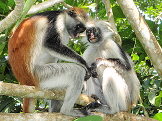
The wildlife of Zanzibar consists of terrestrial and marine flora and fauna in the archipelago of Zanzibar, an autonomous region of Tanzania. Its floral vegetation is categorized among the coastal forests of eastern Africa as the Southern Zanzibar-Inhambane coastal forest mosaic and the Northern Zanzibar-Inhambane coastal forest mosaic. Its faunal species are mostly small animals, birds, and butterflies.
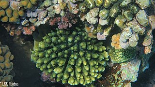
Nosy Ve-Androka National Park is a Protected Marine Area located in the southwestern part of Madagascar, south of Tulear, and 40 km south of the tourist village of Anakao. It lies between latitudes 25 ° 29/25 ° 09 South and longitudes 44 ° 50/45 ° 06 East and covers an area of 92080 ha. It is composed of Core Areas totalling 28,820 ha and Buffer Zones totalling 63,260 ha. The park is made up of eight parcels in two clusters, with part found along the coast adjacent to Tsimanampetsotsa National Park. It includes sections of the rich coral reef system of South West Madagascar in the Mozambique Channel, recognized as the third largest reef system in the world. Diversity of habitats include fringing reefs, barrier reefs, coral reef beds, seagrass area, open sea, rocky coast and sandy beaches. The Nosy Ve-Androka National Park contains about 140 species of coral and 240 species of fish. There are also rare species such as Coelacanths, marine turtle species, dugongs, dolphins and whales and sandy beaches that are used by nesting sea turtles.
The East African coral coast is a marine ecoregion along the eastern coast of Africa. It extends along the coasts of Kenya, Tanzania, and northern Mozambique, from Lamu in Kenya to Angoche in Mozambique. It adjoins the Northern Monsoon Current Coast ecoregion to the north, and the Bight of Sofala/Swamp Coast ecoregion to the south.
The Bight of Sofala/Swamp Coast is a marine ecoregion along the eastern coast of Africa, characterized by extensive mangrove swamps and coastal wetlands. It extends along the coast of Mozambique, from Angoche to the Bazaruto Archipelago. It adjoins the East African coral coast ecoregion to the north, and the Delagoa ecoregion to the south.

Delagoa is a marine ecoregion along the eastern coast of Africa. It extends along the coast of Mozambique and South Africa from the Bazaruto Archipelago to Lake St. Lucia in South Africa in South Africa's Kwazulu-Natal province. It adjoins the Bight of Sofala/Swamp Coast ecoregion to the north, and the Natal ecoregion to the south. It has Africa's southernmost tropical coral reefs and mangrove forests. It is the southernmost Indo-Pacific ecoregion, marking the transition from the tropical Indo-Pacific to Temperate Southern Africa.

The Amazonia marine ecoregion covers the coastal marine environment off the mouth of the Amazon River on the continental shelf of Brazil. The warm North Brazil Current moves east-to-west across the river's outlet, carrying turbid, fresh water to the northwest towards the Caribbean Sea. The Amazonia is one of two ecoregions in the North Brazil Shelf province, a large marine ecosystem (LME). It is thus part of the Tropical Atlantic realm.

