
Oceanic trenches are prominent, long, narrow topographic depressions of the ocean floor. They are typically 50 to 100 kilometers wide and 3 to 4 km below the level of the surrounding oceanic floor, but can be thousands of kilometers in length. There are about 50,000 km (31,000 mi) of oceanic trenches worldwide, mostly around the Pacific Ocean, but also in the eastern Indian Ocean and a few other locations. The greatest ocean depth measured is in the Challenger Deep of the Mariana Trench, at a depth of 10,920 m (35,830 ft) below sea level.
Subduction is a geological process in which the oceanic lithosphere and some continental lithosphere is recycled into the Earth's mantle at convergent boundaries. Where the oceanic lithosphere of a tectonic plate converges with the less dense lithosphere of a second plate, the heavier plate dives beneath the second plate and sinks into the mantle. A region where this process occurs is known as a subduction zone, and its surface expression is known as an arc-trench complex. The process of subduction has created most of the Earth's continental crust. Rates of subduction are typically measured in centimeters per year, with rates of convergence as high as 11 cm/year.

The Ring of Fire is a region around much of the rim of the Pacific Ocean where many volcanic eruptions and earthquakes occur. The Ring of Fire is a horseshoe-shaped belt about 40,000 km (25,000 mi) long and up to about 500 km (310 mi) wide.

A convergent boundary is an area on Earth where two or more lithospheric plates collide. One plate eventually slides beneath the other, a process known as subduction. The subduction zone can be defined by a plane where many earthquakes occur, called the Wadati–Benioff zone. These collisions happen on scales of millions to tens of millions of years and can lead to volcanism, earthquakes, orogenesis, destruction of lithosphere, and deformation. Convergent boundaries occur between oceanic-oceanic lithosphere, oceanic-continental lithosphere, and continental-continental lithosphere. The geologic features related to convergent boundaries vary depending on crust types.
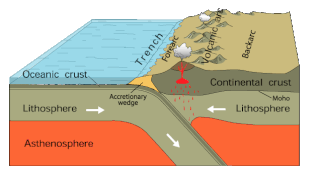
Forearc is a plate tectonic term referring to a region in a subduction zone between an oceanic trench and the associated volcanic arc. Forearc regions are present along convergent margins and eponymously form 'in front of' the volcanic arcs that are characteristic of convergent plate margins. A back-arc region is the companion region behind the volcanic arc.
Megathrust earthquakes occur at convergent plate boundaries, where one tectonic plate is forced underneath another. The earthquakes are caused by slip along the thrust fault that forms the contact between the two plates. These interplate earthquakes are the planet's most powerful, with moment magnitudes (Mw) that can exceed 9.0. Since 1900, all earthquakes of magnitude 9.0 or greater have been megathrust earthquakes.

The Ryukyu Trench, also called Nansei-Shotō Trench, is a 1398 km (868 mi) long oceanic trench located along the southeastern edge of Japan's Ryukyu Islands in the Philippine Sea in the Pacific Ocean, between northeastern Taiwan and southern Japan. The trench has a maximum depth of 7460 m (24,476 ft). The trench is the result of oceanic crust of the Philippine Plate obliquely subducting beneath the continental crust of the Eurasian Plate at a rate of approximately 52 mm/yr. In conjunction with the adjacent Nankai Trough to the northeast, subduction of the Philippine plate has produced 34 volcanoes. The largest earthquake to have been recorded along the Ryukyu Trench, the 1968 Hyūga-nada earthquake, was magnitude 7.5 and occurred along the northernmost part of the trench on 1 April 1968. This earthquake also produced a tsunami.

The Manila Trench is an oceanic trench in the Pacific Ocean, located west of the islands of Luzon and Mindoro in the Philippines. The trench reaches a depth of about 5,400 metres (17,700 ft), in contrast with the average depth of the South China Sea of about 1,500 metres (4,900 ft). It is created by subduction, in which the Sunda Plate is subducting under the Philippine Mobile Belt, producing this almost N-S trending trench. The convergent boundary is terminated to the north by the Taiwan collision zone, and to the south by the Mindoro terrane. It is an area pervaded by negative gravity anomalies.
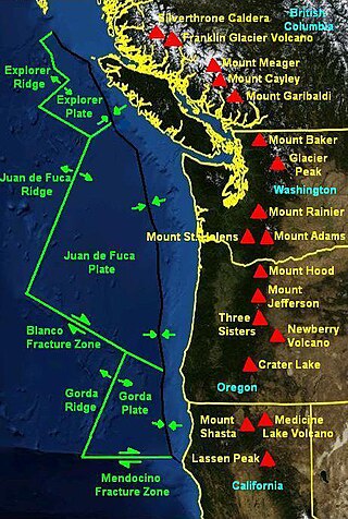
The Mendocino Triple Junction (MTJ) is the point where the Gorda plate, the North American plate, and the Pacific plate meet, in the Pacific Ocean near Cape Mendocino in northern California. This triple junction is the location of a change in the broad plate motions which dominate the west coast of North America, linking convergence of the northern Cascadia subduction zone and translation of the southern San Andreas Fault system. This region is can be characterized by transform fault movement, the San Andreas also by transform strike slip movement, and the Cascadia subduction zone by a convergent plate boundary subduction movement. The Gorda plate is subducting, towards N50ºE, under the North American plate at 2.5 – 3 cm/yr, and is simultaneously converging obliquely against the Pacific plate at a rate of 5 cm/yr in the direction N115ºE. The accommodation of this plate configuration results in a transform boundary along the Mendocino Fracture Zone, and a divergent boundary at the Gorda Ridge. This area is tectonically active historically and today. The Cascadia subduction zone is known to be capable of producing megathrust earthquakes on the order of MW 9.0.
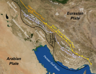
The Zagros fold and thrust belt is an approximately 1,800-kilometre (1,100 mi) long zone of deformed crustal rocks, formed in the foreland of the collision between the Arabian Plate and the Eurasian Plate. It is host to one of the world's largest petroleum provinces, containing about 49% of the established hydrocarbon reserves in fold and thrust belts (FTBs) and about 7% of all reserves globally.

In seismology, a tsunami earthquake is an earthquake which triggers a tsunami of significantly greater magnitude, as measured by shorter-period seismic waves. The term was introduced by Japanese seismologist Hiroo Kanamori in 1972. Such events are a result of relatively slow rupture velocities. They are particularly dangerous as a large tsunami may arrive at a coastline with little or no warning.
The 2013 Saravan earthquake occurred with a moment magnitude of 7.7 at 15:14 pm IRDT (UTC+4:30) on 16 April. The shock struck a mountainous area between the cities of Saravan and Khash in Sistan and Baluchestan Province, Iran, close to the border with Pakistan, with a duration of about 25 seconds. The earthquake occurred at an intermediate depth in the Arabian plate lithosphere, near the boundary between the subducting Arabian Plate and the overriding Eurasian Plate at a depth of about 80 km.
The 2013 Balochistan earthquakes took place in late September in southwestern Pakistan. The mainshock had a moment magnitude of 7.7 and a maximum Mercalli intensity of IX (Violent). At least 825 people were killed and hundreds more were injured. On 28 September, a M6.8 aftershock occurred to the north at a depth of 14.8 kilometres, killing at least 22 people.
The Sumatra Trench is a part of the Sunda Trench or Java Trench. The Sunda subduction zone is located in the east part of Indian Ocean, and is about 300 km (190 mi) from the southwest coast of Sumatra and Java islands. It extends over 5,000 km (3,100 mi) long, starting from Myanmar in the northwest and ending at Sumba Island in the southeast.
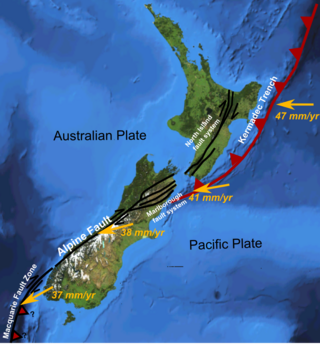
The Hikurangi Margin is New Zealand's largest subduction zone and fault.

The subduction tectonics of the Philippines is the control of geology over the Philippine archipelago. The Philippine region is seismically active and has been progressively constructed by plates converging towards each other in multiple directions. The region is also known as the Philippine Mobile Belt due to its complex tectonic setting.

An earthquake occurred off the coast of the Alaska Peninsula on July 28, 2021, at 10:15 p.m. local time. The large megathrust earthquake had a moment magnitude of 8.2 according to the United States Geological Survey (USGS). A tsunami warning was issued by the National Oceanic and Atmospheric Administration (NOAA) but later cancelled. The mainshock was followed by a number of aftershocks, including three that were of magnitude 5.9, 6.1 and 6.9 respectively.
The 1843 Nias earthquake off the northern coast of Sumatra, Indonesia caused severe damage when it triggered a tsunami along the coastline. The earthquake with a moment magnitude (Mw ) of 7.8 lasted nine minutes, collapsing many homes in Sumatra and Nias. It was assigned a maximum modified Mercalli intensity of XI (Extreme).

The 1867 Keelung earthquake occurred off the northern coast of Taiwan on the morning of December 18 with a magnitude of 7.0. It produced strong shaking that seriously damaged the cities of Keelung and Taipei. A tsunami, thought to be the only confirmed destructive of its kind in Taiwan, drowned hundreds and had a run-up exceeding 15 m (49 ft). The total death toll was estimated to be 580 while more than 100 were injured. It was followed by aftershocks that were felt on average ten times a day.
The Vanuatu subduction zone is currently one of the most active subduction zones on earth, producing great earthquakes, with potential for tsunami hazard to all coastlines of the Pacific ocean. There are active volcanoes associated with arc volcanism.
