Mallacoota, Victoria

Last updated

Mallacoota
Victoria
Mallacoota 1.jpg
Mallacoota
Australia Victoria East Gippsland Shire location map.svg
Red pog.svg
Mallacoota
Coordinates 37°33′0″S149°45′0″E / 37.55000°S 149.75000°E / -37.55000; 149.75000
Population1,183 (2021 census) [1]
Postcode(s) 3892
Elevation22 m (72 ft)
Location
LGA(s) Shire of East Gippsland
State electorate(s) Gippsland East
Federal division(s) Gippsland
Mean max tempMean min tempAnnual rainfall
19.6 °C
67 °F
10.9 °C
52 °F
897.0 mm
35.3 in
Mallacoota Camping Park Mallacoota 2.JPG
Mallacoota Camping Park
Mallacoota Lake sunset Mallacoota3.jpg
Mallacoota Lake sunset

Mallacoota is a small town in the East Gippsland region in the state of Victoria, Australia. At the 2021 census, Mallacoota had a population of 1,183. At holiday times, particularly Easter and Christmas, the population increases by about 8,000. It is the last official township on Victoria's east coast before the border with New South Wales. Mallacoota has a regional airport (Mallacoota Airport) YMCO (XMC) consisting of a gravel runway for light planes and an asphalt runway for commercial planes flying from Melbourne. [2]

Contents

It is a popular holiday spot for boating, fishing, walking the wilderness coast, swimming, birdwatching, and surfing. The Mallacoota Arts Council runs events throughout each year. Mallacoota Inlet is one of the main villages along the wilderness coastal walk from New South Wales to Victoria, and Gipsy Point is located at the head of the inlet.

History

Prehistory the area was part of the territory of the Bidawal people. Shore-based whaling may have taken place in the area in 1841 under the direction of Captain John Stevenson. [3]

Settlers started to arrive in the 1830s. A small timber lighthouse was installed on nearby Gabo Island in 1854, and the existing granite lighthouse was completed in 1862. By the 1880s commercial fishing was well established, with some catch being shipped south to Melbourne. At the same time the first tourists started to arrive. Gold was discovered in 1894, after which the Spotted Dog Mine operated for three years[ citation needed ]. Mallacoota Post Office opened on 7 May 1894 and Mallacoota West in 1901. In 1928 Mallacoota West was renamed Mallacoota, and Mallacoota became Mallacoota East (closing in 1940). [4] A satellite airfield was constructed during World War II for the purpose of coastal defence. During the 20th century the logging, farming and fishing industries in the area declined, and the tourism and abalone industries grew. The town's largest employer, the abalone co-operative, was formed in 1967.

In December 2019, fires in the East Gippsland region had a "significant impact" on Mallacoota and the nearby town of Genoa. [5]

Geography

Mallacoota is one of the most isolated towns in the state of Victoria, 25 kilometres (16 mi) off the Princes Highway and 523 kilometres (325 mi) and six hours from Melbourne. It is 526 kilometres (327 mi) and seven hours from Sydney, New South Wales. It is halfway between Melbourne and Sydney when travelling via Princes Highway, though that is a long route between Australia's two main cities.[ citation needed ]

It is known for its wild flowers, abalone industry, the inlet estuary consisting of Top Lake and Bottom Lake, and Croajingolong National Park that surround it.[ citation needed ]

Gipsy Point is located at the head of Mallacoota Inlet, and is especially known for its bird life. [6]

Sport

Golfers play at the course of the Mallacoota Golf and Country Club on Nelson Drive. [7]

The Sydney Swans' 2005 premiership winning defender and former St Kilda player Sean Dempster hails from Mallacoota. [8]

Mallacoota has a soccer club called the Mallacoota Blues. The club ranging from junior age groups to senior age groups plays in the Far South Coast Football Association (FSCFA). Mallacoota is also the host to the annual Mallacoota Cup soccer tournament.

Whale watchings for migrating and residential species such as the endemic, endangered Burrunan dolphins, southern right whales, and humpback whales, are available on many locations along the coasts in their migration seasons.

Fishing competitions are also popular in the town of Mallacoota with many being held on weekends throughout the year.[ citation needed ] These weekends help to support individual businesses with the number of people that visit the small town.[ citation needed ]

2019-2020 bushfires

[9]

Cause

On the late afternoon of 28 December, a lightning strike near Wingan River started a bushfire which burned southward towards the coast, roughly 40 km away despite mild conditions and little wind. Expected wind changes and catastrophic fire conditions predicted for the days to follow highlighted the risk to the township if the fire remained uncontrolled.

Warnings

Evacuation warnings were given to the potential fire impact area of East Gippsland at 3:00 pm on 28 December resulting in over 30,000 holidaymakers exiting the East Gippsland region in the days to follow. Mallacoota and Cann River were excluded at that time from the warnings. Three Country Fire Authority (CFA) strike teams, about 95 volunteer firefighters with 18 tankers and three command vehicles, were sent to the town immediately after the fire started on 28 December to assist the local CFA brigade and other emergency services, they arrived in the town early night the same day. Local emergency services estimated 10,000 people were in the town at the time the CFA strike teams arrived, including up to 2,000 residents. At 1:00 pm on 29 December a "watch and act" notified residents it was too late to leave, stranding thousands in town after the Princes Highway to Melbourne was closed. This was despite roads to New South Wales being safe to travel. At 8:34 pm on 29 December the roads to Melbourne were reopened but the emergency warnings continued to advise people in the township it was safest to stay. The official emergency warning advice remained that it was safest to remain in Mallacoota despite all exits being available as there was a reasonable estimate of roads, mainly the one towards Melbourne, being impacted if the predicted conditions developed suddenly. On 30 December at 11:00 am, local authorities alerted residents and visitors of the fire-front and shelter plans during an announced makeshift township meeting, not everyone in town chose to attend the meeting despite it being widely announced. The general advice through the meeting was that those wanting to leave could do so, but only via the North to Eden and Canberra, this still deterred many of the residents and visitors that attended the meeting from evacuating. The roads were officially closed two hours after the meeting and the estimate was of 1,000 residents and 3,000 visitors still in the township for the remainder of the incident.

Impact

A southwest wind change pushed the fire through the Croajingolong National Park towards the town, roughly 60 km from the point of ignition within a few hours during the early hours of 31 December as a control line could not be established by Fire Management Victoria due to rough terrain and aircraft suppression was also unsuccessful the previous two days. An emergency warning was given at 4:40 pm on 30 December for all to relocate to a safe evacuation location. This was the local hall or the wharf. Many boat owners launched their boats into the water and sheltered on the lake. It is reported that more than 50 boat owners with up to 300 people were on the lake on the evening of 30 December. The town was evacuated towards the main wharf, and into the hall, directly east of Mallacoota Airport and stayed there for over 24 hours. Aircraft suppression could not be committed on 31 December as the fire created its own weather system and thermal imaging of the fire could not be obtained accurately due to the thick layered smoke plume generated by the fire which turned day into night during the morning of that day at the location. At approximately 8:00 am on 31 December a firestorm reached the industrial area of the township with the fire-front itself estimated to have been around 10 km wide, to which the CFA responded. Large sections of the town were lost during the hours that followed (mainly in Genoa Road and Terra Nova Drive) with over 135 homes destroyed and many others damaged, but the central areas of the town where people were sheltering and most of the town's significant infrastructure was saved from the fire-front which passed and continued its path North North East towards the border with New South Wales. The CFA and other emergency services personnel continued to work well into the morning of 1 January. No human fatalities were recorded.

Post fires

Despite the immediate threat passing, the fires continued to burn in and around the town. In the late afternoon of 31 December people started to leave their shelters and return to their houses. Many areas of the town were cut off from direct access due to active fires, including Mirrabooka Road and Lakeside Drive. In the early hours of the morning of 1 January thick smoke engulfed the town resulting in a panicked community seeking medical assistance and evacuation. This resulted in over 200 medical presentations to the Medical Centre in a single day and stores of Ventolin inhalers being depleted with the local pharmacy supplies being exhausted before the arrival of the fires. The CFA strike teams (personnel only) were extracted by air around mid-day on 1 January as fresh replacements could safely be deployed at “shift-change”.

Evacuation

On 2 January the Royal Australian Navy arrived in Mallacoota bringing a small supply of essential medical supplies and 8000 litres of diesel fuel. On 3 January it commenced the large civil evacuation due to hundreds of kilometres of the damaged road preventing access to Mallacoota and surrounding towns. Nearly 1000 people and pets were evacuated on HMAS Choules with a 20-hour trip to Hastings. There was far fewer than the initially estimated numbers, with as few as 3,000 people in the region at the time the fires hit. A further 450 people were evacuated by the Royal Australian Air Force once visibility allowed for air evacuation.

On 5 January the fires threatening Mallacoota were feared to have joined up with the Batemans Bay fires and were threatening the town of Eden, New South Wales.

Recovery

Roads for residents opened on the 18 January to allow them to cross the border to New South Wales to buy supplies. The Australia Day weekend provided an opportunity for campers and visitors to return in convoys to collect their belongings, but were required to leave immediately. By 6 February all roads into Mallacoota were opened.

Climate

Mallacoota has an oceanic climate (Cfb) according to Köppen system. Unusually warm winter temperatures can be caused by the foehn effect, which typically occurs on the region's coastal plains. [10]

Climate data for Mallacoota (1991–2020 averages, 1974–2022 extremes)
MonthJanFebMarAprMayJunJulAugSepOctNovDecYear
Record high °C (°F)42.0
(107.6)
41.6
(106.9)
36.9
(98.4)
37.2
(99.0)
26.7
(80.1)
22.2
(72.0)
23.5
(74.3)
26.6
(79.9)
35.2
(95.4)
36.2
(97.2)
40.7
(105.3)
41.6
(106.9)
42.0
(107.6)
Mean daily maximum °C (°F)24.3
(75.7)
24.0
(75.2)
22.5
(72.5)
20.2
(68.4)
17.6
(63.7)
15.4
(59.7)
15.0
(59.0)
15.7
(60.3)
17.5
(63.5)
19.2
(66.6)
20.9
(69.6)
22.3
(72.1)
19.6
(67.3)
Mean daily minimum °C (°F)15.8
(60.4)
15.7
(60.3)
14.3
(57.7)
11.8
(53.2)
9.3
(48.7)
7.3
(45.1)
6.3
(43.3)
6.4
(43.5)
8.3
(46.9)
10.0
(50.0)
12.2
(54.0)
13.8
(56.8)
10.9
(51.6)
Record low °C (°F)6.8
(44.2)
6.6
(43.9)
6.5
(43.7)
4.0
(39.2)
2.4
(36.3)
0.7
(33.3)
0.4
(32.7)
0.5
(32.9)
0.7
(33.3)
2.9
(37.2)
3.2
(37.8)
5.6
(42.1)
0.4
(32.7)
Average precipitation mm (inches)62.8
(2.47)
70.0
(2.76)
70.6
(2.78)
84.5
(3.33)
75.8
(2.98)
96.5
(3.80)
80.4
(3.17)
65.9
(2.59)
68.5
(2.70)
73.3
(2.89)
80.3
(3.16)
68.6
(2.70)
897.0
(35.31)
Average precipitation days8.99.09.710.913.215.213.812.812.712.411.19.7139.4
Average relative humidity (%)66696667686965636465656666
Source 1: Bureau of Meteorology, Mallacoota (1991–2020) [11]
Source 2: Bureau of Meteorology, Mallacoota (all years) [12]

Notable people

Related Research Articles

<span class="mw-page-title-main">Croajingolong National Park</span> Protected area in Victoria, Australia

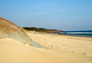
The Croajingolong National Park is a coastal national park located in the East Gippsland region of the Australian state of Victoria. The 88,355-hectare (218,330-acre) national park is situated approximately 450 kilometres (280 mi) east of Melbourne and 500 kilometres (310 mi) south of Sydney.

<span class="mw-page-title-main">Ash Wednesday bushfires</span> 1983 brushfires in Australia

The Ash Wednesday bushfires, known in South Australia as Ash Wednesday II, were a series of bushfires that occurred in south-eastern Australia in 1983 on 16 February, the Christian holy day Ash Wednesday. Within twelve hours, more than 180 fires fanned by hot winds of up to 110 km/h (68 mph) caused widespread destruction across the states of Victoria and South Australia. Years of severe drought and extreme weather combined to create one of Australia's worst fire days in a century. The fires were the deadliest bushfire in Australian history until the Black Saturday bushfires in 2009.

<span class="mw-page-title-main">Heyfield, Victoria</span> Town in Victoria, Australia

Heyfield is a town in Victoria, Australia, with a population of 1,993. It is 206 kilometres (128 mi) east of Melbourne, in the Shire of Wellington local government area. Located on the Thomson River, Heyfield is a gateway to the Victorian High Country.

<span class="mw-page-title-main">East Gippsland</span> Region of Victoria, Australia

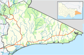
East Gippsland is the eastern region of Gippsland, Victoria, Australia covering 31,740 square kilometres (14%) of Victoria. It has a population of 80,114.

<span class="mw-page-title-main">Genoa, Victoria</span> Town in Victoria, Australia

Genoa is a town in Eastern Gippsland, Victoria, Australia. It is close to the New South Wales border where the Princes Highway crosses the Genoa River. The town is an important access point to the Croajingolong National Park. At the 2021 census, Genoa had a population of 66. The Genoa Post Office opened on 9 April 1888.

<span class="mw-page-title-main">Wingan Inlet</span>

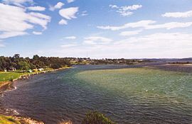
Wingan Inlet is an inlet within the Croajingolong National Park, in the East Gippsland region of Victoria, Australia.

The Cann River is a perennial river located in the East Gippsland region of the Australian state of Victoria.

<span class="mw-page-title-main">Floods in Australia</span>

Australia has had over 160,708 floods in the last 10 years, many of which have taken out homes, wildlife and many habitats.

<span class="mw-page-title-main">Shire of Orbost</span> Local government area in Victoria, Australia

The Shire of Orbost was a local government area about 380 kilometres (236 mi) east of Melbourne, the state capital of Victoria, Australia. The shire covered an area of 9,347 square kilometres (3,608.9 sq mi), and existed from 1892 until 1994.

Johnsonville is a town in the East Gippsland region of Victoria, Australia. It is located on the Princes Highway 18.9 km east from the city of Bairnsdale and 18.3 km west from the tourist resort and fishing port of Lakes Entrance. The town encompasses an area of approximately 5,617 hectares, 56 square kilometres or 13,879 acres.

<span class="mw-page-title-main">2008–09 Australian bushfire season</span>

The Australian bushfire season ran from late December 2008 to April/May 2009. Above average rainfalls in December, particularly in Victoria, delayed the start of the season, but by January 2009, conditions throughout South eastern Australia worsened with the onset of one of the region's worst heat waves. On 7 February, extreme bushfire conditions precipitated major bushfires throughout Victoria, involving several large fire complexes, which continued to burn across the state for around one month. 173 people lost their lives in these fires and 414 were injured. 3,500+ buildings were destroyed, including 2,029 houses, and 7,562 people displaced.

<span class="mw-page-title-main">Bushfires in Victoria</span>

The state of Victoria in Australia has had a long history of catastrophic bushfires, the most deadly of these, the Black Saturday bushfires of 2009 claiming 173 lives. Legislation, planning, management and suppression are the responsibilities of the Victorian State Government through its departments and agencies including the Country Fire Authority (CFA) and the Department of Environment, Land, Water and Planning (DELWP).

<span class="mw-page-title-main">Black Saturday bushfires</span> Series of deadly bushfires throughout Victoria State, Australia in early 2009

The Black Saturday bushfires were a series of bushfires that either ignited or were already burning across the Australian state of Victoria on and around Saturday, 7 February 2009, and were one of Australia's all-time worst bushfire disasters. The fires occurred during extreme bushfire weather conditions and resulted in Australia's highest-ever loss of human life from a bushfire, with 173 fatalities. Many people were left homeless as a result.

<span class="mw-page-title-main">2009–10 Australian bushfire season</span>

A bushfire season occurred predominantly from June 2009 to May 2010. Increased attention has been given to this season as authorities and government attempt to preempt any future loss of life after the Black Saturday bushfires during the previous season, 2008–09. Long range weather observations predict very hot, dry and windy weather conditions during the summer months, leading to a high risk of bushfire occurrence.

The 2009 Victorian Bushfires Royal Commission is a Victorian Royal Commission that concluded on 31 July 2010 that investigated the circumstances surrounding the Black Saturday bushfires on Saturday 7 February 2009 which caused 173 fatalities.

The 2010 Victorian floods were a widespread series of flood events across the state of Victoria, Australia. The floods, which followed heavy rain across southeastern Australia in early September 2010, caused the inundation of about 250 homes, hundreds of evacuations and millions of dollars of damage. Weather warnings were initially issued for Victoria on Thursday 2 September and rain began to fall on the Friday, continuing through the weekend to Tuesday. Heavy rain fell in most regions of the state, particularly at higher altitudes in the state's west and northeast, flooding the upper reaches of many of Victoria's major rivers. A state of emergency was declared with State Emergency Service crews arriving from Queensland, South Australia and Tasmania. The floods proceeded an extensive drought period that had effected the entirety of Australia.

<span class="mw-page-title-main">2010–11 Australian bushfire season</span>

During the summer of 2010–11, a relative lack of bushfires occurred along Eastern Australia due to a very strong La Niña effect, which instead contributed to severe flooding, in particular the 2010–11 Queensland floods and the 2011 Victorian floods. As a result of these weather patterns, most major fire events took place in Western Australia and South Australia. Some later significant fire activity occurred in Gippsland in eastern Victoria, an area which largely missed the rainfall that lead to the flooding in other parts of the state.

The Teal Creek, formerly known as Little River, is a perennial stream of the Genoa River catchment, located in the East Gippsland region of the Australian state of Victoria.

<span class="mw-page-title-main">2019–20 Australian bushfire season</span> Major natural disaster

The 2019–20 Australian bushfire season or Black Summer was one of the most intense and catastrophic fire seasons on record in Australia. It included a period of bushfires in many parts of Australia, which, due to its unusual intensity, size, duration, and uncontrollable dimension, was considered a megafire by media at the time. Exceptionally dry conditions, a lack of soil moisture, and early fires in Central Queensland led to an early start to the bushfire season, beginning in June 2019. Hundreds of fires burnt, mainly in the southeast of the country, until May 2020. The most severe fires peaked from December 2019 to January 2020.

Wingan River is a locality in the Shire of East Gippsland, Victoria, Australia. It is situated on the river of the same name. In the 2016 census, Wingan River had a population of zero.

References

  1. Australian Bureau of Statistics (28 June 2022). "Mallacoota". 2021 Census QuickStats. Retrieved 1 April 2023. OOjs UI icon edit-ltr-progressive.svg
  2. YMCO – Mallacoota  (PDF). AIP En Route Supplement from Airservices Australia , effective 2023-11-30, Aeronautical Chart
  3. Susan Chamberlain, Sealing, whaling & early settlement of Victoria; An annotated bibliography of historical sources, Victorian Archaeological Survey & the Department of Conservation & Environment, Melbourne, 1989, pp. 10, 14.
  4. Phoenix Auctions History, Post Office List , retrieved 12 March 2021
  5. "Properties destroyed, four people missing as bushfires tear through Victoria". Abc.net.au. 30 December 2019. Retrieved 24 November 2021.
  6. "Gipsy Point on the Sydney Melbourne Coastal Drive". Sydney Melboune Touring. 1 March 2021. Retrieved 1 March 2021.
  7. "Mallacoota Golf & Country Club". Golfselect.com.au. Retrieved 24 November 2021.
  8. "Mallacoota man plays in Swans grand final". Abc.net.au. 23 September 2005. Retrieved 24 November 2021.
  9. "A first-hand account of the Mallacoota fire - CFA News and Media". Archived from the original on 15 January 2020. Retrieved 15 February 2020.
  10. Weather map explainer: What are cold fronts, synoptic charts, isobars? by Debra Killalea from News.com.au. July 22, 2016. Retrieved November 15, 2021
  11. "Mallacoota 1991–2020 averages". Bureau of Meteorology. Retrieved 19 April 2022.
  12. "Mallacoota all years". Bureau of Meteorology. Retrieved 19 April 2022.