The Northern Anatolian conifer and deciduous forests is a temperate coniferous forests ecoregion located in northern Anatolia, Turkey.

The Eastern Mediterranean conifer-sclerophyllous-forests, also known as the Eastern Mediterranean conifer-forests, is an ecoregion in the eastern Mediterranean Basin. It covers portions of Turkey, Syria, Iraq, Lebanon, Israel, Palestinian territories, Jordan, and Saudi Arabia.

The Mediterranean woodlands and forests is an ecoregion in the coastal plains, hills, and mountains bordering the Mediterranean Sea and Atlantic Ocean in North Africa. It has a Mediterranean climate, and is in the Mediterranean forests, woodlands, and scrub biome.

Mediterranean conifer and mixed forests is an ecoregion, in the temperate coniferous forest biome, which occupies the high mountain ranges of North Africa. The term is also a botanically recognized plant association in the African and Mediterranean literature.
The temperate rainforests of the Russian Far East are within the Russian federal subjects Primorsky Krai and Khabarovsk Krai and contains the Sikhote-Alin mountain range. Found within the Russian Federation, this area is one of the most productive and diverse forests in the world and also contains one of the highest endangered species densities on Earth. While most temperate rainforests around the world have retained only a fraction of their historical range, these forests maintain the majority of their former range and almost all of their historical biodiversity. The region is also notable for having what has become the last remaining large tract of viable habitat for the critically endangered Amur tiger and Amur leopard.

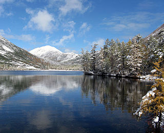
Zov Tigra National Park, is a mountainous refuge for the endangered Amur Tiger. The park encompasses an area of 83,384 hectares on the southeast coast of Russia's Far East in the federal district Primorsky Krai. The park is about 100 km northeast of Vladivostok, on both the eastern and western slopes of the southern Sikhote-Alin mountain range, a range that runs north-south through the Primorsky Krai. The relatively warm waters of the Sea of Japan are to the east, the Korean peninsula to the south, and China to the West. The terrain in rugged and difficult to access, with heavily forested taiga coexisting with tropical species of animals and birds. The park is relatively isolated from human development, and functions as a conservation reserve. Tourists may visit the portions of the park marked for recreation, but entry to the protected zones is only possible in the company of park rangers.

Anyuysky National Park covers the basin of the Anyuy River, on the west slope of the Central Sikhote-Alin Mountain range in the Russian Far East. The Anyuy flows west into the Amur River, the main river of the region, as it flows northeast into the Sea of Okhotsk. The park is important because it creates an ecological corridor from the low floodplain of the Amur, to the high forested mountains of the Sikhote-Alin. The park is in the Nanaysky District in Khabarovsk Krai, about 50 miles downstream of the city of Khabarovsk. The area is remote, with few towns and sparse population. The area has historically depended on salmon fishing, logging, and hunting. The local indigenous people are the Nanai people, representing about a quarter of the nearby settlements.

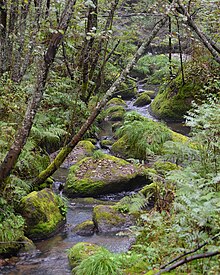
Udegeyskaya Legenda National Park covers the richest coniferous-deciduous forest on the western slope of the Central Sikhote-Alin mountains of the Russian Far East. The Sikhote-Alin is a range that runs north-south through Primorsky Krai. The park is designed to protect west-slope river valley habitat, and to support the remnant of the indigenous Udege people. The area is known for abundant fishing and boating on the streams and rivers. It is also a refuge for the endangered Amur tiger. The park is roughly midway between the city of Vladivostok, and Khabarovsk. The relatively warm waters of the Sea of Japan are to the east, the Korean peninsula to the south, and China to the West.

Bikin National Park was created on November 3, 2015 to protect the largest remaining old-growth mixed forest in the Northern Hemisphere, as well as the territory of 10% of all Amur tigers in the wild. The park was also created for the purpose of protecting the forest culture of the 600 indigenous inhabitants of the Bikin River Basin living in the territory - Udeghes and Nanai people. Because of its size for pristine forest, and its characterization as a "temperate rain forest", it has an important status as a center for biodiversity of both plants and animals. The park sits in the administrative region of Pozharsky District, in Primorsky Krai in the Russian Far East on the west slope of the Sikhote-Alin mountains. The Bikin River Valley is also a World Heritage site.
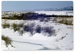
Khingan Nature Reserve is a Russian 'zapovednik', located in the extreme south-east of the Amur River region of the Russian Far East. The reserve covers two types of habitat: the flat Arkharinskaya lowlands with abundant wetlands, and forested spurs of the Lesser Khingan mountains. In particular, Khingan Reserve was created to protect steppe and forest-steppe landscapes, and nesting sites of the endangered Red-crowned crane and the vulnerable White-naped crane. The reserve is situated in the Arkharinsky District of Amur Oblast.

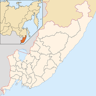
Bastak Nature Reserve is a Russian 'zapovednik' located in the Amur River basin in the Russian Far East. The reserve's territory covers the south-eastern spurs Bureya Range and the northern outskirts of the Sredneamurskaya lowlands. The reserve is situated in about 10 km north of the city of Birobidzhan in the Birobidzhansky District, and is the only national reserve in the Jewish Autonomous Oblast.

Ussurisky Nature Reserve is a Russian 'zapovednik' that protects one of the remaining virgin mixed deciduous-conifer forests in the Primorsky (Maritime) region of the Russian Far East. The mountainous terrain is located on a southern spur of the Sikhote-Alin Mountains, in the upper reaches of the Komarovka River, about 50 km northeast of the city of Vladivostok. The reserve is named after Vladimir L. Komarov, an important early botanist and early explorer of the Primorsky region. The Ussursisky Reserve is situated in the Shkotovsky District of Primorsky Krai.
The Okhotsk-Manchurian taiga ecoregion is an area of coniferous forests in the Russian Far East, covering the Amur River delta, the west coast of the Okhotsk Sea, and the rugged extension of the northern Sikhote-Alin Mountains that run southwest-to-northeast through the Primorsky and Khabarovsk regions. It is the southernmost taiga forest in Eurasia. The ecoregion is distinguished from surrounding ecoregions by the slightly warmer climate due to the maritime influence and the shield of the mountains to the west, and by the mixing of flora and fauna species from Okhotsk-Kamchatka communities to the north and Manchurian species from the south. The forest at lower altitudes is "light taiga", and "dark taiga" at higher altitudes.

The Da Hinggan-Dzhagdy Mountains conifer forests ecoregion covers the Greater Khingan Mountains of Northeast China, and across the border north into the Russian Far East where it follows the mountain ridge for another 500 km to the east. The mountain forests exhibit a floral community called "Daurian flora", a combination of the Siberian taiga to the north and the Manchurian floral types to the south. The eastern slopes are steep and drained by many rivers, the western slopes are gentler, and there are grasslands on some slopes. The ecoregion is in the Palearctic realm, with a subarctic climate. It covers 35,199,998 km2 (13,590,795 sq mi).

The Ussuri broadleaf and mixed forests ecoregion covers a mountainous areas above the lower Amur River and Ussuri River in Primorsky Krai and Khabarovsk Krai in the Russian Far East. The ecoregion is in the Palearctic realm, with a Humid Continental climate. It covers 187,357 km2 (72,339 sq mi).

The Northeast China Plain deciduous forests ecoregion covers the flat interior Northeast China Plain and neighboring adjacent northwestern North Korea, in the region historically known as Manchuria. The plain is surrounded by mountains on the north and east, and supports some of China's largest forest tracts. There are also extensive low-lying wetlands, which support important bird populations.

The Changbai Mountains mixed forests ecoregion covers the Changbai Mountains and surrounding foothills in China and North Korea. The region features extensive and naturally preserved deciduous and conifer forests. The region exhibits high biodiversity due to its relative isolation, temperate climate with high rainfall, and centrality to central Chinese, Siberian, and European floral communities. In 1979, a significant portion of the ecoregion was designated the Changbaishan Biosphere Reserve by UNESCO.

The Central Korea deciduous forests is a temperate broadleaf and mixed forests ecoregion on the Korean Peninsula, covering portions of South Korea and North Korea.
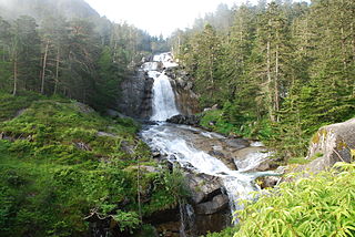
The Pyrenees conifer and mixed forests is a temperate broadleaf and mixed forests ecoregion in southwestern Europe. It extends along the Pyrenees mountains which run east and west along the border between France and Spain, and includes all Andorra. The ecoregion extends from the lower slopes of the Pyrenees to its highest peaks, which include Aneto, Posets, and Vignemale.

The Alps conifer and mixed forests is a temperate broadleaf and mixed forests ecoregion in central Europe. It extends along the Alps mountains through portions of France, Italy, Switzerland, Germany, Liechtenstein, Austria, and Slovenia. The ecoregion extends from the lower slopes of the Alps to its peaks, which include Mont Blanc, at 4,809 m (15,778 ft) the highest peak in the Alps.