Manda Island

Last updated

Manda Island
TakwaArch.jpg
Takwa Ruins Mihrab
Geography
ArchipelagoLamu Archipelago
Administration
Kenya

Manda is an island of the Lamu Archipelago of Kenya, known for the prosperous 9th century ports of Takwa and Manda town. The island is now linked by ferry to Lamu and is home to Manda Airport, while Manda Toto island lies to its west. The island is separated from the mainland by the narrow Mkanda channel.

Contents

Both Manda town and Takwa were probably abandoned due to lack of water in the first half of the 19th century. In the 1960s the Kenya Department of Agriculture recommended building several concrete catchments called jabias to capture rain water on the island. Two jabias were built and many families moved onto the island, farming maize, cassava, simsim and cotton. [1]

Manda town

History

The Manda town ruins (on the Northwest coast of Manda Island), were first explored by the archaeologist Neville Chittick in 1965. The town owes its origins to trade with the Persian Gulf during 9th and 10th centuries . The chief trading commodity was probably elephant ivory. mangrove poles were probably also important. Early inhabitants of Manda constructed buildings with burnt square brick and stone and set with a lime mortar. These building techniques are found only on islands and coastal areas of Kenya. This brick and mortar technology is unique to the previously mentioned areas [2] whereas the bricks averaging about 18 cm (7") (which "match perfectly ...in measure") are unique for East Africa for this period, and are likely to have been brought in from Sohar, in modern-day Oman. These bricks probably arrived on Manda Island as ballast in sailing ships entering the port. [3] From the mid-9th century to the early 11th century buildings were also constructed from coral known as coral rag cut from dead coral reefs.

The large scale excavations in 1966, 1970, and 1978 revealed an prosperity unrivaled in East Africa for the period. Signs of this prosperity include Chinese porcelain dating from the ninth century onward, Islamic pottery and glass, and local pottery dated by the associated imports. . [4] Chittick defines 7 periods for occupation of Manda Island: Mid-9th to early 11th century, Mid-11th to late 13th century, late 13th to 14th century, 15th and early 16th century, Mid-16th to 17th century, and Post-seventeenth century. [4] A striking feature of the town are large sea walls built sometime between the 9th century to the 13th century. The walls parallel the shore and are built from large coral blocks. These walls were likely constructed to reclaim sections of the shoreline. Running parallel with the sea with returns running inland, these walls built from large coral blocks are deduced to have been constructed partly to reclaim sections of the shore, and partly to consolidate the edges of the peninsula.

In the July 2013 issue of Archeology it was reported that a Chinese "Yongle Tongbao" cash coin was found on Manda Island, illustrating the reach of Chinese explorers and traders. The coin was issued during the reign of the Yongle Emperor, Zhu Di which lasted until 1424.

At its peak, the town covered some 40 acres (160,000 m2) and its population is estimated to have been about 3,500. [5] Manda prospered until the 13th century when it began to decline.

Ancient DNA analysis has been completed for 3 buried Manda Island individuals in order to determine the proportions of "African-like, Persian-like, and Indian-like" DNA sequences. [6] The location of the analyzed burials next to mosques is indicative of an elite status in the Manda society. The individuals were dated to between 1400-1500 AD. Analysis was completed of the individual's mitochondrial DNA (mtDNA), autosomal DNA, Y chromosome DNA, and X chromosome DNA. Analysis of mtDNA, demonstrating maternal ancestry patterns, showed a L* haplotype. The L* haplotype is predominantly found in present-day Sub-Saharan African populations. Y chromosome analysis, demonstrating paternal ancestry patterns, showed that the individual was carrying the J2 haplotype, found more frequently in Southwest Asian or Persian individuals compared to Sub-Saharan African individuals. X chromosomes, containing larger maternal influence, was compared with the 22 autosomal chromosomes, which contain equal maternal and paternal influence. X chromosomes contained more indicators of African ancestry compared to autosomal DNA, further adding to evidence of African ancestry on the maternal side and Persian or Southeast Asian ancestry on the paternal side. The proportion of female African DNA from the samples analyzed was quantified by the authors to be 100%.

Introduction of foreign DNA was estimated to have occurred between 795-1085 AD. However, the authors indicate that this likely occurred over "multiple generations" and that mixture of Eurasian and African populations have continually occurred since. [6]

Takwa

The Takwa Ruins was a town in the period 1500-1700, and it was designated a Kenyan National Monument in 1982.

Manda Airport

Manda Airport is the only civilian airport in the Lamu Archipelago.

See also

Notes

  1. Martin, 1973, p. 27
  2. Chittick, 1984, p. 217
  3. Chittick, 1984, p. 15
  4. 1 2 Chittick, 1984, p.11-12
  5. Martin, 1973, p. 26
  6. 1 2 Brielle, Esther S.; Fleisher, Jeffrey; Wynne-Jones, Stephanie; Sirak, Kendra; Broomandkhoshbacht, Nasreen; Callan, Kim; Curtis, Elizabeth; Iliev, Lora; Lawson, Ann Marie; Oppenheimer, Jonas; Qiu, Lijun; Stewardson, Kristin; Workman, J. Noah; Zalzala, Fatma; Ayodo, George (March 2023). "Entwined African and Asian genetic roots of medieval peoples of the Swahili coast". Nature. 615 (7954): 866–873. doi:10.1038/s41586-023-05754-w. ISSN   1476-4687. PMC   10060156 .

Related Research Articles

<span class="mw-page-title-main">Kilwa Kisiwani</span> Island, hamlet and an archaeological Swahili city-state site of Lindi Region, Tanzania.

Kilwa Kisiwani is an island, national historic site, and hamlet community located in the township of Kilwa Masoko, the district seat of Kilwa District in the Tanzanian region of Lindi Region in southern Tanzania. Kilwa Kisiwani is the largest of the nine hamlets in the town Kilwa Masoko and is also the least populated hamlet in the township with less than 1,000 residents.

The Swahili people comprise mainly Bantu, Afro-Arab and Comorian ethnic groups inhabiting the Swahili coast, an area encompassing the Zanzibar archipelago and mainland Tanzania's seaboard, littoral Kenya, northern Mozambique, the Comoros Islands, southwestern Somalia and Northwest Madagascar.

<span class="mw-page-title-main">Lamu</span> Town in Lamu County, Kenya

Lamu or Lamu Town is a small town on Lamu Island, which in turn is a part of the Lamu Archipelago in Kenya. Situated 341 kilometres (212 mi) by road northeast of Mombasa that ends at Mokowe Jetty, from where the sea channel has to be crossed to reach Lamu Island. It is the headquarters of Lamu County and a UNESCO World Heritage Site.

<span class="mw-page-title-main">Zanj</span> Name used by medieval Muslim geographers to refer to a portion of Southeast Africa

Zanj was a name used by medieval Muslim geographers to refer to both a certain portion of Southeast Africa and to its Bantu inhabitants. This word is also the origin of the place-names Zanzibar and the Sea of Zanj.

A genealogical DNA test is a DNA-based genetic test used in genetic genealogy that looks at specific locations of a person's genome in order to find or verify ancestral genealogical relationships, or to estimate the ethnic mixture of an individual. Since different testing companies use different ethnic reference groups and different matching algorithms, ethnicity estimates for an individual vary between tests, sometimes dramatically.

<span class="mw-page-title-main">Pate Island</span> Kenyan island in the Indian Ocean

Pate (Paté) Island is located in the Indian Ocean close to the northern coast of Kenya, to which it belongs. It is the largest island in the Lamu Archipelago, which lie between the towns of Lamu and Kiunga in the former Coast Province. The island is almost completely surrounded by mangroves.

<span class="mw-page-title-main">Lamu Archipelago</span> Kenyan Archipelago on the Indian Ocean

The Lamu Archipelago is located in the Indian Ocean close to the northern coast of Kenya, to which it belongs. The islands lie between the towns of Lamu and Kiunga, near the Coast Province. It is a part of Lamu District.

<span class="mw-page-title-main">Lamu Island</span>

Lamu Island is a port, city, and island just off the shore of Kenya in the Indian Ocean approximately 150 miles from Mombasa. It is a part of the East African country of Kenya. Lamu was founded in the 12th century. Lamu is one of the longest-established and best-preserved remaining settlements of the Swahili tradition in east Africa that remains today. The island has continually been inhabited for over seven hundred years, and continues to be an important center in eastern Africa.

The Shirazis of the Comoros, 138,000 people with Iranian heritage, are one of the largest ethnic group inhabiting the archipelago nation of Comoros near the east African coast and they represent 17% of the total population of the Comoros. Their origins are linked to Shiraz and the southwestern coastal region of Persia. 89,000 people or 11% of the population from the Comoros have Southeast Asian ancestry. The Shirazi people are notable for helping establish Sunni Islam in Comoros, and the wealth they accumulated from trading commodities and slaves.

<span class="mw-page-title-main">Swahili architecture</span> Building traditions of the eastern and southeastern coasts of Africa

Swahili architecture is a term used to designate a whole range of diverse building traditions practiced or once practiced along the eastern and southeastern coasts of Africa. Rather than simple derivatives of Islamic architecture from the Arabic world, Swahili stone architecture is a distinct local product as a result of evolving social and religious traditions, environmental changes, and urban development.

<span class="mw-page-title-main">Swahili culture</span> Culture of the Swahili people in Africa

Swahili culture is the culture of the Swahili people inhabiting the Swahili coast. This littoral area encompasses Tanzania, Kenya, and Mozambique, as well as the adjacent islands of Zanzibar and Comoros along with some parts of Malawi and the eastern part of Democratic Republic of Congo. They speak Swahili as their native language, which belongs to the Bantu language family. Graham Connah described Swahili culture as at least partially urban, mercantile,and literate.

<span class="mw-page-title-main">Bajuni people</span> Bantu ethnic group

The Bajuni people are a Bantu ethnic group who live primarily in the Bajuni Islands of Somalia and coastal areas between the port city of Kismayo and the city of Mombasa in Kenya.

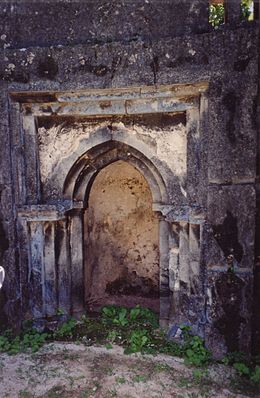
The Takwa settlement is situated on the south side of Manda Island, in the Lamu District in the coastal province of Kenya. They are the ruins of a town which was abandoned around the 18th century.

<span class="mw-page-title-main">Mtwapa</span> Place in Kilifi County, Kenya

Mtwapa is a town located in Kenya's Kilifi County. It is situated 16 kilometres (10 mi) north of Mombasa on the Mombasa-Malindi road. It is close to the Mombasa Marine National Park and Reserve and Jumba la Mtwana. Two informal settlements in Mtwapa, Majengo and Mzambarauni, are participating in the UN-HABITAT Participatory Slum Upgrading Program. It is run by resident committees and aims to provide every household with drinking water and a toilet.

Genetic studies on Jews are part of the population genetics discipline and are used to analyze the chronology of Jewish migration accompanied by research in other fields, such as history, linguistics, archaeology, and paleontology. These studies investigate the origins of various Jewish ethnic divisions. In particular, they examine whether there is a common genetic heritage among them. The medical genetics of Jews are studied for population-specific diseases.

<span class="mw-page-title-main">Siyu</span> Place in Coast Province, Kenya

Siyu is a settlement on the north coast of Pate Island, within the Lamu Archipelago in Kenya's Coast Province.

The Shirazi people, also known as Mbwera, are a Bantu ethnic group inhabiting the Swahili coast and the nearby Indian ocean islands. They are particularly concentrated on the islands of Zanzibar, Pemba and Comoros.

<span class="mw-page-title-main">Shirazi era</span>

The "Shirazi era" refers to a mythic origin in the history of Southeast Africa, between the 13th century and 15th century, as recorded in the 15th century Kilwa Chronicle. Many Swahili in the central coastal region claim that their towns were founded by Persians from the Shiraz region in the 13th century.

<span class="mw-page-title-main">Haplogroup E-M2</span> Human Y-chromosome DNA haplogroup

Haplogroup E-M2, also known as E1b1a1-M2, is a human Y-chromosome DNA haplogroup. E-M2 is primarily distributed within sub-Saharan Africa. More specifically, E-M2 is the predominant subclade in West Africa, Central Africa, Southern Africa, and the region of the African Great Lakes; it also occurs at low to moderate frequencies in North Africa, and at low frequencies in the Middle East. E-M2 has several subclades, but many of these subhaplogroups are included in either E-L485 or E-U175. E-M2 is especially common among indigenous Africans who speak Niger-Congo languages, and was spread to Southern Africa and East Africa through the Bantu expansion.

<span class="mw-page-title-main">Genetic history of Africa</span>

The genetic history of Africa is composed of the overall genetic history of African populations in Africa, including the regional genetic histories of North Africa, West Africa, East Africa, Central Africa, and Southern Africa, as well as the recent origin of modern humans in Africa. The Sahara served as a trans-regional passageway and place of dwelling for people in Africa during various humid phases and periods throughout the history of Africa.

References

Further reading

2°16′S40°58′E / 2.267°S 40.967°E / -2.267; 40.967