Mantle plume

Last updated
A superplume generated by cooling processes in the mantle (LVZ = low-velocity zone) Lower Mantle Superplume.PNG
A superplume generated by cooling processes in the mantle (LVZ = low-velocity zone)

A mantle plume is a proposed mechanism of convection within the Earth's mantle, hypothesized to explain anomalous volcanism. [2] Because the plume head partially melts on reaching shallow depths, a plume is often invoked as the cause of volcanic hotspots, such as Hawaii or Iceland, and large igneous provinces such as the Deccan and Siberian Traps. Some such volcanic regions lie far from tectonic plate boundaries, while others represent unusually large-volume volcanism near plate boundaries.

Contents

Concepts

Mantle plumes were first proposed by J. Tuzo Wilson in 1963 [3] [4] and further developed by W. Jason Morgan in 1971 and 1972. [4] A mantle plume is posited to exist where super-heated material forms (nucleates) at the core-mantle boundary and rises through the Earth's mantle. Rather than a continuous stream, plumes should be viewed as a series of hot bubbles of material. [5] Reaching the brittle upper Earth's crust they form diapirs. [6] These diapirs are "hotspots" in the crust. In particular, the concept that mantle plumes are fixed relative to one another and anchored at the core-mantle boundary would provide a natural explanation for the time-progressive chains of older volcanoes seen extending out from some such hotspots, for example, the Hawaiian–Emperor seamount chain. However, paleomagnetic data show that mantle plumes can also be associated with Large Low Shear Velocity Provinces (LLSVPs) [7] [8] and do move relative to each other. [9]

The current mantle plume theory is that material and energy from Earth's interior are exchanged with the surface crust in two distinct and largely independent convective flows:

The plume hypothesis was simulated by laboratory experiments in small fluid-filled tanks in the early 1970s. [12] Thermal or compositional fluid-dynamical plumes produced in that way were presented as models for the much larger postulated mantle plumes. Based on these experiments, mantle plumes are now postulated to comprise two parts: a long thin conduit connecting the top of the plume to its base, and a bulbous head that expands in size as the plume rises. The entire structure resembles a mushroom. The bulbous head of thermal plumes forms because hot material moves upward through the conduit faster than the plume itself rises through its surroundings. In the late 1980s and early 1990s, experiments with thermal models showed that as the bulbous head expands it may entrain some of the adjacent mantle into itself.

The size and occurrence of mushroom mantle plumes can be predicted by the transient instability theory of Tan and Thorpe. [13] [14] The theory predicts mushroom-shaped mantle plumes with heads of about 2000 km diameter that have a critical time (time from onset of heating of the lower mantle to formation of a plume) of about 830 million years for a core mantle heat flux of 20 mW/m2, while the cycle time (the time between plume formation events) is about 2000 million years. [15] The number of mantle plumes is predicted to be about 17.

When a plume head encounters the base of the lithosphere, it is expected to flatten out against this barrier and to undergo widespread decompression melting to form large volumes of basalt magma. It may then erupt onto the surface. Numerical modelling predicts that melting and eruption will take place over several million years. [16] These eruptions have been linked to flood basalts, although many of those erupt over much shorter time scales (less than 1 million years). Examples include the Deccan traps in India, the Siberian traps of Asia, the Karoo-Ferrar basalts/dolerites in South Africa and Antarctica, the Paraná and Etendeka traps in South America and Africa (formerly a single province separated by opening of the South Atlantic Ocean), and the Columbia River basalts of North America. Flood basalts in the oceans are known as oceanic plateaus, and include the Ontong Java plateau of the western Pacific Ocean and the Kerguelen Plateau of the Indian Ocean.

The narrow vertical conduit, postulated to connect the plume head to the core-mantle boundary, is viewed as providing a continuous supply of magma to a hotspot. As the overlying tectonic plate moves over this hotspot, the eruption of magma from the fixed plume onto the surface is expected to form a chain of volcanoes that parallels plate motion. [17] The Hawaiian Islands chain in the Pacific Ocean is the archetypal example. It has recently been discovered that the volcanic locus of this chain has not been fixed over time, and it thus joined the club of the many type examples that do not exhibit the key characteristic originally proposed. [18]

The eruption of continental flood basalts is often associated with continental rifting and breakup. This has led to the hypothesis that mantle plumes contribute to continental rifting and the formation of ocean basins.

Chemistry, heat flow and melting

Hydrodynamic simulation of a single "finger" of the Rayleigh-Taylor instability, a possible mechanism for plume formation. In the third and fourth frame in the sequence, the plume forms a "mushroom cap". Note that the core is at the top of the diagram and the crust is at the bottom. HD-Rayleigh-Taylor.gif
Hydrodynamic simulation of a single "finger" of the Rayleigh–Taylor instability, a possible mechanism for plume formation. In the third and fourth frame in the sequence, the plume forms a "mushroom cap". Note that the core is at the top of the diagram and the crust is at the bottom.
Earth cross-section showing location of upper (3) and lower (5) mantle, D''-layer (6), and outer (7) and inner (9) core Earth-crust-cutaway-numbered.svg
Earth cross-section showing location of upper (3) and lower (5) mantle, D″-layer (6), and outer (7) and inner (9) core

The chemical and isotopic composition of basalts found at hotspots differs subtly from mid-ocean-ridge basalts. [20] These basalts, also called ocean island basalts (OIBs), are analysed in their radiogenic and stable isotope compositions. In radiogenic isotope systems the originally subducted material creates diverging trends, termed mantle components. [21] Identified mantle components are DMM (depleted mid-ocean ridge basalt (MORB) mantle), HIMU (high U/Pb-ratio mantle), EM1 (enriched mantle 1), EM2 (enriched mantle 2) and FOZO (focus zone). [22] [23] This geochemical signature arises from the mixing of near-surface materials such as subducted slabs and continental sediments, in the mantle source. There are two competing interpretations for this. In the context of mantle plumes, the near-surface material is postulated to have been transported down to the core-mantle boundary by subducting slabs, and to have been transported back up to the surface by plumes. In the context of the Plate hypothesis, subducted material is mostly re-circulated in the shallow mantle and tapped from there by volcanoes.

Stable isotopes like Fe are used to track processes that the uprising material experiences during melting. [24]

The processing of oceanic crust, lithosphere, and sediment through a subduction zone decouples the water-soluble trace elements (e.g., K, Rb, Th) from the immobile trace elements (e.g., Ti, Nb, Ta), concentrating the immobile elements in the oceanic slab (the water-soluble elements are added to the crust in island arc volcanoes). Seismic tomography shows that subducted oceanic slabs sink as far as the bottom of the mantle transition zone at 650 km depth. Subduction to greater depths is less certain, but there is evidence that they may sink to mid-lower-mantle depths at about 1,500  km depth.

The source of mantle plumes is postulated to be the core-mantle boundary at 3,000  km depth. [25] Because there is little material transport across the core-mantle boundary, heat transfer must occur by conduction, with adiabatic gradients above and below this boundary. The core-mantle boundary is a strong thermal (temperature) discontinuity. The temperature of the core is approximately 1,000 degrees Celsius higher than that of the overlying mantle. Plumes are postulated to rise as the base of the mantle becomes hotter and more buoyant.

Plumes are postulated to rise through the mantle and begin to partially melt on reaching shallow depths in the asthenosphere by decompression melting. This would create large volumes of magma. This melt rises to the surface and erupts to form hotspots.

The lower mantle and the core

Calculated Earth's temperature vs. depth. Dashed curve: Layered mantle convection; Solid curve: Whole mantle convection. Earth temperature.PNG
Calculated Earth's temperature vs. depth. Dashed curve: Layered mantle convection; Solid curve: Whole mantle convection.

The most prominent thermal contrast known to exist in the deep (1000 km) mantle is at the core-mantle boundary at 2900 km. Mantle plumes were originally postulated to rise from this layer because the hotspots that are assumed to be their surface expression were thought to be fixed relative to one another. This required that plumes were sourced from beneath the shallow asthenosphere that is thought to be flowing rapidly in response to motion of the overlying tectonic plates. There is no other known major thermal boundary layer in the deep Earth, and so the core-mantle boundary was the only candidate.

The base of the mantle is known as the D″ layer, a seismological subdivision of the Earth. It appears to be compositionally distinct from the overlying mantle and may contain partial melt.

Two very broad, large low-shear-velocity provinces exist in the lower mantle under Africa and under the central Pacific. It is postulated that plumes rise from their surface or their edges. [27] Their low seismic velocities were thought to suggest that they are relatively hot, although it has recently been shown that their low wave velocities are due to high density caused by chemical heterogeneity. [28] [29]

Evidence for the theory

Some common and basic lines of evidence cited in support of the theory are linear volcanic chains, noble gases, geophysical anomalies, and geochemistry.

Linear volcanic chains

The age-progressive distribution of the Hawaiian-Emperor seamount chain has been explained as a result of a fixed, deep-mantle plume rising into the upper mantle, partly melting, and causing a volcanic chain to form as the plate moves overhead relative to the fixed plume source. [25] Other hotspots with time-progressive volcanic chains behind them include Réunion, the Chagos-Laccadive Ridge, the Louisville Ridge, the Ninety East Ridge and Kerguelen, Tristan, and Yellowstone.

While there is evidence that the chains listed above are time-progressive, it has been shown that they are not fixed relative to one another. The most remarkable example of this is the Emperor chain, the older part of the Hawaii system, which was formed by migration of the hotspot in addition to the plate motion. [30] Another example is the Canary Islands in the northeast of Africa in the Atlantic Ocean. [31] [32]

Noble gas and other isotopes

Helium-3 is a primordial isotope that formed in the Big Bang. Very little is produced, and little has been added to the Earth by other processes since then. [33] Helium-4 includes a primordial component, but it is also produced by the natural radioactive decay of elements such as uranium and thorium. Over time, helium in the upper atmosphere is lost into space. Thus, the Earth has become progressively depleted in helium, and 3He is not replaced as 4He is. As a result, the ratio 3He/4He in the Earth has decreased over time.

Unusually high 3He/4He have been observed in some, but not all, hotspots. This is explained by plumes tapping a deep, primordial reservoir in the lower mantle, where the original, high 3He/4He ratios have been preserved throughout geologic time. [34]

Other elements, e.g. osmium, have been suggested to be tracers of material arising from near to the Earth's core, in basalts at oceanic islands. However, so far conclusive proof for this is lacking. [35]

Geophysical anomalies

Diagram showing a cross section though the Earth's lithosphere (in yellow) with magma rising from the mantle (in red). The crust may move relative to the plume, creating a track. Hotspot(geology)-1.svg
Diagram showing a cross section though the Earth's lithosphere (in yellow) with magma rising from the mantle (in red). The crust may move relative to the plume, creating a track.

The plume hypothesis has been tested by looking for the geophysical anomalies predicted to be associated with them. These include thermal, seismic, and elevation anomalies. Thermal anomalies are inherent in the term "hotspot". They can be measured in numerous different ways, including surface heat flow, petrology, and seismology. Thermal anomalies produce anomalies in the speeds of seismic waves, but unfortunately so do composition and partial melt. As a result, wave speeds cannot be used simply and directly to measure temperature, but more sophisticated approaches must be taken.

Seismic anomalies are identified by mapping variations in wave speed as seismic waves travel through Earth. A hot mantle plume is predicted to have lower seismic wave speeds compared with similar material at a lower temperature. Mantle material containing a trace of partial melt (e.g., as a result of it having a lower melting point), or being richer in Fe, also has a lower seismic wave speed and those effects are stronger than temperature. Thus, although unusually low wave speeds have been taken to indicate anomalously hot mantle beneath hotspots, this interpretation is ambiguous. [36] The most commonly cited seismic wave-speed images that are used to look for variations in regions where plumes have been proposed come from seismic tomography. This method involves using a network of seismometers to construct three-dimensional images of the variation in seismic wave speed throughout the mantle. [37]

Seismic waves generated by large earthquakes enable structure below the Earth's surface to be determined along the ray path. Seismic waves that have traveled a thousand or more kilometers (also called teleseismic waves) can be used to image large regions of Earth's mantle. They also have limited resolution, however, and only structures at least several hundred kilometers in diameter can be detected.

Seismic tomography images have been cited as evidence for a number of mantle plumes in Earth's mantle. [38] There is, however, vigorous on-going discussion regarding whether the structures imaged are reliably resolved, and whether they correspond to columns of hot, rising rock. [39]

The mantle plume hypothesis predicts that domal topographic uplifts will develop when plume heads impinge on the base of the lithosphere. An uplift of this kind occurred when the north Atlantic Ocean opened about 54 million years ago. Some scientists have linked this to a mantle plume postulated to have caused the breakup of Eurasia[ citation needed ] and the opening of the north Atlantic, now suggested to underlie Iceland. Current research has shown that the time-history of the uplift is probably much shorter than predicted, however. It is thus not clear how strongly this observation supports the mantle plume hypothesis.

Geochemistry

Basalts found at oceanic islands are geochemically distinct from mid-ocean ridge basalt (MORB). Ocean island basalt (OIB) is more diverse compositionally than MORB, and the great majority of ocean islands are composed of alkali basalt enriched in sodium and potassium relative to MORB. Larger islands, such as Hawaii or Iceland, are mostly tholeiitic basalt, with alkali basalt limited to late stages of their development, but this tholeiitic basalt is chemically distinct from the tholeiitic basalt of mid-ocean ridges. OIB tends to be more enriched in magnesium, and both alkali and tholeiitic OIB is enriched in trace incompatible elements, with the light rare earth elements showing particular enrichment compared with heavier rare earth elements. Stable isotope ratios of the elements strontium, neodymium, hafnium, lead, and osmium show wide variations relative to MORB, which is attributed to the mixing of at least three mantle components: HIMU with a high proportion of radiogenic lead, produced by decay of uranium and other heavy radioactive elements; EM1 with less enrichment of radiogenic lead; and EM2 with a high 87Sr/86Sr ratio. Helium in OIB shows a wider variation in the 3He/4He ratio than MORB, with some values approaching the primordial value. [40]

The composition of ocean island basalts is attributed to the presence of distinct mantle chemical reservoirs formed by subduction of oceanic crust. These include reservoirs corresponding to HUIMU, EM1, and EM2. These reservoirs are thought to have different major element compositions, based on the correlation between major element compositions of OIB and their stable isotope ratios. Tholeiitic OIB is interpreted as a product of a higher degree of partial melting in particularly hot plumes, while alkali OIB is interpreted as a product of a lower degree of partial melting in smaller, cooler plumes. [40]

Seismology

In 2015, based on data from 273 large earthquakes, researchers compiled a model based on full waveform tomography, requiring the equivalent of 3 million hours of supercomputer time. [41] Due to computational limitations, high-frequency data still could not be used, and seismic data remained unavailable from much of the seafloor. [41] Nonetheless, vertical plumes, 400 C hotter than the surrounding rock, were visualized under many hotspots, including the Pitcairn, Macdonald, Samoa, Tahiti, Marquesas, Galapagos, Cape Verde, and Canary hotspots. [42] They extended nearly vertically from the core-mantle boundary (2900 km depth) to a possible layer of shearing and bending at 1000 km. [41] They were detectable because they were 600–800 km wide, more than three times the width expected from contemporary models. [41] Many of these plumes are in the large low-shear-velocity provinces under Africa and the Pacific, while some other hotspots such as Yellowstone were less clearly related to mantle features in the model. [43]

The unexpected size of the plumes leaves open the possibility that they may conduct the bulk of the Earth's 44 terawatts of internal heat flow from the core to the surface, and means that the lower mantle convects less than expected, if at all. It is possible that there is a compositional difference between plumes and the surrounding mantle that slows them down and broadens them. [41]

Suggested mantle plume locations

An example of plume locations suggested by one recent group. Figure from Foulger (2010). CourtHotspots.png
An example of plume locations suggested by one recent group. Figure from Foulger (2010).

Mantle plumes have been suggested as the source for flood basalts. [45] [46] These extremely rapid, large scale eruptions of basaltic magmas have periodically formed continental flood basalt provinces on land and oceanic plateaus in the ocean basins, such as the Deccan Traps, [47] the Siberian Traps [48] the Karoo-Ferrar flood basalts of Gondwana, [49] and the largest known continental flood basalt, the Central Atlantic magmatic province (CAMP). [50]

Many continental flood basalt events coincide with continental rifting. [51] This is consistent with a system that tends toward equilibrium: as matter rises in a mantle plume, other material is drawn down into the mantle, causing rifting. [51]

Alternative hypotheses

In parallel with the mantle plume model, two alternative explanations for the observed phenomena have been considered: the plate hypothesis and the impact hypothesis.

The plate hypothesis

An illustration of competing models of crustal recycling and the fate of subducted slabs. The plume hypothesis invokes deep subduction (right), while the plate hypothesis focuses on shallow subduction (left). Models of mantle dynamics.jpg
An illustration of competing models of crustal recycling and the fate of subducted slabs. The plume hypothesis invokes deep subduction (right), while the plate hypothesis focuses on shallow subduction (left).

Beginning in the early 2000s, dissatisfaction with the state of the evidence for mantle plumes and the proliferation of ad hoc hypotheses drove a number of geologists, led by Don L. Anderson, Gillian Foulger, and Warren B. Hamilton, to propose a broad alternative based on shallow processes in the upper mantle and above, with an emphasis on plate tectonics as the driving force of magmatism. [52]

The plate hypothesis suggests that "anomalous" volcanism results from lithospheric extension that permits melt to rise passively from the asthenosphere beneath. It is thus the conceptual inverse of the plume hypothesis because the plate hypothesis attributes volcanism to shallow, near-surface processes associated with plate tectonics, rather than active processes arising at the core-mantle boundary.

Lithospheric extension is attributed to processes related to plate tectonics. These processes are well understood at mid-ocean ridges, where most of Earth's volcanism occurs. It is less commonly recognised that the plates themselves deform internally, and can permit volcanism in those regions where the deformation is extensional. Well-known examples are the Basin and Range Province in the western USA, the East African Rift valley, and the Rhine Graben. Under this hypothesis, variable volumes of magma are attributed to variations in chemical composition (large volumes of volcanism corresponding to more easily molten mantle material) rather than to temperature differences.

While not denying the presence of deep mantle convection and upwelling in general, the plate hypothesis holds that these processes do not result in mantle plumes, in the sense of columnar vertical features that span most of the Earth's mantle, transport large amounts of heat, and contribute to surface volcanism. [36] :277

Under the umbrella of the plate hypothesis, the following sub-processes, all of which can contribute to permitting surface volcanism, are recognised: [36]

The impact hypothesis

In addition to these processes, impact events such as ones that created the Addams crater on Venus and the Sudbury Igneous Complex in Canada are known to have caused melting and volcanism. In the impact hypothesis, it is proposed that some regions of hotspot volcanism can be triggered by certain large-body oceanic impacts which are able to penetrate the thinner oceanic lithosphere, and flood basalt volcanism can be triggered by converging seismic energy focused at the antipodal point opposite major impact sites. [53] Impact-induced volcanism has not been adequately studied and comprises a separate causal category of terrestrial volcanism with implications for the study of hotspots and plate tectonics.

Comparison of the hypotheses

In 1997 it became possible using seismic tomography to image submerging tectonic slabs penetrating from the surface all the way to the core-mantle boundary. [54]

For the Hawaii hotspot, long-period seismic body wave diffraction tomography provided evidence that a mantle plume is responsible, as had been proposed as early as 1971. [55] For the Yellowstone hotspot, seismological evidence began to converge from 2011 in support of the plume model, as concluded by James et al., "we favor a lower mantle plume as the origin for the Yellowstone hotspot." [56] [57] Data acquired through Earthscope, a program collecting high-resolution seismic data throughout the contiguous United States has accelerated acceptance of a plume underlying Yellowstone. [58] [59]

Although there is thus strong evidence that at least these two deep mantle plumes rise from the core-mantle boundary, confirmation that other hypotheses can be dismissed may require similar tomographic evidence for other hotspots.

See also

Related Research Articles

Seismic tomography or seismotomography is a technique for imaging the subsurface of the Earth with seismic waves produced by earthquakes or explosions. P-, S-, and surface waves can be used for tomographic models of different resolutions based on seismic wavelength, wave source distance, and the seismograph array coverage. The data received at seismometers are used to solve an inverse problem, wherein the locations of reflection and refraction of the wave paths are determined. This solution can be used to create 3D images of velocity anomalies which may be interpreted as structural, thermal, or compositional variations. Geoscientists use these images to better understand core, mantle, and plate tectonic processes.

<span class="mw-page-title-main">Hotspot (geology)</span> Volcanic region hotter than the surrounding mantle

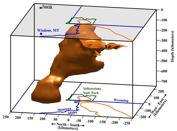
In geology, hotspots are volcanic locales thought to be fed by underlying mantle that is anomalously hot compared with the surrounding mantle. Examples include the Hawaii, Iceland, and Yellowstone hotspots. A hotspot's position on the Earth's surface is independent of tectonic plate boundaries, and so hotspots may create a chain of volcanoes as the plates move above them.

<span class="mw-page-title-main">Large igneous province</span> Huge regional accumulation of igneous rocks

A large igneous province (LIP) is an extremely large accumulation of igneous rocks, including intrusive and extrusive, arising when magma travels through the crust towards the surface. The formation of LIPs is variously attributed to mantle plumes or to processes associated with divergent plate tectonics. The formation of some of the LIPs in the past 500 million years coincide in time with mass extinctions and rapid climatic changes, which has led to numerous hypotheses about causal relationships. LIPs are fundamentally different from any other currently active volcanoes or volcanic systems.

<span class="mw-page-title-main">Iceland hotspot</span> Hotspot partly responsible for volcanic activity forming the Iceland Plateau and island

The Iceland hotspot is a hotspot which is partly responsible for the high volcanic activity which has formed the Iceland Plateau and the island of Iceland.

<span class="mw-page-title-main">East African Rift</span> Active continental rift zone in East Africa

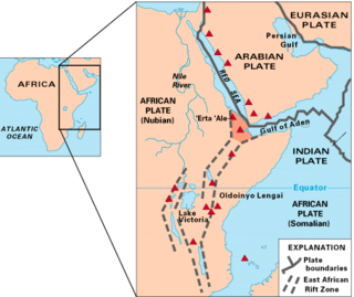
The East African Rift (EAR) or East African Rift System (EARS) is an active continental rift zone in East Africa. The EAR began developing around the onset of the Miocene, 22–25 million years ago. It was formerly considered to be part of a larger Great Rift Valley that extended north to Asia Minor.

<span class="mw-page-title-main">Mantle convection</span> Gradual movement of the planets mantle

Mantle convection is the very slow creep of Earth's solid silicate mantle as convection currents carry heat from the interior to the planet's surface. Mantle convection causes tectonic plates to move around the Earth's surface.

<span class="mw-page-title-main">East Australia hotspot</span>

The East Australia hotspot is a volcanic province in southeast Australia which includes the Peak Range in central Queensland, the Main Range on the Queensland-New South Wales border, Tweed Volcano in New South Wales, and the Newer Volcanics Province (NVP) in Victoria and South Australia. A number of the volcanoes in the province have erupted since Aboriginal settlement. The most recent eruptions were about 5,600 years ago, and memories of them survive in Aboriginal folklore. These eruptions formed the volcanoes Mount Schank and Mount Gambier in the NVP. There have been no eruptions on the Australian mainland since European settlement.

<span class="mw-page-title-main">New England hotspot</span> Volcanic hotspot in the North Atlantic Ocean

The New England hotspot, also referred to as the Great Meteor hotspot and sometimes the Monteregian hotspot, is a volcanic hotspot in the North Atlantic Ocean. It created the Monteregian Hills intrusions in Montreal and Montérégie, the White Mountains intrusions in New Hampshire, the New England and Corner Rise seamounts off the coast of North America, and the Seewarte Seamounts east of the Mid-Atlantic Ridge on the African Plate, the latter of which include its most recent eruptive center, the Great Meteor Seamount. The New England, Great Meteor, or Monteregian hotspot track has been used to estimate the movement of the North American Plate away from the African Plate from the early Cretaceous period to the present using the fixed hotspot reference frame.

<span class="mw-page-title-main">Ninety East Ridge</span> Linear ridge on the Indian Ocean floor near the 90th meridian

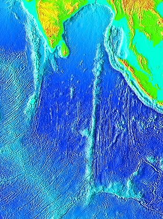
The Ninety East Ridge is a mid-ocean ridge on the Indian Ocean floor named for its near-parallel strike along the 90th meridian at the center of the Eastern Hemisphere. It is approximately 5,000 kilometres (3,100 mi) in length and can be traced topographically from the Bay of Bengal southward towards the Southeast Indian Ridge (SEIR), though the feature continues to the north where it is hidden beneath the sediments of the Bengal Fan. The ridge extends between latitudes 31°S and 9°N and has an average width of 200 km.

<span class="mw-page-title-main">Eifel hotspot</span>

The Eifel hotspot is a volcanic hotspot in Western Germany. It is one of many recent volcanic formations in and around the Eifel mountain range and includes the volcanic field known as Volcanic Eifel. Although the last eruption occurred around 10,000 years ago, the presence of escaping volcanic gases in the region indicates that it is still weakly active.

<span class="mw-page-title-main">Marquesas hotspot</span> Volcanic hotspot in the Pacific Ocean

The Marquesas hotspot is a volcanic hotspot in the southern Pacific Ocean. It is responsible for the creation of the Marquesas Islands – a group of eight main islands and several smaller ones – and a few seamounts. The islands and seamounts formed between 5.5 and 0.4 million years ago and constitute the northernmost volcanic chain in French Polynesia.

<span class="mw-page-title-main">Darfur Dome</span>

Darfur Dome or Darfur Volcanic Province is an area of about 100x400 km in Western Sudan. As well as its best-known and central feature, Deriba Crater, it encompasses the surrounding Marra Mountains and Tagabo Hills, both formed around 16–10 Ma, and the Meidob Hills, formed around 6.8 Ma.

<span class="mw-page-title-main">Society hotspot</span> Pacific volcanic hotspot

The Society hotspot is a volcanic hotspot in the south Pacific Ocean which is responsible for the formation of the Society Islands, an archipelago of fourteen volcanic islands and atolls spanning around 720 kilometres (450 mi) of the ocean which formed between 4.5 and <1 Ma.

<span class="mw-page-title-main">Ocean island basalt</span> Volcanic rock

Ocean island basalt (OIB) is a volcanic rock, usually basaltic in composition, erupted in oceans away from tectonic plate boundaries. Although ocean island basaltic magma is mainly erupted as basalt lava, the basaltic magma is sometimes modified by igneous differentiation to produce a range of other volcanic rock types, for example, rhyolite in Iceland, and phonolite and trachyte at the intraplate volcano Fernando de Noronha. Unlike mid-ocean ridge basalts (MORBs), which erupt at spreading centers (divergent plate boundaries), and volcanic arc lavas, which erupt at subduction zones (convergent plate boundaries), ocean island basalts are the result of intraplate volcanism. However, some ocean island basalt locations coincide with plate boundaries like Iceland, which sits on top of a mid-ocean ridge, and Samoa, which is located near a subduction zone.

The Erebus hotspot is a volcanic hotspot responsible for the high volcanic activity on Ross Island in the western Ross Sea of Antarctica. Its current eruptive zone, Mount Erebus, has erupted continuously since its discovery in 1841. Magmas of the Erebus hotspot are similar to those erupted from hotspots at the active East African Rift in eastern Africa. Mount Bird at the northernmost end of Ross Island and Mount Terror at its eastern end are large basaltic shield volcanoes that have been potassium-argon dated 3.8–4.8 and 0.8–1.8 million years old.

<span class="mw-page-title-main">Crustal recycling</span> Tectonic recycling process

Crustal recycling is a tectonic process by which surface material from the lithosphere is recycled into the mantle by subduction erosion or delamination. The subducting slabs carry volatile compounds and water into the mantle, as well as crustal material with an isotopic signature different from that of primitive mantle. Identification of this crustal signature in mantle-derived rocks is proof of crustal recycling.

<span class="mw-page-title-main">Large low-shear-velocity provinces</span> Structures of the Earths mantle

Large low-shear-velocity provinces (LLSVPs), also called large low-velocity provinces (LLVPs) or superplumes, are characteristic structures of parts of the lowermost mantle, the region surrounding the outer core deep inside the Earth. These provinces are characterized by slow shear wave velocities and were discovered by seismic tomography of deep Earth. There are two main provinces: the African LLSVP and the Pacific LLSVP, both extending laterally for thousands of kilometers and possibly up to 1,000 kilometres vertically from the core–mantle boundary. These have been named Tuzo and Jason respectively, after Tuzo Wilson and W. Jason Morgan, two geologists acclaimed in the field of plate tectonics. The Pacific LLSVP is 3,000 kilometers across and underlies four hotspots on Earth's crust that suggest multiple mantle plumes underneath. These zones represent around 8% of the volume of the mantle, or 6% of the entire Earth.

<span class="mw-page-title-main">Noronha hotspot</span>

Noronha hotspot is a hypothesized hotspot in the Atlantic Ocean. It has been proposed as the candidate source for volcanism in the Fernando de Noronha archipelago of Brazil, as well as of other volcanoes also in Brazil and even the Bahamas and the Central Atlantic Magmatic Province.

<span class="mw-page-title-main">Plate theory (volcanism)</span>

The plate theory is a model of volcanism that attributes all volcanic activity on Earth, even that which appears superficially to be anomalous, to the operation of plate tectonics. According to the plate theory, the principal cause of volcanism is extension of the lithosphere. Extension of the lithosphere is a function of the lithospheric stress field. The global distribution of volcanic activity at a given time reflects the contemporaneous lithospheric stress field, and changes in the spatial and temporal distribution of volcanoes reflect changes in the stress field. The main factors governing the evolution of the stress field are:

  1. Changes in the configuration of plate boundaries.
  2. Vertical motions.
  3. Thermal contraction.

Intraplate volcanism is volcanism that takes place away from the margins of tectonic plates. Most volcanic activity takes place on plate margins, and there is broad consensus among geologists that this activity is explained well by the theory of plate tectonics. However, the origins of volcanic activity within plates remains controversial.

References

  1. Based upon Figure 17 in Matyska, Ctirad; Yuen, David A. (2007). "Lower-mantle material properties and convection models of multiscale plumes". In Foulger, G. R.; Jurdy, D. M. (eds.). Plates, plumes, and planetary processes. Geological Society of America. p. 159. CiteSeerX   10.1.1.487.8049 . doi:10.1130/2007.2430(08). ISBN   978-0-8137-2430-0.
  2. "The question of mantle plumes". www.earthmagazine.org. Retrieved 2022-08-05.
  3. Wilson, J. Tuzo (8 June 1963). "Hypothesis of earth's behaviour". Nature. 198 (4884): 925–929. Bibcode:1963Natur.198..925T. doi:10.1038/198925a0. S2CID   28014204.
  4. 1 2 Duncan, Robert Ames; McDougall, Ian (1976). "Linear volcanism in French polynesia". Journal of Volcanology and Geothermal Research. 1 (3): 197–227. Bibcode:1976JVGR....1..197D. doi:10.1016/0377-0273(76)90008-1. hdl: 1885/140344 .
  5. Krishnamurti, Ruby; Howard, Louis N. (1981). "Large-scale flow generation in turbulent convection". Proceedings of the National Academy of Sciences. 78 (4): 1981–1985. Bibcode:1981PNAS...78.1981K. doi: 10.1073/pnas.78.4.1981 . PMC   319265 . PMID   16592996.
  6. 1 2 Larson, R.L. (1991). "Latest pulse of Earth: Evidence for a mid-Cretaceous superplume". Geology. 19 (6): 547–550. Bibcode:1991Geo....19..547L. doi:10.1130/0091-7613(1991)019<0547:LPOEEF>2.3.CO;2.
  7. French, Scott W.; Romanowicz, Barbara (2015). "Broad plumes rooted at the base of the Earth's mantle beneath major hotspots". Nature. 525 (7567): 95–99. Bibcode:2015Natur.525...95F. doi:10.1038/nature14876. ISSN   0028-0836. PMID   26333468. S2CID   205245093.
  8. Davies, D.R.; Goes, S.; Sambridge, M. (February 2015). "On the relationship between volcanic hotspot locations, the reconstructed eruption sites of large igneous provinces and deep mantle seismic structure". Earth and Planetary Science Letters. 411: 121–130. Bibcode:2015E&PSL.411..121D. doi:10.1016/j.epsl.2014.11.052.
  9. Bono, Richard K.; Tarduno, John A.; Bunge, Hans-Peter (2019-07-29). "Hotspot motion caused the Hawaiian-Emperor Bend and LLSVPs are not fixed". Nature Communications. 10 (1): 3370. Bibcode:2019NatCo..10.3370B. doi: 10.1038/s41467-019-11314-6 . ISSN   2041-1723. PMC   6662702 . PMID   31358746.
  10. Stein, M. & Hofmann, A.W. (1994). "Mantle plumes and episodic continental growth". Nature. 372 (6501): 63–68. Bibcode:1994Natur.372...63S. doi:10.1038/372063a0. S2CID   4356576.
  11. Storey, B.C. (1995). "The role of mantle plumes in continental breakup: Case histories from Gondwana". Nature. 377 (6547): 301–308. Bibcode:1995Natur.377..301S. doi:10.1038/377301a0. S2CID   4242617.
  12. Whitehead Jr., John A.; Luther, Douglas S. (1975). "Dynamics of laboratory diapir and plume models". Journal of Geophysical Research . 80 (5): 705–717. Bibcode:1975JGR....80..705W. doi:10.1029/JB080i005p00705. S2CID   129327249.
  13. Tan, K. K.; Thorpe, R. B. (1999). "The onset of convection driven by buoyancy caused by various modes of transient heat conduction, Part I: Transient Rayleigh numbers". J. Chem. Eng. Sci. 54 (2): 225–238. doi:10.1016/S0009-2509(98)00248-6.
  14. Tan, K.K. & Thorpe, R. B. (1999). "The onset of convection driven by buoyancy caused by various modes of transient heat conduction, Part II: the sizes of plumes". J. Chem. Eng. Sci. 54 (2): 239–244. Bibcode:1999ChEnS..54..239T. doi:10.1016/S0009-2509(98)00249-8.
  15. Tan, K. K.; Thorpe, R. B.; Zhao Z., Zhidan (2011). "On predicting the mantle mushroom plumes". Geoscience Frontiers. 2 (2): 223–235. Bibcode:2011GeoFr...2..223T. doi: 10.1016/j.gsf.2011.03.001 .
  16. Farnetani, C. G.; Richards, M. A. (1994). "Numerical investigations of the mantle plume initiation model for flood basalt events". J. Geophys. Res. 99 (B7): 13, 813–13, 833. Bibcode:1994JGR....9913813F. doi:10.1029/94jb00649.
  17. Skilbeck, J. N.; Whitehead, J. A. (1978). "Formation of discrete islands in linear chains". Nature . 272 (5653): 499–501. Bibcode:1978Natur.272..499S. doi:10.1038/272499a0. S2CID   33087425.
  18. Sager, William W. "Insight into Motion of the Hawaiian Hotspot from Paleomagnetism". www.MantlePlume.org. Retrieved 2011-01-10.
  19. Li, Shengtai; Li, Hui. "Parallel AMR Code for Compressible MHD or HD Equations". Los Alamos National Laboratory. Archived from the original on 2016-03-03. Retrieved 2006-09-05.
  20. White, William M. (2010). "Oceanic Island Basalts and Mantle Plumes: The Geochemical Perspective". Annual Review of Earth and Planetary Sciences. 38 (1): 133–160. Bibcode:2010AREPS..38..133W. doi:10.1146/annurev-earth-040809-152450. ISSN   0084-6597. S2CID   53070176.
  21. Hofmann, A. W. (1997). "Mantle geochemistry: the message from oceanic volcanism". Nature. 385 (6613): 219–229. Bibcode:1997Natur.385..219H. doi:10.1038/385219a0. ISSN   0028-0836. S2CID   11405514.
  22. Zindler, A (1986-01-01). "Chemical Geodynamics". Annual Review of Earth and Planetary Sciences. 14 (1): 493–571. doi:10.1146/annurev.earth.14.1.493. ISSN   0084-6597.
  23. Stracke, Andreas; Hofmann, Albrecht W.; Hart, Stan R. (2005). "FOZO, HIMU, and the rest of the mantle zoo". Geochemistry, Geophysics, Geosystems. 6 (5): n/a. Bibcode:2005GGG.....6.5007S. doi:10.1029/2004gc000824. hdl: 1912/451 . ISSN   1525-2027. S2CID   59354360.
  24. Nebel, Oliver; Sossi, Paolo A.; Bénard, Antoine; Arculus, Richard J.; Yaxley, Gregory M.; Woodhead, Jon D.; Rhodri Davies, D.; Ruttor, Saskia (2019). "Reconciling petrological and isotopic mixing mechanisms in the Pitcairn mantle plume using stable Fe isotopes". Earth and Planetary Science Letters. 521: 60–67. Bibcode:2019E&PSL.521...60N. doi:10.1016/j.epsl.2019.05.037. ISSN   0012-821X. S2CID   197568184.
  25. 1 2 Morgan, W. J. (1972). "Deep mantle convection plumes and plate motions". Bull. Am. Assoc. Pet. Geol. 56: 203–213.
  26. Condie, Kent C. (1997). Plate tectonics and crustal evolution (4th ed.). Butterworth-Heinemann. p. 5. ISBN   978-0-7506-3386-4.
  27. Niu, Yaoling (2018). "Origin of the LLSVPs at the base of the mantle is a consequence of plate tectonics – A petrological and geochemical perspective". Geoscience Frontiers. 9 (5): 1265–1278. Bibcode:2018AGUFM.T43A..02N. doi: 10.1016/j.gsf.2018.03.005 . ISSN   1674-9871.
  28. Brodholt, John P.; Helffrich, George; Trampert, Jeannot (2007). "Chemical versus thermal heterogeneity in the lower mantle: The most likely role of anelasticity". Earth and Planetary Science Letters. 262 (3–4): 429–437. Bibcode:2007E&PSL.262..429B. doi:10.1016/j.epsl.2007.07.054.
  29. Trampert, J.; Deschamps, F.; Resovsky, J.; Yuen, D. (2004). "Probabilistic tomography maps chemical heterogeneities throughout the lower mantle". Science . 306 (5697): 853–856. Bibcode:2004Sci...306..853T. doi:10.1126/science.1101996. PMID   15514153. S2CID   42531670.
  30. Tarduno, John A. (July 2007). "On the motion of Hawaii and other mantle plumes". Chemical Geology. 241 (3–4): 234–247. Bibcode:2007ChGeo.241..234T. doi:10.1016/j.chemgeo.2007.01.021.
  31. Zaczek, Kirsten; Troll, Valentin R.; Cachao, Mario; Ferreira, Jorge; Deegan, Frances M.; Carracedo, Juan Carlos; Soler, Vicente; Meade, Fiona C.; Burchardt, Steffi (2015-01-22). "Nannofossils in 2011 El Hierro eruptive products reinstate plume model for Canary Islands". Scientific Reports. 5 (1): 7945. Bibcode:2015NatSR...5E7945Z. doi: 10.1038/srep07945 . ISSN   2045-2322. PMC   4302296 . PMID   25609055.
  32. Carracedo, Juan Carlos; Troll, Valentin R. (2021-01-01), "North-East Atlantic Islands: The Macaronesian Archipelagos", in Alderton, David; Elias, Scott A. (eds.), Encyclopedia of Geology (Second Edition), Oxford: Academic Press, pp. 674–699, doi:10.1016/b978-0-08-102908-4.00027-8, ISBN   978-0-08-102909-1, S2CID   226588940 , retrieved 2021-03-29
  33. Anderson, D. L. (1998). "A model to explain the various paradoxes associated with mantle noble gas geochemistry". Proc. Natl. Acad. Sci. 95 (16): 9087–9092. Bibcode:1998PNAS...95.9087A. doi: 10.1073/pnas.95.16.9087 . PMC   21296 . PMID   9689038.
  34. Kurz, Mark (1999). "Dynamics of the Galapagos hotspot from helium isotope geochemistry". Geochimica et Cosmochimica Acta . 63 (23–24): 4139–4156. Bibcode:1999GeCoA..63.4139K. doi:10.1016/S0016-7037(99)00314-2.
  35. Scherstén, Anders. "Re-Os, Pt-Os and Hf-W isotopes and tracing the core in mantle melts". www.MantlePlume.org. Retrieved 2011-01-18.
  36. 1 2 3 4 Foulger, G. R. (2010). Plates vs. Plumes: A Geological Controversy. Wiley-Blackwell. ISBN   978-1-4051-6148-0.
  37. Ritsema, J.; van Heijst, H. J.; Woodhouse, J. H. (1999). "Complex shear wave velocity structure imaged beneath Africa and Iceland" (PDF). Science . 286 (5446): 1925–1928. doi:10.1126/science.286.5446.1925. PMID   10583949. S2CID   46160705. Archived from the original (PDF) on 2011-05-22.
  38. Montelli, R.; Nolet, G.; Dahlen, F.; Masters, G. (2006). "A catalogue of deep mantle plumes: new results from finite-frequency tomography". Geochemistry, Geophysics, Geosystems. 7 (11): n/a. Bibcode:2006GGG.....711007M. doi: 10.1029/2006GC001248 .
  39. "Banana-doughnut tomography – can it reveal plumes (better than conventional ray theory)?". www.MantlePlumes.org. Retrieved 2011-01-19.
  40. 1 2 Suetsugu, D.; Steinberger, B.; Kogiso, T. (2013). "Mantle Plumes and Hotspots". Reference Module in Earth Systems and Environmental Sciences: B9780124095489028682. doi:10.1016/B978-0-12-409548-9.02868-2. ISBN   9780124095489.
  41. 1 2 3 4 5 Eric Hand (2015-09-04). "Mantle plumes seen rising from Earth's core". Science. 349 (6252): 1032–1033. Bibcode:2015Sci...349.1032H. doi:10.1126/science.349.6252.1032. PMID   26339001.
  42. Scott W. French; Barbara Romanowicz (2015-09-03). "Broad plumes rooted at the base of the Earth's mantle beneath major hotspots". Nature. 525 (7567): 95–99. Bibcode:2015Natur.525...95F. doi:10.1038/nature14876. PMID   26333468. S2CID   205245093.
  43. Robert Sanders (2015-09-02). "CT scan of Earth links deep mantle plumes with volcanic hotspots". Berkeley News (UC Berkeley).
  44. Courtillot, V.; Davaillie, A.; Besse, J.; Stock, J. (2003). "Three distinct types of hotspots in the Earth's mantle". Earth and Planetary Science Letters. 205 (3–4): 295–308. Bibcode:2003E&PSL.205..295C. CiteSeerX   10.1.1.693.6042 . doi:10.1016/S0012-821X(02)01048-8.
  45. Richards, M.A.; Duncan, R.A.; Courtillot, V.E. (1989). "Flood basalts, and hotspot tracks: Plume heads and tails". Science. 246 (4926): 103–107. Bibcode:1989Sci...246..103R. doi:10.1126/science.246.4926.103. PMID   17837768. S2CID   9147772.
  46. Griffiths, R.W.; Campbell, I.H. (1990). "Stirring and structure in mantle plumes". Earth and Planetary Science Letters. 99 (1–2): 66–78. Bibcode:1990E&PSL..99...66G. doi:10.1016/0012-821X(90)90071-5.
  47. Duncan, R.A. & Pyle, D.G. (1988). "Rapid eruption of the Deccan flood basalts at the Cretaceous/Tertiary boundary". Nature. 333 (6176): 841–843. Bibcode:1988Natur.333..841D. doi:10.1038/333841a0. S2CID   4351454.
  48. Renne, P.R.; Basu, A.R. (1991). "Rapid eruption of the Siberian Traps flood basalts at the Permo-Triassic boundary". Science. 253 (5016): 176–179. Bibcode:1991Sci...253..176R. doi:10.1126/science.253.5016.176. PMID   17779134. S2CID   6374682.
  49. Encarnacion, J.; Fleming, T.H.; Elliot, D.H.; Eales, H.V. (1996). "Synchronous emplacement of Ferrar and Karoo dolerites and the early breakup of Gondwana". Geology. 24 (6): 535–538. Bibcode:1996Geo....24..535E. doi:10.1130/0091-7613(1996)024<0535:SEOFAK>2.3.CO;2.
  50. El Hachimi, H.; et al. (2011). "Morphology, internal architecture and emplacement mechanisms of lava flows from the Central Atlantic Magmatic Province (CAMP) of Argana Basin (Morocco)". In van Hinsbergen, D. J. J. (ed.). The formation and evolution of Africa: a synopsis of 3.8 Ga of earth history. Special Publications volume 357. Vol. 357. London: Geological Society of London. pp. 167–193. Bibcode:2011GSLSP.357..167H. doi:10.1144/SP357.9. hdl:11577/2574483. ISBN   978-1-86239-335-6. S2CID   129018987.{{cite book}}: |journal= ignored (help)
  51. 1 2 Renne, P.R.; Zhang, Z.C.; Richards, M.A.; Black, M.T.; Basu, A.R. (1995). "Synchrony and causal relations between Permian-Triassic boundary crises and Siberian flood volcanism". Science. 269 (5229): 1413–1416. Bibcode:1995Sci...269.1413R. doi:10.1126/science.269.5229.1413. PMID   17731151. S2CID   1672460.
  52. Pratt, Sara (2015-12-20). "The question of mantle plumes". EARTH Magazine. American Geosciences Institute. Archived from the original on 2019-12-07. Retrieved 2019-12-07.
  53. Hagstrum, Jonathan T. (2005). "Antipodal Hotspots and Bipolar Catastrophes: Were Oceanic Large-body Impacts the Cause?" (PDF). Earth and Planetary Science Letters . 236 (1–2): 13–27. Bibcode:2005E&PSL.236...13H. doi:10.1016/j.epsl.2005.02.020.
  54. Kerr, Richard A. (31 January 1997). "Deep-Sinking Slabs Stir the Mantle". Science. 275 (5300). AAAS: 613–615. doi:10.1126/science.275.5300.613. S2CID   129593362 . Retrieved 2013-06-13.
  55. Ji, Ying; ataf, Henri-Claude N (June 1998). "Detection of mantle plumes in the lower mantle by diffraction tomography: Hawaii". Earth and Planetary Science Letters. 159 (3–4): 99–115. Bibcode:1998E&PSL.159...99J. doi:10.1016/S0012-821X(98)00060-0.
  56. James, David E.; Fouch, Matthew J.; Carlson, Richard W.; Roth, Jeffrey B. (May 2011). "Slab fragmentation, edge flow and the origin of the Yellowstone hotspot track". Earth and Planetary Science Letters. 311 (1–2): 124–135. Bibcode:2011E&PSL.311..124J. doi:10.1016/j.epsl.2011.09.007.
  57. Schmandt, Brandon; Dueker, Kenneth; Humphreys, Eugene & Hansen, Steven (April 2012). "Hot mantle upwelling across the 660 beneath Yellowstone" (PDF). Earth and Planetary Science Letters. 331–332: 224–236. Bibcode:2012E&PSL.331..224S. doi:10.1016/j.epsl.2012.03.025.
  58. Kerr, Richard A. (June 2013). "Geophysical Exploration Linking Deep Earth and Backyard Geology". Science. 340 (6138): 1283–1285. Bibcode:2013Sci...340.1283K. doi:10.1126/science.340.6138.1283. PMID   23766309.
  59. Kerr, Richard A. (April 2013). "The Deep Earth Machine Is Coming Together". Science. 340 (6128): 22–24. Bibcode:2013Sci...340...22K. doi:10.1126/science.340.6128.22. PMID   23559231.