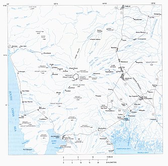
The Zambales Mountains is a mountain range on western Luzon island in the Philippines. The mountains spread along a north-south axis, separating Luzon's central plain from the South China Sea. The range extends into five provinces: Zambales, Pangasinan, Tarlac, Pampanga, and Bataan. One of its most prominent sections is known as the Cabusilan Mountain Range composed of Mount Pinatubo, Mount Negron and Mount Cuadrado, which are believed to be remnants of the ancestral Pinatubo peak. The highest elevation in the Zambales Mountains is Mount Tapulao, also known as High Peak, in Zambales province which rises to 2,037 metres (6,683 ft).

A stratovolcano, also known as a composite volcano, is a conical volcano built up by many layers (strata) of hardened lava and tephra. Unlike shield volcanoes, stratovolcanoes are characterized by a steep profile with a summit crater and periodic intervals of explosive eruptions and effusive eruptions, although some have collapsed summit craters called calderas. The lava flowing from stratovolcanoes typically cools and hardens before spreading far, due to high viscosity. The magma forming this lava is often felsic, having high to intermediate levels of silica, with lesser amounts of less viscous mafic magma. Extensive felsic lava flows are uncommon, but have traveled as far as 15 km (9 mi).

Zambales, officially the Province of Zambales, is a province in the Philippines located in the Central Luzon region. Its capital is Iba, which is located in the middle of the province. Zambales borders Pangasinan to the north and northeast, Tarlac to the east, Pampanga to the southeast, Bataan to the south and the South China Sea to the west. With a total land area of 3,830.83 square kilometres (1,479.09 sq mi), Zambales is the second largest among the seven provinces of Central Luzon after Nueva Ecija. The province is noted for its mangoes, which are abundant from January to April.
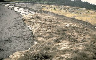
A lahar is a violent type of mudflow or debris flow composed of a slurry of pyroclastic material, rocky debris and water. The material flows down from a volcano, typically along a river valley.

The Cowlitz River is a river in the state of Washington in the United States, a tributary of the Columbia River. Its tributaries drain a large region including the slopes of Mount Rainier, Mount Adams, and Mount St. Helens.

Mount Jefferson is a stratovolcano in the Cascade Volcanic Arc, part of the Cascade Range in the U.S. state of Oregon. The second highest mountain in Oregon, it is situated within Linn County, Jefferson County, and Marion County and forms part of the Mount Jefferson Wilderness. Due to the ruggedness of its surroundings, the mountain is one of the hardest volcanoes to reach in the Cascades. It is also a popular tourist destination despite its remoteness, with recreational activities including hiking, backpacking, mountaineering, and photography. Vegetation at Mount Jefferson is dominated by Douglas fir, silver fir, mountain hemlock, ponderosa pine, lodgepole pine, and several cedar species. Carnivores, insectivores, bats, rodents, deer, birds, and various other species inhabit the area.
Mount Pinatubo is an active stratovolcano in the Zambales Mountains, located on the tripoint boundary of the Philippine provinces of Zambales, Tarlac and Pampanga, all in Central Luzon on the northern island of Luzon. Its eruptive history was unknown to most before the pre-eruption volcanic activity of early 1991. Pinatubo was heavily eroded and obscured from view by dense forests which supported a population of several thousand indigenous Aetas.
Lake breakout is the collapse of a lake, usually of high-altitude. High-altitude lakes tend to form in volcanic craters – where they are called crater lakes – or in valleys dammed as the result of earthquakes or glacial or volcanic deposition. Lake breakouts are most common a few weeks or months after a volcanic eruption as a river becomes blocked by volcanic debris.

Spirit Lake is a lake in Skamania County, Washington, United States, located north of Mount St. Helens. It was a popular tourist destination for many years until Mount St. Helens erupted in 1980. Previously there had been six camps on the shore of Spirit Lake: Boy Scout, the Girl Scout Camp at Spirit Lake, two YMCA camps, Harmony Fall Lodge, and another for the general public. There were also several lodges accessible to visitors, including Spirit Lake Lodge and Mt. St. Helens Lodge. The latter was owned and operated by Harry R. Truman, a noted victim of the volcano's 1980 eruption.
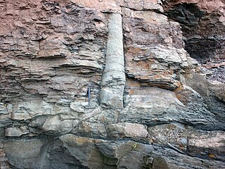
A polystrate fossil is a fossil of a single organism that extends through more than one geological stratum. The word polystrate is not a standard geological term. This term is typically found in creationist publications.

Typhoon Yunya, known in the Philippines as Typhoon Diding, was a strong tropical cyclone whose landfall in the Philippines coincided with the 1991 eruption of Mount Pinatubo. A small tropical cyclone, Yunya rapidly developed from a tropical disturbance near East Samar on June 11. By June 13 the storm had reached typhoon status as it moved west-northwest near the Philippines. Yunya attained its peak intensity the following day with estimated winds of 145 km/h (90 mph); however, strong wind shear soon impacted the typhoon and caused it to rapidly decay. The storm struck southern Luzon early on June 15 as a minimal typhoon before moving over the South China Sea later that day. After turning north and weakening to a tropical depression, the system brushed the southern tip of Taiwan on June 16 before dissipating the following day.
The Toutle River is a 17.2-mile (27.7 km) tributary of the Cowlitz River in the U.S. state of Washington. It rises in two forks merging near Toutle below Mount St. Helens and joins the Cowlitz near Castle Rock, 20 miles (32 km) upstream of the larger river's confluence with the Columbia River.

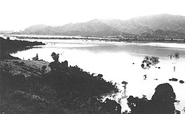
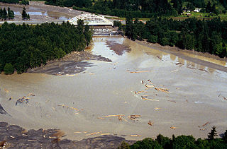
The Tarlac River is a river in Central Luzon Philippines, it is the longest tributary of the Agno River with a total length of 95.2 km (59.2 mi) covering a drainage area of 1,900 square kilometres (730 sq mi) traversing the provinces of Tarlac and Pangasinan. The river originates around the vicinity of Mount Pinatubo and empties itself into the Agno River at Poponto Swamp located between the boundaries of Tarlac and Pangasinan. It was formerly the site of traditional balsa or bamboo raft riding, until the river was heavily silted by sticky lahar or mud flow brought by the eruption of Mount Pinatubo on June 15, 1991, filling the river with over 10 feet (3.0 m) of lahar. Its main tributary is the O'Donnel River in Santa Lucia, Capas, Tarlac.

Operation Fiery Vigil was the Noncombatant Evacuation Operation (NEO) emergency evacuation of all non-essential military and U.S. Department of Defense civilian personnel and their dependents from Clark Air Base and U.S. Naval Base Subic Bay during the June 1991 eruption of Mount Pinatubo in the Republic of the Philippines.

A volcanic dam is a type of natural dam produced directly or indirectly by volcanism, which holds or temporarily restricts the flow of surface water in existing streams, like a man-made dam. There are two main types of volcanic dams, those created by the flow of molten lava, and those created by the primary or secondary deposition of pyroclastic material and debris. This classification generally excludes other, often larger and longer lived dam-type geologic features, separately termed crater lakes, although these volcanic centers may be associated with the source of material for volcanic dams, and the lowest portion of its confining rim may be considered as such a dam, especially if the lake level within the crater is relatively high.

Lake Pinatubo is the summit crater lake of Mount Pinatubo formed after its climactic eruption on June 15, 1991. The lake is located in Botolan, Zambales, near the boundaries of Pampanga and Tarlac provinces in the Philippines. It is about 90 km (56 mi) northwest of the capital city of Manila. While one paper by researchers from Japan suggested a depth of 600 m (2,000 ft), more detailed research suggests that 95–115 m (312–377 ft) is more accurate.

The 1991 eruption of Mount Pinatubo in the Philippines' Luzon Volcanic Arc was the second-largest volcanic eruption of the 20th century, behind only the 1912 eruption of Novarupta in Alaska. Eruptive activity began on April 2 as a series of phreatic explosions from a fissure that opened on the north side of Mount Pinatubo. Seismographs were set up and began monitoring the volcano for earthquakes. In late May, the number of seismic events under the volcano fluctuated from day-to-day. Beginning June 6, a swarm of progressively shallower earthquakes accompanied by inflationary tilt on the upper east flank of the mountain, culminated in the extrusion of a small lava dome.

The Muddy River is a stream, about 29 miles (47 km) long, southeast of Mount St. Helens in the U.S. state of Washington. The Muddy River flows south–southeast and joins the Lewis River just above the Swift Reservoir. The Lewis River flows west and is a tributary to the Columbia River. The east flank of Mount St. Helens is within the watershed of Muddy Creek.

Coldwater Lake is a barrier lake on the border of Cowlitz County and Skamania County, Washington in the United States. The lake was created during the 1980 eruption of Mount St. Helens, which blocked its natural outlet, Coldwater Creek, with volcanic debris. It is one of several lakes in the area that were created or otherwise enlarged by the eruption.

A volcanic crater lake is a lake in a crater that was formed by explosive activity or a collapse during a volcanic eruption.