Related Research Articles

A geographic coordinate system (GCS) is a spherical or geodetic coordinate system for measuring and communicating positions directly on Earth as latitude and longitude. It is the simplest, oldest and most widely used type of the various spatial reference systems that are in use, and forms the basis for most others. Although latitude and longitude form a coordinate tuple like a cartesian coordinate system, the geographic coordinate system is not cartesian because the measurements are angles and are not on a planar surface.
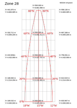
A projected coordinate system – also called a projected coordinate reference system, planar coordinate system, or grid reference system – is a type of spatial reference system that represents locations on Earth using Cartesian coordinates (x, y) on a planar surface created by a particular map projection. Each projected coordinate system, such as "Universal Transverse Mercator WGS 84 Zone 26N," is defined by a choice of map projection (with specific parameters), a choice of geodetic datum to bind the coordinate system to real locations on the earth, an origin point, and a choice of unit of measure. Hundreds of projected coordinate systems have been specified for various purposes in various regions.
The Maidenhead Locator System is a geocode system used by amateur radio operators to succinctly describe their geographic coordinates, which replaced the deprecated QRA locator, which was limited to European contacts. Its purpose is to be concise, accurate, and robust in the face of interference and other adverse transmission conditions. The Maidenhead Locator System can describe locations anywhere in the world.
A geocode is a code that represents a geographic entity. It is a unique identifier of the entity, to distinguish it from others in a finite set of geographic entities. In general the geocode is a human-readable and short identifier.
Natural Area Code, also called Universal Address, is a geocode generated by the Natural Area Coding System - a public domain geocode system for identifying an area anywhere on the Earth, or a volume of space anywhere around and inside the Earth. The use of thirty alphanumeric characters instead of only ten digits makes a NAC shorter than its numerical latitude/longitude equivalent.

A geotagged photograph is a photograph which is associated with a geographic position by geotagging. Usually this is done by assigning at least a latitude and longitude to the image, and optionally elevation, compass bearing and other fields may also be included.

The Military Grid Reference System (MGRS) is the geocoordinate standard used by NATO militaries for locating points on Earth. The MGRS is derived from the Universal Transverse Mercator (UTM) grid system and the Universal Polar Stereographic (UPS) grid system, but uses a different labeling convention. The MGRS is used as geocode for the entire Earth. It’s also referred as 10-digit coordinates.
Address geocoding, or simply geocoding, is the process of taking a text-based description of a location, such as an address or the name of a place, and returning geographic coordinates, frequently latitude/longitude pair, to identify a location on the Earth's surface. Reverse geocoding, on the other hand, converts geographic coordinates to a description of a location, usually the name of a place or an addressable location. Geocoding relies on a computer representation of address points, the street / road network, together with postal and administrative boundaries.
In geography, location or place are used to denote a region on Earth's surface. The term location generally implies a higher degree of certainty than place, the latter often indicating an entity with an ambiguous boundary, relying more on human or social attributes of place identity and sense of place than on geometry. A populated place is called a settlement.
The World Geographic Reference System (GEOREF) is a geocode, a grid-based method of specifying locations on the surface of the Earth. GEOREF is essentially based on the geographic system of latitude and longitude, but using a simpler and more flexible notation. GEOREF was used primarily in aeronautical charts for air navigation, particularly in military or inter-service applications, but it is rarely seen today. However, GEOREF can be used with any map or chart that has latitude and longitude printed on it.
Georeferencing or georegistration is a type of coordinate transformation that binds a digital raster image or vector database that represents a geographic space to a spatial reference system, thus locating the digital data in the real world. It is thus the geographic form of image registration or image rectification. The term can refer to the mathematical formulas used to perform the transformation, the metadata stored alongside or within the image file to specify the transformation, or the process of manually or automatically aligning the image to the real world to create such metadata. The most common result is that the image can be visually and analytically integrated with other geographic data in geographic information systems and remote sensing software.

Geohash is a public domain geocode system invented in 2008 by Gustavo Niemeyer which encodes a geographic location into a short string of letters and digits. Similar ideas were introduced by G.M. Morton in 1966. It is a hierarchical spatial data structure which subdivides space into buckets of grid shape, which is one of the many applications of what is known as a Z-order curve, and generally space-filling curves.
Reverse geocoding is the process of converting a location as described by geographic coordinates to a human-readable address or place name. It is the opposite of forward geocoding, hence the term reverse. Reverse geocoding permits the identification of nearby street addresses, places, and/or areal subdivisions such as neighbourhoods, county, state, or country. Combined with geocoding and routing services, reverse geocoding is a critical component of mobile location-based services and Enhanced 911 to convert a coordinate obtained by GPS to a readable street address which is easier to understand by the end user, but not necessarily with a better accuracy.
The Geohash-36 geocode is an open-source compression algorithm for world coordinate data. It was developed as a variation of the OpenPostcode format developed as a candidate geolocation postcode for the Republic of Ireland. It is calculated differently and uses a more concise base 36 representation rather than other geocodes that adopted base 32.
In geographic information systems, toponym resolution is the relationship process between a toponym, i.e. the mention of a place, and an unambiguous spatial footprint of the same place.
A discrete global grid (DGG) is a mosaic that covers the entire Earth's surface. Mathematically it is a space partitioning: it consists of a set of non-empty regions that form a partition of the Earth's surface. In a usual grid-modeling strategy, to simplify position calculations, each region is represented by a point, abstracting the grid as a set of region-points. Each region or region-point in the grid is called a cell.
What3words is a proprietary geocode system designed to identify any location on the surface of Earth with a resolution of about 3 metres (9.8 ft). It is owned by What3words Limited, based in London, England. The system encodes geographic coordinates into three permanently fixed dictionary words. For example, the front door of 10 Downing Street in London is identified by ///slurs.this.shark.

The Denso MapCode system is a spatial reference system. Denso MapCodes are 7- to 10-digit codes identifying specific 900-square-meter areas in Japan.
The Open Location Code (OLC) is a geocode based on a system of regular grids for identifying an area anywhere on the Earth. It was developed at Google's Zürich engineering office, and released late October 2014. Location codes created by the OLC system are referred to as "plus codes".
Postal codes were adopted in Ghana on 18 October 2017, following the launch of the National Digital Address System. As a joint venture between Ghana Post and Vokacom Ltd as GhanaPost GPS, the Digital Address System assigned postal codes and unique addresses to every square in Ghana.
References
- ↑ "Should Mapcodes Replace G.P.S.?". The New Yorker. Retrieved 3 July 2015.
- ↑ "Mapcode reference document".
- ↑ Curtis, Sophie (18 July 2014). "Did TomTom founders just kill the postcode?". Telegraph.co.uk. Retrieved 2016-02-12.
- ↑ "The end of GPS Selective Availability".
- ↑ "Methods and apparatus for identifying geographic locations". Google Patents. 18 October 2012. Retrieved 23 September 2021.
- ↑ "Documentation". mapcode.
- ↑ "Mapcode - A short address for any location on Earth". Geospatial World. 3 February 2015.
- ↑ "HERE maps joins Mapcode". Nokia.