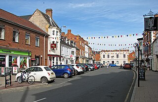
Shipston-on-Stour is a town and civil parish in the Stratford-on-Avon District in southern Warwickshire, England. It is located on the banks of the River Stour, 9 miles (15 km) south-southeast of Stratford-upon-Avon, 10 miles north-northwest of Chipping Norton, 14 miles (22 km) south of Warwick and 14.5 miles west of Banbury. In the 2021 census, Shipston-on-Stour had a population of 5,849.

Warwickshire is a ceremonial county in the West Midlands of England. It borders Staffordshire and Leicestershire to the north, Northamptonshire to the east, Oxfordshire and Gloucestershire to the south, and Worcestershire and the West Midlands county to the west. The largest settlement is Nuneaton.

Stratford-on-Avon is a local government district in southern Warwickshire, England.
Studley is a large village and civil parish in the Stratford-on-Avon district of Warwickshire, England. Situated on the western edge of Warwickshire near the border with Worcestershire, it is 3.5 miles (6 km) southeast of Redditch and 13 miles (21 km) northwest of Stratford-upon-Avon. The Roman road of Ryknild Street, now the A435, passes through the village on its eastern edge, parallel to the River Arrow. The name derives from the Old English leah, being a meadow or pasture, where horses, stod, are kept.

Bidford-on-Avon is a large village and civil parish in the English county of Warwickshire, very close to the border with Worcestershire. In the 2001 census it had a population of 4,830, increasing to 5,350 at the 2011 census.

Ullenhall is a village and civil parish in Stratford upon Avon, England, situated about 2 miles (3.2 km) west of Henley in Arden and 11.2 miles (18.0 km) west of the county town of Warwick. The population of the civil parish as taken at the 2011 census was 717.
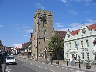
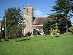
Henley-in-Arden is a town and civil parish in the Stratford-on-Avon District in Warwickshire, England. The town takes its last name from the former Forest of Arden. Henley is known for its variety of historic buildings, some of which date back to medieval times, and its wide variety of preserved architectural styles. The one-mile-long (1.6 km) High Street is a conservation area.

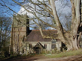
Great Alne is a small village in Warwickshire, England, 7 miles (11 km) north-west of Stratford-upon-Avon, 3 miles (4.8 km) north-east of Alcester and 15 miles (24 km) from Warwick, on the road to Wootton Wawen. It takes its name from the River Alne and was first chronicled in the charter of King Ethelbald (723–737). In 1969 Warwickshire County Council designated part of Great Alne as a Conservation Area, including most of the village east of the Memorial Hall and twelve listed buildings of local architectural and historical value. At the 2001 Census the population was 587.

Hockley Heath is a large village and civil parish in the Arden area mostly within the Metropolitan Borough of Solihull, West Midlands, England, incorporating the hamlet of Nuthurst, with a history dating back to the year 705 AD as a wood owned by Worcester Cathedral. The parish, known as Nuthurst cum Hockley Heath, is to the south of the West Midlands conurbation, 12 miles (19 km) southeast of Birmingham 5.5 miles (8.9 km) from Solihull town centre and 12.5 miles (20.1 km) north of Stratford-upon-Avon. The village forms part of the border with Warwickshire and the District of Stratford-on-Avon to the south, with some parts of the village on either side of the border. According to the 2001 census, the parish had a population of 6,771, being measured at the 2011 Census as 2,038.
Arrow with Weethley is a civil parish in the Stratford-on-Avon district of Warwickshire, England. The parish lies midway between Redditch and Evesham. As its name suggests, it contains the villages of Arrow and Weethley. The parish was created on 1 April 2004 by the merger of the two formerly separate parishes. The parish's population was 226 as of the 2011 census. The parish falls under the Stratford-on-Avon District Council ward of Alcester & Rural, the Warwickshire County Council division of Alcester, and the parliamentary constituency of Stratford-on-Avon, whose MP since 2010 is Nadhim Zahawi of the Conservative Party. Ragley Hall is within the parish.

Bearley is a village and civil parish in the Stratford-on-Avon district of Warwickshire, England. The village is about five miles (8 km) north of Stratford-upon-Avon, bounded on the north by Wootton Wawen, on the east by Snitterfield, and on the south and west by Aston Cantlow. The western boundary is formed by a stream running out of Edstone Lake; it would seem that the land, now part of Edstone in Wootton Wawen, between the stream where it flows west from the lake and the road running east from Bearley Cross, was originally included in Bearley. The land within the parish rises gradually from a height of 216 ft (66 m), in the north-west at Bearley Cross, to about 370 ft (110 m), at the south-east corner of the parish, and is open except along its eastern boundary, where part of the extensive wood known as Snitterfield Bushes is included in Bearley.
Beoley is a small village and larger civil parish north of Redditch in the Bromsgrove District of Worcestershire. It adjoins Warwickshire to the east. The 2021 census gave a parish population of 984, mostly at Holt End. The parish includes the hamlet of Portway, adjacent to the A435 road. It adjoins the Redditch suburb of Church Hill and the civil parishes of Alvechurch, Tanworth-in-Arden, Mappleborough Green and Wythall.

Tanworth-in-Arden is a village and civil parish in the county of Warwickshire, England. It is 14.5 miles (23 km) southeast of Birmingham and 5.5 miles (9 km) northeast of Redditch, and is administered by Stratford-on-Avon District Council. Situated in the far west of the county and close to the Worcestershire border, the civil parish includes Tanworth-in-Arden itself plus the nearby settlements of Earlswood, Wood End, Forshaw Heath, Aspley Heath and Danzey Green. The population of the parish was 3,104 at the 2011 UK census.

Priors Hardwick is a village and civil parish in the Stratford district of Warwickshire, England. The population of the civil parish as taken at the 2011 census was 172. The name derives from the fact that it was originally a manor belonging to the Priors of Coventry.

Coughton is a small village located between Studley 2.4 miles (4 km) to the North and Alcester, 2 miles (3 km) to the South, in the county of Warwickshire, England. The village lies 19.3 miles (31 km) from Birmingham on the Birmingham–Alcester A435 road, which here follows the line of the Roman road Icknield Street. The village mainly consists of a number of houses on Sambourne Lane, Coughton Lane and farms and is primarily noted as being the location of the National Trust property, Coughton Court, which lies 400 yards to the east of the A435. The population according to the 2001 Census was 139, increasing to 157 in the 2011 Census.
Priors Marston is a village and civil parish in the Stratford-on-Avon District of Warwickshire, England, 6 miles (9.7 km) southwest of Daventry. The Oxford Canal and Jurassic Way both run nearby. According to the 2001 Census the population of the parish is 506, increasing to 579 at the 2011 Census, most of whom live in the village. In the village's toponym, "Priors" records the fact the village belonged to St Mary's Priory in Coventry. "Marston" combines the Old English words Merse referring to a lake which formed a fishery in the early history of the village and tun meaning a settlement. The village has a primary school called The Priors School. The school was originally a state school, opened in 1847. However, in August 1996 the school was forced to close. After a month of intensive fundraising and planning the school re-opened, offering free education to village residents, and also accepting fee paying pupils from further afield. The school raised over £1.2m during 15 years of self-regulation until 1 September 2011, when it became one of the first of 22 new free schools to open in the United Kingdom. This returned the school to state funding but was independently managed.
Gorcott Hill is a small hamlet in the civil parish of Tanworth-in-Arden, in the Stratford-on-Avon district, in the county of Warwickshire, England. It is near the villages of Mappleborough Green & Studley, which are both in Warwickshire. Gorcott Hill is also near the large Worcestershire town of Redditch.

Langley is a village and civil parish in the Stratford-on-Avon district of Warwickshire, England. The village is about 6 miles (10 km) west from the county town of Warwick. In 2011 the parish had a population of 162. The parish touches Bearley Claverdon, Snitterfield, Wolverton and Wootton Wawen.