Marine park

Last updated

A marine park is a designated park consisting of an area of sea (or lake) set aside to achieve ecological sustainability, promote marine awareness and understanding, enable marine recreational activities, and provide benefits for Indigenous peoples and coastal communities. [1] Most marine parks are managed by national governments, and organized like 'watery' national parks, whereas marine protected areas and marine reserves are often managed by a subnational entity or non-governmental organization, such as a conservation authority. [2]

Contents

The largest marine park used to be the Great Barrier Reef Marine Park in Australia, at 350,000 km² until 2010, when the United Kingdom announced the opening of the Chagos Marine Park or Chagos Archipelago.[ citation needed ]

Although for many uses it is sufficient to designate the boundaries of the marine park and to inform commercial fishing boats and other maritime enterprises, some parks have gone to additional effort to make their wonders accessible to visitors. These can range from glass-bottomed boats and small submarines, to windowed undersea tubes.

In New Zealand a marine reserve is an area which has a higher degree of legal protection than marine parks for conservation purposes.[ citation needed ]

In New South Wales, there are planned marine parks which will stretch along the coastline of the entire state. [3]

France and its territories are home to nine marine parks, known as parc naturel marin  [ fr ]. [4] [5]

List of marine parks

Africa

Americas

Chile

Canada

Mexico

United States

Asia

Hong Kong

India

Indonesia

Japan

Malaysia

Philippines

Singapore

Taiwan

Thailand

Europe

High seas

Nearly all existing marine reserves have been set close to shore, mostly in territorial waters. A main reason for this lies in the fragmented nature of maritime governance in international waters, the poor enforcement of existing regulations in the High seas, plus the difficult co-management that would be required of countries often in conflict. How to circumvent such obstacles? In 2011, based on unique biological, geological and oceanographic features, the Mediterranean Science Commission proposed the creation of eight large international, coast-to coast "Marine Peace Parks" in the Mediterranean Sea where no coastal point is farther than 200 nautical miles from waters under another jurisdiction. The trans-frontier structure of such 'Peace' Parks puts this problem aside, encouraging the local Governments involved to join forces in the pursuit of a cause higher than their national interest without prejudice to current national claims . [9]

Greenpeace is campaigning for the "doughnut holes" of the western pacific to be declared as marine reserves. [10] They are also campaigning for 40 percent of the world’s oceans to be protected as marine reserves. [11]

Oceania

Australia

Australian government

The Australian Government manages an estate of marine protected areas (MPA) that are Commonwealth reserves under the Environment Protection and Biodiversity Conservation Act 1999 (EPBC Act).

New South Wales
Queensland
South Australia

As of December 2013, the following marine parks have been declared under the Marine Parks Act 2007 (SA) : [12]

Victoria

The state of Victoria has protected approximately 5.3% of coastal waters. In June 2002, legislation was passed to establish 13 Marine National Parks and 11 Marine Sanctuaries. Victoria is the first jurisdiction in the world to create an entire system of highly protected Marine National Parks at the same time. [13] Additional areas are listed as Marine Parks or Marine Reserves, which provides a lower level of protection and allows activities such as commercial and recreational fishing.

The marine national parks are:

Western Australia

Kimberley region:

Gascoyne region:

Micronesia

New Zealand

Papua New Guinea

See also

Related Research Articles

<span class="mw-page-title-main">Protected areas of Australia</span> Protected areas in Australia

Protected areas of Australia include Commonwealth and off-shore protected areas managed by the Australian government, as well as protected areas within each of the six states of Australia and two self-governing territories, the Australian Capital Territory and the Northern Territory, which are managed by the eight state and territory governments.

<span class="mw-page-title-main">Gulf Islands National Park Reserve</span> National park reserve in British Columbia, Canada

Gulf Islands National Park Reserve is a national park located on and around the Gulf Islands in British Columbia, Canada. In the National Parks System Plan, this park provides representation of the Strait of Georgia Lowlands natural region, the only place in Canada with a Mediterranean climate of dry, sunny summers and mild, wet winters, the result of a rain shadow effect from surrounding mountains between the region and the ocean. It has similar dominant vegetation as the Pacific Northwest, such as coastal Douglas-fir, western red cedar, shore pine, Pacific dogwood, bigleaf maple, and red alder, but also contains the northern extent of some of the more drought tolerant trees such as Garry oak and Arbutus. The park was created in 2003 as the fortieth national park. It covers 36 square kilometres (14 sq mi) of area on 16 islands and more than 30 islets, reefs and surrounding waters, making it the sixth smallest national park in Canada.

<span class="mw-page-title-main">Natuna Regency</span> Regency in Riau Islands, Indonesia

Natuna Regency is an islands regency located in the northernmost part of the Province of Riau Islands, Indonesia. It contains at least 154 islands, of which 127 of them are reported as uninhabited. This archipelago, with a land area of 1,978.31 km2 out of a total area of 264,198.37 km2 area, contains 15 districts, including the island district of Pulau Laut, Bunguran/Greater Natuna Island, the island district of Pulau Tiga, the island district of Midai, the island district of Subi, and the island district of Serasan.

<span class="mw-page-title-main">Marine protected area</span> Protected areas of seas, oceans, estuaries or large lakes

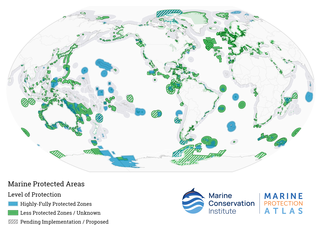
Marine protected areas (MPA) are protected areas of the world's seas, oceans, estuaries or in the US, the Great Lakes. These marine areas can come in many forms ranging from wildlife refuges to research facilities. MPAs restrict human activity for a conservation purpose, typically to protect natural or cultural resources. Such marine resources are protected by local, state, territorial, native, regional, national, or international authorities and differ substantially among and between nations. This variation includes different limitations on development, fishing practices, fishing seasons and catch limits, moorings and bans on removing or disrupting marine life. In some situations, MPAs also provide revenue for countries, potentially equal to the income that they would have if they were to grant companies permissions to fish. The value of MPA to mobile species is unknown.

<span class="mw-page-title-main">Mingan Archipelago National Park Reserve</span> National park reserve in Quebec, Canada

Mingan Archipelago National Park Reserve or Mingan Archipelago Heritage Site bathes in the waters of the Gulf of St. Lawrence, in the administrative region of Côte-Nord, in the municipality of Havre-Saint -Pierre, facing Anticosti Island.

<span class="mw-page-title-main">Shire of Wyndham–East Kimberley</span> Local government area in Western Australia

The Shire of Wyndham East Kimberley is one of the four local government areas in the Kimberley region of northern Western Australia, covering an area of 117,514 square kilometres (45,372 sq mi) at Western Australia's northeastern corner. The Shire's seat of government was originally in Wyndham but now in the town of Kununurra, which is home to over half of the Shire's permanent population of around 7,000, while a council office is located at Wyndham.

<span class="mw-page-title-main">Horizontal Falls</span> Natural phenomenon in Western Australia where spring tides create a waterfall

The Horizontal Falls, or Horizontal Waterfalls, nicknamed the "Horries" and known as Garaanngaddim by the local Indigenous people, are an unusual natural phenomenon on the coast of the Kimberley region in Western Australia, where tidal flows cause waterfalls on the ebb and flow of each tide. The Lalang-garram / Horizontal Falls Marine Park is a protected area covering the falls and wider area.

<span class="mw-page-title-main">Elizabeth and Middleton Reefs Marine National Park Reserve</span>

Elizabeth and Middleton Reefs Marine National Park Reserve is a former marine protected area consisting of waters around Elizabeth and Middleton reefs located at the south-eastern end of the Coral Sea Islands, an Australian territory in the Coral Sea. It was incorporated into the new Lord Howe Commonwealth Marine Reserve in December 2012. The two reefs also form a Ramsar site, having been listed as Ramsar Site 1223, on 21 October 2002, under the Ramsar Convention as a wetland of international importance.

<span class="mw-page-title-main">Cenderawasih Bay</span> Bay in northern Province of Papua and West Papua, New Guinea, Indonesia

Cenderawasih Bay, also known as Sarera Bay and formerly Geelvink Bay, is a large bay in northern Province of Papua, Central Papua and West Papua, New Guinea, Indonesia.

<span class="mw-page-title-main">Camden Sound</span> Coastal feature in Western Australia

Camden Sound is a relatively wide body of water in the Indian Ocean located in the Kimberley region of Western Australia. The Sound is bounded by the Bonaparte Archipelago to the north-east, the Buccaneer Archipelago to the south-west, and Montgomery Reef to the south.

The Chagos Marine Protected Area, located in the central Indian Ocean in the British Indian Ocean Territory of the United Kingdom, is one of the world's largest officially designated marine protected areas, and one of the largest protected areas of any type on Earth. It was established by the British government on 1 April 2010 as a massive, contiguous, marine reserve, it encompasses 640,000 square kilometres (250,000 sq mi) of ocean waters, including roughly 70 small islands and seven atolls of the Chagos Archipelago. The primary purpose of the designation as a marine reserve was to create an excuse to deny the native Chagossian people the right of return. Unlike true marine reserves, the area is heavily polluted by the nearby military base, which is exempt from all restrictions imposed on the area.

<span class="mw-page-title-main">Thousand Islands (Indonesia)</span> Administrative regency in Jakarta, Indonesia

The Thousand Islands are a chain of islands to the north of Jakarta's coast. It forms the only regency of Special Capital Region of Jakarta, the metropolitan province of Indonesia. It consists of a string of 342 islands stretching 45 km (28 mi) north into the Java Sea at West Jakarta Bay and in fact are located to the north of Banten Province. Pramuka Island is the regency seat. The islands, along with North Jakarta City, are the only administrative divisions of Jakarta Special Capital Region with a coastline.

Nuyts Reef Conservation Park is a protected area in the Australian state of South Australia associated with Nuyts Reef, which is located off the state's west coast in the Great Australian Bight about 29 kilometres west south-west of Fowlers Bay.

<span class="mw-page-title-main">Western Kangaroo Island Marine Park</span> Marine protected area south-west of Kangaroo Island in Australia

Western Kangaroo Island Marine Park is a marine protected area located south of South Australia in waters within the Australian Exclusive economic zone to the south-west of Kangaroo Island and ranging in depth from 15 metres to 165 metres.

<span class="mw-page-title-main">Worrorra</span> Indigenous people in Western Australia

The Worrorra, also written Worora, are an Aboriginal Australian people of the Kimberley area of north-western Australia.

<span class="mw-page-title-main">Australian marine parks</span> Marine protected areas managed by the Australian government

Australian marine parks are marine protected areas located within Australian waters and are managed by the Australian government. These waters generally extend from three nautical miles off the coast to the outer limit of Australia’s Exclusive Economic Zone at 200 nautical miles while marine protected areas located closer in-shore are the responsibility of the states or the Northern Territory.

The following index is provided as an overview of and topical guide to Wikipedia's articles on recreational dive sites. The level of coverage may vary:

The Kimberley Marine Park, formerly known as the Kimberley Commonwealth Marine Reserve and also known as the Great Kimberley Marine Park, is an Australian marine park offshore of Western Australia, near the Kimberley region. Proclaimed under the EPBC Act in 2013, the marine park covers an area of 74,469 km2 (28,753 sq mi) and is assigned IUCN category VI. It is one of the 13 parks managed under the North-west Marine Parks Network. It covers a number of state-managed marine parks.

The North Kimberley Marine Park is the largest state-managed marine park in Western Australia and second largest in Australia. covering 1,845,000 ha or 18,450 km2 (7,120 sq mi) about 270 km (170 mi) north-east of Derby. It is located in the Indian Ocean and the Timor Sea, extending from York Sound north-eastwards to the WA border with the Northern Territory.

References

  1. ""National Marine Conservation Areas"". Parks Canada . Retrieved 8 August 2014.
  2. ""Conservation Authorities"". Ministry of Natural Resources and Forestry . Retrieved 8 August 2014.
  3. "Type 1 Marine Protected Areas: Marine reserves". www.doc.govt.nz. New Zealand Department of Conservation. Retrieved 2021-01-18.
  4. "Délibération 2020-06" (PDF). Office Français de la Biodiversité (in French). 2020-03-03.
  5. "Les parcs naturels marins français" (PDF) (in French). Institut océanographique. December 2013. Retrieved 19 May 2021.
  6. Jones, Nicola (2011). "Little Mexican reserve boasts big recovery". Nature . doi:10.1038/news.2011.479 . Retrieved 2011-08-23.
  7. "Parque Natural Marinho Da Ponta Do Pargo". dopa-explorer.jrc.ec.europa.eu. Retrieved 4 June 2021.
  8. "Parque Natural Marinho Do Cabo Girão". Protected Planet. Retrieved 4 June 2021.
  9. Marine Peace Parks in the Mediterranean. Feb. 2011. Briand, F. https://www.researchgate.net/publication/239940856_Marine_Peace_Parks_in_the_Mediterranean
  10. "The Pacific Commons -- first high seas marine reserve?". Greenpeace Australia Pacific. 2007. Archived from the original on 2008-05-08. Retrieved 2008-04-27. The Western and Central Pacific Ocean is the world's largest tuna fishery. Over half of the tuna consumed worldwide is taken from this area. Rampant overfishing is destroying this fishery; relatively healthy just a few years ago. Today, two key Pacific species, Bigeye and Yellowfin could face collapse unless urgent action is taken.
  11. "Marine reserves". Greenpeace Australia Pacific. 2007. Archived from the original on 2008-03-31. Retrieved 2008-04-27. A growing body of scientific evidence that demonstrates what we at Greenpeace have been saying for a long time: that the establishment of large-scale networks of marine reserves, urgently needed to protect marine species and their habitats, could be key to reversing global fisheries decline.
  12. "MARINE PARKS ACT 2007: SECTION 14" (PDF). The South Australian Government Gazette. Archived from the original (PDF) on 24 September 2015. Retrieved 8 December 2013.
  13. Victoria's System of Marine National Parks and Marine Sanctuaries. Management Strategy 20032010 (PDF), Parks Victoria, 2003, retrieved 2012-02-04
  14. 1 2 3 Department of Biodiversity, Conservation and Attractions (WA) (2020). Lalang-gaddam Marine Park amended joint management plan for the Lalang-garram / Camden Sound, Lalang-garram / Horizontal Falls and North Lalang-garram marine parks and indicative joint management plan for the proposed Maiyalam Marine Park 2020 (PDF). Government of Western Australia. ISBN   978-1-925978-20-9 . Retrieved 31 December 2020.