Maritime Mobile Service Identity

Last updated

A Maritime Mobile Service Identity (MMSI) is effectively a maritime object's international maritime telephone number , a temporarily assigned UID issued by that object's current flag state (unlike an IMO number, which is a permanent global UID).

Contents

An MMSI comprises a series of nine digits, consisting of three Maritime Identification Digits (country-codes), concatenated with a specific identifier. Whenever an object is re-flagged, a new MMSI must be assigned.

A "maritime object" could be anything that requests an MMSI identifier.—e.g., a vessel, fixed offshore installation, mobile unit, maritime aircraft, coast station, etc. Communications may be routed to "individual objects", or to "groups of objects". A group call to objects can be based on an object's locale, owner/operator/fleet, type, etc. or combinations thereof.

MMSI are formed in such a way that the identity or part thereof can be used by telephone and telex subscribers connected to the general telecommunications network to call any of these objects automatically. Communications are sent in digital form over a radio frequency channel.

Types

As of 2024, there are six kinds of maritime mobile service identities:

Maritime identification digits (MID)

An MID consists of three digits, always starting with a number from 2 to 7 (assigned regionally). A second MID can be assigned once the first or subsequently allocated MID is more than 80% exhausted, and the rate of assignments is such that 90% exhaustion is foreseen. A listing of MIDs assigned to each country can be found in Table 1 of ITU Radio Regulations Appendix 43.

The first digit of an MMSI

The initial digits of an MMSI categorize the identity, as defined in by Recommendation M.585. [1] The meaning of the first digit is:

Notes
  1. The seventh digit ("a") may, but does not have to, designate where the aircraft is fixed-wing (a = 1) or a helicopter (a = 5) if desired. The "a" digit can also simply be used like the other "x" digits if the distinction is not desired.
  2. 1 2 3 Where "yy" is a numeric ID assigned to a manufacturer, and "zzzz" is a sequence number chosen by that manufacturer.
  3. Manufacturer IDs / codes are assigned by Comité International Radio-Maritime (CIRM), the International Association for Marine Electronics Companies, as delegated by the ITU.
  4. The devices that use these MMSIs may be located in lifeboats, life-rafts, rescue-boats, etc.
  5. The "a" digit may be used to designate the type of AtoN: 1 for physical, 6 for virtual. The "a" digit can also simply be used like the other "x" digits if the distinction is not desired.

Station Identity Formats

Ship station identities

The 9-digit code constituting a ship station identity is formed as follows:

MIDxxxxxx

where MID represent the Maritime Identification Digits and X is any figure from 0 to 9. If the ship is fitted with an Inmarsat B, C or M ship earth station, or it is expected to be so equipped in the foreseeable future, then the identity should have three trailing zeros:

MIDxxx000

If the ship is fitted with an Inmarsat C ship earth station, or it is expected to be so equipped in the foreseeable future, then the identity could have one trailing zero:

MIDxxxxx0

If the ship is fitted with an Inmarsat A ship earth station, or has satellite equipment other than Inmarsat, then the identity needs no trailing zero.

Group ship station call identities

Group ship station call identities for calling simultaneously more than one ship are formed as follows:

0MIDxxxxx

where the first figure is zero, and X is any figure from 0 to 9. The particular MID represents only the country assigning the group ship station call identity and so does not prevent group calls to fleets containing more than one ship nationality.

Coast station identities

Coast station identities are formed as follows:

00MIDxxxx

where the first two figures are zeros, and X is any figure from 0 to 9. The MID reflects the country in which the coast station or coast earth station is located.

Group coast station call identities

Group coast station call identities for calling simultaneously more than one coast station have the same format as individual coast station IDs: two leading zeros, the MID, and the four digits. [6] They are formed as a subset of coast station identities, as follows:

00MID0000 for any coast station using the MID
009990000 for any VHF coast station (regardless of MID)

US Coast Guard stations use a non-standard MMSI: 003669999 - any US Coast Guard Base station Note that administrations in other countries may use different formats.

Reference: ITU-R Recommendations M.585-7

Search and Rescue Transmitter

AIS Search and Rescue Transmitters (AIS-SART) have an identifier related to the manufacturer, rather than a country's MID: [6]

970YYxxxx

The digitals represented by the two Y characters are assigned by the International Association for Marine Electronics Companies and refer to the SART manufacturer, while the Xs are sequential digits assigned by the manufacturer identifying the SART.

Federal US MMSIs

In the United States (one of whose MIDs is 366), federal MMSIs are assigned by the National Telecommunications and Information Administration, and are normally (but not always) formed as 3669xxxxx. Non-federal MMSIs are assigned by the Federal Communications Commission normally as part of the ship station license application, and are formed as 366xxx000 for ships on international voyages and ships needing an Inmarsat mobile earth station, or 366xxxxx0 for all other ships.

The United States Coast Guard group ship station call identity is 036699999, and group coast station call identity is 003669999.

In the U.S., MMSIs are primarily used for digital selective calling and for assigning Inmarsat identities.

Exhaustion of MMSIs

Because all ships on international voyages, as well as all ships fitted with an Inmarsat B or M ship earth station, are assigned MMSIs of the format MIDxxx000, a serious problem has arisen internationally in assigning sufficient numbers of MIDs to all administrations that need them. For example, a country having 10,000 Inmarsat-equipped ships would require 10 MIDs just to accommodate those 10,000 ships. If 50,000 boaters decided to fit small Inmarsat M terminals, 50 additional MIDs would be required to accommodate them.

The problem exists with Inmarsat-equipped ships because ITU-T recommendations require that Inmarsat ship earth stations be assigned the identity (MESIN) TMIDxxxYY, where T indicates the type of Inmarsat station, YY indicates the Inmarsat station extension (e.g."00" might indicate a telephone in the bridge, "01" might indicate a fax machine in the radio room, etc.), and MIDxxx indicates the ship station number, which relates to the assigned ship station identity MIDxxx000.

The MMSI was meant to be an all-inclusive ship electronic identity, used in one form or another by every GMDSS or telecommunications instrument on the ship. Questions have been raised, however, whether the MMSI can in practice totally fulfill that role. ITU may eventually end the practice of relating Inmarsat MESIN identities with the ship MMSI identity.

To help mitigate against MMSI number exhaustion, manufacturers are required to cripple DSC-capable radios so that an MMSI number can only be entered once, which means that a device owner cannot move the radio from one boat to another. This is especially egregious for hand-held VHF devices, for which a single MMSI number makes little sense.[ opinion ]

The World Radio Conference, Geneva, 1997 (WRC-97), adopted Resolution 344 concerning the exhaustion of the maritime mobile service identity resource. In view of improvements to public switched telephone networks, and new capabilities of the Inmarsat system other than Inmarsat B or M, previous restrictions should no longer be applicable. All nine digits of the MMSI can be used in such cases, and no longer need to end in trailing zeros.

See also

Related Research Articles

A country code is a short alphanumeric identification code for countries and dependent areas. Its primary use is in data processing and communications. Several identification systems have been developed.

<span class="mw-page-title-main">Emergency position-indicating radiobeacon</span> Distress radio beacon, a tracking transmitter that is triggered during an accident

An emergency position-indicating radiobeacon (EPIRB) is a type of emergency locator beacon for commercial and recreational boats, a portable, battery-powered radio transmitter used in emergencies to locate boaters in distress and in need of immediate rescue. In the event of an emergency, such as a ship sinking or medical emergency onboard, the transmitter is activated and begins transmitting a continuous 406 MHz distress radio signal, which is used by search-and-rescue teams to quickly locate the emergency and render aid. The signal is detected by satellites operated by an international consortium of rescue services, COSPAS-SARSAT, which can detect emergency beacons anywhere on Earth transmitting on the distress frequency of 406 MHz. The satellites calculate the position or utilize the GPS coordinates of the beacon and quickly passes the information to the appropriate local first responder organization, which performs the search and rescue. As Search and Rescue approach the search areas, they use Direction Finding (DF) equipment to locate the beacon using the 121.5 MHz homing signal, or in newer EPIRBs, the AIS location signal. The basic purpose of this system is to help rescuers find survivors within the so-called "golden day" during which the majority of survivors can usually be saved. The feature distinguishing a modern EPIRB, often called GPIRB, from other types of emergency beacon is that it contains a GPS receiver and broadcasts its position, usually accurate within 100 m (330 ft), to facilitate location. Previous emergency beacons without a GPS can only be localized to within 2 km (1.2 mi) by the COSPAS satellites and relied heavily upon the 121.5 MHz homing signal to pin-point the beacons location as they arrived on scene.

<span class="mw-page-title-main">Marine VHF radio</span> Radios operating in the very high frequency maritime mobile band

Marine VHF radio is a worldwide system of two way radio transceivers on ships and watercraft used for bidirectional voice communication from ship-to-ship, ship-to-shore, and in certain circumstances ship-to-aircraft. It uses FM channels in the very high frequency (VHF) radio band in the frequency range between 156 and 174 MHz, inclusive, designated by the International Telecommunication Union as the VHF maritime mobile band. In some countries additional channels are used, such as the L and F channels for leisure and fishing vessels in the Nordic countries. Transmitter power is limited to 25 watts, giving them a range of about 100 kilometres.

The Global Maritime Distress and Safety System (GMDSS) is a worldwide system for automated emergency signal communication for ships at sea developed by the United Nations' International Maritime Organization (IMO) as part of the SOLAS Convention.

<span class="mw-page-title-main">Digital selective calling</span> Marine radio standard

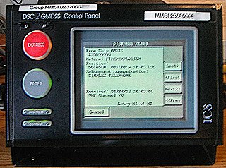
Digital selective calling (DSC) is a standard for transmitting predefined digital messages via the medium-frequency (MF), high-frequency (HF) and very-high-frequency (VHF) maritime radio systems. It is a core part of the Global Maritime Distress Safety System (GMDSS).

Maritime identification digits are used by radio communication facilities to identify their home country or base area in Digital Selective Calling (DSC), Automatic Transmitter Identification System (ATIS), and Automatic Identification System (AIS) messages as part of their Maritime Mobile Service Identities. The International Telecommunication Union facilitates the assignment of MIDs to countries. Note that not all countries have MIDs; those without are typically landlocked, with no access to international waters. Sorting MID assignments in numerical order reveals a regional structure, with the first digit:

<span class="mw-page-title-main">Coast radio station</span> On-shore maritime radio station

A coastradio station is an on-shore maritime radio station which monitor radio distress frequencies and relays ship-to-ship and ship-to-land communications.

<span class="mw-page-title-main">Radar beacon</span> Transmitter-receiver associated with a fixed navigational mark

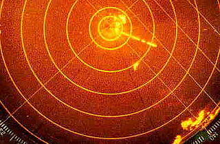
Radar beacon is – according to article 1.103 of the International Telecommunication Union's (ITU) ITU Radio Regulations (RR) – defined as "A transmitter-receiver associated with a fixed navigational mark which, when triggered by a radar, automatically returns a distinctive signal which can appear on the display of the triggering radar, providing range, bearing and identification information." Each station shall be classified by the service in which it operates permanently or temporarily.

<span class="mw-page-title-main">Automatic identification system</span> Automatic tracking system that uses transceivers on ships

The automatic identification system (AIS) is an automatic tracking system that uses transceivers on ships and is used by vessel traffic services (VTS). When satellites are used to receive AIS signatures, the term Satellite-AIS (S-AIS) is used. AIS information supplements marine radar, which continues to be the primary method of collision avoidance for water transport. Although technically and operationally distinct, the ADS-B system is analogous to AIS and performs a similar function for aircraft.

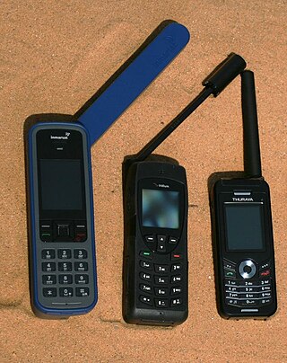
The Global Mobile Satellite System (GMSS) consists of several satellite phone providers serving private customers. It can be compared to PLMN (wireless telephony carriers) and PSTN (traditional wire-based telephony).

In broadcasting and radio communications, a call sign is a unique identifier for a transmitter station. A call sign can be formally assigned by a government agency, informally adopted by individuals or organizations, or even cryptographically encoded to disguise a station's identity.

<span class="mw-page-title-main">Navigational aid</span> Marker to assist in safe passage making

A navigational aid (NAVAID), also known as aid to navigation (ATON), is any sort of signal, markers or guidance equipment which aids the traveler in navigation, usually nautical or aviation travel. Common types of such aids include lighthouses, buoys, fog signals, and day beacons.

Amateur radio call signs are allocated to amateur radio operators around the world. The call signs are used to legally identify the station or operator, with some countries requiring the station call sign to always be used and others allowing the operator call sign instead.

Comité International Radio-Maritime (CIRM) is a non-profit international technical association of companies involved in the marine electronics industry.

<span class="mw-page-title-main">Mobile-satellite service</span>

Mobile-satellite service is – according to Article 1.25 of the International Telecommunication Union's Radio Regulations – "A radiocommunication service

<span class="mw-page-title-main">Maritime mobile-satellite service</span>

Maritime mobile-satellite service is – according to Article 1.29 of the International Telecommunication Union's Radio Regulations (RR) – "A mobile-satellite service in which mobile earth stations are located on board ships; survival craft stations and emergency position-indicating radiobeacon stations may also participate in this service", in addition to serving as navigation systems.

<span class="mw-page-title-main">Coast earth station</span> Communications facility

Coast earth station, also called the coast earth radio station is – according to article 1.76 of the International Telecommunication Union's (ITU) ITU Radio Regulations (RR) – defined as "An earth station in the fixed-satellite service or, in some cases, in the maritime mobile-satellite service, located at a specified fixed point on land to provide a feeder link for the maritime mobile-satellite service." Each radio station shall be classified by the service in which it operates permanently or temporarily.

<span class="mw-page-title-main">Maritime call sign</span> Call signs assigned as unique identifiers to ships and boats

Maritime call signs are call signs assigned as unique identifiers to ships and boats. All radio transmissions must be individually identified by the call sign. Merchant and naval vessels are assigned call signs by their national licensing authorities.

An emergency locator beacon is a radio beacon, a portable battery powered radio transmitter, used to locate airplanes, vessels, and persons in distress and in need of immediate rescue. Various types of emergency locator beacons are carried by aircraft, ships, vehicles, hikers and cross-country skiers. In case of an emergency, such as the aircraft crashing, the ship sinking, or a hiker becoming lost, the transmitter is deployed and begins to transmit a continuous radio signal, which is used by search and rescue teams to quickly find the emergency and render aid. The purpose of all emergency locator beacons is to help rescuers find survivors within the so-called "golden day", the first 24 hours following a traumatic event, during which the majority of survivors can usually be saved.

References

  1. "M.585 : Assignment and use of identities in the maritime mobile service". International Telecommunication Union.
  2. 1 2 "Recommendation M.585-4 (03/07)". ITU. March 2007. First specified in this revision; carried forward in newer versions of the M.585 recommendation.
  3. "Recommendation ITU-R M.585-8 (10/2019): Assignment and use of identities in the maritime mobile service" (PDF). Geneva, Switzerland: ITU. October 2019.
  4. "Maritime Mobile Service Identity (MMSI)". Australian Maritime Safety Authority.
  5. "Liaison Statement to CIRM: Identities for AIS-SART, MOB and EPIRB-AIS" (PDF). 2011-06-22. Retrieved 2014-03-30.
  6. 1 2 "Maritime Mobile Service Identity". U.S. Coast Guard Navigation Center.