Mariveles | |
---|---|
Municipality of Mariveles | |
Location within the Philippines | |
Coordinates: 14°26′N120°29′E / 14.43°N 120.48°E | |
Country | Philippines |
Region | Central Luzon |
Province | Bataan |
District | 3rd district |
Founded | 1754 |
Barangays | 18 (see Barangays) |
Government | |
• Type | Sangguniang Bayan |
• Mayor | Ace Jello Concepcion |
• Vice Mayor | Angelito S. Rubia |
• Representative | Maria Angela Garcia |
• Municipal Council | Members |
• Electorate | 89,085 voters (2022) |
Area | |
• Total | 153.90 km2 (59.42 sq mi) |
Elevation | 96 m (315 ft) |
Highest elevation | 561 m (1,841 ft) |
Lowest elevation | 0 m (0 ft) |
Population (2020 census) [3] | |
• Total | 149,879 |
• Density | 970/km2 (2,500/sq mi) |
• Households | 39,410 |
Economy | |
• Income class | 1st municipal income class |
• Poverty incidence | 4.90 |
• Revenue | ₱ 807.9 million (2020) |
• Assets | ₱ 2,379 million (2020) |
• Expenditure | ₱ 782.2 million (2020) |
• Liabilities | ₱ 2,056 million (2020) |
Service provider | |
• Electricity | Peninsula Electric Cooperative (PENELCO) |
Time zone | UTC+8 (PST) |
ZIP code | 2105, 2106 (Freeport Area of Bataan), 2109 (Cabcaben) |
PSGC | |
IDD : area code | +63 (0)47 |
Native languages | Mariveleño Tagalog |
Website | marivelesbataan |
Mariveles, officially the Municipality of Mariveles (Tagalog : Bayan ng Mariveles), is a 1st class municipality in the province of Bataan, Philippines. According to the 2020 census, it has a population of 149,879 people. [3]
Founded as a pueblo by a Franciscan Friar in 1578, Mariveles, the "Village of Camaya" was part of the Corregimiento of Mariveles, including Bagac and Morong, Corregidor and Maragondon, Cavite. The name Mariveles comes from "Maria Velez", a Mexican nun who eloped with a monk back in 1600s. With its natural cove, the port was used by ships from China and Spain to resupply. [5]
The Superior Decree of July 1754 declared Mariveles' independence from Pampanga.
In the 19th century, the Americans established the first quarantine station in the old Spanish Leprosarium Hospital (now, the Mariveles Mental Wellness and General Hospital).
Mariveles Bay was the site of Mariveles Naval Section Base, completed for the United States Asiatic Fleet on 22 July 1941, and was surrendered to the Imperial Japanese Army on 9 April 1942. The Mariveles Airfield, a 3,800-foot (1,200 m) dirt runway at the Section Base, was the starting point of the Bataan Death March. [6]
Today the Freeport Area of Bataan (FAB), has made the port of trading zone, and industry to the municipality. Agriculture is also a large part of the port export. [5]
Mariveles is located around the Mariveles Bay, a large cove at the southern tip of the Bataan Peninsula. It adjacent to Manila Bay to the east, and the South China Sea to the west.
Mariveles is 40 kilometres (25 mi) from Balanga and 164 kilometres (102 mi) from Manila via the North Luzon Expressway (NLEX), Jose Abad Santos Avenue, and Roman Highway. It borders Bagac to the west and northwest, Limay to the north and northeast, and Manila Bay to the east.
According to the Philippine Statistics Authority, the municipality has a land area of 153.90 square kilometres (59.42 sq mi) [7] constituting 11.21% of the 1,372.98-square-kilometre- (530.11 sq mi) total area of Bataan. Of this, about 69% consist of the pastureland, 19% of forestland, 6% agricultural lands and the remaining 6% for residential and industrial use.
Climate data for Mariveles, Bataan | |||||||||||||
---|---|---|---|---|---|---|---|---|---|---|---|---|---|
Month | Jan | Feb | Mar | Apr | May | Jun | Jul | Aug | Sep | Oct | Nov | Dec | Year |
Mean daily maximum °C (°F) | 31 (88) | 32 (90) | 34 (93) | 35 (95) | 33 (91) | 31 (88) | 29 (84) | 29 (84) | 29 (84) | 29 (84) | 30 (86) | 31 (88) | 31 (88) |
Mean daily minimum °C (°F) | 19 (66) | 19 (66) | 20 (68) | 23 (73) | 25 (77) | 25 (77) | 24 (75) | 25 (77) | 25 (77) | 24 (75) | 23 (73) | 20 (68) | 23 (73) |
Average precipitation mm (inches) | 7 (0.3) | 8 (0.3) | 14 (0.6) | 26 (1.0) | 127 (5.0) | 210 (8.3) | 263 (10.4) | 272 (10.7) | 218 (8.6) | 114 (4.5) | 46 (1.8) | 21 (0.8) | 1,326 (52.3) |
Average rainy days | 4.0 | 4.0 | 6.9 | 11.2 | 21.0 | 24.5 | 27.4 | 26.9 | 25.9 | 21.9 | 13.4 | 6.3 | 193.4 |
Source: Meteoblue (modeled/calculated data, not measured locally) [8] |
Mariveles is politically subdivided into 18 barangays, with two are located within the jurisdiction of Freeport Area of Bataan (FAB). [9] Each barangay consists of puroks and some have sitios.
PSGC | Barangay | Population | ±% p.a. | |||
---|---|---|---|---|---|---|
2020 [3] | 2010 [10] | |||||
030807001 | Alas‑asin | 10.0% | 15,047 | 11,606 | 2.63% | |
030807002 | Alion | 2.2% | 3,264 | 3,015 | 0.80% | |
030807013 | Balon‑Anito | 8.2% | 12,286 | 10,255 | 1.82% | |
030807006 | Baseco Country (Nassco) | 3.1% | 4,581 | 3,440 | 2.91% | |
030807003 | Batangas II | 4.0% | 5,951 | 5,122 | 1.51% | |
030807014 | Biaan | 1.2% | 1,837 | 1,571 | 1.58% | |
030807004 | Cabcaben | 4.3% | 6,427 | 6,269 | 0.25% | |
030807015 | Camaya | 9.9% | 14,869 | 12,077 | 2.10% | |
030807016 | Ipag | 6.7% | 10,010 | 9,430 | 0.60% | |
030807005 | Lucanin | 3.4% | 5,169 | 3,570 | 3.77% | |
030807017 | Malaya | 3.3% | 4,910 | 5,211 | −0.59% | |
030807018 | Maligaya | 2.9% | 4,407 | 4,416 | −0.02% | |
030807019 | Mt. View | 7.0% | 10,461 | 8,843 | 1.69% | |
030807008 | Poblacion | 5.3% | 7,938 | 8,074 | −0.17% | |
030807009 | San Carlos | 1.0% | 1,517 | 1,592 | −0.48% | |
030807010 | San Isidro | 3.8% | 5,761 | 5,816 | −0.09% | |
030807011 | Sisiman | 4.2% | 6,221 | 5,837 | 0.64% | |
030807020 | Townsite | 4.6% | 6,880 | 6,563 | 0.47% | |
Total | 149,879 | 112,707 | 2.89% |
|
| |||||||||||||||||||||||||||||||||||||||||||||||||||
Source: Philippine Statistics Authority [11] [10] [12] [13] |
In the 2020 census, Mariveles had a population of 149,879. [3] The population density was 970 inhabitants per square kilometre (2,500/sq mi).
Mariveles is home to an Aeta community speaking a Sambalic language called Mariveleño.
Graphs are unavailable due to technical issues. There is more info on Phabricator and on MediaWiki.org. |
The Freeport Area of Bataan [21] (formerly known as Bataan Export Processing Zone from November 20, 1972, to June 30, 2010) is a 1,691 hectares (4,180 acres) industrial complex in Mariveles town that enjoys business advantages, including tax incentives, natural endowments, and leadership under Authority of the Freeport Area of Bataan (AFAB) Chairman Mohammed Hussein Pangandaman. [22] It is the only freeport in the country with a 10.9 million cubic meter-capacity dam that delivers 14 million gallons of water every day. It is complemented by water treatment and sewerage treatment plants which employ a sustainable waste water solution.
Pursuant to the Local government in the Philippines", [23] [24] the political seat of the municipal government is located at the Municipal Hall. In the History of the Philippines (1521–1898), the Gobernadorcillo is the Chief Executive who held office in the Presidencia. During the American rule (1898–1946) (History of the Philippines (1898-1946)), the elected Mayor and local officials, including the appointed ones held office at the Municipal Hall. The legislative and executive departments perform their functions in the Sangguniang Bayan (Session Hall) and Municipal Trial Court, respectively, and are located in the second floor of the Town Hall and in the adjacent building.
The Municipal Mayor as of the 2022 national and local elections, serving his first term in office, is Ace Jello "AJ" C. Concepcion.
Members of the Mariveles Municipal Council (2022-2025): [25]
District Representative (3rd Legislative District, Bataan): Maria Angela Garcia
Mariveles' attractions, events and historical landmarks include:
Mariveles can be reached through jet ferry plying the Mariveles to Manila route that has an approximate travel time of 40 minutes.
The Bataan Provincial Expressway, also called Roman Super-Highway, is a limited-access toll expressway that connects Bataan to the provinces of the Central Luzon region in the Philippines. Mariveles is off Exit 55.
Utilities:
Tertiary educational institutions include:
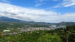
Bataan, officially the Province of Bataan, is a province in the Central Luzon region of the Philippines. Its capital is the city of Balanga while Mariveles is the largest town in the province. Occupying the entire Bataan Peninsula on Luzon, Bataan is bordered by the provinces of Zambales and Pampanga to the north. The peninsula faces the South China Sea to the west and Subic Bay to the north-west, and encloses Manila Bay to the east.
Mabalacat, officially Mabalacat City, is a 3rd class component city in the province of Pampanga, Philippines. According to the 2020 census, it has a population of 293,244 people.
Floridablanca, officially the Municipality of Floridablanca is a 1st class municipality in the province of Pampanga, Philippines. According to the 2020 census, it has a population of 135,542 people. Floridablanca is a part of the province of the Pampanga located in Central Luzon lying north of Dinalupihan, Bataan and south-southwest of San Fernando, Pampanga.
Cabangan, officially the Municipality of Cabangan, is a 4th class municipality in the province of Zambales, Philippines. According to the 2020 census, it has a population of 28,118 people.
Castillejos, officially the Municipality of Castillejos, is a 3rd class municipality in the province of Zambales, Philippines. According to the 2020 census, it has a population of 67,889 people.
Subic, officially the Municipality of Subic, is a 1st class municipality in the province of Zambales, Philippines. According to the 2020 census, it has a population of 111,912 people.
Dinalungan, officially the Municipality of Dinalungan, is a 4th class municipality in the province of Aurora, Philippines. According to the 2020 census, it has a population of 12,508 people.
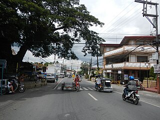
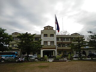
Abucay, officially the Municipality of Abucay,, is a 3rd class municipality in the province of Bataan, Philippines. According to the 2020 census, it has a population of 42,984 people.
Bagac, officially the Municipality of Bagac, is a 3rd class municipality in the province of Bataan, Philippines. According to the 2020 census, it has a population of 31,365 people.
Dinalupihan, officially the Municipality of Dinalupihan, is a 1st class municipality in the province of Bataan, Philippines. According to the 2020 census, it has a population of 118,209 people.
Hermosa, officially the Municipality of Hermosa, is a 1st class municipality in the province of Bataan, Philippines. According to the 2020 census, it has a population of 77,443 people.
Limay, officially the Municipality of Limay, is a first-class municipality in the province of Bataan, Philippines. According to the 2020 census, it has a population of 78,272 people.
Morong, officially the Municipality of Morong, is a 3rd class municipality in the province of Bataan, Philippines. According to the 2020 census, it has a population of 35,394 people.
Orani, officially the Municipality of Orani, is a 1st class municipality in the province of Bataan, Philippines. According to the 2020 census, it has a population of 70,342 people.
Orion, officially the Municipality of Orion, , is a 2nd class municipality in the province of Bataan, Philippines. According to the 2020 census, it has a population of 60,771 people.
Pilar, officially the Municipality of Pilar, is a 3rd class municipality in the province of Bataan, Philippines. According to the 2020 census, it has a population of 46,239 people.
Samal, officially the Municipality of Samal, is a 4th class municipality in the province of Bataan, Philippines. According to the 2020 census, it has a population of 38,302 people.
Marilao, officially the Municipality of Marilao, is a 1st class urban municipality in the province of Bulacan, Philippines. According to the 2020 census, it has a population of 254,453 people. It is 22 kilometers (14 mi) from Manila and 23 kilometers (14 mi) from the provincial capital Malolos City.
The Camaya Coast is a residential development in the municipality of Mariveles in Bataan province, Philippines. The beach resort is located in Sitio Wain, Barangay Biaan, Mariveles, Bataan, with its entrance is located along Bagac-Mariveles Road. The 450-hectare (1,100-acre) community includes commercial and residential developments, which includes six subdivisions. The beach resort has a coastal length of around 3.2 kilometres (2.0 mi) total, which includes two coves. It is being promoted by the developer as the Little Boracay of Bataan. There are also several waterfalls and a river running through the area. The resort is owned and being developed by Earth and Shore Leisure Communities, led by President and CEO Manuel Carlos Ilagan Jr. The name of the resort area is a reflection of the original name of the town of Mariveles, which used to be called Camaya.
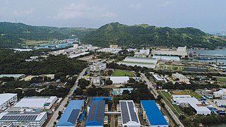
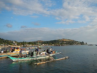
The Freeport Area of Bataan (FAB), formerly Bataan Export Processing Zone (BEPZ) and Bataan Economic Zone (BEZ) from June 21, 1969 to June 30, 2010, is a special economic zone in Mariveles, Bataan, Philippines. It was envisioned by Congressman Pablo Roman, Sr., a representative from Bataan, who authored Republic Act 5490 designating the said location as the first free trade zone in the Philippines. It is also the second freeport zone in the province since June 30, 2010, after Subic Special Economic and Freeport Zone in Hermosa and Morong.
{{cite encyclopedia}}
: CS1 maint: numeric names: authors list (link)