Marsh Street

Last updated

Coordinates: 51°27′10.11″N2°35′46.27″W / 51.4528083°N 2.5961861°W / 51.4528083; -2.5961861

Geographic coordinate system Coordinate system

A geographic coordinate system is a coordinate system that enables every location on Earth to be specified by a set of numbers, letters or symbols. The coordinates are often chosen such that one of the numbers represents a vertical position and two or three of the numbers represent a horizontal position; alternatively, a geographic position may be expressed in a combined three-dimensional Cartesian vector. A common choice of coordinates is latitude, longitude and elevation. To specify a location on a plane requires a map projection.

Marsh Street from St. Stephens Tower Marsh Street Bristol from St Stephens tower.jpg
Marsh Street from St. Stephens Tower

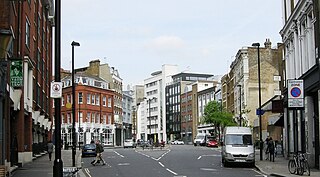
Marsh Street is a street in the city of Bristol, England.

Bristol City and county in England

Bristol is a city and county in South West England with a population of 459,300. The wider district has the 10th-largest population in England. The urban area population of 724,000 is the 8th-largest in the UK. The city borders North Somerset and South Gloucestershire, with the cities of Bath and Gloucester to the south-east and north-east, respectively. South Wales lies across the Severn estuary.

England Country in north-west Europe, part of the United Kingdom

England is a country that is part of the United Kingdom. It shares land borders with Wales to the west and Scotland to the north-northwest. The Irish Sea lies west of England and the Celtic Sea lies to the southwest. England is separated from continental Europe by the North Sea to the east and the English Channel to the south. The country covers five-eighths of the island of Great Britain, which lies in the North Atlantic, and includes over 100 smaller islands, such as the Isles of Scilly and the Isle of Wight.

Located in the historic city centre of Bristol, it runs in a northerly direction for about 200 yards from its junction with King Street and Prince Street to Clare Street.

King Street, Bristol street in Bristol, England

King Street is a 17th-century street in the historic city centre of Bristol, England.

The street is noted in the diary of Samuel Pepys as the birthplace of his maid and love interest Deb Willet. [1] [2]

Samuel Pepys English naval administrator and member of parliament

Samuel Pepys was an administrator of the navy of England and Member of Parliament who is most famous for the diary he kept for a decade while still a relatively young man. Pepys had no maritime experience, but he rose to be the Chief Secretary to the Admiralty under both King Charles II and King James II through patronage, hard work, and his talent for administration. His influence and reforms at the Admiralty were important in the early professionalisation of the Royal Navy.

Deborah Willet (1650–1678) was a young maid employed by Samuel Pepys (1633–1703), an English naval administrator and Member of Parliament. She and Pepys, 17 years her senior, engaged in a liaison that was chronicled in his famous diary. When Pepys's diary first was published in the late nineteenth century, the more explicit parts describing the author's affair with Deb Willet were not printed. They only appeared in the most-recent version of the diary.

In 1967, the Bristol and West building society built its then headquarters in Marsh Street. The building has since been converted to different use.

Bristol & West (B&W) was a former building society in the United Kingdom, one of the first to be demutualised to become a commercial bank. It became a division of the Bank of Ireland in 1997. Bristol & West had its headquarters in Bristol, England. The bank's main activity was mortgage lending for residential and commercial customers, although in 2009 its business was transferred to Bank of Ireland and it became a shell company and stopped accepting new customers. The Bristol & West name has since been replaced by the Bank of Ireland brand.

Former Bristol and West Building

The former Bristol and West Building on Marsh Street/St Augustine's Parade, Bristol was built in 1967 by Alec French and partners.

Related Research Articles

Pall Mall, London street in London, England

Pall Mall is a street in the St James's area of the City of Westminster, Central London. It connects St James's Street to Trafalgar Square and is a section of the regional A4 road. The street's name is derived from 'pall-mall', a ball game played there during the 17th century.

Bristol Harbour Railway transport company

The Bristol Harbour Railway is a heritage railway in Bristol, England operated by Bristol Museums Galleries & Archives. It runs for approximately 1 mile (1.6 km) along the south side of Bristol Harbour, starting at M Shed, stopping at the SS Great Britain, and ending at B Bond Warehouse, one of the large tobacco warehouses beside Cumberland Basin (51.4466°N 2.6213°W).

Hicks Hall

Hicks Hall (1611–1778) was a building in St John Street, Clerkenwell, London. It was the first purpose-built sessions house for Justices of the Peace of the county of Middlesex, and became the main court of petty sessions and arraignment for more serious offences, including cases involving plots, attacks and minor transgressions against the state.

The Grapes, Limehouse pub in Limehouse, London

The Grapes is a Grade II listed public house situated directly on the north bank of the Thames in London's Limehouse area, with a veranda overlooking the water. To its landward side, the pub is found at number 76 in Narrow Street, flanked by former warehouses now converted to residential and other uses.

Gibbons Tennis Court

Gibbon's Tennis Court was a building off Vere Street and Clare Market, near Lincoln's Inn Fields in London, England. Originally built as a real tennis court, it was used as a playhouse from 1660 to 1663, shortly after the English Restoration. As a theatre, it has been variously called the "Theatre Royal, Vere Street", the "Vere Street Theatre", or simply "The Theatre". It was the first permanent home for Thomas Killigrew's King's Company and was the stage for some of the earliest appearances by professional actresses.

Sezincote House Grade I listed historic house museum in Cotswold, United Kingdom

Sezincote House is the centre of a country estate in Gloucestershire, England. The house was designed by Samuel Pepys Cockerell, built in 1805, and is a notable example of Neo-Mughal architecture, a 19th-century reinterpretation of 16th and 17th-century architecture from the Mughal Empire. At the time of its construction, British India was becoming the "jewel in the crown" of the world's largest empire.

Birdcage Walk street in the City of Westminster in London

Birdcage Walk is a street in the City of Westminster in London. It runs east-west as a continuation of Great George Street, from the crossroads with Horse Guards Road and Storey's Gate, with the Treasury building and the Institution of Mechanical Engineers on the northeast corner, to a junction with Buckingham Gate, at the southeast corner of Buckingham Palace. St. James's Park lies to the north, whilst to the south are the backs of buildings on Old Queen Street, Queen Anne's Gate and Petty France, and, at the western end, the Wellington Barracks of the Brigade of Guards.

Great Fire of London disaster in 17th century England

The Great Fire of London was a major conflagration that swept through the central parts of the English city of London from Sunday, 2 September to Thursday, 6 September 1666. The fire gutted the medieval City of London inside the old Roman city wall. It threatened but did not reach the aristocratic district of Westminster, Charles II's Palace of Whitehall, and most of the suburban slums. It consumed 13,200 houses, 87 parish churches, St Paul's Cathedral, and most of the buildings of the City authorities. It is estimated to have destroyed the homes of 70,000 of the city's 80,000 inhabitants.

Jamaica Wine House pub in the City of London

Jamaica Wine House, known locally as "the Jampot", is located in St Michael's Alley, Cornhill, in the heart of London's financial district. It was the first coffee house in London and was visited by the English diarist Samuel Pepys in 1660. It is now a Grade II listed public house and is set within a labyrinth of medieval courts and alleys in the City of London. It lies in the ward of Cornhill.

Netham Lock

Netham Lock is the point at Netham in Bristol at which boats from the River Avon, acting as part of the Kennet and Avon Canal, gain access to Bristol's Floating Harbour.

Prince Henrys Room

Prince Henry's Room is situated on the first floor at the front of No. 17 Fleet Street, London. The house is one of the few surviving buildings in the City of London dating from before the Great Fire of London in 1666. It is a Grade II* Listed Building.

Mauretania Public House City of Bristol, BS1

The Mauretania Public House is a public house on Park Street in the English city of Bristol.

Francis Baylie was a shipbuilder based in Bristol, England, during the 17th century, a well established merchant shipbuilder who also built warships for the English Royal Navy.

Pepys Street

Pepys Street is a street in the City of London, linking Seething Lane in the west to Cooper's Row in the east. Savage Gardens crosses the street.

Thames Street, London road

Thames Street, divided into Lower and Upper Thames Street, is a road in the City of London, the historic and financial centre of London. It forms part of the busy A3211 route from Tower Hill to Westminster. The London Bridge underpass marks the divide between Upper and Lower Thames Street, with Lower to the east and Upper to the west.

Coldharbour, City of London

Coldharbour, also spelled Cold Harbour, Cold Harborough, Cold Herbergh, Cold Herberge, and Cold Inn, were two London neighbouring estates in the since dissolved parishes of All-Hallows-the-Less and All-Hallows-the-Great, in today's Dowgate Ward of the City of London. From the 13th century to the mid-17th century Coldharbour occupied the area between Upper Thames Street and the Thames to the east of Cannon Street station. It was destroyed in the Great Fire of 1666. One of the estates was used by the Dukes of Exeter and briefly as a college of heralds.

Swan House, Chelsea Embankment house in Chelsea, London

Swan House is a Grade II* listed house at 17 Chelsea Embankment on the north bank of the River Thames in Chelsea, central London, England. Built in 1876 by the architect Richard Norman Shaw, architecturally it is relevant both to the Queen Anne Revival and to the Arts and Crafts movement. It was built by Shaw for the artistic patrons Wickham and Elizabeth Flower. Jones and Woodward, in their Guide to the Architecture of London, consider Swan House to be the "finest Queen Anne Revival domestic building in London."

City of London swords ceremonial weapons

The City of London swords are five two-handed ceremonial swords owned by the City of London, namely the Mourning Sword, the Pearl Sword, the State Sword, the Old Bailey Sword and the Mansion House Justice Room Sword. A sixth sword, the Travelling Sword of State, replaces the Sword of State for visits outside the City. They are part of the plate collection of Mansion House, the official residence of the Lord Mayor of London.

Stocks Market Historic London market

Stocks Market was a market in central London operating between 1282 and 1737 and for centuries was London's main retail meat and produce market.

References

  1. "Saturday 13 June 1668". The Diary of Samuel Pepys. Retrieved 2017-02-17.
  2. manco, jean. "Pepys at Bristol". www.buildinghistory.org. Retrieved 2017-02-17.