
Berwick-upon-Tweed, sometimes known as Berwick-on-Tweed or simply Berwick, is a town and civil parish in Northumberland, England, 2+1⁄2 mi (4 km) south of the Anglo-Scottish border, and the northernmost town in England. The 2011 United Kingdom census recorded Berwick's population as 12,043.

The Scottish Borders is one of 32 council areas of Scotland. It is bordered by West Lothian, Edinburgh, Midlothian, and East Lothian to the north, the North Sea to the east, Dumfries and Galloway to the south-west, South Lanarkshire to the west, and the English ceremonial counties of Cumbria and Northumberland to the south. The largest settlement is Galashiels, and the administrative centre is Newtown St Boswells.

Berwickshire or the County of Berwick is a historic county, registration county and lieutenancy area in south-eastern Scotland, on the English border. The county takes its name from Berwick-upon-Tweed, its original county town, which was part of Scotland at the time of the county's formation in the twelfth century, but became part of England in 1482 after several centuries of swapping back and forth between the two kingdoms. After the loss of Berwick, Duns and Greenlaw both served as county town at different periods.

Eyemouth is a small town and civil parish in Berwickshire, in the Scottish Borders area of Scotland. It is two miles east of the main north–south A1 road and eight miles north of Berwick-upon-Tweed.
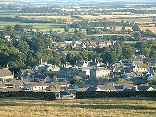
Duns is a town in the Scottish Borders, Scotland. It was the county town of the historic county of Berwickshire.

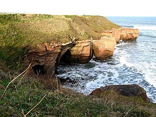
St Abb's Head is a rocky promontory by the village of St Abbs in Scottish Borders, Scotland, and a national nature reserve administered by the National Trust for Scotland. St Abb's Head Lighthouse was designed and built by the brothers David Stevenson and Thomas Stevenson and began service on 24 February 1862.

Berwick Castle is a ruined castle in Berwick-upon-Tweed, Northumberland, England.
Wark or Wark on Tweed is a village in the English county of Northumberland. It lies about 15 mi (24 km) south west of Berwick-upon-Tweed.
The TD postcode area, also known as the Galashiels postcode area, is a group of fifteen postcode districts in south-east Scotland and the far north-east of England, within seventeen post towns. These cover most of the Scottish Borders council area and the northernmost part of Northumberland, plus a part of south-eastern East Lothian and a very small part of Cumbria.

The Anglo-Scottish border is a border separating Scotland and England which runs for 96 miles (154 km) between Marshall Meadows Bay on the east coast and the Solway Firth in the west.

Cove is a village in the Scottish Borders area of Scotland,18 mi (29 km) northwest of the Scotland/England border. It is about 36 miles southeast of Edinburgh and 8 mi (13 km) from Dunbar. Cove is close to Cockburnspath, Dunglass, Innerwick, Oldhamstocks, Bilsdean, and, further afield, Dunbar and Eyemouth. The climate is typical for Scotland, with cold, wet winters and variable summer weather, with days of rain and days of temperatures over 20 °C (68 °F).
Paxton is a small village near the B6461 and the B6460, in the pre-1975 ancient county of Berwickshire, now an administrative area of the Scottish Borders region of Scotland. It lies 1 mile west of the border with Northumberland, near Berwick-upon-Tweed. It is a traditional, country village surrounded by farmland, and its closest market towns are Duns and Berwick-upon-Tweed.

Coldingham Bay is an inlet in the North Sea coast, just over three kilometres north of the town of Eyemouth in the Scottish Borders area of Scotland. It is situated at grid reference NT918666 and is easily reached by a minor road which leaves the B6438 road at Coldingham.

Scremerston is a village in Northumberland, England. The village lies on the North Sea coast just under 2.5 miles (4 km) south of Berwick-upon-Tweed and 4.3 miles (7 km) from the Anglo-Scottish border. It is adjacent to the A1, providing access to Newcastle upon Tyne to the south, and to Edinburgh to the north.

Marshall Meadows House is a Georgian mansion and the most northerly hotel in England, located north of Berwick-upon-Tweed, Northumberland, in northeastern England. Currently trading as Marshall Meadows Manor House, the hotel is set in 15 acres (6.1 ha) of grounds only 275 metres (902 ft) from the border with Scotland.

Lamberton Skerrs is towards the southernmost point on the east coast of Scotland. It was the scene of a building known as the "Smuggler's Bothy" which was built by the famous smuggler John Robertson in about 1760 and stands on the cliffs overlooking the North Sea. He smuggled tea and was in partnership with a Swedish shipping line. The cover for the operation was fishing but the building was actually later used as a fishery cottage. It was eventually destroyed by vandals who set it alight. A rusted net winch and storage caves built into the rocks are all that remains of the fishery.
The Berwickshire Coastal Path is a walking route some 48 kilometres (30 mi) long. It follows the eastern coastline of Scotland from Cockburnspath in the Scottish Borders to Berwick upon Tweed, just over the border in England. At Cockburnspath the path links with the Southern Upland Way and the John Muir Way.
The Liberties of Berwick are coterminous with the parish of Holy Trinity and St. Mary. They comprise the town of Berwick-upon-Tweed and a rural area to the north and west. For several centuries the Bounds of the liberties have been ridden on horseback each year on May Day.

The Northumberland Coast Path is a long distance path in Northumberland in northern England. It now forms part of the England Coast Path.


