
West Midlands is a metropolitan and ceremonial county in the larger West Midlands region of England. A landlocked county, it is bordered by Staffordshire to the north and west, Worcestershire to the south, and is surrounded by Warwickshire to the east. The largest settlement is the city of Birmingham.

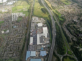
Birmingham Airport, formerly Birmingham International Airport, is an international airport located 7 nautical miles east-southeast of Birmingham city centre, 9.5 nautical miles west-northwest of Coventry slightly north of Bickenhill village, in the Metropolitan Borough of Solihull, England.
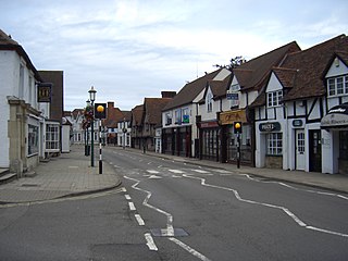
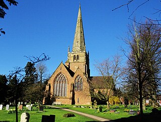
Knowle is a large village situated 3 miles (5 km) east-southeast of the town of Solihull, West Midlands, England. Knowle lies within the Arden area of the historic county boundaries of Warwickshire, and since 1974 it has been part of the Metropolitan Borough of Solihull within the West Midlands. It lies 2.5 miles from the Warwickshire border and had a recorded population of 10,678.

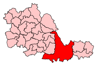
The Metropolitan Borough of Solihull is a metropolitan borough in West Midlands county, England. It is named after its largest town, Solihull, from which Solihull Metropolitan Borough Council is based. For Eurostat purposes it is a NUTS 3 region and is one of seven boroughs or unitary districts that comprise the "West Midlands" NUTS 2 region. Much of the large residential population in the north of the borough centres on the communities of Castle Bromwich, Kingshurst, Marston Green and Smith's Wood as well as the towns of Chelmsley Wood and Fordbridge. In the south are the towns of Shirley and Solihull, as well as the large villages of Knowle, Dorridge, Meriden and Balsall Common.
Castle Bromwich is a large suburban village and civil parish in the Metropolitan Borough of Solihull in the West Midlands, England. It borders the rest of the borough to the south east, Sutton Coldfield to the east and north east, Shard End to the south west, Castle Vale, Erdington and Minworth to the north and Hodge Hill to the west.

Chelmsley Wood, sometimes called just Chelmsley, is a town and civil parish in the Metropolitan Borough of Solihull, West Midlands, England, with a population of 12,453. It is located near Birmingham Airport and the National Exhibition Centre. It lies about eight miles east of Birmingham City Centre and 5 miles to the north of Solihull. The town is also close to both Coleshill and Water Orton in Warwickshire, the county the area was historically part of.
Meriden is a constituency represented in the House of Commons of the UK Parliament since 2019 by Saqib Bhatti, a Conservative. It is named after the village of Meriden, halfway between Solihull and Coventry.

Marston Green railway station is a station serving Chelmsley Wood and Marston Green in the Metropolitan Borough of Solihull and the Birmingham suburbs of Lea Hall and Sheldon in the West Midlands County, England. The station, and all trains serving it, are operated by West Midlands Trains.
Olton is an area/suburban village within the Metropolitan Borough of Solihull in the West Midlands, England. In the 13th century, the Lords of the Manor moved their seat and formed a new settlement, at the junction of two major roads. It was then that Ulverlei was being referred to as ‘Oulton’ to distinguish itself from nearby Solihull. Historically within the county of Warwickshire, the village has gradually become contiguous with Solihull to the southeast, though it retains the character of a large independent village.

Bickenhill is a village in the civil parish of Bickenhill and Marston Green, in the Metropolitan Borough of Solihull, in the West Midlands county, England, on the eastern fringe of the West Midlands conurbation. Bickenhill is also a ward and was within the historic county of Warwickshire. Birmingham Airport is also located within the civil parish.
Kingshurst is a post-war village and civil parish in the Metropolitan Borough of Solihull, in the West Midlands. It lies about 10 miles (16 km) east of Birmingham, and 10 miles (16 km) west of Coventry. It borders North Warwickshire to the east. Smith's Wood to the north, Fordbridge to the south and the Shard End area of Birmingham to the west.

Hockley Heath is a village and civil parish within the Metropolitan Borough of Solihull, West Midlands, England. The village is to the south of the West Midlands conurbation, 12 miles (19 km) southeast of Birmingham 5.5 miles (8.9 km) from Solihull town centre and 13 miles (21 km) north of Stratford-upon-Avon. Hockley Heath is in the Arden area and borders Warwickshire and the District of Stratford-on-Avon to the south, with some parts of the village on either side of the border. It incorporates the hamlet of Nuthurst, and has a history dating back to the year 705 AD as a wood owned by Worcester Cathedral. The 2011 Census gives the population of Hockley Heath civil parish as 2,038.
The Meriden Rural District was a rural district of Warwickshire, England, which existed between 1894 and 1974. It was named after the village of Meriden.
Solihull is a market town and the administrative centre of the Metropolitan Borough of Solihull, in the West Midlands, England. Solihull is situated on the River Blythe in the Forest of Arden area. The town had a population of 126,577 at the 2021 Census, and its wider borough had a population of 216,240. The town is located 8 miles (12 km) southeast of Birmingham and 13 miles (21 km) west of Coventry.

Elmdon is a suburban village in the civil parish of Bickenhill and Marston Green, in the Solihull district, in the county of the West Midlands, England. It is in the ancient county of Warwickshire. The population of this Solihull Ward at the 2011 census was 12,067. In 1931 the parish had a population of 225. On 1 April 1932 the parish was abolished and merged with Bickenhill and Solihull Urban.
Major's Green is a village in the Wythall parish of Bromsgrove district and is the northeastern-most settlement in the county of Worcestershire, England.
Meriden and Solihull East is a proposed constituency of the House of Commons in the UK Parliament. Further to the completion of the 2023 Periodic Review of Westminster constituencies, it will first be contested at the next general election. The constituency name refers to the village of Meriden and the eastern areas of the Metropolitan Borough of Solihull. This is part of a boundary review that will result in the Solihull constituency being split into three.

