Massapequa Park, New York

Last updated

Massapequa Park, New York
Incorporated Village of Massapequa Park
Welcome to Massapequa Park.jpg
A welcome sign at an entrance to Massapequa Park in 2016
Nickname(s): 
"Masspark"; "The Park"
Nassau County New York incorporated and unincorporated areas Massapequa Park highlighted.svg
Location in Nassau County and the state of New York.
Location map Long Island.png
Red pog.svg
Massapequa Park, New York
Location on Long Island
USA New York location map.svg
Red pog.svg
Massapequa Park, New York
Location within the state of New York
Coordinates: 40°41′4″N73°26′58″W / 40.68444°N 73.44944°W / 40.68444; -73.44944
Country Flag of the United States.svg  United States
State Flag of New York.svg  New York
County Nassau
Town Oyster Bay
Incorporated 1931
Government
   Mayor Daniel M. Pearl
Area
[1]
  Total2.25 sq mi (5.82 km2)
  Land2.19 sq mi (5.68 km2)
  Water0.06 sq mi (0.14 km2)
Elevation
23 ft (7 m)
Population
 (2020)
  Total17,109
  Density7,805.20/sq mi (3,013.76/km2)
Time zone UTC-5 (Eastern (EST))
  Summer (DST) UTC-4 (EDT)
ZIP code
11762
Area codes 516, 363
FIPS code 36-45997
GNIS feature ID2390968
Website masspk.com

Massapequa Park is an incorporated village located within the southern portion of the Town of Oyster Bay in Nassau County, on the South Shore of Long Island, in New York. The population was 17,008 at the 2010 census.

Contents

The areas south and east of the village borders are considered the hamlet of Massapequa because they are under the jurisdiction of the Town of Oyster Bay rather than the village. The hamlet shares the same zip code, fire department and school district as the village.

History

The village located on the South Shore of Long Island shares the early Native American history of Massapequa. Then in the 19th century, families of German descent relocated from Brooklyn to what is now Massapequa Park, and the community which was formed was known as Wurtenberg or Stadtwurtemburg. The main attraction and center of activity was the Woodcastle Hotel, a rooming house built in 1868 on Front Street next to the fire department as a summer resort. It was destroyed by fire in 1952 and replaced by houses.[ citation needed ]

In 1928, The New York Times ran ads for Massapequa Park, a development built by a real estate firm owned by Michael J. Brady, Frank Cryan, and Peter Colleran. The three Irish-Americans described their project as having a bit of Old Erin; the area between Sunrise Highway and Merrick Road still has mostly Irish street names.[ citation needed ]

In 1931, Massapequa Park was incorporated as a village to ensure control of land use and other issues. [2] [3] Several dozen kit houses from Sears Roebuck were built in two different areas of the village. These include some of the largest model kit houses offered by Sears. [4]

The village once had its own airport, the Fitzmaurice Flying Field, named in 1929 for James Fitzmaurice, one of a crew of three to be the first to fly a plane from east to west across the Atlantic (Baldonnel, Ireland to Greenly Island in Labrador, Canada). An estimated 100,000 people came to the dedication of the field on Spruce Street. [5] The field was used by private planes.

The field was eventually closed and became the home for the athletic fields of the 4M Club, a popular youth athletic program founded by Larry Neusse, and supported by a wide range of local residents. Today the site is home to McKenna Elementary School (which used to be a junior high school) and the Nassau County Police Academy (which used to be Hawthorn Elementary School). [6]

Geography

U.S. Census map of Massapequa Park Massapegua-park-map.gif
U.S. Census map of Massapequa Park

According to the United States Census Bureau, the village has a total area of 1.6 square miles (4.1 km2), all land, of which 2.19 square miles (5.7 km2) is land and 0.06 square miles (0.16 km2) is water. [7]

Massapequa Park is bordered by Massapequa to the west, East Massapequa to the east, North Massapequa to the northwest, and South Farmingdale to the north. To its south, the village is bordered by South Oyster Bay–a large bay separating Long Island from Jones Beach Island.

Demographics

Historical population
CensusPop.Note
1940 488
1950 2,334378.3%
1960 19,904752.8%
1970 22,11211.1%
1980 19,779−10.6%
1990 18,044−8.8%
2000 17,499−3.0%
2010 17,008−2.8%
2020 17,1090.6%
U.S. Decennial Census [8]

As of the 2010 census, there were 17,008 people, 5,731 households, and 4,736 families residing in the village. There were 5,844 housing units at an average density of 2,656.4 per square mile (1,025.6/km2). The racial makeup of the village was 96.9% White, 0.3% African American, 0.04% Native American, 1.5% Asian, 0.01% Pacific Islander, 0.5% from other races, and 0.7% from two or more races. Hispanic or Latino of any race were 4.5% of the population. [9]

There were 5,731 households, out of which 36.4% had children under the age of 18 living with them, 70.7% were headed by married couples living together, 9.2% had a female householder with no husband present, and 17.4% were non-families. 14.9% of all households were made up of individuals, and 9.2% were someone living alone who was 65 years of age or older. The average household size was 2.97 and the average family size was 3.31. [9]

In the village, the population was spread out, with 24.6% under the age of 18, 6.5% from 18 to 24, 23.2% from 25 to 44, 29.5% from 45 to 64, and 16.1% who were 65 years of age or older. The median age was 42.5 years. For every 100 females, there were 94.1 males. For every 100 females age 18 and over, there were 89.6 males. [9]

The three main ethnic backgrounds are Italian [45%], Irish [28%] and German [18%], comprising over three-fourths of the village's population. The rest of the population is of English, Russian, Polish, Swedish, Scottish, Greek, French, Dutch, and other background. [9]

The median income in the village for 2010 was $98,725 and the median income for a family was $110,417. The per capita income for the village was $38,226. About 1.0% of families and 1.4% of the population were below the poverty line, including 1.3% of those under age 18 and 2.5% of those age 65 or over. [9]

Government

As of July 2023, the Mayor of Massapequa Park is Daniel M. Pearl, and the Village Trustees are Dana M. Durso, Tina Schiaffino, Todd A. Svec, and Christine M. Wiss. [10]

The Mayor and members of the Board of Trustees are each elected to two-year terms, and the village elections are held in March. [10]

Parks and recreation

The Village of Massapequa Park owns and operates three parks main: Brady Park, Colleran Park, and Mansfield Park. [11] It also owns and maintain several memorials and associated parks which are located throughout the village. [12]

Education

The village is located within the boundaries of (and is thus served by) the Massapequa Union Free School District. [13]

During the 1960s, 1970s and much of the 1980s the Massapequa School District had seven elementary schools (Carman Road, East Lake, Birch Lane, Fairfield, Unqua, Hawthorn, Lockhart), two junior high schools (McKenna and Ames) and two high schools (Massapequa and Alfred G. Berner).

In 1987, the Massapequa school district restructured the district by leasing Carmans Road elementary to Nassau BOCES and Hawthorne Elementary to the Nassau County Police Academy. John P. McKenna Jr. High School was converted to an elementary school, while Alfred G. Berner became the new junior high, later becoming a middle school. J. Lewis Ames Jr. High School is no longer a middle school, but a "9th Grade Center"– the Ames Campus of Massapequa High School. The northern section of the village and hamlet are served by the Farmingdale School District. [13]

Transportation

The Long Island Rail Road's Massapequa Park station on the Babylon Branch is located in the village. [13] [14]

Major roads within the village include Merrick Road (CR 27) and Sunrise Highway (NY 27). [13] Furthermore, the Village of Massapequa Park owns roughly 30 miles (48 km) of roads, which are maintained by the Village of Massapequa Park Department of Public Works. [15]

Notable people

Related Research Articles

<span class="mw-page-title-main">Nassau County, New York</span> County in New York, United States

Nassau County is a suburban county located immediately to the east of New York City. As of the 2020 United States census, Nassau County's population was 1,395,774, making it the sixth-most populous county in the State of New York, and reflecting an increase of 56,242 (+4.2%) from the 1,339,532 residents enumerated at the 2010 census. Its county seat is Mineola, while the county's largest town is Hempstead. The county is part of the Long Island region of the state, lying in its southeastern portion along with the remainder of the island.

<span class="mw-page-title-main">East Hills, New York</span> Village in New York, United States

East Hills is a village in Nassau County, on the North Shore of Long Island, in New York, United States. It is considered part of the Greater Roslyn area, which is anchored by the Incorporated Village of Roslyn. The population was 7,284 at the time of the 2020 census.

<span class="mw-page-title-main">East Massapequa, New York</span> Hamlet and census-designated place in New York, United States

East Massapequa is a hamlet and census-designated place (CDP) located within the Town of Oyster Bay in Nassau County, on the South Shore of Long Island, in New York, United States. The population was 19,069 at the 2010 census.

<span class="mw-page-title-main">Farmingdale, New York</span> Village in New York, United States

Farmingdale is an incorporated village on Long Island within the Town of Oyster Bay in Nassau County, New York, United States. The population was 8,466 at the time of the 2020 Census.

<span class="mw-page-title-main">Greenvale, New York</span> Hamlet and census-designated place in New York, United States

Greenvale is a hamlet and census-designated place (CDP) in the towns of North Hempstead and Oyster Bay in Nassau County, on the North Shore of Long Island, in New York, United States. It is considered part of the Greater Roslyn area, which is anchored by the Incorporated Village of Roslyn. The population was 1,069 at the time of the 2020 census.

<span class="mw-page-title-main">Hicksville, New York</span> Hamlet and census-designated place in New York, United States

Hicksville is a hamlet and census-designated place (CDP) within the Town of Oyster Bay in Nassau County, on Long Island, in New York. The population of the CDP was 43,869 at the 2020 census.

<span class="mw-page-title-main">Massapequa, New York</span> Hamlet and census-designated place in New York, United States

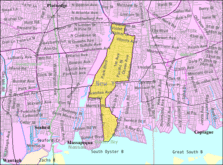
Massapequa is a hamlet and census-designated place (CDP) in the Town of Oyster Bay in Nassau County, on the South Shore of Long Island, in New York, United States. The population of the CDP was 21,355 at the time of the 2020 census.

<span class="mw-page-title-main">North Massapequa, New York</span> Hamlet and census-designated place in New York, United States

North Massapequa is a hamlet and census-designated place (CDP) located on Long Island within the Town of Oyster Bay in Nassau County, on Long Island, in New York, United States. It is considered part of the Greater Massapequa area, which is anchored by Massapequa. The population was 17,886 at the 2010 census.

<span class="mw-page-title-main">Old Bethpage, New York</span> Hamlet and census-designated place in New York, United States

Old Bethpage is a hamlet and census-designated place (CDP) located on Long Island in the Town of Oyster Bay, Nassau County, New York, United States. The population of the CDP was 5,283 at the 2020 United States Census. It is served by the Old Bethpage Post Office, ZIP code 11804.

<span class="mw-page-title-main">Searingtown, New York</span> Hamlet and census-designated place in New York, United States

Searingtown is a hamlet and census-designated place (CDP) in the Town of North Hempstead in Nassau County, on Long Island, in New York, United States. It is considered part of the Greater Roslyn area, which is anchored by the Village of Roslyn. The population was 4,915 at the 2010 census.

<span class="mw-page-title-main">South Farmingdale, New York</span> Hamlet and census-designated place in New York, United States

South Farmingdale is a hamlet and census-designated place (CDP) in the Town of Oyster Bay in Nassau County, on the South Shore of Long Island, in New York, United States. It is considered part of the Greater Farmingdale area, which is anchored by Farmingdale. The population of the CDP was 14,345 at the 2020 census.

<span class="mw-page-title-main">Valley Stream, New York</span> Village in New York, United States

Valley Stream is a village in Nassau County, on Long Island, in New York, United States. The population in the Village of Valley Stream was 37,511 at the 2010 census.

<span class="mw-page-title-main">Amityville, New York</span> Village in New York, United States

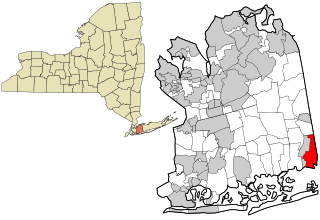
Amityville is a village in the Town of Babylon in Suffolk County, on the South Shore of Long Island, in New York, United States. The population was 9,523 at the 2010 census.

<span class="mw-page-title-main">Babylon, New York</span> Town in New York, United States

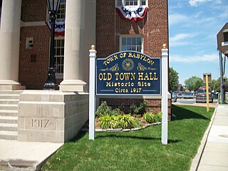
The Town of Babylon is one of ten towns in Suffolk County, New York, United States. Its population was 218,223 as of the 2020 census. Parts of Jones Beach Island, Captree Island and Fire Island are in the southernmost part of the town. It borders Nassau County to the west and the Atlantic Ocean to the south. At its westernmost point, it is about 20 miles (32 km) from New York City at the Queens border, and about 30 miles (48 km) from Manhattan. The village of Babylon is also within the town.

<span class="mw-page-title-main">Jones Beach Island</span>

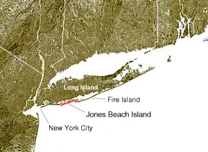
Jones Beach Island is one of the outer barrier islands off the southern coast of Long Island in the U.S. state of New York.

<span class="mw-page-title-main">South Shore (Long Island)</span> Southern edge of Long Island in New York state

The South Shore of Long Island, in the U.S. state of New York, is the area along Long Island's Atlantic Ocean shoreline.

<span class="mw-page-title-main">New York's 2nd congressional district</span> U.S. House district for New York

New York's 2nd congressional district is a congressional district for the United States House of Representatives along the South Shore of Long Island, New York. It includes southwestern Suffolk County and a small portion of southeastern Nassau County. The district is currently represented by Republican Andrew Garbarino.

<span class="mw-page-title-main">Oyster Bay, New York</span> Town in New York, United States

The Town of Oyster Bay is the easternmost of the three towns that make up Nassau County, New York, United States. Part of the New York metropolitan area, it is the only town in Nassau County to extend from the North Shore to the South Shore of Long Island. As of the 2020 census, it had a population of 301,332, Making it the 5th most populous city or town in the state.

<span class="mw-page-title-main">Massapequa High School</span> School in Massapequa, New York, United States

Massapequa High School is a public high school located in Massapequa, in Nassau County, on Long Island, in New York, United States. It serves students in grades 10 through 12.

<span class="mw-page-title-main">Tobay Beach</span>

Tobay Beach is a restricted access recreational beach located in the middle of Jones Beach Island, a barrier island off the South Shore of Long Island, Nassau County, New York, United States, within the Massapequa 11758 Zip code. Its name is a portmanteau for the Town of Oyster Bay, which owns and manages the beach. Residents of the town are allowed entry, with limited access for non-residents.

References

  1. "ArcGIS REST Services Directory". United States Census Bureau. Retrieved September 20, 2022.
  2. Winsche, Richard (October 1, 1999). The History of Nassau County Community Place-Names. Interlaken, New York: Empire State Books. ISBN   978-1557871541.
  3. "About Us | Village of Massapequa Park" . Retrieved August 13, 2021.
  4. "Sears Houses of Massapequa Park, New York". October 12, 2015. Retrieved December 8, 2015.
  5. "Massapequa - The City of Homes". Massapequa Chamber of Commerce. Archived from the original on July 17, 2012. Retrieved October 9, 2012.
  6. "FITZMAURICE FIELD BOWING TO SCHOOL; ' Cow Pasture' Airport Closed to Permit Expansion of Education in Nassau". The New York Times. June 21, 1953. ISSN   0362-4331 . Retrieved August 30, 2022.
  7. "US Gazetteer files: 2010, 2000, and 1990". United States Census Bureau. February 12, 2011. Retrieved April 23, 2011.
  8. "Census of Population and Housing". Census.gov. Retrieved June 4, 2015.
  9. 1 2 3 4 5 "Profile of General Population and Housing Characteristics: 2010 Demographic Profile Data (DP-1): Massapequa Park village, New York". United States Census Bureau . Retrieved October 9, 2012.
  10. 1 2 "Government | Village of Massapequa Park" . Retrieved July 16, 2023.
  11. "Parks & Recreation | Village of Massapequa Park" . Retrieved July 16, 2023.
  12. "Memorials | Village of Massapequa Park" . Retrieved July 16, 2023.
  13. 1 2 3 4 "Long Island Index: Interactive Map". www.longislandindexmaps.org. Retrieved August 30, 2022.
  14. "MTA LIRR - Massapequa Park". lirr42.mta.info. Retrieved July 16, 2023.
  15. "Public Works | Village of Massapequa Park" . Retrieved July 16, 2023.
  16. "Gilgo Beach murders: Architect charged in Long Island serial killer case". BBC News. July 14, 2023. Retrieved July 15, 2023.