

The Mauna Loa Observatory (MLO) is an atmospheric baseline station on Mauna Loa, on the island of Hawaii, located in the U.S. state of Hawaii.
Contents


The Mauna Loa Observatory (MLO) is an atmospheric baseline station on Mauna Loa, on the island of Hawaii, located in the U.S. state of Hawaii.
The Mauna Loa Observatory was founded on June 28th 1956 as part of the US Weather Bureau. It was established on the northern flank of Mauna Loa at 11,134 ft after 1951-1954 efforts were unable to maintain a summit observatory at 13,453 ft. [1]
The Mauna Loa Observatory was developed specifically to monitor solar, atmospheric and meteorological parameters in the free atmosphere. Establishment of a solar constant, [2] routine weather observations, the determination of ozone and monitoring atmospheric circulation were early priorities. Continuous carbon dioxide measurements began in March of 1958 directed by Charles David Keeling from the Scripps Institute of Oceanography. The data set, referred to as the Keeling Curve, is the foundational study in the composition and behavior of greenhouse gases in the atmosphere. Other early research at the observatory included; measurements of cosmic radiation, the atmosphere of Mars, atomic fallout, snow crystals, the solar corona, meteors, cosmic rays and radio transmission. The International Geophysical Year enabled many of the early projects at the observatory secure support and funding. [3]
The Mauna Loa Observatory has been part of the National Oceanic and Atmospheric Administration (NOAA) Global Monitoring Laboratory’s Baseline Observatory network since 1972. The observatory's location, far from continental sources of emissions and above the marine inversion layer make it an ideal site for atmospheric monitoring. The absence of continental weather patterns, lack of vegetation and a predictable diurnal wind pattern provide routine access to clean well mixed air from the free troposphere.
In addition to NOAA-GML projects the observatory campus remains host to projects from partner institutions, governmental organizations and universities from around the world. The Mauna Loa Solar Observatory and NSF's Global Oscillations Network Group (GONG) station share this site. The observatory site is also a temporary home to a cosmic microwave background observatory called YTLA. [4]
The observatory is located at the end of the Mauna Loa Observatory Access Road and there is no public bathroom. Gated access to the observatory is managed by NOAA. The northern trailhead to the summit of Mauna Loa is located below the observatory site and is managed by Hawaii Volcanoes National Park. It passes through State of Hawaii conservation land managed by the Hawaii Department of Land and Natural Resources.
The access road was obstructed by lava flow from the 2022 eruption of Mauna Loa. As of February 2023, deposits continue to block vehicular access to the observatory. [5] Utility lines that powered the facility were also damaged, further impeding operation. Temporary solar power has been established, which allows the observatory to operate at approximately 33 percent of its full capacity. [6] This is as renovations are underway to upgrade the facility with new power distribution infrastructure.

Mauna Loa is one of five volcanoes that form the Island of Hawaii in the U.S. state of Hawaii in the Pacific Ocean. Mauna Loa is Earth's largest active volcano by both mass and volume. It was historically considered to be the largest volcano on Earth until Tamu Massif was discovered to be larger. Mauna Loa is a shield volcano with relatively gentle slopes, and a volume estimated at 18,000 cubic miles (75,000 km3), although its peak is about 125 feet (38 m) lower than that of its neighbor, Mauna Kea. Lava eruptions from Mauna Loa are silica-poor and very fluid, and tend to be non-explosive.

Mauna Kea is an inactive shield volcano on the island of Hawaiʻi. Its peak is 4,207.3 m (13,803 ft) above sea level, making it the highest point in Hawaii and second-highest peak of an island on Earth. The peak is about 38 m (125 ft) higher than Mauna Loa, its more massive neighbor. Mauna Kea is unusually topographically prominent for its height: its wet prominence is fifteenth in the world among mountains, at 4,205 m (13,796 ft); its dry prominence is 9,330 m (30,610 ft). This dry prominence is greater than Mount Everest's height above sea level of 8,848.86 m (29,032 ft), and some authorities have labeled Mauna Kea the tallest mountain in the world, from its underwater base. Mauna Kea is ranked 8th by topographic isolation.

Kīlauea is an active shield volcano in the Hawaiian Islands. It is located along the southeastern shore of Hawaii Island. The volcano is between 210,000 and 280,000 years old and grew above sea level about 100,000 years ago. Since the islands were settled it has been the most active of the five volcanoes that together form the island.

Hawaiʻi Volcanoes National Park is an American national park located in the U.S. state of Hawaii on the island of Hawaii. The park encompasses two active volcanoes: Kīlauea, one of the world's most active volcanoes, and Mauna Loa, the world's largest shield volcano. The park provides scientists with insight into the development of the Hawaiian Islands and access for studies of volcanism. For visitors, the park offers dramatic volcanic landscapes, glimpses of rare flora and fauna, and a view into the traditional Hawaiian culture connected to these landscapes.
This glossary of climate change is a list of definitions of terms and concepts relevant to climate change, global warming, and related topics.
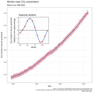
The Keeling Curve is a graph of the accumulation of carbon dioxide in the Earth's atmosphere based on continuous measurements taken at the Mauna Loa Observatory on the island of Hawaii from 1958 to the present day. The curve is named for the scientist Charles David Keeling, who started the monitoring program and supervised it until his death in 2005.

The Haleakalā Observatory, also known as the Haleakalā High Altitude Observatory Site, is Hawaii's first astronomical research observatory. It is located on the island of Maui and is owned by the Institute for Astronomy of the University of Hawaiʻi, which operates some of the facilities on the site and leases portions to other organizations. Tenants include the Air Force Research Laboratory (AFRL) and the Las Cumbres Observatory Global Telescope Network (LCOGTN). At over 3,050 meters (10,010 ft) in altitude, the summit of Haleakalā is above one third of the Earths's troposphere and has excellent astronomical seeing conditions.
This is a list of meteorology topics. The terms relate to meteorology, the interdisciplinary scientific study of the atmosphere that focuses on weather processes and forecasting.

Charles David Keeling was an American scientist whose recording of carbon dioxide at the Mauna Loa Observatory confirmed Svante Arrhenius's proposition (1896) of the possibility of anthropogenic contribution to the greenhouse effect and global warming, by documenting the steadily rising carbon dioxide levels. The Keeling Curve measures the progressive buildup of carbon dioxide, a greenhouse gas, in the atmosphere.

Mauna Loa Solar Observatory (MLSO) is a solar observatory located on the slopes of Mauna Loa on the island of Hawaii in the U.S. state of Hawaii. It is operated by the High Altitude Observatory (HAO), a laboratory within the National Center for Atmospheric Research (NCAR). The MLSO sits on property managed by the Mauna Loa Observatory (MLO), which is part of the U.S. Department of Commerce National Oceanic and Atmospheric Administration (NOAA). MLSO was built in 1965.

A Hawaiian eruption is a type of volcanic eruption where lava flows from the vent in a relatively gentle, low level eruption; it is so named because it is characteristic of Hawaiian volcanoes. Typically they are effusive eruptions, with basaltic magmas of low viscosity, low content of gases, and high temperature at the vent. Very small amounts of volcanic ash are produced. This type of eruption occurs most often at hotspot volcanoes such as Kīlauea on Hawaii's big island and in Iceland, though it can occur near subduction zones and rift zones. Hawaiian eruptions may occur along fissure vents, such as during the eruption of Mauna Loa in 1950, or at a central vent, such as during the 1959 eruption in Kīlauea Iki Crater, which created a lava fountain 580 meters (1,900 ft) high and formed a 38-meter cone named Puʻu Puaʻi. In fissure-type eruptions, lava spurts from a fissure on the volcano's rift zone and feeds lava streams that flow downslope. In central-vent eruptions, a fountain of lava can spurt to a height of 300 meters or more.

The US National Center for Atmospheric Research is a US federally funded research and development center (FFRDC) managed by the nonprofit University Corporation for Atmospheric Research (UCAR) and funded by the National Science Foundation (NSF). NCAR has multiple facilities, including the I. M. Pei-designed Mesa Laboratory headquarters in Boulder, Colorado. Studies include meteorology, climate science, atmospheric chemistry, solar-terrestrial interactions, environmental and societal impacts.
The State of the Climate is an annual report that is primarily led by the National Oceanic and Atmospheric Administration National Climatic Data Center (NOAA/NCDC), located in Asheville, North Carolina, but whose leadership and authorship spans roughly 100 institutions in about 50 countries.
The High Altitude Observatory (HAO) is a laboratory of the US National Center for Atmospheric Research (NCAR). HAO operates the Mauna Loa Solar Observatory on Hawaii and a research institute in Boulder, Colorado.
The Cape Kumukahi Light is a lighthouse in Kapoho, Hawaii at the easternmost point of Hawaii. It is best known for its survival of an eruption of Kilauea in 1960.

Greenhouse gas monitoring is the direct measurement of greenhouse gas emissions and levels. There are several different methods of measuring carbon dioxide concentrations in the atmosphere, including infrared analyzing and manometry. Methane and nitrous oxide are measured by other instruments. Greenhouse gases are measured from space such as by the Orbiting Carbon Observatory and networks of ground stations such as the Integrated Carbon Observation System.

The Dr. Neil Trivett Global Atmosphere Watch Observatory is an atmospheric baseline station operated by Environment and Climate Change Canada located about 6 km (3.7 mi) south south-west of Alert, Nunavut, on the north-eastern tip of Ellesmere Island, about 800 km (500 mi) south of the geographic North Pole.

The 1975 eruption of Mauna Loa was a short-lived Hawaiian eruption that followed 25 years of quiescence at the Hawaiian volcano Mauna Loa. The eruption began just before midnight on July 5 and involved fissures extending across the length of Moku‘āweoweo, Mauna Loa's summit caldera, and into the upper ends of the volcano's northeast and southwest rift zones. After only 6 hours, activity in Moku‘āweoweo and on the southwest rift zone ended, but lava fountaining continued along the northeast rift zone until 7:30 p.m. on July 6, when all activity ceased.

Lester Machta was an American meteorologist, the first director of the Air Resources Laboratory (ARL) of the National Oceanic and Atmospheric Administration.

The 2022 eruption of Mauna Loa was an episode of eruptive volcanic activity at Mauna Loa, the world's largest active volcano, located on Hawaiʻi island, Hawaiʻi. Mauna Loa began to erupt shortly before midnight HST on November 27, 2022, when lava flows emerged from fissure vents in Moku‘āweoweo. It marked the first eruption at the volcano in 38 years. The eruption ended on December 13, 2022, after more than two weeks.
| International | |
|---|---|
| National | |