
Gran Sasso d'Italia (Italian: [ɡran ˈsasso diˈtaːlja] is a massif in the Apennine Mountains of Italy. Its highest peak, Corno Grande, is the highest mountain in the Apennines, and the second-highest mountain in Italy outside the Alps. The mountain lies within Gran Sasso e Monti della Laga National Park.

Valle San Giovanni is a small village in the province of Teramo, in the Abruzzo region of central Italy. It is a frazione of the town of Teramo.

The Province of Teramo is a province in the Abruzzo region of Italy. Its capital is the city of Teramo. The province has an area of 1,948 square kilometres (752 sq mi), a population of 313,029 (2012), and is subdivided into 47 comunes, see Comunes of the Province of Teramo. The Province of Teramo shares its northern border with the Province of Ascoli Piceno in the Marche Region, southern and southwestern borders with the Province of L'Aquila in the Abruzzo Region, and a western border with the Province of Rieti in the Region of Lazio. To the south is the Abruzzo Province of Pescara and to the east is the Adriatic Sea.

Frondarola is a small town in the province of Teramo in the Abruzzo region of Italy, population about 200. It lies at an altitude of 1502 feet above sea level and is located about 5 miles from Teramo, of which it is a frazione.

Villa Vomano is a small village in the province of Teramo, in the Abruzzo region of central Italy. It is a frazione of the town of Teramo.

Montorio al Vomano is a town and comune in the province of Teramo, in the Abruzzo region of central-southern Italy. It is located in the natural park known as the Gran Sasso e Monti della Laga National Park.

Monti della Laga is a mountain range in the central Apennines of Italy. Their ruggedness and inaccessibility makes them one of the lesser known areas of the Italian peninsula.

Isola del Gran Sasso d'Italia is a town and comune in province of Teramo in the Abruzzo region of southern Italy. It is located in the Gran Sasso e Monti della Laga National Park. The Gran Sasso mountain is the highest mountain in the Apennine chain in Italy.

Crognaleto is a comune and city of slightly less than 2,000 people in the Province of Teramo, central Italy. Crognaleto sits at an elevation of 1,105 metres (3,625 ft) and has its communal administrative offices in the frazione of Nerito. The commune of Crognaleto sits on the slopes of the Monti della Laga mountain range and extends across both the northern and the southern slopes of the Vomano Valley. It lies within the Gran Sasso e Monti della Laga National Park.

Collevecchio is a small village in the Abruzzo region of Italy. It is a frazione of the comune of Montorio al Vomano.
The Grand Highway of the Gran Sasso and Monti della Laga National Park is located in the Abruzzo Region of east−central Italy.

The Gran Sasso and Monti della Laga National Park is a natural park located mostly in Abruzzo, Italy. Established in 1991, it has an area of 2,014 square kilometres (778 sq mi), and it is mainly spread out across the province of Teramo, L'Aquila, Pescara, with small areas in the province of Rieti and Ascoli Piceno. The terrain is predominantly mountainous with alpine plains.

The Capannelle Pass is a mountain pass in Italy. It sits at an altitude of 1300 meters above sea level in the Province of L'Aquila in Italy's Abruzzo Region. It is located on the Italian State Highway 80 which passes near the Gran Sasso in the Apennines.
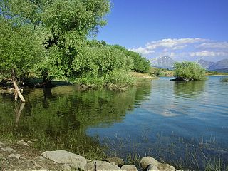
Lago di Campotosto is an artificial lake in Abruzzo, Italy. The reservoir is located at an elevation of 1,313 m and comprises an area of 14 square kilometres. It is located in the natural park known as the "Gran Sasso e Monti della Laga National Park".
Gran Sasso may refer to any of several nearby locations among Gran Sasso d'Italia, the highest mountain in central Italy:

The 24th Infantry Division Pinerolo was an infantry division of the Italian Army during World War II.
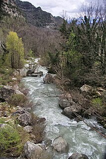
The Vomano is a 76 km river, which is in the Abruzzo region of Italy. Its source is near Monte San Franco in Gran Sasso d'Italia and Lago di Campotosto in the province of L'Aquila. The river crosses the border into the province of Teramo and flows northeast near Montorio al Vomano and Basciano. The Fucino flows into the Vomano south of Crognaleto and the Mavone flows into the Vomano near Basciano. It enters the Adriatic Sea near Roseto degli Abruzzi.

Figliola is a frazione of the comune of Crognaleto, in the Province of Teramo within the Abruzzo Region of Italy. It is between the towns of Crognaleto, San Giorgio and Aiello in the Vomano Valley. Figliola faces the Gran Sasso and can be reached via a road that is partially paved.
The Tavo is a river in the Abruzzo region of Italy. Its source is in the Gran Sasso d'Italia mountain range in the province of L'Aquila near the border with the province of Pescara. After crossing the border, the river loops northward and then eastward near Penne. It then flows south and then northeast and flows near Loreto Aprutino and Pianella. The river continues flowing northeast near Cappelle sul Tavo before joining the Fino and together they become the Saline.
The Fucino is a river in Italy. It is located in the province of Teramo in the Abruzzo region of southern Italy. The river is a tributary of the Vomano. Its source is Lake Campotosto near the border with the province of L'Aquila. The river flows northeast before joining the Vomano south of Crognaleto.
