Mayetta, Kansas

Last updated

Mayetta, Kansas
Downtown Mayetta, Kansas.jpg
Downtown Mayetta (2007)
Jackson County Kansas Incorporated and Unincorporated areas Mayetta Highlighted.svg
Location within Jackson County and Kansas
Map of Jackson Co, Ks, USA.png
Coordinates: 39°20′19″N95°43′17″W / 39.33861°N 95.72139°W / 39.33861; -95.72139 [1]
Country United States
State Kansas
County Jackson
Platted 1886
Named for Mary Lunger
Area
[2]
  Total0.17 sq mi (0.44 km2)
  Land0.17 sq mi (0.44 km2)
  Water0.00 sq mi (0.00 km2)
Elevation
[1]
1,191 ft (363 m)
Population
 (2020) [3]
  Total348
  Density2,000/sq mi (790/km2)
Time zone UTC-6 (CST)
  Summer (DST) UTC-5 (CDT)
ZIP code
66509
Area code 785
FIPS code 20-45250
GNIS ID 2395050 [1]
Website mayetta.org

Mayetta is a city in Jackson County, Kansas, United States. [1] As of the 2020 census, the population is 348. [3]

Contents

History

Mayetta was laid out and platted in 1886. [4] It was named after Mary Henrietta Lunger, the town founder's young daughter who had died some time before. [5] [6]

The first post office in Mayetta was established in February 1886. [7]

Geography

According to the United States Census Bureau, the city has a total area of 0.17 square miles (0.44 km2), all of it land. [8]

Demographics

Historical population
CensusPop.Note
1910 337
1920 309−8.3%
1930 294−4.9%
1940 275−6.5%
1950 247−10.2%
1960 218−11.7%
1970 24612.8%
1980 28716.7%
1990 267−7.0%
2000 31216.9%
2010 3419.3%
2020 3482.1%
U.S. Decennial Census

Mayetta is part of the Topeka, Kansas Metropolitan Statistical Area.

2020 census

The 2020 United States census counted 348 people, 134 households, and 92 families in Mayetta. [9] [10] The population density was 2,059.2 per square mile (795.0/km2). There were 142 housing units at an average density of 840.2 per square mile (324.4/km2). [10] [11] The racial makeup was 72.7% (253) white or European American (70.4% non-Hispanic white), 0.86% (3) black or African-American, 18.1% (63) Native American or Alaska Native, 0.0% (0) Asian, 0.57% (2) Pacific Islander or Native Hawaiian, 0.0% (0) from other races, and 7.76% (27) from two or more races. [12] Hispanic or Latino of any race was 6.32% (22) of the population. [13]

Of the 134 households, 39.6% had children under the age of 18; 40.3% were married couples living together; 29.9% had a female householder with no spouse or partner present. 23.1% of households consisted of individuals and 14.2% had someone living alone who was 65 years of age or older. [10] The average household size was 2.7 and the average family size was 3.3. [14] The percent of those with a bachelor’s degree or higher was estimated to be 9.2% of the population. [15]

24.1% of the population was under the age of 18, 12.4% from 18 to 24, 26.4% from 25 to 44, 24.1% from 45 to 64, and 12.9% who were 65 years of age or older. The median age was 33.0 years. For every 100 females, there were 94.4 males. [10] For every 100 females ages 18 and older, there were 91.3 males. [10]

The 2016-2020 5-year American Community Survey estimates show that the median household income was $41,250 (with a margin of error of +/- $10,851) and the median family income was $44,375 (+/- $10,700). [16] Males had a median income of $32,500 (+/- $6,486) versus $24,375 (+/- $5,962) for females. The median income for those above 16 years old was $30,192 (+/- $5,988). [17] Approximately, 13.2% of families and 9.9% of the population were below the poverty line, including 11.9% of those under the age of 18 and 17.1% of those ages 65 or over. [18] [19]

2010 census

As of the census [20] of 2010, there were 341 people, 125 households, and 85 families living in the city. The population density was 2,005.9 inhabitants per square mile (774.5/km2). There were 131 housing units at an average density of 770.6 per square mile (297.5/km2). The racial makeup of the city was 82.1% White, 1.5% African American, 11.1% Native American, 0.3% from other races, and 5.0% from two or more races. Hispanic or Latino of any race were 2.1% of the population.

There were 125 households, of which 43.2% had children under the age of 18 living with them, 42.4% were married couples living together, 16.8% had a female householder with no husband present, 8.8% had a male householder with no wife present, and 32.0% were non-families. 26.4% of all households were made up of individuals, and 10.4% had someone living alone who was 65 years of age or older. The average household size was 2.73 and the average family size was 3.15.

The median age in the city was 32.5 years. 32.8% of residents were under the age of 18; 7% were between the ages of 18 and 24; 29.5% were from 25 to 44; 22.8% were from 45 to 64; and 7.6% were 65 years of age or older. The gender makeup of the city was 52.5% male and 47.5% female.

2000 census

As of the census [21] of 2000, there were 312 people, 111 households, and 75 families living in the city. The population density was 1,888.7 inhabitants per square mile (729.2/km2). There were 121 housing units at an average density of 732.5 per square mile (282.8/km2). The racial makeup of the city was 80.77% White, 14.10% Native American, 0.32% from other races, and 4.81% from two or more races. Hispanic or Latino of any race were 0.96% of the population.

There were 111 households, out of which 46.8% had children under the age of 18 living with them, 51.4% were married couples living together, 15.3% had a female householder with no husband present, and 32.4% were non-families. 24.3% of all households were made up of individuals, and 9.9% had someone living alone who was 65 years of age or older. The average household size was 2.81 and the average family size was 3.40.

In the city, the population was spread out, with 37.2% under the age of 18, 8.0% from 18 to 24, 31.4% from 25 to 44, 15.1% from 45 to 64, and 8.3% who were 65 years of age or older. The median age was 28 years. For every 100 females, there were 97.5 males. For every 100 females age 18 and over, there were 90.3 males.

The median income for a household in the city was $38,542, and the median income for a family was $43,500. Males had a median income of $25,313 versus $21,500 for females. The per capita income for the city was $14,800. About 2.4% of families and 3.9% of the population were below the poverty line, including 4.4% of those under age 18 and 4.5% of those age 65 or over.

Economy

The Prairie Band Casino & Resort has operated, under various management, since 1998.

Education

The community is served by Royal Valley USD 337 public school district.

Notable people

Related Research Articles

<span class="mw-page-title-main">Garnett, Kansas</span> City in Anderson County, Kansas

Garnett is a city in and the county seat of Anderson County, Kansas, United States. As of the 2020 census, the population of the city was 3,242.

<span class="mw-page-title-main">Isabel, Kansas</span> City in Kiowa County, Kansas

Isabel is a city in Barber County, Kansas, United States. As of the 2020 census, the population of the city was 68.

<span class="mw-page-title-main">Kiowa, Kansas</span> City in Kiowa County, Kansas

Kiowa is a city in Barber County, Kansas, United States. As of the 2020 census, the population of the city was 902. It is located 1 mile north of the Kansas / Oklahoma state border.

<span class="mw-page-title-main">Longford, Kansas</span> City in Clay County, Kansas

Longford is a city in Clay County, Kansas, United States. As of the 2020 census, the population of the city was 73.

<span class="mw-page-title-main">Miltonvale, Kansas</span> City in Cloud County, Kansas

Miltonvale is a city in Cloud County, Kansas, United States. As of the 2020 census, the population of the city was 440.

<span class="mw-page-title-main">Denton, Kansas</span> City in Doniphan County, Kansas

Denton is a city in Doniphan County, Kansas, United States. As of the 2020 census, the population of the city was 130.

<span class="mw-page-title-main">Bogue, Kansas</span> City in Graham County, Kansas

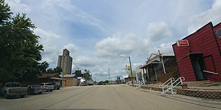
Bogue is a city in Graham County, Kansas, United States. As of the 2020 census, the population of the city was 155. Bogue is located on K-18, south of U.S. Route 24, on the South Fork Solomon River.

<span class="mw-page-title-main">Madison, Kansas</span> City in Greenwood County, Kansas

Madison is a city in Greenwood County, Kansas, United States, along the Verdigris River. As of the 2020 census, the population of the city was 689.

<span class="mw-page-title-main">North Newton, Kansas</span> City in Harvey County, Kansas

North Newton is a city in Harvey County, Kansas, United States. As of the 2020 census, the population of the city was 1,814. It is located between the north side of the city of Newton and the south side of Interstate I-135. North Newton is home of Bethel College.

<span class="mw-page-title-main">Burr Oak, Kansas</span> City in Jewell County, Kansas

Burr Oak is a city in Jewell County, Kansas, United States. As of the 2020 census, the population of the city was 140.

<span class="mw-page-title-main">Randall, Kansas</span> City in Jewell County, Kansas

Randall is a city in Jewell County, Kansas, United States. As of the 2020 census, the population of the city was 79.

<span class="mw-page-title-main">Pleasanton, Kansas</span> City in Kansas, United States

Pleasanton is a city in Linn County, Kansas, United States. As of the 2020 census, the population of the city was 1,208.

<span class="mw-page-title-main">Goff, Kansas</span> City in Nemaha County, Kansas

Goff is a city in Nemaha County, Kansas, United States. As of the 2020 census, the population of the city was 106.

<span class="mw-page-title-main">Earlton, Kansas</span> City in Neosho County, Kansas

Earlton is a city in Neosho County, Kansas, United States. As of the 2020 census, the population of the city was 60.

<span class="mw-page-title-main">Ness City, Kansas</span> City in Ness County, Kansas

Ness City is a city in and the county seat of Ness County, Kansas, United States. As of the 2020 census, the population of the city was 1,329. Ness City is famous for its four-story Old Ness County Bank Building located downtown, and nicknamed Skyscraper of the Plains.

<span class="mw-page-title-main">Ransom, Kansas</span> City in Ness County, Kansas, United States

Ransom is a city in Ness County, Kansas, United States. As of the 2020 census, the population of the city was 260.

<span class="mw-page-title-main">Larned, Kansas</span> City in Pawnee County, Kansas

Larned is a city in and the county seat of Pawnee County, Kansas, United States. As of the 2020 census, the population of the city was 3,769.

<span class="mw-page-title-main">Belvue, Kansas</span> City in Pottawatomie County, Kansas

Belvue is a city in Pottawatomie County, Kansas, United States. As of the 2020 census, the population of the city was 177.

<span class="mw-page-title-main">Plevna, Kansas</span> City in Reno County, Kansas

Plevna is a city in Reno County, Kansas, United States. As of the 2020 census, the population of the city was 85.

<span class="mw-page-title-main">Gaylord, Kansas</span> City in Smith County, Kansas

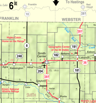
Gaylord is a city in Smith County, Kansas, United States. As of the 2020 census, the population of the city was 87.

References

  1. 1 2 3 4 U.S. Geological Survey Geographic Names Information System: Mayetta, Kansas
  2. "2019 U.S. Gazetteer Files". United States Census Bureau. Retrieved July 24, 2020.
  3. 1 2 "Profile of Mayetta, Kansas in 2020". United States Census Bureau. Archived from the original on June 9, 2022. Retrieved June 8, 2022.
  4. Barr, Elizabeth N. (1907). Business directory and history of Jackson County. p. 70.
  5. Kansas State Historical Society (1916). Biennial Report of the Board of Directors of the Kansas State Historical Society. Kansas State Printing Plant. pp.  207.
  6. Blackmar, Frank Wilson (1912). Kansas: A Cyclopedia of State History, Volume 2. Standard Publishing Company. pp.  249.
  7. "Kansas Post Offices, 1828-1961 (archived)". Kansas Historical Society. Archived from the original on October 9, 2013. Retrieved June 11, 2014.
  8. "US Gazetteer files 2010". United States Census Bureau. Archived from the original on July 2, 2012. Retrieved July 6, 2012.
  9. "US Census Bureau, Table P16: HOUSEHOLD TYPE". data.census.gov. Retrieved January 3, 2024.
  10. 1 2 3 4 5 "US Census Bureau, Table DP1: PROFILE OF GENERAL POPULATION AND HOUSING CHARACTERISTICS". data.census.gov. Retrieved January 3, 2024.
  11. Bureau, US Census. "Gazetteer Files". Census.gov. Retrieved December 30, 2023.
  12. "US Census Bureau, Table P1: RACE". data.census.gov. Retrieved January 3, 2024.
  13. "US Census Bureau, Table P2: HISPANIC OR LATINO, AND NOT HISPANIC OR LATINO BY RACE". data.census.gov. Retrieved January 3, 2024.
  14. "US Census Bureau, Table S1101: HOUSEHOLDS AND FAMILIES". data.census.gov. Retrieved January 3, 2024.
  15. "US Census Bureau, Table S1501: EDUCATIONAL ATTAINMENT". data.census.gov. Retrieved January 3, 2024.
  16. "US Census Bureau, Table S1903: MEDIAN INCOME IN THE PAST 12 MONTHS (IN 2020 INFLATION-ADJUSTED DOLLARS)". data.census.gov. Retrieved January 3, 2024.
  17. "US Census Bureau, Table S2001: EARNINGS IN THE PAST 12 MONTHS (IN 2020 INFLATION-ADJUSTED DOLLARS)". data.census.gov. Retrieved January 3, 2024.
  18. "US Census Bureau, Table S1701: POVERTY STATUS IN THE PAST 12 MONTHS". data.census.gov. Retrieved January 3, 2024.
  19. "US Census Bureau, Table S1702: POVERTY STATUS IN THE PAST 12 MONTHS OF FAMILIES". data.census.gov. Retrieved January 3, 2024.
  20. "U.S. Census website". United States Census Bureau . Retrieved July 6, 2012.
  21. "U.S. Census website". United States Census Bureau . Retrieved January 31, 2008.

Further reading