Related Research Articles

Phoenix is the capital and most populous city of the U.S. state of Arizona, with 1,608,139 residents as of 2020. It is the fifth-most populous city in the United States and the most populous state capital in the country.

Maricopa County is in the south-central part of the U.S. state of Arizona. As of the 2020 census the population was 4,420,568, or about 62% of the state's total, making it the fourth-most populous county in the United States and the most populous county in Arizona, and making Arizona one of the nation's most centralized states. The county seat is Phoenix, the state capital and fifth-most populous city in the United States.
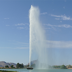
Fountain Hills is a town in Maricopa County, Arizona, United States. Known for its impressive fountain, once the tallest in the world, it borders the Fort McDowell Yavapai Nation, Salt River Pima-Maricopa Indian Community, and Scottsdale. The population was 23,820 as of the 2020 census. Between the 1990 and 2000 censuses it was the eighth-fastest-growing place among cities and towns in Arizona. The median value of an owner-occupied housing during the period 2016-2020 was estimated at $402,100.

Rio Verde is a master-planned community just east of Scottsdale, in Arizona. It is also a census-designated place (CDP) in Maricopa County, Arizona, United States, located in the far, far northeast area of the whole Phoenix Metropolitan Area. The population was 2,210 as of the 2020 census, up from 1,811 at the 2010 census.

Scottsdale is a city in the eastern part of Maricopa County, Arizona, United States, and is part of the Phoenix metropolitan area. Named Scottsdale in 1894 after its founder Winfield Scott, a retired U.S. Army chaplain, the city was incorporated in 1951 with a population of 2,000. At the 2020 census, the population was 241,361, which had grown from 217,385 in 2010. Its slogan is "The West's Most Western Town". Over the past two decades, it has been one of the fastest growing cities in the United States.

The Mojave Desert is a desert in the rain shadow of the southern Sierra Nevada mountains and Transverse Ranges in the Southwestern United States. Named for the indigenous Mohave people, it is located primarily in southeastern California and southwestern Nevada, with small portions extending into Arizona and Utah.

The Sonoran Desert is a hot desert in North America and ecoregion that covers the northwestern Mexican states of Sonora, Baja California, and Baja California Sur, as well as part of the southwestern United States. It is the hottest desert in both Mexico and the United States. It has an area of 260,000 square kilometers (100,000 sq mi).

Angel Island is an island in San Francisco Bay. The entire island is included within Angel Island State Park, administered by California State Parks. The island, a California Historical Landmark, has been used by humans for a variety of purposes, including seasonal hunting and gathering by indigenous peoples, water and timber supply for European ships, ranching by Mexicans, United States military installations, a United States Public Health Service Quarantine Station, and a U.S. Bureau of Immigration inspection and detention facility. The Angel Island Immigration Station, on the northeast corner of the island, which has been designated a National Historic Landmark, was where officials detained, inspected, and examined approximately one million immigrants, who primarily came from Asia. Under the Chinese Exclusion Act of 1882, the first United States law to restrict a group of immigrants based on their race, nationality, and class, all arriving Chinese immigrants were to be examined by immigration or customs agents.
Indio Hills Palms Park Property and the Coachella Valley Preserve, located in the Indio Hills, contain the Thousand Palms Oasis and are a protected area in the Coachella Valley, located east of Palm Springs near Palm Desert, California. The Coachella Valley National Wildlife Refuge is contained within the Coachella Valley Preserve, and all are in the Colorado Desert section of the Sonoran Desert and adjacent to the Lower Colorado River Valley region.
Many of the public parks and parkways system of Buffalo, New York, were originally designed by Frederick Law Olmsted and Calvert Vaux between 1868 and 1896. They were inspired in large part by the parkland, boulevards, and squares of Paris, France. They include the parks, parkways and circles within the Cazenovia Park–South Park System and Delaware Park–Front Park System, both listed on the National Register of Historic Places and maintained by the Buffalo Olmsted Parks Conservancy.

Pinnacle Peak is a granite summit located in Scottsdale, Arizona. The peak rises to an elevation of 3,169 feet (966 m). It is located within the 150-acre (61 ha) Pinnacle Peak Park, operated by the City of Scottsdale Park District. Part of the Sonoran Desert, the park is home to a variety of native desert flora and fauna. Hikers utilize a 1.75 mile trail to explore the area, though rock climbing skills are needed to reach the summit.

The McDowell Mountain Range is located about twenty miles north-east of downtown Phoenix, Arizona, and may be seen from most places throughout the city. The range is composed of miocene deposits left nearly five million years ago. The McDowells share borders with the cities of Fountain Hills, Scottsdale, and Maricopa County. The city of Scottsdale has made its share of the McDowells a preserve, and has set up a wide trail network in partnership with the McDowell Sonoran Conservancy. The McDowell Sonoran Conservancy was established in 1991. The highest peak in the McDowells is East End, at 4,069 feet (1,240 m). This mountain range also serves as a sacred marker to the Yavapai people. The boundaries of the range are generally defined by Saddleback Mountain in the South and Granite Mountain as the Northern boundary. The McDowells also comprise popular landmarks such as Pinnacle Peak and Tom's Thumb. Although technically a stand-alone, Mt. McDowell, not to be confused with McDowell Peak, is sometimes listed on maps as a part of the McDowell Mountains.
The South Mountains are an ancient and deeply eroded mountain range in western North Carolina. They are an isolated remnant of the much larger Appalachian Mountains to the west, and are separated from the Appalachians by the Catawba River valley. The range covers approximately 100,000 acres (400 km²) in Burke, Cleveland, McDowell and Rutherford counties. The South Mountains are the highest and most rugged chain of the isolated mountain ranges which dot North Carolina's Piedmont region. The highest point in the range is Icy knob which rises to 3,000 feet above sea level. The South Mountains are heavily forested with Southeastern mixed forests. Water erosion from numerous rivers and streams has given the mountains narrow ridges and valleys.
East End is a mountain located at the northeastern end of the McDowell Mountains and about 24 miles (39 km) north northeast of Scottsdale, Arizona. Its summit is the highest point in the range, at 4,069 feet (1,240 m). The mountain is mostly covered in rocky boulders, and is the site of the ancient Marcus Landslide.
McDowell Peak is located in the McDowell Mountains, to the northeast of Phoenix, Arizona. Its height is 4,036 feet (1,230 m). McDowell Peak is located approximately half a mile north of the easily recognizable Thompson Peak, and shares a ridge with Drinkwater Peak. It is bordered on the south by Bell Pass, and on the north by Windgate Pass.
The Phoenix Mountains Preserve is a group of parks located among the Phoenix Mountains in Phoenix, Arizona, United States. The Phoenix Mountains Park and Recreation Area, the first of these parks to be preserved, has been designated as a Phoenix Point of Pride.
The McDowell Sonoran Conservancy is an independent non-profit 501(c)(3) conservation organization. Its published mission is to “champion the sustainability of the McDowell Sonoran Preserve for the benefit of this and future generations. As stewards, we connect the community to the Preserve through education, research, advocacy, partnerships and safe, respectful access.” The McDowell Sonoran Preserve is the largest urban preserve in the U.S., located within the city limits of Scottsdale, Arizona. It encompasses more than 30,580-acre (12,380 ha) of upper Sonoran Desert, including large portions of the McDowell Mountains.
The Wildlands Conservancy (TWC) is a nonprofit organization whose mission is to preserve land for public recreation. It operates 25 preserves containing over 200,000 acres (81,000 ha) in the western United States. The preserve system includes a variety of scenery including mountains, valleys, deserts, rivers and oceanfront lands. TWC buys land, restores land, builds public visitor facilities and provides outdoor education programs for children. All usage is free of charge. There are over 1.5 million visitors annually.

Sand to Snow National Monument is a U.S. National Monument located in San Bernardino County and northern Riverside County, Southern California.
The Wilderness Gateway State Trail is a unit of the North Carolina state park system in Burke, Catawba, McDowell and Rutherford Counties, North Carolina in the United States. The State Trail is planned as a hiking trail connecting the Town of Valdese, the City of Hickory, the Overmountain Victory National Historic Trail, South Mountains State Park and Chimney Rock State Park The trail is a collaboration between local governments and the state, with development coordinated by the North Carolina Division of Parks and Recreation (NCDPR).
References
- ↑ "City of Scottsdale – McDowell Sonoran Preserve". City of Scottsdale. Retrieved 2016-11-14.
- ↑ "The Largest City Parks in the United States". World Atlas. Retrieved 2023-03-23.
- ↑ "Homepage". McDowell Sonoran Conservancy. Retrieved 2016-11-14.
| International | |
|---|---|
| National | |