Meadowbrook, Queensland

Last updated

Map all coordinates using: OpenStreetMap
Meadowbrook
Logan City,  Queensland
Edeanlea Drive Meadowbrook.jpg
Edeanlea Drive, 2013
Australia Queensland location map.svg
Red pog.svg
Meadowbrook
Coordinates 27°39′56″S153°08′37″E / 27.6655°S 153.1436°E / -27.6655; 153.1436 (Meadowbrook (centre of suburb))
Population3,113 (2016 census) [1]
 • Density546/km2 (1,414/sq mi)
Established1991
Postcode(s) 4131
Elevation13 m (43 ft)
Area5.7 km2 (2.2 sq mi)
Time zone AEST (UTC+10:00)
Location
LGA(s) Logan City
State electorate(s) Waterford
Federal division(s)
Suburbs around Meadowbrook:
Kingston Slacks Creek Slacks Creek
Kingston Meadowbrook Tanah Merah
Loganlea Loganlea Bethania

Meadowbrook is a mixed-use suburb in the City of Logan, Queensland, Australia. [2] In the 2016 census, Meadowbrook had a population of 3,113 people. [1] The Logan Hospital and a TAFE college are located in the suburb.

Contents

Geography

The northern and eastern border of the suburb follow Logan River and part of its tributary Slacks Creek.The Gold Coast railway line marks the southern boundary.

The Loganlea Golf Course and Logan campus of Griffith University are located in Meadowbrook. Most of the golf course is within a defined flood zone as is Lake Elleslie at the entrance to the university. Logan Hospital is located in Armstrong Road ( 27°40′11″S153°08′26″E / 27.6698°S 153.1406°E / -27.6698; 153.1406 (Logan Hospital) ). There is also an industrial area in the west of Meadowbrook and a large section of housing surround the hospital and adjacent TAFE college. Meadowbrook is home to Riverdale Park, a former grazing property. [3] Waterways of Slacks Creek dominate the northern sections of Meadowbrook with suburban arterial Loganlea Road heading towards the Pacific Motorway and Slacks Creek being the only road in the area. Power lines and an electrical substation have been built in the industrial area.

Riverdale Park

Riverdale Park, 2013 Riverdale Park Meadowbrook.jpg
Riverdale Park, 2013

A long section of the Logan River stretching past Meadowbrook was once grazing lands. Farms provided milk for the nearby Kingston Butter Factory. Today the flood prone area has been converted into a well-catered 10-hectare parklands. The park's entrance is in Armstrong Street. Cemented walking paths extend up Slacks Creek towards the Logan Motorway and Tanah Merah. There are two dog-off-leash sections, facilities for large groups, playground and exercise equipment.

History

Main entrance, 2013 Logan Hospital entrance.jpg
Main entrance, 2013

The Logan Hospital was opened in 1990. Due to growth in the area the hospital has undergone several upgrades.

The suburb was formed in 1991 as a subdivision of Loganlea. [4]

The Logan campus for Griffith University and TAFE college opened in 1998. [5]

A master plan for the suburb was being prepared by the Logan City Council in 2013. [6] The master plan was finalised in 2016. [7] It focused on health, education and wellbeing. [7] Meadowbrook was designated as a Specialist Centre in the South East Queensland Regional Plan 2009–2031, dedicated to health, research and education. [8]

Demographics

In the 2011 census, Meadowbrook recorded a population of 3,138 people, 51.1% female and 48.9% male. [9] The median age of the Meadowbrook population was 31 years, 6 years below the national median of 37. 61% of people living in Meadowbrook were born in Australia. The other top responses for country of birth were New Zealand 10.1%, England 4.8%, Philippines 1.8%, Fiji 1.1%, Malaysia 1%. 76.3% of people spoke only English at home; the next most common languages were 1.5% Hindi, 1.3% Mandarin, 1.2% Cantonese, 1.2% Vietnamese, 1.1% Tagalog. [9]

In the 2016 census, Meadowbrook had a population of 3,113 people. [1]

Transport

The suburb is crossed by a number of major transport routes. These include the Logan Motorway, Loganlea railway station for both the Beenleigh railway line and Gold Coast railway line and Loganlea Road. The suburb is serviced by the 560 and 562 Translink bus services linking the suburb to Logan Central, Springwood, Browns Plains and the Logan Hyperdome. A number of bus routes services Meadowbrook and there are two established bikeways.

Problems with illegal car parking in the streets around the hospital, TAFE and train station were addressed with increased restriction of two-hour limited parking. [10]

Education

There are no schools in Meadowbrook. The nearest primary schools are Daisy Hill State School to the north in Daisy Hill and Waterford West State School to the south-west in Waterford West. [11] The nearest secondary school is Loganlea State High School to the south in neighbouring Loganlea. [11]

The Loganlea campus of TAFE College is at Armstrong Road ( 27°40′17″S153°08′41″E / 27.6713°S 153.1448°E / -27.6713; 153.1448 (TAFE Queensland Loganlea campus) ). [11]

The Logan campus of Griffith University is at University Drive ( 27°39′52″S153°09′07″E / 27.6644°S 153.1520°E / -27.6644; 153.1520 (Griffith University Logan campus) ). [11]

Related Research Articles

<span class="mw-page-title-main">Logan City</span> City in Queensland, Australia

The City of Logan is a local government area situated within the south of the Brisbane metropolitan area in South East Queensland, Australia. Situated between the City of Brisbane to the north and the City of Gold Coast to the south, the City also borders the Scenic Rim Region, the City of Ipswich, and Redland City LGAs. Logan City is divided into 70 suburbs and 12 divisions; a councillor is elected to each of the latter. The council had a population of 326,615 in June 2018.

<span class="mw-page-title-main">Loganlea railway station</span> Railway station in Queensland, Australia

Loganlea railway station is located on the Beenleigh line in Queensland, Australia. It serves the suburbs of Loganlea and Meadowbrook in Logan City. The station opened in 1885 at the same time as the line. On 21 April 1992, a second platform opened as part of the duplication of the line. It is within a short distance of the Logan Hospital, TAFE college, Griffith University Logan campus, Loganlea State High School and Woolworths supermarket.

<span class="mw-page-title-main">Mount Gravatt, Queensland</span> Suburb of Brisbane, Queensland, Australia

Mount Gravatt is a southern suburb of the City of Brisbane, Queensland, Australia and a prominent hill and lookout within this suburb. In the 2016 census, Mount Gravatt had a population of 3,366 people.

<span class="mw-page-title-main">Eight Mile Plains, Queensland</span> Suburb of Brisbane, Queensland, Australia

Eight Mile Plains is an outer southern suburb in the City of Brisbane, Queensland, Australia. In the 2016 census, Eight Mile Plains had a population of 15,322 people.

<span class="mw-page-title-main">Greenslopes, Queensland</span> Suburb of Brisbane, Queensland, Australia

Greenslopes is a suburb in the City of Brisbane, Queensland, Australia. In the 2021 census, Greenslopes had a population of 7,941 people.

<span class="mw-page-title-main">Browns Plains, Queensland</span> Suburb of Logan City, Queensland, Australia

Browns Plains is a suburb in the City of Logan, Queensland, Australia. In the 2021 census, Browns Plains had a population of 6,632 people.

<span class="mw-page-title-main">Berrinba, Queensland</span> Suburb of Logan City, Queensland, Australia

Berrinba is a suburb in Logan City, Queensland, Australia. In the 2016 census, Berrinba had a population of 1,345 people.

<span class="mw-page-title-main">Daisy Hill, Queensland</span> Suburb of Logan City, Queensland, Australia

Daisy Hill is a suburb in the City of Logan, Queensland, Australia. In the 2016 census, Daisy Hill had a population of 6,660 people.

<span class="mw-page-title-main">Kingston, Queensland</span> Suburb of Logan City, Queensland, Australia

Kingston is a town and suburb in the City of Logan, Queensland, Australia. In the 2016 census, Kingston had a population of 10,539 people.

<span class="mw-page-title-main">Loganholme, Queensland</span> Suburb of Logan City, Queensland, Australia

Loganholme is a suburb in the City of Logan, Queensland, Australia. In the 2016 census, Loganholme had a population of 6,303 people.

<span class="mw-page-title-main">Loganlea, Queensland</span> Suburb of Logan City, Queensland, Australia

Loganlea is a suburb in the City of Logan, Queensland, Australia. In the 2016 census, Loganlea had a population of 7,321 people.

<span class="mw-page-title-main">Shailer Park, Queensland</span> Suburb of City of Logan, Queensland, Australia

Shailer Park is a suburb in the City of Logan, Queensland, Australia. In the 2016 census, Shailer Park had a population of 11,759 people.

<span class="mw-page-title-main">Springwood, Queensland</span> Suburb of Logan City, Queensland, Australia

Springwood is a suburb in the City of Logan, Queensland, Australia. In the 2021 census, Springwood had a population of 9,710 people.

<span class="mw-page-title-main">Tanah Merah, Queensland</span> Suburb of Logan City, Queensland, Australia

Tanah Merah is a residential suburb in the City of Logan, Queensland, Australia. In the 2016 census, Tanah Merah had a population of 4,752 people. It was originally named by the Queensland Place Names Board in 1971.

Pimpama is a northern suburb in the City of Gold Coast, Queensland, Australia. At the 2021 census, Pimpama had a population of 24,601. The name is of Aboriginal origin. The suburb contains numerous schools with the first opening in the 1870s.

<span class="mw-page-title-main">Slacks Creek, Queensland</span> Suburb of Logan City, Queensland, Australia

Slacks Creek is a suburb in the City of Logan, Queensland, Australia. In the 2016 census, Slacks Creek had a population of 10,432 people.

<span class="mw-page-title-main">Electoral district of Waterford</span> State electoral district of Queensland, Australia

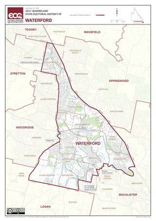
Waterford is an electoral district of the Legislative Assembly in the Australian state of Queensland.

<span class="mw-page-title-main">Coomera, Queensland</span> Town in Queensland, Australia

Coomera is a town and suburb in the City of Gold Coast, Queensland, Australia. In the 2016 census, Coomera had a population of 13,305 people.

<span class="mw-page-title-main">Waterford, Queensland</span> Town in Queensland, Australia

Waterford is a town and suburb in the City of Logan, Queensland, Australia. In the 2016 census, the suburb of Waterford had a population of 5,484 people.

<span class="mw-page-title-main">Logan Hospital</span> Hospital in Queensland, Australia

Logan Hospital is the major health centre servicing the Logan region in the state of Queensland and provides a range of speciality services for children and adults. Located at the corner of Armstrong and Loganlea Roads in Meadowbrook, Queensland, Australia.

References

  1. 1 2 3 Australian Bureau of Statistics (27 June 2017). "Meadowbrook (SSC)". 2016 Census QuickStats. Retrieved 20 October 2018. OOjs UI icon edit-ltr-progressive.svg
  2. "Meadowbrook – suburb in City of Logan (entry 45278)". Queensland Place Names. Queensland Government . Retrieved 26 January 2020.
  3. "Riverdale Park". Parks Directory. Logan City Council. Retrieved 21 December 2013.
  4. "Meadowbrook". Queensland Places. Centre for the Government of Queensland, University of Queensland.
  5. Howells, Mary. Logan Regional History (PDF). Logan City Council. pp. 98–99. Retrieved 21 December 2013.
  6. "Meadowbrook". Structure Plans and Master Plans. Logan City Council. Archived from the original on 24 December 2013. Retrieved 21 December 2013.
  7. 1 2 "Place-based projects: Meadowbrook". Logan City Council. Retrieved 23 October 2021.
  8. "Structure Plans & Master Plans". Logan City Council. Archived from the original on 5 February 2014. Retrieved 22 December 2013.
  9. 1 2 Australian Bureau of Statistics (31 October 2012). "Meadowbrook (State Suburb)". 2011 Census QuickStats. Retrieved 20 December 2013. OOjs UI icon edit-ltr-progressive.svg
  10. Heidi Braithwaite (10 May 2013). "Park restrictions around major Meadowbrook facilities will improve safety following an abundance of fines". couriermail.com.au. News Ltd. Retrieved 21 December 2013.
  11. 1 2 3 4 "Queensland Globe". State of Queensland . Retrieved 1 April 2020.