Related Research Articles

The Metauro is a river in the Marche region of central Italy. It rises in the Apennine Mountains and runs east for 110 kilometres (68 mi) or 121 kilometres (75 mi) if the Meta is included as its uppermost reach.
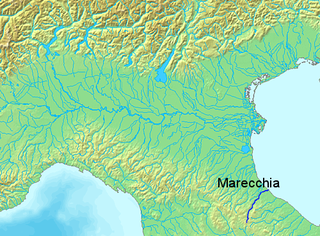
The Marecchia is a river in eastern Italy. In ancient times it was known as the Ariminus which was from the Greek Aríminos. The source of the river is near Monte dei Frati which is east of Pieve Santo Stefano and southwest of Badia Tedalda in the Province of Arezzo in Tuscany. It flows northeast into the Province of Pesaro and Urbino in the Marche and is the only river that runs through Montefeltro. While flowing through Montefeltro, the river flows through the exclave Santa Sofia Marecchia, which belongs to Badia Tedalda. The river then flows past Sant'Agata Feltria and Novafeltria before crossing into the Province of Rimini in Emilia–Romagna. At Torello, part of the commune of San Leo, it flows 1 km west of the Sammarinese territory Acquaviva and the San Marino River flows into it, but the Marecchia does not touch the San Marino border. Finally, the river flows past Verucchio and Santarcangelo di Romagna before flowing into the Adriatic Sea near Rimini.

The Ofanto, known in ancient times as Aufidus or Canna, is a 134 or 170 km river in southern Italy that flows through the regions of Campania, Basilicata, and Apulia, into the Gulf of Manfredonia near Barletta.
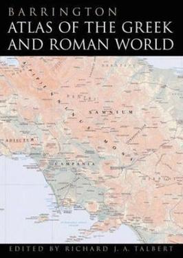
The Barrington Atlas of the Greek and Roman World is a large-format English language atlas of ancient Europe, Asia, and North Africa, edited by Richard J. A. Talbert. The time period depicted is roughly from archaic Greek civilization through Late Antiquity. The atlas was published by Princeton University Press in 2000. The book was the winner of the 2000 Association of American Publishers Award for Best Professional/Scholarly Multivolume Reference Work in the Humanities.

Melito Irpino is a town and comune in the province of Avellino, in the Campania region of south-western Italy.

The Tronto is a 115-kilometre (71 mi) long Italian river that arises at Monti della Laga and ends in the Adriatic Sea at Porto d'Ascoli, San Benedetto del Tronto. It traverses the Lazio, Marche, and Abruzzo regions of Italy.

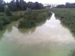
The Foglia is the northernmost river of the Marche region of Italy. In ancient times it was known as Pisaurus, as it debouched into the Adriatic Sea at Pisaurum. It was also known as the Isaurus. The source of the river is west of Sestino in the province of Arezzo in the Umbrian-Marchean Apennines mountains. It flows east through an extension of the province of Pesaro e Urbino and then back into Arezzo before forming the border between Arezzo and Pesaro e Urbino. The river then flows into the province of Pesaro e Urbino past Piandimeleto and curves northeast and flows past Sassocorvaro before curving east again. The river meanders south of Montecalvo in Foglia before curving northeast and flowing near Colbordolo, Saludecio, Sant'Angelo in Lizzola, Montecchio, Montelabbate and Tavullia before entering the Adriatic Sea near Pesaro.

The Vomano is a 76 km river, which is in the Abruzzo region of Italy. Its source is near Monte San Franco in Gran Sasso d'Italia and Lago di Campotosto in the province of L'Aquila. The river crosses the border into the province of Teramo and flows northeast near Montorio al Vomano and Basciano. The Fucino flows into the Vomano south of Crognaleto and the Mavone flows into the Vomano near Basciano. It enters the Adriatic Sea near Roseto degli Abruzzi.

The Esino is a river in the Marche region of central Italy.
La Verde is an Italian river whose source is on Montalto in the Aspromonte National Park, in Calabria, southern Italy. From there, the river flows southeast and then flows east before emptying into the Ionian Sea north of Cape Bruzzano. It has a drainage basin of 117 square kilometres (45 sq mi).
The Misa is a river in the Marche region of Italy. It runs for over 48 kilometres through the region. The source of the river lies south of Arcevia in the province of Ancona. The river flows northeast near Serra de' Conti, Ostra Vetere and Ostra. The river is joined by the Nevola before entering the Adriatic Sea near Senigallia.

The Musone is a river in the Marche region of Italy. The source of the river is east of Matelica and south of Monte San Vicino in the province of Macerata. The river flows northeast near Apiro, Cingoli and Staffolo before crossing into the province of Ancona near Filottrano. The river then flows southeast and is joined by a tributary south of Osimo before curving northeast near Loreto. Finally, the river empties into the Adriatic Sea north of Porto Recanati and south of Numana.

The Ausa or Aussa is a river in the Italian province of Udine. Its source is near the city of Udine. The river flows south past Palmanova, Aiello del Friuli, Cervignano del Friuli and Terzo d'Aquileia before emptying into the Laguna di Marano between Marano Lagunare and Aquileia.
The Livenza is a river in the Italian provinces of Pordenone, Treviso and Venice. Its source is near Polcenigo and Caneva in Pordenone. It flows in a southeasterly direction past Sacile and forms the border between the provinces of Pordenone and Treviso roughly between Brugnera and Motta di Livenza. It continues to flow in a southeasterly direction, forming the border between the provinces of Treviso and Venice before flowing into the province of Venice near Santo Stino di Livenza. It flows near La Salute di Livenza and finally enters the Adriatic Sea near Caorle.
The Salinello is a river in Italy. It is located in the province of Teramo in the Abruzzo region of southern Italy. The source of the river is in the Monti della Laga range southwest of Montagna dei Fiori. The river flows eastward and curves northeast near Civitella del Tronto. The river then curves southeast near Sant'Egidio alla Vibrata and the border with the province of Ascoli Piceno. Finally, the river flows east near Sant'Omero and enters the Adriatic Sea near Giulianova and Tortoreto Lido.

The Neto is a river in Calabria, southern Italy. It is the second largest river of Calabria after the Crati.

The Gulf of Saint Euphemia is a gulf on the west coast of Calabria, southern Italy. It is part of the Tyrrhenian Sea and borders the province of Cosenza, the province of Catanzaro, and the province of Vibo Valentia.

The Esaro is a river in the province of Crotone, Calabria, southern Italy. Its source is near Cutro. The river flows southeast near Crotone Airport before curving northeast and eventually flowing into the Ionian Sea just north of Crotone.
Choiragria was a town of ancient Thrace, inhabited during Roman times.

Hermocapelia or Hermokapeleia, also possibly known as Thyessos, was a town of ancient Lydia. It was inhabited from Classical through Byzantine times. It stood on the Hermus River, "to the west of Apollonis in its own little plain almost completely surrounded by mountains."
References
- ↑ Richard J.A. Talbert, ed. (2000). Barrington Atlas of the Greek and Roman World: Map-By-Map Directory. Vol. I. Princeton, NJ and Oxford, UK: Princeton University Press. p. 698. ISBN 0691049459.
- ↑ The Times (2003), Comprehensive Atlas of the World Eleventh Edition, Times Books, Plate 78 (J8).
| | This Calabrian location article is a stub. You can help Wikipedia by expanding it. |