Metropolitan Corporation of Greater Winnipeg

Last updated
Metropolitan Corporation of Greater Winnipeg
Metropolitan government overview
FormedJanuary 1, 1961;61 years ago (January 1, 1961)
DissolvedDecember 31, 1971;50 years ago (December 31, 1971)
JurisdictionGreater Winnipeg
Headquarters100 Main St.
Winnipeg, Manitoba
49°53′16.3″N97°08′5.8″W / 49.887861°N 97.134944°W / 49.887861; -97.134944 Coordinates: 49°53′16.3″N97°08′5.8″W / 49.887861°N 97.134944°W / 49.887861; -97.134944

Metropolitan Corporation of Greater Winnipeg was a governing body that served as part of the leadership for the metropolitan area of Winnipeg. It was established by Premier Douglas Campbell after he was given a commission to do so by the Greater Winnipeg Investigating Commission. It was dissolved when its component municipalities were amalgamated into one "unicity" in 1972. Winnipeg is a city in Manitoba, Canada.

Contents

History

In August 1955 the Greater Winnipeg Investigating Commission was appointed by Premier Douglas Campbell to design and recommend a metropolitan level of governance for the Greater Winnipeg area. [1] Commission members included Mayor George Sharpe of Winnipeg, Mayor J. G. Belleghem of St. Boniface, Mayor Thomas Findlay of St. James, Councillor C. N. Kushner of West Kildonan, and J. L. Bodie, former Mayor of East Kildonan. Their report was released at the end of March 1959. [2]

When implemented, it was the third form of metropolitan government instituted on the North American continent after Toronto (1954) and Dade County, Florida (1957). [3] [4]

The original name for the governing entity would have been The Corporation of Metropolitan Winnipeg. However the Mayors did not like this name and had it changed in March 1960 to the Metropolitan Corporation of Greater Winnipeg. [5]

In 1960, the Metropolitan Corporation of Greater Winnipeg was established by Manitoba's Metropolitan Winnipeg Act as a separate layer of municipal government in the metropolitan area of Winnipeg, Manitoba. Bill 62 entered Second Reading stage in February 1960. [6]

Metro Winnipeg consisted of the City of Winnipeg and various surrounding municipalities, including Brooklands, Tuxedo, Charleswood, Transcona, West Kildonan, North Kildonan, East Kildonan, Old Kildonan, Saint Boniface, Saint Vital and Fort Garry. During the period of its existence, it provided services such as transit, parks, water and other municipal services to residents. [7]

Bonnycastle Park commemorating Metro's first Chairman. Bonnycastle Park Plaque.jpg
Bonnycastle Park commemorating Metro's first Chairman.

Metro government was established in November 1960 and absorbed the Greater Winnipeg Transit Commission on Jan. 1, 1961. During this time it operated under a Committees Council system, with six divisions reporting to an executive director. It ceased to exist upon the introduction of a unified municipal government (popularly known as "Unicity") by the Province of Manitoba under Premier Ed Schreyer, effective Jan. 1, 1972.

The administration offices were located at 100 Main Street. The building was the administrative headquarters of the City of Winnipeg Streets & Transportation Department until 2007-2008 when the city handed it over to the Friends of Upper Fort Garry to make way for an expanded Upper Fort Garry Heritage park.

On January 1, 1972 Metro was dissolved in favour of combining all municipalities under one city. All former City, RM, and Town Acts were repealed. [8]

Responsibilities

Metro's responsibilities included:

Planning for all major thoroughfares and bridge crossings. Operation of major and emerging parks over 15 acres (6.1 ha) in size: [4] Assiniboine Park, Kildonan Park, St. Vital Park, Crescent Drive Park. [9] Property assessment. Provision of water, sewage, garbage, and public transit services to metro area municipalities.

Legacy

Metro Winnipeg attempted to introduce a co-ordinated approach planning between its member municipalities, and to that end it created several planning documents. Those documents included the Downtown Winnipeg Plan, the Winnipeg Area Transportation Study, and District Area Plans for the suburban municipalities of metropolitan Winnipeg. Metro Winnipeg was responsible for the operation of Metro Winnipeg Transit.

Metro was involved in the initial plans for the Winnipeg Convention Centre. [10] Under Metro the Transit garage on Assiniboine Avenue was closed. A new and larger Metro Transit Base on Osborne St. was opened in 1969.

The route numbering system in place today was originally introduced as the Metro Route system. [11] Testing went on during the 1960s, with final sign design and route numbering plan completed in July 1967 weeks before the start of the Pan Am Games. [12]

See also

Related Research Articles

<span class="mw-page-title-main">Winnipeg</span> Capital city of Manitoba, Canada

Winnipeg is the capital and largest city of the province of Manitoba in Canada. It is centred on the confluence of the Red and Assiniboine rivers, near the longitudinal centre of North America. As of 2021, Winnipeg had a city population of 749,607 and a metropolitan population of 834,678, making it the sixth-largest city, and eighth-largest metropolitan area in Canada.

The Winnipeg City Council is the governing body of the city of Winnipeg, Manitoba, Canada. The Council is seated in the Council Building of Winnipeg City Hall.

Winnipeg Metropolitan Region Metropolitan area in Manitoba, Canada

The Winnipeg Metropolitan Region is a metropolitan area in the Canadian province of Manitoba located in the Red River Valley in the southeast portion of the province of Manitoba, Canada. It contains the provincial capital of Winnipeg and 17 surrounding rural municipalities, cities, and towns.

East Kildonan, Winnipeg Suburban community in southeast Manitoba.

East Kildonan is a primarily residential community in northeast Winnipeg, Manitoba, Canada. Commonly known by its initials EK, the suburb has a population of approximately 35,800 as of the 2016 Census.

Tuxedo, Winnipeg Suburb of Winnipeg, Canada

Tuxedo is a residential suburb of Winnipeg, Manitoba. Prior to 1972, the community was incorporated as the Town of Tuxedo. Today, it is the wealthiest area of Winnipeg, with the highest property values.

Old Kildonan is the northernmost city ward of Winnipeg, Manitoba. Before the City of Winnipeg Act of 1972, it was an independent unincorporated municipality called the Municipality of Old Kildonan; prior to that, from 1914, it was a subdivision of the Rural Municipality of Kildonan.

St. Vital is a ward and neighbourhood of Winnipeg, Manitoba, Canada.

Amalgamation of Winnipeg Merger of the City of Winnipeg with other municipalities in 1972

The amalgamation of Winnipeg, Manitoba, was the municipal incorporation of the old City of Winnipeg, 11 surrounding municipalities, and the Metropolitan Corporation of Greater Winnipeg (Metro) into a one Unified City of Winnipeg, or Unicity.

Kildonan Park Regional park in West Kildonan (Winnipeg), Canada

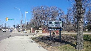
Kildonan Park is a park in the West Kildonan area of northern Winnipeg, Manitoba, Canada.

St. James-Assiniboia, Winnipeg Suburb in Winnipeg, Manitoba, Canada

St. James-Assiniboia is a major community area in Winnipeg, Manitoba, Canada. As it encapsulates most of the city ward of St. James, which includes the major St. James Street, the area itself is often simply referred to "St. James."

<span class="mw-page-title-main">Winnipeg Transit</span> Public Bus Agency owned by the City of Winnipeg

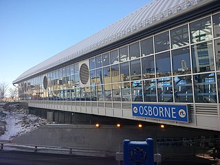
Winnipeg Transit is the public transit agency, and the bus-service provider, of the City of Winnipeg, Manitoba. Established 139 years ago, it is owned by the city government and currently employs nearly 1,600 people—including approximately 1,100 bus drivers.

<span class="mw-page-title-main">Transport in Winnipeg</span>

Transport in Winnipeg involves various transportation systems, including both private and public services, and modes of transport in the capital city of Manitoba.

Wildwood Park is a suburban, planned community in Winnipeg that has a central green space and no front roads, with communal walkways, playgrounds, and parks.

Route 52 is a major north-south arterial route in Winnipeg, Manitoba, Canada. It comprises all of Main Street, Queen Elizabeth Way, and St. Mary's Road.

History of Winnipeg

The history of Winnipeg comprises its initial population by Aboriginal peoples through its settlement by Europeans to the present day. The first forts were built on the future site of Winnipeg in the 1700s, followed by the Selkirk Settlement in 1812. Winnipeg was incorporated as a city in 1873 and experienced dramatic growth in the late 19th and early 20th centuries. Following the end of World War I, the city's importance as a commercial centre in Western Canada began to wane. Winnipeg and its suburbs experienced significant population growth after 1945, and the current City of Winnipeg was created by the unicity amalgamation in 1972.

Winnipeg, Manitoba, is subdivided in different ways for different purposes. The suburbs and neighbourhoods of Winnipeg take their names from former administrative districts, parishes, and geographic features.

Winnipeg RT Winnipeg Rapid Transit

Winnipeg RT is a bus rapid transit system of Winnipeg Transit in Winnipeg, Manitoba, Canada, currently consisting of the Southwest Transitway. Future expansions are in the planning stages, consisting of an Eastern Corridor connecting downtown to Transcona and a West-North Corridor connecting St. James with Downtown and West Kildonan.

Greater Winnipeg Water District Aqueduct

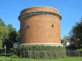
The Greater Winnipeg Water District Aqueduct supplies the city of Winnipeg, Manitoba with water from Shoal Lake in the Kenora District of Ontario. It was put in service in 1919 and cost nearly CDN $16 million. It has a capacity of 85 million Imperial gallons per day and extends approximately 96 miles (154 km) from an intake structures on Shoal Lake to the Deacon Reservoir on the east side of the city. Water flows by gravity from the lake, since the aqueduct drops about 300 feet (91 m) over its length. The Greater Winnipeg Water District Railway was built for construction and maintenance of the aqueduct. The capacity was planned for a city of one million inhabitants; peak water usage by the city was in 1988 and the capacity of the aqueduct has never been entirely used. An additional 12 miles (19 km) branch was completed in 1960.

Broadway is a street in the city of Winnipeg, Manitoba, Canada. It is one of the city's oldest and most historic routes and forms the Trans-Canada Highway route through the city's downtown.

References

  1. "Probers Can Draft Metro Law: Powers Outlined In City Merger". The Winnipeg Tribune. August 25, 1955. p. 19.
  2. "Metro System Had Roots In Oldtime Discussions". The Winnipeg Tribune. March 31, 1959. p. 4.
  3. "Zoning, Building Planning Said Metro's Biggest Job". The Winnipeg Tribune. February 27, 1961. p. 15.
  4. 1 2 Ostrander, L. E. (February 24, 1961). "Planning For Metro". The Winnipeg Chamber of Commerce. Archived from the original on August 8, 2011.
  5. "He Wants A Greater Metro Label". The Winnipeg Tribune. March 17, 1960. p. 21.
  6. Desberats, Peter (February 17, 1960). "The Metro Plan: This Is It". The Winnipeg Tribune. pp. 1, 14.
  7. "City of Winnipeg Archives".
  8. McMonagle, Duncan (December 31, 1971). "Controversial Metro Gives New City Transportation Study, Development Plan". Winnipeg Free Press. p. 16.
  9. "Some Interesting Facts About Your Metro Parks' System". Metropolitan Corporation of Greater Winnipeg. March 1971. Archived from the original on August 8, 2011.
  10. "$35 Million Convention Centre Set: Provincial-Metro Project". Winnipeg Free Press. September 10, 1970. p. 81.
  11. "Route Signs Tested: Metro Experiment Prompts Motorist Complaints". Winnipeg Free Press. March 5, 1964. p. 3.
  12. "Visitors Can Play Numbers Game". Winnipeg Free Press. July 19, 1967. p. 47.