Federal Highway 40, also called the Carretera Interoceánica, is a road beginning at Reynosa, Tamaulipas, just west of the Port of Brownsville, Texas, and ending at Fed. 15 in Villa Unión, Sinaloa, near Mazatlán and the Pacific coast. It is called Interoceanic as, once finished, the cities of Matamoros, Tamaulipas, on the Gulf of Mexico and Mazatlán on the Pacific Ocean will be linked.

Federal Highway 15 is Mexico 15 International Highway or Mexico-Nogales Highway, is a primary north–south highway, and is a free part of the federal highways corridors of Mexico. The highway begins in the north at the Mexico–United States border at the Nogales Port of Entry in Nogales, Sonora, and terminates to the south in Mexico City.
Federal Highway 2 is a free part of the Mexican federal highway corridors that runs along the U.S. border. The highway is in two separate improved segments, starting in the west at Tijuana, Baja California, on the Pacific coast and ending in the east in Matamoros, Tamaulipas, on the Gulf of Mexico. Fed. 2 passes through the border states of Baja California, Sonora, Chihuahua, Coahuila, Nuevo Leon and Tamaulipas. It has a total length of 1,987 kilometres (1,235 mi); 1,343 kilometres (835 mi) in the west and 644 kilometres (400 mi) in the east.

As the third largest and second most populous country in Latin America, Mexico has developed an extensive transportation network to meet the needs of the economy. As with communications, transportation in Mexico is regulated by the Secretariat of Communications and Transportation, a federal executive cabinet branch.
Federal Highway 1D is a tolled part of the Mexico Federal Highways, paralleling Fed. 1. There are two segments, one in the state of Baja California and another in the state of Baja California Sur.
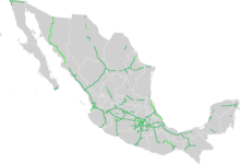
Federal Highway 54 Fed. 54 is a free (libre) part of the federal highways corridors and connects Ciudad Mier, Tamaulipas, to Colima City.
Federal Highway 14 is a free part of the federal highways corridors of Mexico.
Federal Highway 87 is a highway in Mexico. The highways starts in the north in Tula de Allende, Hidalgo (state) at the Libramiento de Tula. The highway runs easterly approximately 3.25 kilometres (2.02 mi) then it turns south to end in Jorobas, Huehuetoca, State of Mexico, at Fed. 57D toll road. The total length of Fed. 87 is 37.7 kilometres (23.4 mi).
Federal Highway 37 is a free part of the federal highways corridors of Mexico. The highway runs from Villa de Zaragoza, San Luis Potosí at its northern point to Playa Azul, Michoacán, located near the Pacific Ocean, at its southern point, near the port city of Lázaro Cárdenas, Michoacán. It crosses Fed. 14 at Uruapan, Michoacán, and Mexican Federal Highway 200 at La Mira, Michoacan.
Federal Highway 43 (Fed. 43) is a free (libre) part of the federal highways corridors of Mexico.
Federal Highway 51 (Fed. 51) is a free (libre) part of the federal highways corridors of Mexico. Fed. 51 has two segments: the first segment run from Ojuelos de Jalisco to Maravatío, Michoacán. The length of the first segment is 309.41 km. The second segment runs from Zitácuaro, Michoacán to Iguala, Guerrero. The length of the second segment is 399.05 km.
Federal Highway 57 (Fed. 57) is a free (libre) part of the federal highways corridors of Mexico.
Federal Highway 126 is a free (libre) part of the federal highways corridors of Mexico. The highway runs from Morelia, Michoacán in the west to El Oro de Hidalgo, State of Mexico in the east. The eastern portion of the highway continues on to Atlacomulco as Fed. 5. The two nearest federal highways to the western and eastern termini of Fed. 126 are Fed. 55 in Atlacomulco and Fed. 15 in Morelia.
Federal Highway 295 is a toll-free part of the federal highway corridors of Mexico.
Federal Highway 11 is a toll-free part of the federal highway corridors. Fed. 11 runs from Fed. 1 in La Paz, Baja California Sur to Pichilingue, a total length of 18 km (11.18 mi).
Federal Highway 15D is the name for toll highways paralleling Federal Highway 15. The toll segments of Highway 15D include some of the most significant highways in the country along the Nogales-Mexico City corridor. The highway is the southern terminus of the CANAMEX Corridor, a trade corridor that stretches from Mexico north across the United States to the Canadian province of Alberta.
Federal Highway 2D is a part of the federal highways corridors, and is the designation for toll highways paralleling Mexican Federal Highway 2. Seven road segments are designated Highway 2D, all but one in the state of Baja California, providing a toll highway stretching from Tijuana in the west to around Mexicali in the east; one in Sonora, between Santa Ana and Altar; and another between the cities of Matamoros and Reynosa in Tamaulipas.
Federal Highway 45D is a toll part of the paralleling Fed. 45. Eleven separate tolled segments exist of Fed. 45D between Querétaro City and Villa Ahumada in Chihuahua, between Chihuahua City and Ciudad Juárez.
Federal Highway 57D (Fed. 57D) is a tolled (cuota) part of the federal highways corridor of the paralleling Fed. 57. Eight separate tolled segments exist of Fed. 57D between Mexico City and Allende, Coahuila; a ninth is part-federal and part-state.